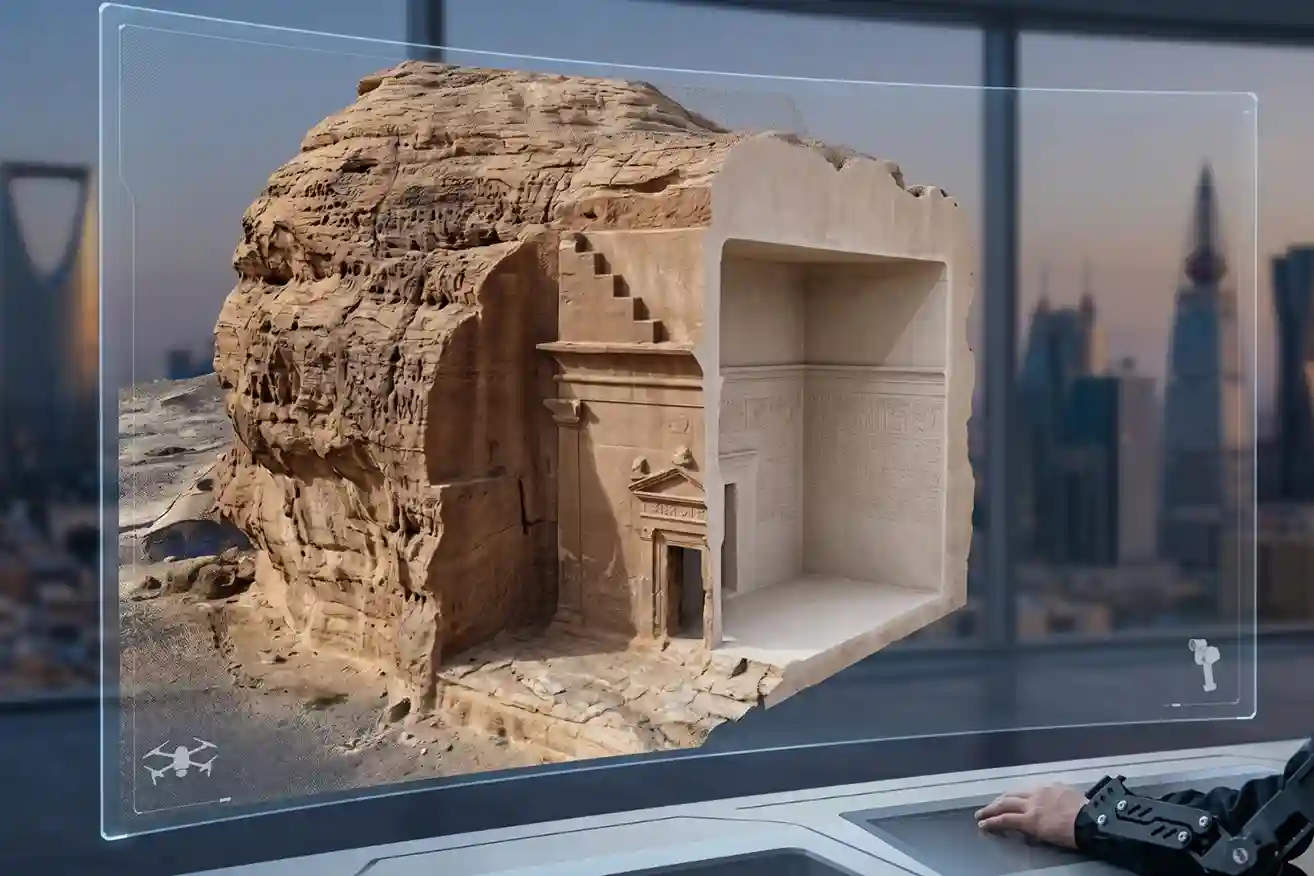
History is not permanent. Even the strongest stones of Al-Ula and the ancient mud-brick walls of Diriyah face a silent, constant threat from time, weather, and the natural process of decay. While we cannot stop the clock, we now have the technology to create a perfect digital backup of these treasures before they change forever. A digital twin is more than just a 3D photo; it is a precise, measurable replica that allows us to study, protect, and even rebuild our heritage if the original is ever lost to the elements.
Why We Must Preserve Our History Today
Preserving historical assets with modern technology is no longer a luxury—it is a necessity for several vital reasons:
- Maintaining Original Form: Using precision tools like LiDAR and SLAM ensures we have a “ground truth” record that is mathematically exact, preserving every stone and inscription in its current state.
- Engineering and Restoration: Digital twins act as a blueprint for conservationists to detect structural health, such as widening cracks or bowing walls, allowing them to rebuild or reinforce heritage sites to their early-day glory.
- Education and Research: Detailed 3D models provide an immortal classroom where students and researchers can study ancient foundations and irrigation patterns that have been invisible for millennia.
- Immersive New Experiences: These navigable digital environments allow people to “walk” through history, offering photorealistic virtual tours of restricted or fragile areas like the inner chambers of Hegra’s tombs.
- Cultural Insurance: At its core, this technology provides the “ultimate insurance policy” for our cultural identity, ensuring that the legacy of our ancestors is never truly lost.
Mapping The Unseen
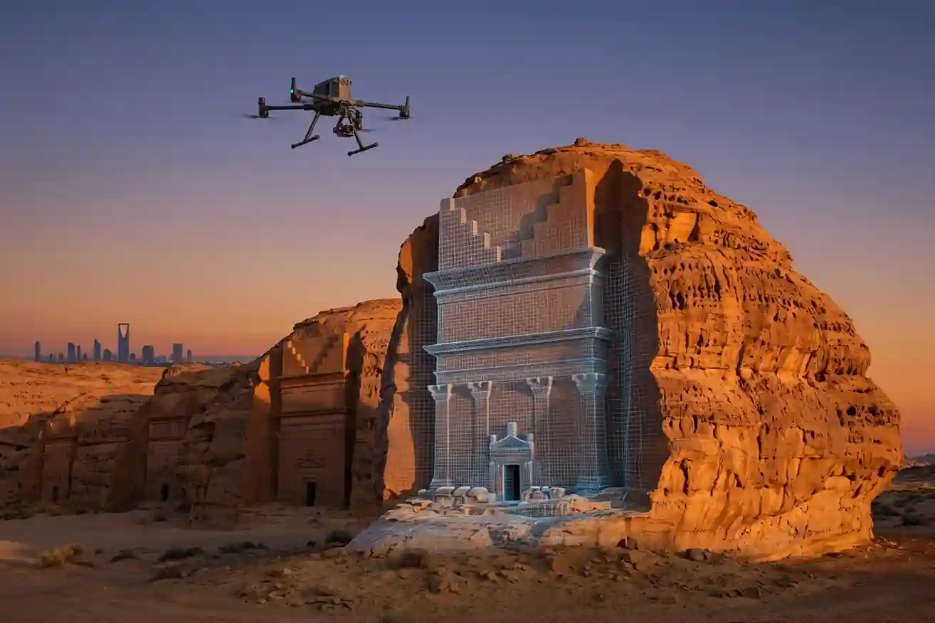
When paired with the Zenmuse L3, the system uses a high-performance laser scanning method to map large landscapes from a safe distance of up to 950 m away.
- 16-Return Laser Technology: One of the most critical features for historical preservation is the L3’s ability to generate up to 16 returns per pulse. This means the laser can bounce off multiple layers, such as desert scrub or palm tree canopies, to eventually hit the true ground. For sites like Khaybar or Al-Ula, this allows archaeologists to digitally strip away vegetation and find ancient foundations hidden beneath the surface.
- Extreme Accuracy: The system achieves a vertical accuracy of 3 cm at a flight altitude of 120 m, ensuring that the digital replica is a perfect mathematical match for the original structure.
Intelligent Navigation
Preserving history often means flying in complex, high-risk environments where one wrong move could damage a fragile monument.
- Omnidirectional Sensing: The M400 is equipped with a penta-vision sensing system. This includes full-color fisheye vision sensors, a horizontal rotating LiDAR, and six-direction millimeter-wave (mmWave) radar. Together, they provide 360-degree obstacle detection, allowing the drone to safely navigate within 200 m of a cliffside tomb or an ancient palace wall, even in low-light conditions.
- Power-Line-Level Detection: The integrated radar is so sensitive it can detect thin objects like high-voltage power lines at night, which is essential for protecting the drone while it maps heritage districts near modern infrastructure.
High-Fidelity Colorization: 100MP Visual Context
A digital twin must look as real as the site it represents. The Zenmuse L3 does not just capture geometric points; it colorizes them in real time.
- Dual 100MP Cameras: The payload includes two high-resolution cameras that capture 100 megapixelRGB imagery simultaneously with the LiDAR scan.
- Photorealistic Models: This visual data is automatically draped over the LiDAR point cloud in software like DJI Terra. The result is a “photorealistic” model where every weathered stone and ancient inscription is visible in its true color and texture.
Scaling the Mission
Documentation projects that used to take months can now be finished in a matter of days.
- Single-Flight Coverage: At an operational altitude of 300 m, the system can cover an area of up to 10 km^2in a single mission.
- Daily Output: When pushed to its limits, the M400 and L3 combination can map up to 100 km^2 per day, providing a complete topographic and structural record of entire archaeological landscapes before they are impacted by development or decay.
LiDAR: Mapping the Unseen
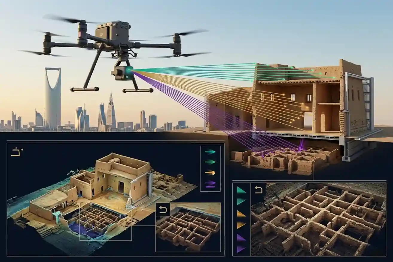
The true breakthrough in preserving the past lies in the physics of the Zenmuse L3’s 16-return laser technology. To understand why this is a “time machine” for archaeology, we must look at how it handles complex environments.
1. Mastering Multi-Layered Penetration
A standard laser pulse might hit the top of a palm tree and stop. However, the L3 emits a high-frequency signal that can record up to 16 distinct echoes (returns) from a single pulse.
- The Sieve Effect: Think of the 16 returns as a sieve. As the laser hits a dense canopy, a portion of the energy continues downward through gaps in the leaves, bouncing off branches, and eventually reaching the true ground surface.
- Layered Discovery: This allows researchers to create “layered” point clouds. By digitally stripping away the first 15 returns (vegetation and debris), we are left with the 16th return—the bare earth. In sites like Khaybar, this reveals ancient foundations and irrigation patterns that have been invisible to the human eye for millennia.
2. Concentrated Energy: The 0.25 mrad Beam
Accuracy in “mapping the unseen” is not just about the number of pulses, but how focused they are. The L3 features a beam divergence of only 0.25 mrad, which is roughly one-fifth the spot size of previous models.
- Precision Targeting: At a flight altitude of 120 meters, this creates a laser spot size of approximately 41 mm.
- Gap Navigation: A smaller, more concentrated laser spot is far more likely to “find” tiny gaps between foliage to reach the ground. This leads to a significantly higher ground point density, ensuring that even subtle structural anomalies like the slight rectangular rise of a buried mud-brick wall are captured in the data.
3. Massive Data Density (2 Million Pts/s)
Speed and density are the final pieces of the puzzle. The L3 operates at an incredible pulse rate of 2 million points per second.
- High-Speed Completeness: This high density means that even when flying at 15–20 m/s, the drone still blankets the ground with enough laser hits to reconstruct a survey-grade model.
- Star-Shaped Scanning: The system supports a unique star-Shaped scanning mode. Unlike standard linear patterns, this mode scans from multiple angles simultaneously, further increasing the probability of a laser “peeking” under an overhang or a slanted wall in a site like At-Turaif.
4. The “Geospatial Anchor”: High-Precision POS
A million points are useless if they aren’t positioned correctly. The L3 integrates a proprietary high-precision POS (Positioning and Orientation System).
- Micro-Level Stability: It uses an upgraded IMU with a yaw accuracy of 0.02° and pitch/roll accuracy of 0.01°.
- Survey-Grade Results: This ensures that every ground hit, even the ones passing through thick trees, is placed in 3D space with a vertical accuracy of 3 cm. This level of precision is what allows archaeologists to detect the “ground truth” of a site without ever picking up a shovel.
While the sky provides the broad context, the true soul of a landmark is often found within its walls. To create a “Total Digital Record,” we must go where drones cannot fly and where GPS signals vanish. This is where the FJD Trion S2 takes over, providing the high-resolution “boots on the ground” perspective.
SLAM Technology: Navigation Without the Sky
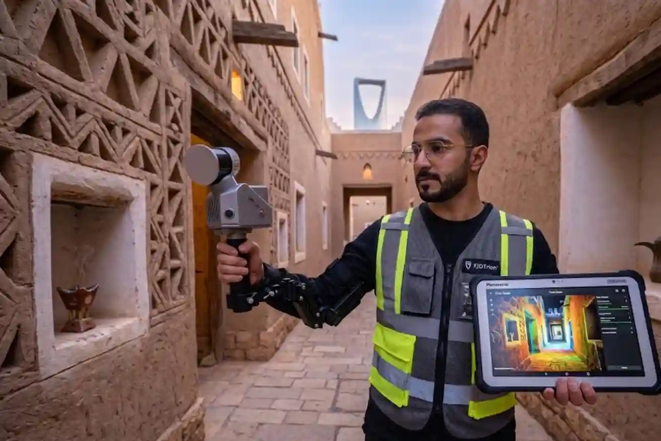
The most critical challenge in preserving sites like the mud-brick palaces of Diriyah or the inner chambers of hegra’s tombs is the absence of GPS signals.
- Multi-SLAM & VIO Algorithms: The Trion S2 does not rely on satellites. Instead, it uses advanced Simultaneous Localization and Mapping (SLAM) combined with Visual-Inertial Odometry (VIO). As you walk through a dark corridor, the device’s dual 12MP cameras and IMU work together to calculate its position by “looking” at the environment and tracking its own movement in 3D space.
- Indoor-Outdoor Continuity: This technology allows for a seamless transition from the bright, open desert into the pitch-black interior of a historical structure. There is no “break” in the data; the scanner maintains its orientation and accuracy even in “GPS-denied” environments, ensuring the interior and exterior models are perfectly aligned.
Real-Time Photorealism
A digital twin of a heritage site is only as useful as its level of detail. The Trion S2 is designed to capture not just geometry, but the very essence of the stone and clay.
- 360° × 270° Field of View: The scanner captures nearly everything in its path in a single pass, minimizing the time spent in sensitive areas.
- Instant Color Overlay: While the LiDAR captures 320,000 points per second, the dual cameras provide a 200° field of view for real-time colorization. This means that as you walk, the point cloud on your tablet screen changes from raw gray dots into a photorealistic 3D model, showing the true colors of ancient pigments or the subtle texture of weathered mud-brick.
Millimeter Precision for Restoration
For conservationists, the S2 acts as a high-precision medical tool for ancient buildings.
- 1.2 cm Relative Accuracy: This level of precision is vital for detecting structural health. It can record the widening of a hairline crack over time or the slight bowing of a 300-year-old wall in Diriyah, providing data that a drone might miss from the air.
- 3 cm Absolute Accuracy: When paired with its integrated RTK module, the S2 can tie its indoor scans to the same global coordinate system used by the Matrice 400, ensuring the “inside” and “outside” data sets merge perfectly.
The Hybrid Technique for A Unified Twin
The final step in our “Total Preservation” workflow is the union of aerial and handheld data.
- Unified Software Ecosystem: Raw data from the S2 is processed through FJD Trion Model software, while the aerial data from the Zenmuse L3 is handled in DJI Terra.
- Cloud-to-Cloud Registration: Using common “tie points” or a shared coordinate system, these two datasets are merged. The result is a single, navigable digital environment where a researcher can start by flying over the Al-Ula desert and then “walk” directly into a tomb to examine the inscriptions on the inner walls—all within the same high-resolution 3D model.
To provide a complete digital record of Saudi Arabia’s heritage, we must move beyond the reach of the sky and into the intricate interiors of the landmarks themselves. The FJD Trion S2 excels in these environments by using a sophisticated navigation method that does not require a single satellite signal.
The Synergy of VIO and SLAM
In the dark, featureless chambers of a tomb or the narrow corridors of a mud-brick palace, standard lidar can sometimes struggle to find enough “landmarks” to maintain its position. The Trion S2 solves this through a dual-layered approach:
- Visual-Inertial Odometry (VIO): The device uses its dual 12MP cameras to visually track its movement while an internal sensor measures every change in speed and direction. This provides a constant “local” position, which is essential when the physical walls are too smooth for the lidar to distinguish one point from another.
- Lidar SLAM: Simultaneously, the lidar scanner creates a 3D map of the environment by firing 320,000 laser points every second. By comparing the VIO data with the lidar’s 3D map, the system achieves a relative accuracy of 1.2 cm, ensuring that even the most complex architecture is recorded with surgical precision.
Eliminating “Drift” with Loop Closure
When walking through a massive site like the palaces of Diriyah, a small error in positioning can grow over time, causing the final digital model to look “bent” or “drifted.”
- Intelligent Path Recognition: The SLAM algorithms in the S2 are designed to recognize a location it has visited before. This is a process called “loop closure”.
- Self-Correcting Accuracy: The moment the operator returns to a previously scanned doorway or corner, the system recognizes the spot and automatically “snaps” the entire 3D model into its correct position, eliminating any accumulated errors.
Real-Time Quality and Global Alignment
Preserving fragile historical sites means every minute spent on-site must be efficient.
- Live Verification: Using the Trion Scan mobile app, operators can see the point cloud grow in real-time on a tablet. This allows them to immediately see if they have missed a dark corner or a high ceiling, preventing the need to return and re-scan a delicate area later.
- 8,000+ Coordinate Systems: To ensure the interior data perfectly matches the aerial maps from the DJI Matrice 400, the S2 supports more than 8,000 global coordinate systems. This means the digital twin is georeferenced from the very first step, allowing the “inside” and “outside” data to merge into one seamless, global record of the landmark.
Building a Legacy That Lasts
Preserving the historical sites of Saudi Arabia is a responsibility we owe to future generations. Digital twins provide the “ultimate insurance policy” for our cultural identity. By using this hybrid workflow, we ensure that every stone, every carving, and every ancient corridor is recorded with mathematical precision.
Let’s talk to find out how our advanced scanning solutions can create a permanent, beautiful, and accurate digital record of your site. Together, we can make sure your history is always alive.

