How Virtual Models Prevent Costly Building Mistakes Before It’s Built
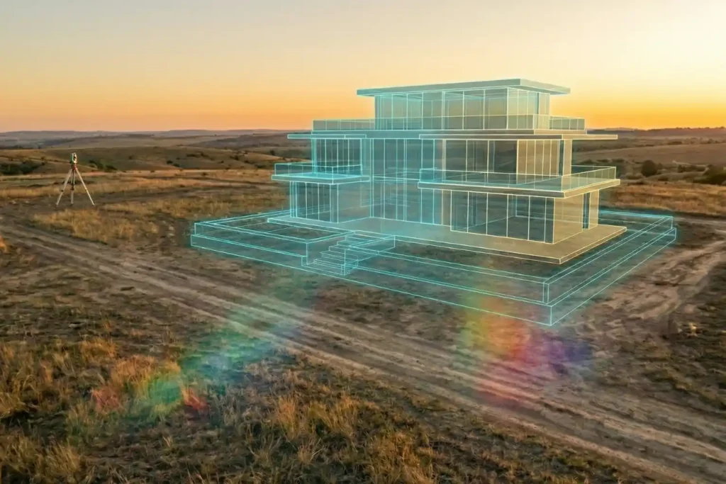
Urban planning is, without a doubt, a beautiful prospect. There is a certain magic in envisioning a skyline defined by luxurious, modern architecture and vibrant communal spaces. But as any developer knows, bringing those sleek glass-and-steel visions to life is where the true challenge begins. Planning a development isn’t as simple as placing pawns on […]
DJI Mavic 3: The Portable Work Drone
For years, professional drone operations were synonymous with large vans, heavy equipment cases, and multi-person crews. However, as we move through 2026, the industry has realized a vital truth: drones alone are no longer enough for operational purposes. While the aircraft gets you into the sky, reliable software is needed to process the large amounts […]
Drone Battery Storage & Safety: The Essential Guide

In recent years, lithium-ion battery incidents have surged globally, with reports showing a 17% increase in related fires due to mishandling during storage and charging. A single lithium battery failure can trigger “thermal runaway,” a catastrophic chain reaction where temperatures spike from 100°C to over 1,000°C in seconds. Alarmingly, over 50% of these fires occur […]
How to Spot Unknown Drones In Your Facilities in Real-Time

For modern oil and gas refineries, the threat from unauthorized drones is no longer theoretical. Whether it is industrial espionage, illegal photography, or potential physical interference, an unknown UAV in your airspace is a major security breach. However, refineries face a delicate challenge: many traditional drone defense systems use high-power radio signals that can interfere […]
How TDOA Technology Secures Airport Airspace Passively

In modern aviation, a single unauthorized drone sighting can paralyze an entire airport in minutes. Unauthorized UAV intrusions lead to grounded flights, diverted passengers, and millions of dollars in operational losses, not to mention the catastrophic safety risks to aircraft during takeoff and landing. However, airports face a unique technical dilemma: many traditional active radar […]
Terra Xross 1: Redefining the Standard for Confined Space Inspection

In the heavy industrial landscape, the most critical assets, such as storage tanks, massive boilers, underground mine shafts, and ship cargo holds are often the most dangerous to inspect. Traditional manual methods require scaffolding, specialized high-risk permits, and placing human lives in dark, dusty, and oxygen-depleted environments. The Terra Xross 1, developed by Terra Drone […]
Airins’ Autonomous Solutions: Transforming Environmental Monitoring

As we move through 2026, the global push toward Net-Zero and environmental accountability has reached a critical inflection point. Traditional monitoring relying on manual sampling or static sensors is no longer sufficient to meet the speed and precision required by modern regulatory frameworks like OGMP 2.0. The “blind spots” in industrial facilities and aquatic ecosystems […]
How Quadruped Robot Inspects Extreme Industrial 24/7

As Saudi Arabia accelerates toward Vision 2030, the Kingdom’s energy sector is undergoing a profound metamorphosis. Leaders like Saudi Aramco and SABIC are moving beyond traditional maintenance toward a future defined by digital twins and unstaffed facilities. However, the bridge between a virtual model and a physical refinery is data—specifically, high-fidelity, real-time data collected from […]
How the FJD Trion V10i Redefines Centimeter Precision

In 2026, the margin for error in industrial surveying has effectively vanished. As we move toward a world of autonomous site governance and high-fidelity digital twins, the 1–2 centimeter accuracy range has transitioned from a specialized requirement to the baseline standard for every project. However, achieving this level of precision is rarely a “plug-and-play” affair. […]
FJD Trion Series: The GNSS Ecosystem for Every Operational Frontier

In 2026, centimeter-level accuracy is no longer a luxury, it is the prerequisite for the modern industrial site. Whether automating a tractor for row-crop optimization, guiding an excavator on a complex construction project, or deploying autonomous robotic mowers, high-precision geospatial data serves as the invisible backbone of efficiency. However, the modern operational environment is multi-faceted. […]
