


Developing primary infrastructure across Oxagon’s 48 km² core industrial zone along the Red Sea coast requires creating accurate, high-density 3D spatial baselines.
Designed as an automated port, clean energy, and industrial hub within NEOM, Oxagon features a complex shape of infrastructure networks.
These include multi-utility rights-of-way, heavy haul transport roads, freight rail lines, high-voltage distribution lines, and green hydrogen supply pipelines connecting the Port of NEOM to the NEOM Green Hydrogen Company (NGHC) production plant and surrounding industrial sectors.
Establishing spatial baselines across extended linear utility corridors presents operational challenges for civil engineering teams.
Traditional ground survey methods using total stations and optical GNSS rovers require survey crews to traverse vast desert terrains, navigate active heavy construction zones, and coordinate access across active earthwork sites.
These manual field methods are slow, expose survey personnel to site traffic hazards, and struggle to deliver continuous elevation profiles across extended multi-kilometer rights-of-way.
As giga-projects expand nationwide, market reporting from Fortune Business Insights showing the global drone inspection and maintenance market reached SAR 37.91 billion in 2026 and is projected to expand to SAR 132.56 billion by 2034, driven by mega-infrastructure developments adopting automated aerial topographic and corridor mapping baselines, underlines the industrial pivot toward automated spatial data collection.
Deploying heavy-lift airborne LiDAR systems establishes unified spatial coordinates, allowing master planners, utility owners, and EPC contractors to coordinate design workflows without schedule delays.
Drone LiDAR and Point Cloud Generation
Conducting high-density airborne laser scanning across extended rights-of-way requires robust flight platforms and specialized remote sensing payloads.
Deploying heavy-lift aircraft, such as the دي جي آي ماتريس 400 (إم 400) equipped with the DJI Zenmuse L3 LiDAR and photogrammetry payload, provides the extended flight range, positioning accuracy, and sensor resolution necessary for large-scale linear corridor mapping across NEOM Oxagon.
Heavy-Lift Enterprise Platforms and Multi-Return Sensor Architecture

The heavy-lift DJI Matrice 400 platform delivers the operational range, flight stability, and system redundancy required to map multi-kilometer utility corridors in single operational sorties.
Built with an IP55 ingress protection rating, the aircraft operates reliably in harsh coastal environments, enduring ambient desert temperatures exceeding 45°C, high humidity, and sustained sea winds up to 12 m/s along the Red Sea coastline.
Dual-battery hot-swapping and redundant flight control systems ensure continuous field operations with minimal ground downtime between missions.
Mounting the DJI Zenmuse L3 payload on the Matrice 400 creates an integrated airborne laser scanning and photogrammetric acquisition system:
- High-Frequency Multi-Return LiDAR Sensor: The sensor emits laser pulse frequencies up to 2,000 kHz, acquiring up to 2,000,000 points per second. Supporting up to 16 returns per pulse allows emitted laser beams to pass through sparse desert scrub vegetation, dust layers, security mesh fencing, and overhead utility lines to strike the true ground surface underneath.
- High-Precision Positioning and Inertial Navigation: An integrated high-accuracy Inertial Measurement Unit (IMU) works in tandem with real-time kinematic (RTK) GNSS positioning (delivering 1 cm + 1 ppm horizontal accuracy) to log exact sensor orientation (pitch, roll, and yaw) and 3D spatial coordinates (X,Y,Z) for every reflected laser pulse.
- Dual 100 MP RGB Mapping Cameras: Dual 4/3 CMOS sensors with mechanical shutters eliminate rolling shutter distortion during high-speed flight passes. The cameras capture ultra-high-resolution photogrammetric imagery simultaneously with the laser scan, colorizing the 3D point cloud in real time and generating true-color orthomosaic basemaps.
Operational Execution and Flight Planning Along Multi-Utility Corridors
Flight operations along NEOM Oxagon’s utility rights-of-way are managed through automated mission planning software.
Survey teams map linear flight corridors along planned heavy haul roads, pipe easements, and power distribution paths.
Using real-time terrain-following flight modes driven by existing elevation baselines, the Matrice 400 maintains a constant height Above Ground Level (AGL) across undulating terrain.
Maintaining a uniform flight altitude ensures consistent ground laser swath width, constant point density (exceeding 100 to 200 points per square meter), and uniform image ground sampling distance (GSD).
Corridor flights execute with a 60% to 70% lateral strip overlap to eliminate spatial coverage gaps along outer corridor boundaries.
Flight routines incorporate dynamic figure-8 calibration maneuvers before and after data collection passes to calibrate the IMU, ensuring high orientation precision across long linear flights.
Ground survey teams place pre-marked Ground Control Points (GCPs) and independent check points at key corridor intersections to validate absolute horizontal and vertical coordinate accuracy during post-processing.
Quantifying Field Lead-Time Reductions and Operational Survey Cost Savings
Transitioning from manual ground survey walks to airborne laser scanning significantly accelerates data acquisition timelines while removing workers from hazardous environments.
Mapping linear infrastructure from safe flight altitudes eliminates the need to deploy ground survey crews onto active logistics roads, deep trenching excavations, or unexploded ordnance clearance zones.
Operational research published by the Washington State Department of Transportation demonstrating that replacing traditional manual ground survey teams with airborne LiDAR mapping across linear transportation and utility rights-of-way reduces field survey lead times by 60% to 80% while eliminating worker exposure to heavy site traffic and environmental hazards highlights the field safety and speed achieved through aerial flight passes.
In addition to safety improvements, airborne LiDAR workflows deliver substantial cost and schedule savings for mega-project developers.
Capturing high-density 3D spatial data in days rather than months reduces field staffing requirements, equipment rental costs, and site access coordination delays.
Furthermore, comparative field evaluations published on ResearchGate proving that deploying UAV-based topographic corridor mapping over traditional terrestrial survey methods achieves a 52% direct cost reduction in surveying operations and shortens overall project completion duration by 45.45% due to reduced personnel deployment, transportation overhead, and field equipment requirements confirm the economic advantage of airborne laser scanning.
Bare-Earth Digital Terrain Model (DTM) Extraction and Clash Detection
Raw 3D point clouds captured over active industrial development zones contain complex spatial noise and surface obstructions.
Unprocessed point cloud datasets captured across NEOM Oxagon contain millions of ground elevation points mixed with non-ground surface features, including earthmoving machinery, parked transport trailers, temporary site offices, aggregate stockpiles, high-voltage power lines, and desert scrub vegetation.
To construct an accurate engineering design baseline, geospatial analysts must process raw point cloud files through specialized filtering routines to isolate the true bare-earth surface underneath.
Point Cloud Filtering and Automated Bare-Earth Classification
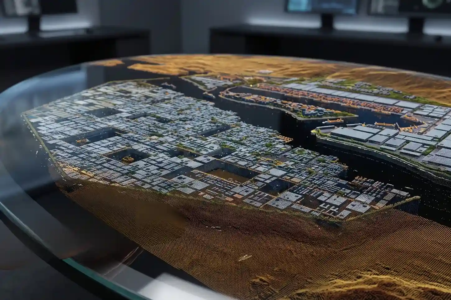
Post-processing raw LiDAR data files captured by the DJI Zenmuse L3 begins inside processing software platforms like DJI Terra and specialized point-cloud processing suites.
Raw LAS/LAZ files containing XYZ spatial coordinates, laser return intensity, and pulse return numbers undergo automated point-cloud classification algorithms.
Advanced spatial filtering routines, including Progressive Morphological Filtering (PMF) and Cloth Simulation Filtering (CSF), analyze local geometric relationships between neighboring laser points to separate ground returns from above-ground objects.
Multi-return laser pulse architecture plays a critical role during terrain classification.
When a laser pulse encounters overhead transmission cables, construction rigging, or scrub vegetation, initial pulse returns (returns 1 through 3) reflect off upper structures, while final pulse returns (up to return 16) penetrate spatial gaps to strike the solid ground surface.
Automated algorithms classify first returns as non-ground objects and isolate final returns as true ground hits.
Geospatial technicians perform manual quality control passes across complex terrain features, such as steep trench walls, roadway shoulders, and drainage culverts to verify point classification accuracy before generating continuous surface meshes.
Hydrodynamic Surface Modeling and Sub-Decimeter Vertical Precision
Once point cloud classification isolates bare-earth ground points, geospatial software generates high-resolution Digital Terrain Models (DTMs) and Digital Elevation Models (DEMs) using Triangulated Irregular Network (TIN) interpolation.
Generating sub-decimeter vertical elevation accuracy is essential across NEOM Oxagon’s coastal terrain, where natural ground slopes are exceptionally flat, often exhibiting elevation changes under 0.5% toward the Red Sea shoreline.
Imprecise surface elevation data introduces severe errors into hydraulic runoff modeling and road grade design.
Geospatial studies published on ResearchGate establishing that utilizing high-resolution airborne LiDAR Digital Elevation Models (DEMs) for terrain analysis eliminates severe elevation errors found in conventional 1:5000 topographic maps which exhibit a Mean Absolute Error of 56.9 cm and a Root Mean Square Error (RMSE) of 76.4 cm, delivering sub-decimeter surface precision required for narrow rights-of-way and utility alignments demonstrate why airborne LiDAR is essential for engineering design.
High-precision DTMs allow municipal and civil engineers to accurately model surface water drainage, determine exact pipe invert elevations (INV), and prevent localized water pooling along multi-utility rights-of-way during heavy storm events.
3D Underground Utility Clash Detection and Earthwork Optimization
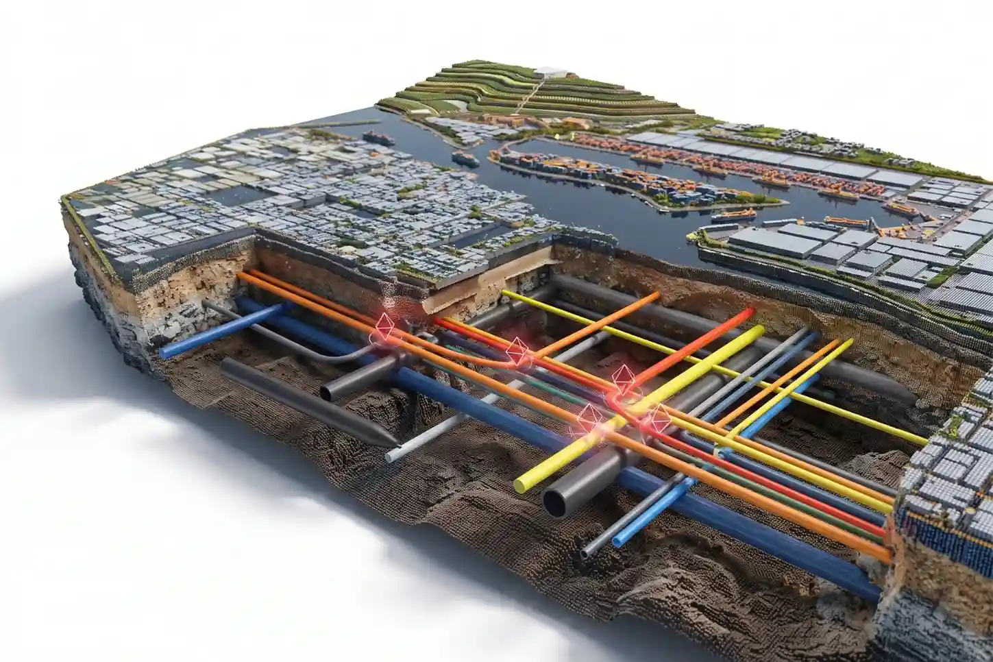
Establishing a verified bare-earth surface baseline enables multi-disciplinary 3D clash detection across complex utility corridors.
Utility rights-of-way in NEOM Oxagon host multiple parallel infrastructure networks, including potable water mains, recycled irrigation lines, district cooling pipes, high-voltage power cables, telecommunication conduits, and fuel pipelines.
Overlaying proposed 3D Building Information Modeling (BIM) utility models directly onto the high-density LiDAR bare-earth surface reveals spatial intersections and elevation conflicts between proposed pipes, road sub-bases, and existing ground obstacles prior to trenching.
Identifying geometric clashes in the digital planning phase prevents utility strikes, eliminates emergency design modifications, and avoids costly field rework during construction execution.
Engineering cost models published on ResearchGate showing that integrating high-precision spatial modeling into early linear utility and master infrastructure plans reduces capital construction earthwork costs by an average of 19% compared to conventional ground survey planning methods validating the immediate financial return of accurate pre-construction mapping.
Furthermore, precise airborne DTMs optimize large-scale earthmoving operations along heavy transport corridors and freight rail beds.
Comparing high-resolution pre-construction LiDAR baselines with proposed finished grade designs allows project control teams to calculate exact cut-and-fill material volumes.
Balancing earthwork distribution along linear corridors minimizes material haul distances, reduces imported fill costs, and optimizes heavy machinery fuel consumption across NEOM Oxagon development sectors.
Enterprise GIS Integration and Digital Twin Asset
The primary value of airborne LiDAR mapping lies in transforming raw physical point cloud data into actionable spatial intelligence across enterprise platforms.
Capturing high-density 3D terrain models along NEOM Oxagon’s multi-utility corridors provides immediate engineering value only when integrated into centralized digital governance systems accessible to master planners, utility operators, EPC contractors, and municipal authorities.
Seamless Multi-System Interoperability and Spatial Data Pipelines
Exporting raw geospatial deliverables into enterprise environments requires structured data pipelines that maintain absolute coordinate precision across software ecosystems.
Raw 3D point cloud files captured by the DJI Zenmuse L3 are exported in industry-standard LAS/LAZ formats, colorized using true-color RGB imagery, and georeferenced to the local WGS84 / UTM zone spatial reference system.
These point clouds process into high-resolution GeoTIFF orthomosaics, 3D textured scene layer packages (.SLPK), and bare-earth Digital Terrain Models (DTMs).
To support multi-disciplinary engineering workflows, these spatial datasets export directly into enterprise platforms, including Esri ArcGIS Enterprise, Autodesk Civil 3D, and Bentley OpenRail:
- Enterprise GIS Integration: Georeferenced DTMs and orthomosaics convert into hosted map layers and 3D web scenes inside ArcGIS Enterprise dashboards. This provides real-time spatial visibility to project managers, municipal permit reviewers, and utility owners without requiring desktop GIS software.
- BIM and CAD Coordination: High-density ground point clouds import directly into Autodesk Revit and Civil 3D environments. Civil engineers utilize true surface point clouds as the direct geometric baseline for road corridor grading, pipe trench alignment, and structural foundation design.
- Common Data Environment (CDE) Sync: Spatial layers link directly to Common Data Environments used across NEOM Oxagon, establishing a single spatial source of truth that connects 2D design drawings directly to 3D field reality.
Regulatory Compliance, Airspace Approvals, and Data Governance
Executing drone LiDAR surveys across giga-project developments requires strict adherence to national aviation, geospatial, and cybersecurity regulations across the Kingdom of Saudi Arabia.
Operating enterprise drone fleets near critical port facilities, industrial plants, and utility corridors involves multi-agency regulatory coordination:
- GACA Flight Approvals: Flight operations comply with General Authority of Civil Aviation (GACA) Part 107 regulations. Remote pilots hold valid GACA Remote Pilot Certificates, and all aircraft maintain active GACA commercial registrations.
- Airspace and NOTAM Coordination: Flight paths along coastal and industrial corridors receive formal clearance through Saudi Air Navigation Services (SANS), with Notice to Airmen (NOTAM) filings issued via the Ajwaa digital portal prior to flight execution.
- GEOSA Spatial Data Authorization: Survey and mapping activities adhere to General Authority for Survey and Geospatial Information (GEOSA) permit requirements for aerial photography and topographic survey data collection.
- SDAIA Data Privacy and NCA Security Controls: In accordance with Saudi Data and Artificial Intelligence Authority (SDAIA) guidelines and National Cybersecurity Authority (NCA) Essential Cybersecurity Controls (ECC), all captured imagery, point clouds, and asset locations undergo strict data classification. Geospatial data is encrypted during transmission and stored on secure local server architectures or compliant sovereign cloud instances.
Long-Term Lifecycle Cost Reduction and Digital Twin Asset Registry
Establishing a verified 3D spatial baseline transforms static post-construction handover drawings into a dynamic operational digital twin.
As utility corridors across NEOM Oxagon transition from active civil construction into long-term operations, recurring aerial drone surveys provide continuous asset management capabilities.
Repeat drone LiDAR flights enable automated change detection across linear rights-of-way.
Comparing time-stamped point clouds against historical baselines allows facility management teams to detect unauthorized ground excavations, identify right-of-way encroachments, monitor slope erosion along drainage channels, and audit contractor reinstatement work.
Infrastructure research published on ResearchGate proving that implementing digital twin frameworks and automated spatial sensor integration across linear utility corridor networks reduces long-term infrastructure lifecycle costs by up to 25% and lowers operational risk exposure by 30% demonstrates the financial return of maintaining an integrated digital twin asset registry.
Centralizing high-density airborne LiDAR baselines ensures that NEOM Oxagon’s critical utility networks are designed, constructed, and managed on a precise, verifiable spatial foundation throughout their operational lifespan.
Consult with Our Experts
Streamline your utility corridor mapping, high-density airborne LiDAR surveys, and 3D infrastructure digital twin workflows.
Contact our specialist to deploy advanced drone solutions for your project developments.

 العربية