

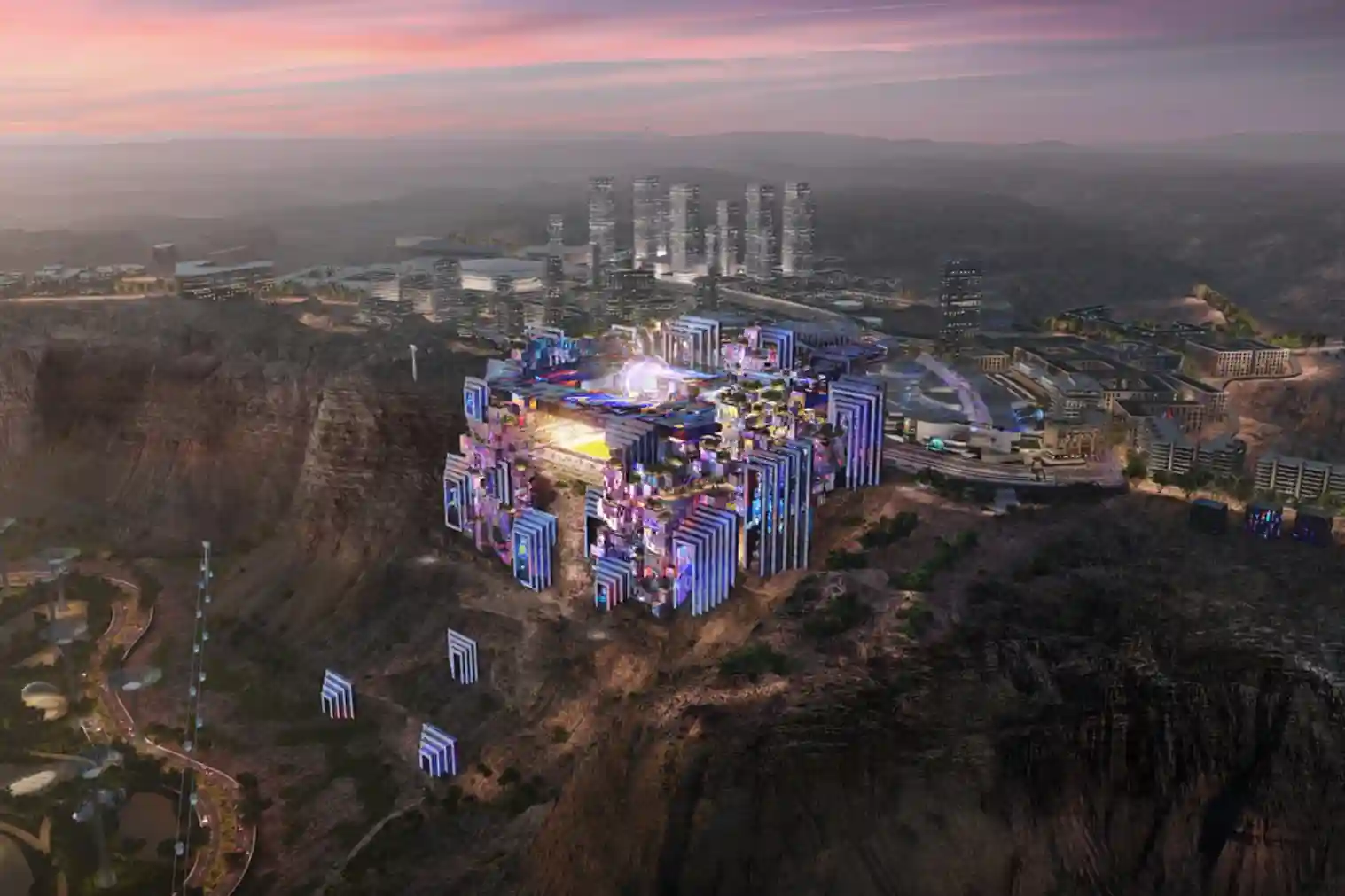
The construction of the Prince Mohammed bin Salman Stadium represents a significant architectural shift in global sports infrastructure.
It stands as a crown jewel of the Qiddiya gigaproject, built directly atop a breathtaking, vertical 200-meter-high Tuwaiq cliff edge that overlooks the Qiddiya entertainment district.
Designed to serve as a premier venue for the 2027 AFC Asian Cup, this multi-purpose arena has also been officially designated as a high-profile quarter-final and third-place playoff host venue for the upcoming 2034 FIFA World Cup.
The facility features an official tournament design footprint engineered to hold 46,979 seats, fully compliant with strict FIFA stadium guidelines.
To provide an adaptable tournament experience, the architectural envelope incorporates three highly complex moving structures: a fully retractable roof framework, a rolling retractable pitch system, and a massive 1.5-kilometer visual LED wall panel array integrated directly into the surrounding mountain rock.
Building a mega-project on a sheer cliff face while maintaining millimeter-level movement spaces for these retractable components introduces severe geotechnical and geomatics risks.
Managing sudden mountain wind shear, monitoring cliff slope movements, and ensuring multi-level structural alignment require an absolute, real-time spatial data tracking framework.
The Challenge: Rugged Terrain
Steep Topography and the Megaproject Delay Trap
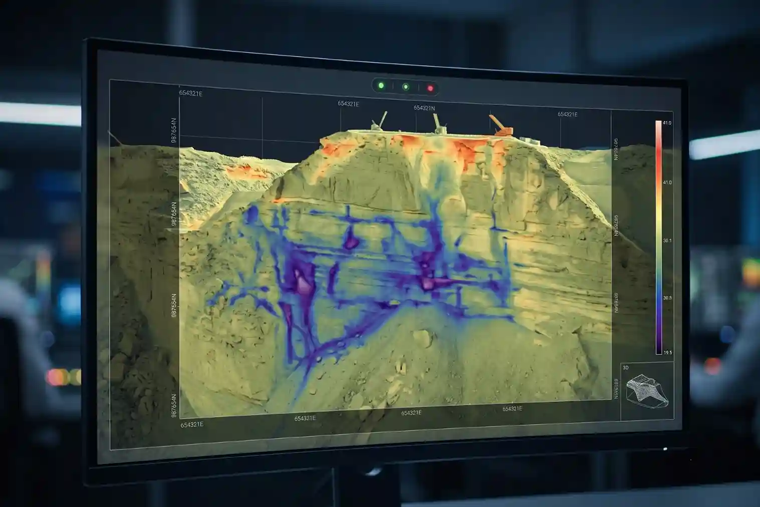
Building a massive modular stadium on an extreme, uneven cliff edge introduces heavy technical complexities.
Traditional ground-based surveying techniques face severe operational limits when deployed across volatile mountain terrain.
When project management teams rely on manual visual checks, line-of-sight tripods, and disconnected spreadsheets, structural tracking errors go entirely unnoticed.
This spatial data fragmentation between separate subcontractors often leads directly into the global project trap where 77% of all megaprojects experience severe execution delays, pushing final delivery timelines at least 40% late.
On a cliffside construction site, structural alignment risks compound exponentially because subcontractors work simultaneously across multiple distinct vertical layers.
While specialized crews install deep rock anchors to reinforce high-risk slope sections, separate structural groups build multi-tier concrete foundations, and mechanical technicians prepare the tracks for the retractable pitch.
If the primary reference coordinates contain even a minor baseline error, the entire physical site alignment fails.
Traditional ground teams cannot safely access vertical rock faces daily to cross-check positions. Consequently, minor shifts in the mountain retaining structures can go completely undetected for weeks, causing crews to continuously build on top of inaccurate layout coordinates.
When engineering groups make critical design decisions using outdated or incorrect spatial data, the financial consequences compound immediately.
Global infrastructure metrics confirm that this systematic reliance on “bad data” is directly responsible for 14% of all construction rework executed across major development projects. When scaled up to a national mega-project level, the financial losses are massive:
- Avoidable field reworks caused entirely by poor spatial data quality cost the global construction sector an estimated SAR 333 billion in a single calendar year.
- For a tier-1 infrastructure contractor generating SAR 3.7 billion in annual revenue, data tracking inefficiencies cause a hidden financial drain of up to SAR 619 million per year.
- Out of that total loss, poor site data quality causes an immediate, unrecoverable cash loss of SAR 26 million spent physically tearing down freshly poured, misaligned structural elements.
Discovering a major design clash late forces an immediate stop to all related installation tasks, causing a crushing 300% drop in localized worker productivity.
Heavy crane operators, structural steelworkers, and mechanical technicians are forced to sit completely idle while engineering offices redraw layout plans and order expensive replacement parts.
Minor Structural Shift ➔ Compounds Vertically ➔ Pre-Fab Component Mismatch ➔ 300% Field Productivity Drop
This sudden operational freeze quickly delays subsequent trades, stalling the installation of the 1.5-kilometer LED wall array, delaying electrical utility routing, and compromising sub-surface safety barriers.
Utilizing Drone & Geospatial Solutions
Terra Drone Arabia optimizes the entire construction lifecycle by deploying specialized, end-to-end aerial services and multi-sensor configurations:
1. The Solution: DJI Matrice 400
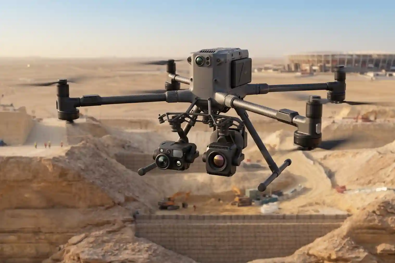
To eliminate construction visibility gaps across this difficult mountain terrain, advanced aerial intelligence is required to bridge the gap between ambitious architectural designs and harsh physical realities.
This high-frequency scanning operation utilizes the flagship DJI Matrice 400 commercial drone platform.
The aircraft frame is built specifically to operate reliably within high-risk industrial environments, supporting an expanded payload lift capacity of 6 kg.
The platform features a maximum flight endurance of 59 minutes and operates at a maximum horizontal cruise velocity of 25 m/s.
This high-speed capability allows the automated flight software to complete dense mapping grids quickly without requiring ground safety clear-outs or putting personnel in high-risk vertical climbing zones.
2. Land Surveying & LiDAR via Terra LiDAR One
To generate high-density 3D point clouds and millimeter-accurate digital twins for initial design and automated Cut & Fill Analysis, the team deploys the survey-grade Terra LiDAR One workflow.
This operation utilizes the DJI Zenmuse P1 payload on the drone’s dual-gimbal configuration.
The Zenmuse P1 is engineered with a high-fidelity 45MP full-frame CMOS sensor to record fine physical details across complex glass facades, concrete tiers, and mechanical support tracks.
The payload operates with tight survey-grade precision, securing an absolute mapping accuracy of 3 cm horizontally and 5 cm vertically without requiring teams to manually place ground control points (GCPs) across dangerous, inaccessible rock faces.
Operating at an optimized flight grid, the sensor maps up to 3 square kilometers in a single flight run , delivering the foundational topography data required to verify physical boundaries.
3. Geohazard Prevention via Automated Slope Monitoring
Continuous, automated aerial Slope Monitoring of the 200-meter cliff face is vital to mitigate landslide, rockfall, and ground-shifting risks, ensuring long-term structural integrity.
For this role, the second gimbal position carries the DJI Zenmuse H30T multi-sensor payload to monitor geotechnical risks and verify moving mechanical borders.
Zenmuse H30T Payload Integrated Capabilities:
- Radiometric Thermal (1280×1024) ➔ Maps Subsurface Seepage & Heat Fatigue.
- Advanced Target Zoom (34x Optical) ➔ Inspects High-Risk Cliff Fractures Safely.
- Laser Rangefinder (3–3,000m Scope) ➔ Verifies Retractable Pitch & Roof Clearances.
The sensor utilizes an uncooled radiometric infrared thermal camera featuring an advanced 1280×1024 pixel thermal resolution.
This high-resolution thermal tracking maps small temperature changes across the rock face, allowing geotechnical engineers to locate hidden subsurface water leaks, internal concrete voids, or structural heat fatigue before physical cracks appear on the surface.
To examine distant structural joints safely, the sensor uses a high-magnification lens system capable of 34x optical zoom and up to 400x digital zoom.
Additionally, the integrated laser rangefinder module is accurate from a distance of 3 to 3,000 meters away.
The geomatics team uses this module to measure the precise clearance boundaries for the moving retractable roof and the rolling retractable pitch.
Measuring these mechanical borders continuously ensures that the physical clearances match original design tolerances exactly, preventing expensive friction damage or mechanical binding when the stadium structures move during tournament operations.
4. BIM Integration & Project Management via Terra 3D Inspect
Aerial data is converted into accurate CAD & BIM Modeling via our Terra 3D Inspect cloud platform.
Once the weekly flight grids are completed, the clean, distortion-free 3D reality mesh is directly overlaid onto the central Building Information Modeling (BIM) files.
Engineers use this integrated platform to check structural columns, verify floor elevations, and ensure that the multi-level building framework matches the design requirements exactly.
By identifying these structural clashes early through drone-based tracking, the construction consortium completely bypasses the 14% bad-data rework trap.
This digital twin workflow provides project owners with a highly reliable visual and technical ledger of real-world progress, allowing stakeholders to track construction progress seamlessly.
5. Site Safety Compliance via Terra Patro
To protect thousands of on-site workers across this high-density development, the Terra Patro drone surveillance workflow monitors high-risk zones and multi-level vertical construction layers.
Because a cliffside project introduces a hazardous environment surrounded by active heavy machinery and vertical drops, manual safety audits are slow and dangerous.
Because the drone can map the entire cliff face safely from an elevated vantage point, the team completes routine site safety compliance tracking without requiring ground safety clear-outs or putting personnel in high-risk vertical climbing zones.
The automated aerial data captures safety violations, unsecured scaffolding, or unstable ground terrain in real-time, proactively identifying hazards to prevent site accidents and secure tight project schedules.
خاتمة
Tomorrow’s mega-structures are being safely and efficiently built today using Terra Drone Arabia’s cutting-edge aerial innovations.
Switching from manual ground surveying to automated drone-based multi-sensor tracking provides the spatial precision required for modern, complex sports venues.
Drone tracking protects infrastructure budgets, tracks cliffside geological safety, and ensures that complex moving components remain perfectly aligned.
Are you building a flagship venue? Consult with our expert.

 العربية