

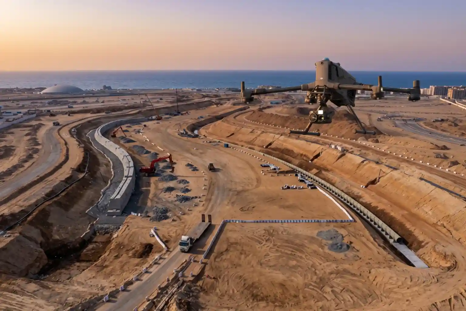
ROSHN Group’s landmark MARAFY development encompasses over 9.4 million square meters of connected waterside districts in northern Jeddah.
The central feature of this master plan is Saudi Arabia’s first navigable urban water channel, extending 11 kilometers in length and over 100 meters in width to connect Obhur Creek inland.
Civil engineering teams have made rapid progress along the initial 2.5-kilometer corridor, completing 80% of Phase 1 excavation.
Earthmoving operations have displaced approximately 2.45 million cubic meters of soil and rock to carve out the coastal channel.
Subsurface Dewatering and Retaining Wall Challenges
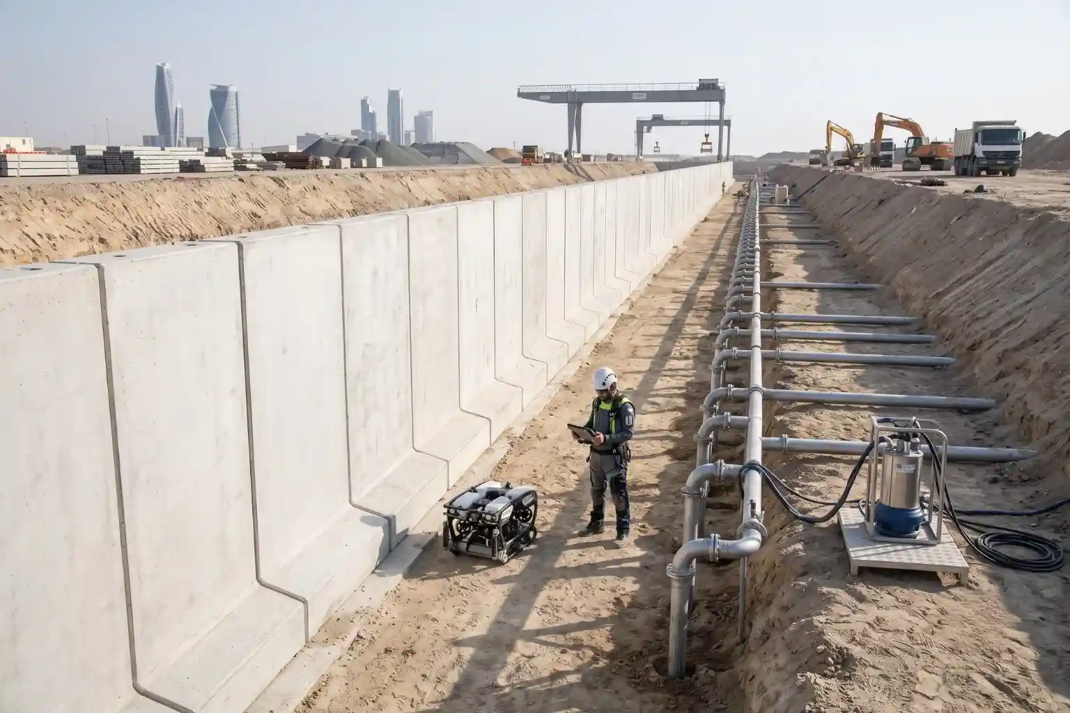
Constructing a navigable marine canal connected directly to the Red Sea introduces complex ground engineering and hydrogeological demands.
As earthmoving operations advance across coastal soils, managing subsurface water movement and structural wall stability becomes critical to civil safety and project timelines.
Coastal Hydrogeology and Hydrostatic Pressure Dynamics
The geological conditions along northern Jeddah consist of permeable coastal marine sediments, coralline limestone strata, and shallow groundwater tables fed by proximity to Obhur Creek.
As excavation crews dig down to form the 100-meter-wide channel footprint, surrounding groundwater naturally migrates toward the open trench.
This hydrogeological dynamic generates significant hydrostatic head pressure against freshly exposed trench slopes.
To maintain a dry and stable working environment during excavation, engineering teams deploy deep dewatering systems consisting of perimeter wellpoint arrays and high-capacity submersible pumps.
If hydrostatic pressure is left unmanaged, rising groundwater can cause slope instability, trench wall collapse, or soil liquefaction during foundation works.
Structural Mechanics of Precast Quay Wall Installation
To stabilize the canal banks against coastal erosion and soil movement, civil contractors have installed more than 1,250 linear meters of precast concrete quay and retaining wall structures along early modules.
These heavy precast panels resist both lateral earth pressures from the soil behind them and dynamic wave forces from the canal water in front.
However, the interface between the backfill soil, deep dewatering wells, and concrete quay panels remains vulnerable to subterranean water movement.
High groundwater head pressure can drive water through micro-fissures in panel joints or underlying foundation beds.
Over time, continuous water seepage carries fine soil particles away, a phenomenon known as soil piping.
This internal erosion creates unseen voids behind the quay wall, which can lead to panel displacement, joint separation, or localized structural subsidence without warning at the surface.
Operational Limitations of Traditional Ground Inspection Methods
Monitoring structural health and dewatering performance across multi-kilometer active construction zones poses severe operational challenges.
Traditional inspection methods rely on ground crews performing manual site walks, visual checks, and localized mechanical monitoring points.
These conventional approaches have major limitations along wide linear corridors:
- Surface Visibility Constraints: Visual checks can only identify water leaks after moisture has penetrated completely through concrete panels or caused visible surface erosion.
- Spatial Coverage Bottlenecks: Manual ground surveys along active excavation trenches are slow, labor-intensive, and difficult to execute daily across extended corridors.
- Environmental Evaporation Interference: High ambient desert temperatures rapidly evaporate surface moisture, obscuring visual signs of minor seepage during daylight hours.
Because subsurface water migration cannot be seen with the naked eye until structural displacement occurs, site managers require wide-area, non-destructive remote sensing methods capable of detecting subterranean thermal and moisture anomalies before concrete retaining walls experience structural failure.
Radiometric Thermal Auditing for Seepage Detection
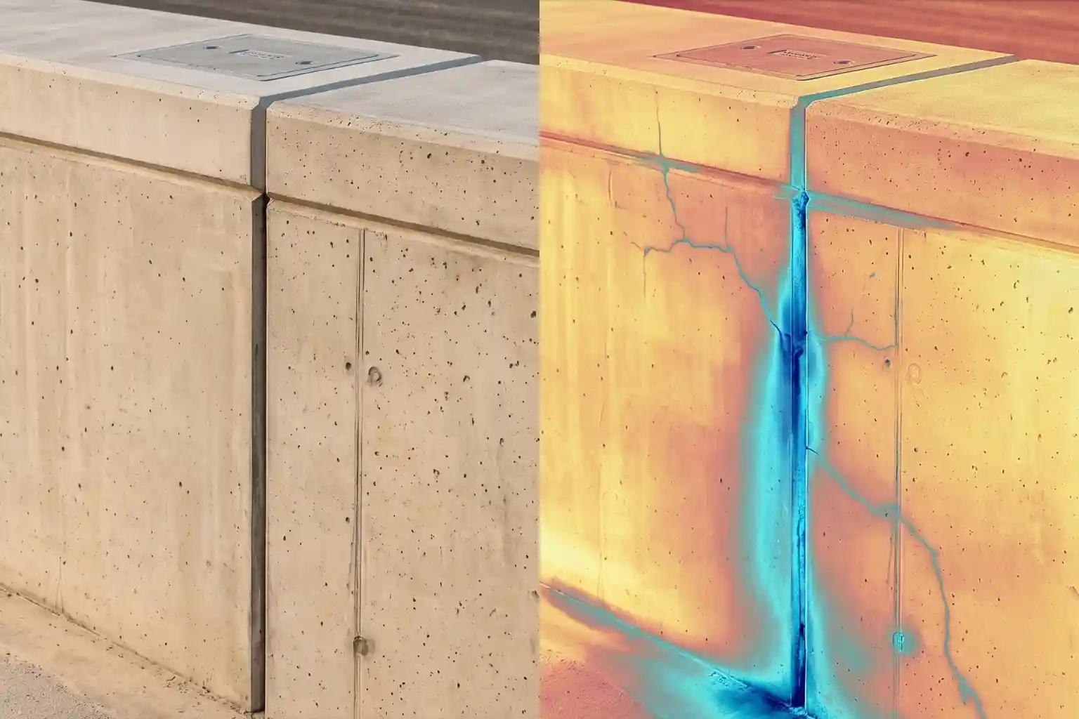
Adopting aerial radiometric thermal inspection provides a non-destructive, wide-area method for auditing civil infrastructure across extended linear corridors.
By capturing infrared radiation naturally emitted from ground surfaces and concrete structures, aerial thermography enables civil engineers to evaluate subterranean hydrogeological behavior without interrupting ongoing site operations.
Principles of Infrared Thermography in Hydrogeological Auditing
Thermal imaging operates on the physical principles of thermal capacity and thermal inertia. Water possesses a significantly higher specific heat capacity than dry sand, coastal soil, and cured concrete.
During daytime solar heating, dry concrete quay panels and unexcavated soil backfill absorb and radiate thermal energy rapidly, resulting in higher surface temperatures.
In contrast, zones containing subsurface moisture accumulation, water pooling, or active seepage exhibit lower surface temperatures during peak daylight hours.
This cooling effect occurs due to the high thermal inertia of water and the latent heat of vaporization as moisture evaporates from exposed surfaces.
During nighttime cooling cycles, the thermal relationship reverses; water-saturated soil retains heat longer than dry surrounding materials.
Radiometric thermal cameras capture these surface temperature differentials. By mapping spatial temperature gradients across precast concrete quay walls and backfill earth, thermal sensors reveal hidden subterranean moisture plumes, void formations, and fluid migration pathways that remain completely invisible to standard visual inspection.
Market Growth and Transition to Automated Leak Detection
Integrating aerial thermal technology into large-scale construction workflows reflects a global industrial transition toward automated civil asset monitoring.
Market data shows that the global leak detection solutions sector is projected to expand at a compound annual growth rate (CAGR) of 11.65%, growing from SAR 18.1 billion in 2026 to reach SAR 23.74 billion by 2031 Mordor Intelligence.
Similarly, the broader global market for leak detection and repair (LDAR) services reached SAR 79.69 billion in 2025 and is forecast to reach SAR 100.8 billion by 2030 Mordor Intelligence.
This sustained financial investment highlights the increasing demand for high-frequency inspection platforms across heavy civil engineering, maritime infrastructure, and utility corridor management.
Mega-projects with extensive linear footprints require automated aerial systems to maintain continuous structural oversight while controlling manual labor outlays.
Early Detection Workflows and Non-Destructive Structural Auditing
Radiometric thermal auditing functions as a non-destructive testing (NDT) solution, eliminating the need for invasive exploratory drilling, soil sampling, or structural excavation along canal banks.
Unlike standard thermal images that only display relative color contrast, radiometric sensors record absolute temperature values for every individual pixel in a thermal dataset.
This pixel-level temperature measurement allows geotechnical engineers to perform precise quantitative analysis across multi-kilometer retaining wall installations.
By converting thermal raw data into georeferenced orthomosaics, site managers can cross-reference thermal anomalies directly against CAD engineering drawings and GIS base maps.
Identifying localized moisture accumulation behind quay walls allows engineering teams to execute targeted preventative maintenance, such as high-pressure polyurethane grouting, joint sealant replacement, or dewatering pump realignment long before subsurface soil piping leads to concrete wall displacement or embankment failure.
Technical Platform Execution with the DJI Matrice 400 and Zenmuse H30T
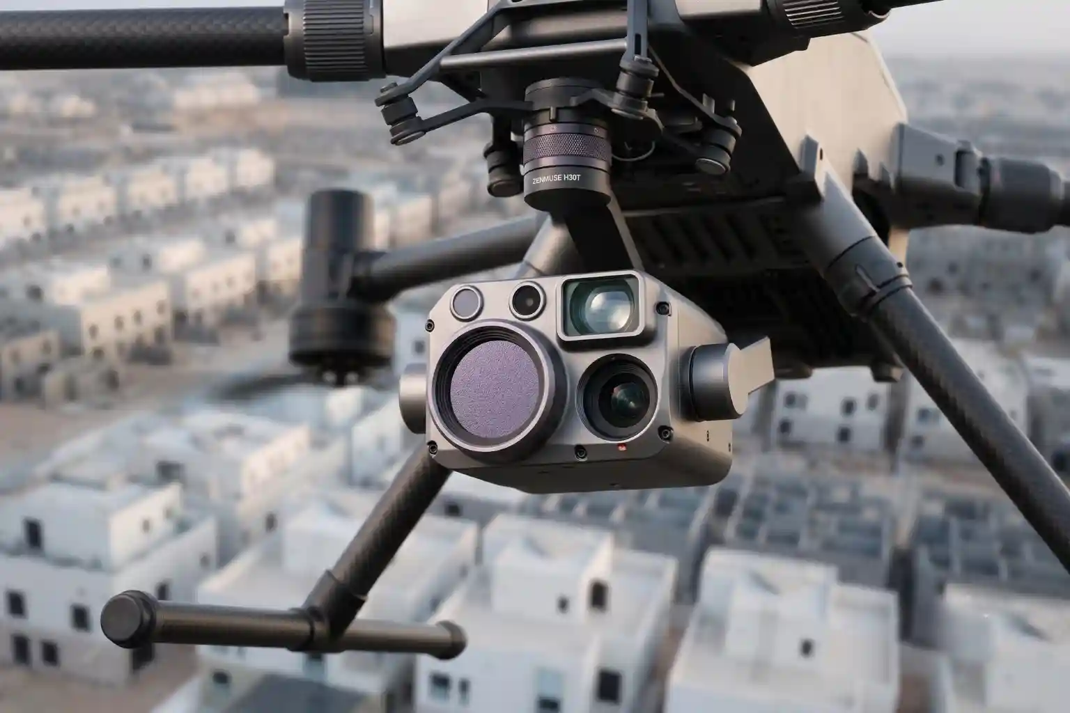
Deploying aerial thermal imaging across extended civil infrastructure requires a specialized flight platform engineered to maintain flight stability, long operational ranges, and precise sensor alignment under demanding coastal construction conditions.
Combining the heavy-lift capability of the DJI Matrice 400 with the multi-sensor architecture of the DJI Zenmuse H30T creates an automated aerial inspection solution tailored for linear canal environments.
Aircraft Flight Performance and Environmental Resilience
Executing continuous aerial surveys along an 11-kilometer water channel demands high flight endurance and environmental protection.
The DJI Matrice 400 features a maximum takeoff weight of 15.8 kg and supports a maximum payload capacity of 6 kg.
Operating with a single battery flight architecture, the aircraft achieves up to 59 minutes of flight time when carrying the Zenmuse H30T payload.
This extended flight duration allows field crews to cover multiple linear kilometers of retaining wall structures per flight cycle, minimizing battery swap intervals and operational downtime.
The aircraft is built with an IP55 ingress protection rating, safeguarding internal avionics against coastal salt fog, high humidity, and airborne dust particles typical of desert construction environments.
Designed to operate in temperatures ranging from -20°C to 50°C, the platform maintains steady flight performance during extreme summer heat along the Red Sea coast.
For safe navigation within complex construction sites where tall drill rigs, concrete placement cranes, and temporary piling rigs operate. The Matrice 400 integrates a multi-layered obstacle sensing system. This includes:
- 360° Rotating LiDAR: A horizontal rotating LiDAR unit capturing up to 520,000 points per second with a 100-meter detection range to construct real-time 3D point-cloud maps of surrounding obstacles.
- Six-Directional mmWave Radar: All-weather millimeter-wave radar providing obstacle sensing in low-visibility conditions such as morning sea fog, dust storms, or twilight lighting.
- Omnidirectional Vision Sensors: Full-color fisheye visual sensors providing spatial context to the flight controller.
Multi-Sensor Data Fusion via the Zenmuse H30T Payload
Capturing detailed thermal data alongside visual verification requires a multi-sensor payload. The DJI Zenmuse H30T combines four dedicated sensor modules into a single 920-gram IP54-rated gimbal assembly:
- High-Resolution Radiometric Thermal Imager: The thermal sensor utilizes an uncooled VOx microbolometer with a 1280 x 1024 resolution at 30 frames per second, offering a four-fold increase in pixel density compared to previous-generation 640 x 512 thermal sensors. With a Noise Equivalent Temperature Difference (NETD) of ≤ 50 mK at f/1.0, the sensor detects subtle surface temperature variations as small as 0.05°C. It operates across a spectral band of 8–14 μm and measures surface temperatures across a broad range from -20°C to 1600°C using adjustable High and Low Gain modes.
- 40MP Optical Zoom Camera: Houses a 1/1.8-inch CMOS sensor supporting 34× optical zoom and up to 400× digital zoom. This visual capability enables engineers to zoom in from safe standoff distances to examine structural cracks, joint degradation, or surface salt efflorescence on concrete quay panels.
- 48MP Wide-Angle Camera: Features a 1/1.3-inch CMOS sensor with a 24 mm equivalent focal length, capturing broad context images of excavation trenches and adjacent dewatering wells.
- 3,000-Meter Laser Rangefinder: Measures target distances up to 3,000 meters away with an accuracy of ±(0.2 m + distance x 0.15%), calculating exact geographic coordinates for detected anomalies.
The H30T supports side-by-side split-screen viewing and synchronized zooming on the remote controller display.
This feature allows operators to link visual light imagery directly with infrared thermal frames in real time, enabling immediate verification of whether a detected cold thermal anomaly corresponds to a physical surface feature (such as shadow or wet concrete) or a subterranean groundwater leak behind the quay wall.
Spatial Georeferencing and Cloud Data Integration
Converting raw aerial thermal footage into actionable engineering intelligence requires precise geospatial positioning and centralized data management.
The Matrice 400 incorporates dual-antenna Real-Time Kinematic (RTK) positioning receivers compatible with GPS, GLONASS, Galileo, and BeiDou satellite constellations.
RTK corrections provide centimeter-level positional accuracy (1 cm + 1 ppm horizontal, 1.5 cm + 1 ppm vertical), ensuring that every radiometric thermal image is recorded with exact spatial coordinates.
During inspection flights, the integrated laser rangefinder measures the precise distance between the aircraft payload and the retaining wall face.
The flight computer uses this range data to calculate the exact latitude, longitude, and elevation of target anomalies, automatically embedding geotags into the radiometric R-JPEG image files.
Field data automatically synchronizes with DJI FlightHub 2 cloud management software via the aircraft’s O4 Enterprise Enhanced Video Transmission System or optional 4G cellular connectivity modules.
Geotechnical engineers and site managers located at central offices can view live thermal streams, monitor real-time spatial annotations, and export geotagged thermal orthomosaics directly into GIS platforms and BIM models.
This automated cloud workflow ensures rapid communication between aerial inspection teams and ground maintenance crews, accelerating intervention timelines along the canal corridor.
Strategic Impact and Smart Infrastructure Integration
Maintaining retaining wall stability directly protects MARAFY’s 1.8 million square meters of built-up space for over 130,000 residents, alongside planned water taxis and transit links.
Adopting drone thermal inspection shifts civil asset management from reactive repair to predictive maintenance, detecting subterranean seepage early to prevent structural failure and lower long-term maintenance costs.
Consult with Our Experts
Get drones to move things fast and precisely in your infrastructure monitoring, dewatering tracking, and leak detection workflows. تحدث إلى خبيرنا to implement radiometric thermal inspection solutions for your civil projects.

 العربية