

Royal commissions, municipal authorities, and giga-project developers manage vast, highly interconnected urban ecosystems.
Historically, municipal asset records develop independently across departments, where surface transportation maps, building design drawings, underground utility schematics, and marine port surveys reside in separate databases.
This structural disconnect creates operational blind spots, delays engineering reviews, and leads to costly project redesigns during infrastructure upgrades.
Evolving beyond static two-dimensional documentation to dynamic, multi-modal reality capture establishes a unified three-dimensional spatial baseline across all physical environments.
Modern municipal management requires capturing data across four primary physical domains: aerial rights-of-way, terrestrial streetscapes, underground unvented utilities, and submerged water structures.
Capturing reality across these overlapping layers enables public-sector leadership to monitor asset conditions, verify contractor progress, and prioritize maintenance interventions on an objective spatial registry.
As city authorities scale smart-city initiatives, market analysis from Fortune Business Insights showing the global digital twin market reached SAR 91.80 billion in 2025 and is projected to expand to SAR 1,442.96 billion by 2034 at a 35.40% CAGR, driven by municipal authorities and royal commissions adopting connected digital twins for smart-city infrastructure and asset lifecycle management, highlights the global acceleration toward integrated geospatial governance.
Combining specialized aerial drones, mobile ground laser scanners, underground pipe crawlers, and subsea robotics bridges the gap between field reality and enterprise decision-making.
Cross-Domain Field Capture: Aerial, Terrestrial, Underground, and Subsea

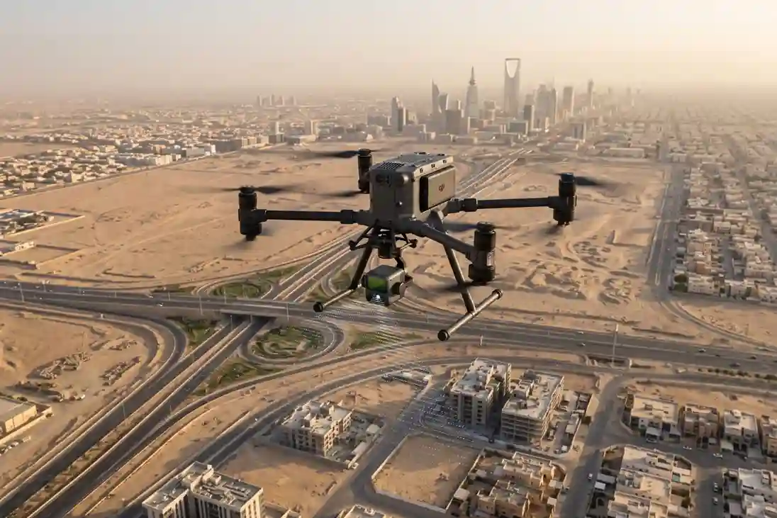
Achieving comprehensive digital twin coverage across an entire city requires matching specialized hardware platforms to specific environmental constraints and asset geometries. Deploying multi-domain robotics ensures that data collection proceeds seamlessly across open airspace, urban corridors, unvented underground pipes, and submerged waterfronts.
Aerial LiDAR and Terrestrial SLAM Surface Capture
Capturing large-area topography, linear transport corridors, building envelopes, and streetscapes requires balancing wide coverage with fine spatial resolution.
Aerial and ground-based mobile reality capture platforms operate together to map surface assets without creating gaps between roof structures, road pavements, and vertical building facades.
Wide-area topographic surveys and long utility corridor inspections deploy high-end multirotor aerial drones, such as the دي جي آي ماتريس 400 (إم 400). Flying along pre-programmed grid or linear flight paths at calibrated altitudes and flight speeds, the drone carries high-precision sensor payloads tailored for geometry and thermal measurement:
- High-Density Aerial LiDAR (DJI Zenmuse L3): The integrated LiDAR and photogrammetry payload emits laser pulses at rates up to 2,000 kHz, recording multiple return echoes per laser pulse. Penetrating gaps in dense vegetation canopies and shade structures, the sensor captures true ground surface elevations to generate sub-decimeter Digital Terrain Models (DTM) and Digital Surface Models (دي إس إم).
- High-Resolution Thermal and Optical Zoom (DJI Zenmuse H30T): Complementing LiDAR point clouds, the multi-sensor payload combines a high-magnification optical zoom lens with a 12801024 radiometric thermal imager. Aerial thermal surveys measure surface temperature variations across municipal districts, mapping urban heat anomalies, building envelope insulation loss, and irrigation leaks across public parks.
Confirming the rapid adoption of aerial laser scanning, market research from Fortune Business Insights highlighting that the global LiDAR drone market reached SAR 992.03 million in 2025 and is projected to expand to SAR 5,157.08 million by 2034 at a 20.10% CAGR, as aerial LiDAR surveys replace conventional land surveying to compress multi-kilometer corridor mapping timelines by up to 75% while capturing sub-decimeter terrain elevation models, proves the operational efficiency of drone-based LiDAR.
At street level, documenting narrow alleys, public building interiors, heritage facades, and shaded footpaths utilizes handheld and mobile Simultaneous Localization and Mapping (SLAM) laser scanners, such as the FJD Trion Laser Scanner.
Field technicians carry mobile SLAM units through facilities, capturing millions of 3D points per second while walking at normal speeds.
SLAM algorithms calculate the sensor’s exact position in real time using feature tracking across surrounding geometry, eliminating the need for stationary tripods, instrument setups, or satellite GPS signals inside indoor rooms.
Validating the growth of ground-based 3D reality capture, market analysis from Fortune Business Insights showing the global 3D scanning market reached SAR 21.53 billion in 2025 and is projected to reach SAR 62.44 billion by 2034 at a 12.56% CAGR, driven by engineering and construction teams adopting terrestrial SLAM laser scanners to accelerate indoor and facility as-built documentation by 60% over manual survey methods, highlights the speed advantage of mobile SLAM laser scanning.
Underground Confined-Space Inspection and Pipeline Traversal
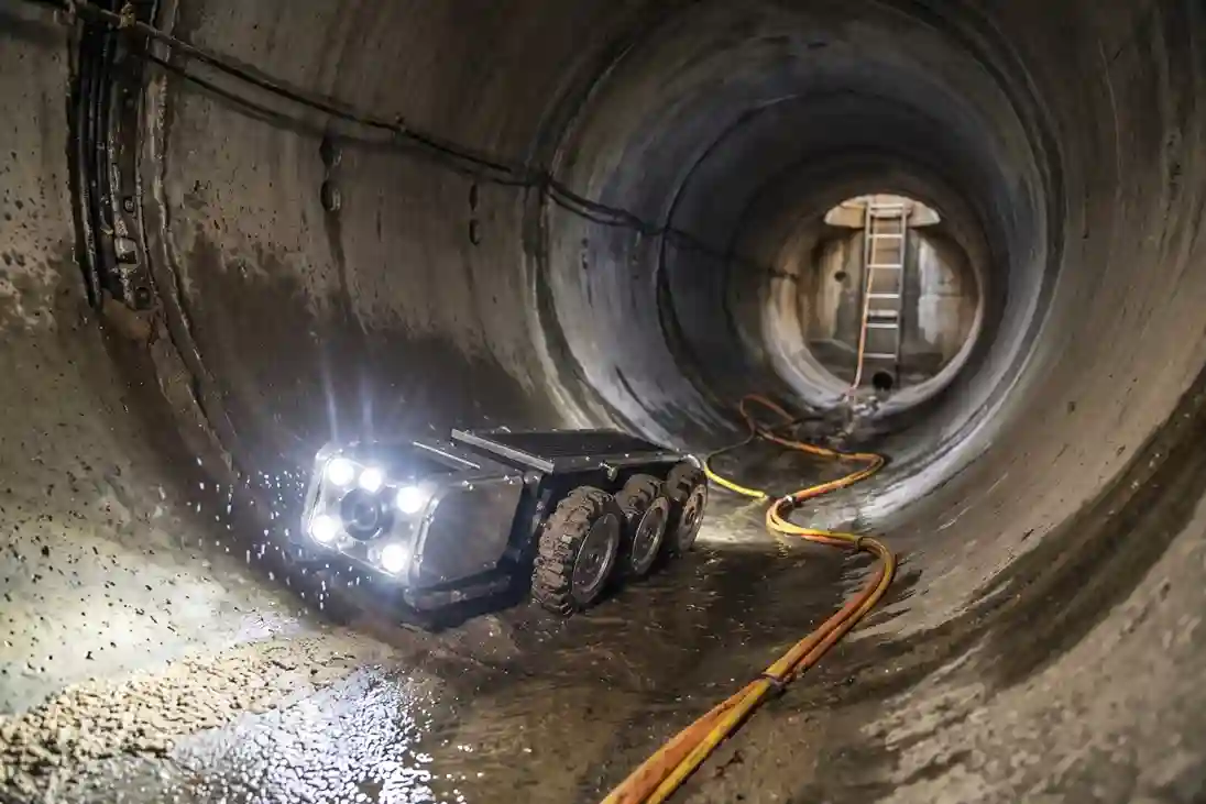
Underground utility networks, including gravity sewer lines, stormwater box culverts, and deep drop shafts represent critical infrastructure assets operating in dark, unvented, and hazardous environments.
Auditing these subsurface conduits requires matching robotic locomotion methods to internal pipe diameter, structural obstructions, and fluid levels:
- Small-to-Medium Drained Mainlines (<1.0m): Gravity sewer lines below 1.0m in diameter are audited using motorized, IP68 waterproof CCTV crawlers. Heavy-duty electric drive motors power interchangeable, textured wheel sets that maintain traction over slick concrete, vitrified clay, or PVC pipe inverts. A motorized pan-and-tilt optical camera head rotates 360 degrees and tilts 270 degrees to record high-definition video of lateral pipe connections, longitudinal cracks, and internal debris deposits. Heavy-duty power and data cables feed from a surface-mounted reel equipped with calibrated optical encoders that log linear travel distance along the pipe invert.
- Large-Diameter Trunk Mains and Culverts (1.0m): Unvented concrete trunk sewers, storm culverts, and vertical utility vaults with internal diameters of 1.0m or greater present thick sludge, standing water, and structural obstacles that immobilize wheeled vehicles. These large dry conduits are audited using collision-caged multirotor drones, such as the Nolvis X1. Enclosed within a lightweight carbon-fiber protective cage, the drone absorbs accidental impacts with concrete walls or hanging root masses without sustaining rotor damage. Operating in dark, GPS-denied environments, onboard optical-flow sensors, laser rangefinders, and distance sensors maintain flight stability along the pipe centerline. High-intensity 360-degree LED lighting arrays illuminate the crown, springline, and invert of the pipe, allowing onboard 4K optical sensors to record structural concrete spalling, exposed steel rebar, and joint displacements.
Quantifying the health and safety benefits of remote underground inspection, technical research published on ResearchGate establishing that deploying collision-caged drones and motorized CCTV crawlers for unvented underground pipe and culvert inspections achieves 100% direct personnel risk elimination by keeping workers out of toxic confined spaces, accelerates fault identification speed, and reduces asset maintenance downtime by 40% confirms the field safety and operational productivity of non-entry pipeline auditing.
Subsea Waterfront Structural Inspection and Sonar Profiling
Coastal industrial ports, commercial shipping berths, seawater intake channels, and waterfront promenades face continuous degradation below the waterline.
Submerged steel sheet piling, reinforced concrete quay walls, jetty trestles, and seawater outfall diffusers suffer from severe electrochemical marine corrosion, concrete spalling, rebar exposure, and seabed scour caused by tidal currents and vessel thruster wash.
Executing underwater structural audits without halting commercial shipping operations or exposing human divers to dangerous marine currents utilizes tethered industrial Remotely Operated Vehicles (ROVs), such as the QYSEA FIFISH NAVI W6. Powered by a 6-thruster Q-Motor array with active station-lock positioning, the vehicle maintains precise hovering stability close to submerged quay wall pilings in deep water.
Subsea ROVs carry integrated multi-sensor inspection payloads to evaluate submerged structural health:
- Dual 4K Optical Cameras and High-Intensity Lighting: Onboard low-light 4K camera sensors paired with a 12,000-lumen LED array record crisp optical video of surface pitting, marine bio-fouling, structural cracking, and exposed steel rebar in dark marine waters.
- 2D Multibeam Imaging Sonar: When water clarity drops due to suspended sediment or organic material, 2D imaging sonar emits acoustic pulses to penetrate turbid fluids. The sonar generates high-resolution acoustic profiles of submerged quay wall faces, detecting internal concrete voids, structural alignment shifts, and seabed scour pockets around piling foundations.
- Parallel Laser Scalers and Contact NDT Probes: Dual parallel lasers project calibrated millimeter reference dots onto submerged steel and concrete surfaces, allowing software algorithms to calculate exact crack widths and pitting depths from recorded footage. For metal loss evaluation, robotic manipulators extend Contact Ultrasonic Thickness (UT) probes against submerged steel sheet piles. Cavitation cleaning jets blast away marine growth at contact points, enabling the UT probe to measure remaining sound metal thickness with sub-millimeter precision (0.1mm).
Highlighting the operational and financial impact of subsea robotics, research published in Frontiers in Robotics and AI proving that replacing traditional commercial diving operations with subsea Remotely Operated Vehicles (ROVs) for underwater quay wall, outfall, and marine piling inspections reduces operational inspection costs by 50% to 90%, compresses survey time by 60%, and achieves 100% direct personnel risk elimination in hazardous marine currents underscores the technical superiority of tethered underwater vehicles.
Analytics, Data Processing, and Platform Integration
Collecting field data across aerial, terrestrial, underground, and subsea physical domains generates terabytes of raw, unstructured geospatial datasets.
Converting raw point clouds, high-resolution visual imagery, video feeds, and acoustic sonar logs into decision-ready spatial intelligence requires standardized processing pipelines, automated computer vision algorithms, and enterprise Geographic Information System (GIS) integration.
Multi-Sensor Data Ingestion and Point Cloud Registration
Raw field outputs from multi-modal capture devices arrive in various data formats: LAS/LAZ files from aerial LiDAR, E57 point clouds from terrestrial SLAM scanners, GeoTIFF orthomosaics from aerial photogrammetry, MP4 video logs from CCTV crawlers, and spatial acoustic files from subsea 2D multibeam sonars.
Unifying these multi-sensor outputs into a single coordinate reference frame requires a structured data registration pipeline:
- Georeferencing and Coordinate Alignment: Field survey teams establish spatial ground control points (GCPs) using Real-Time Kinematic (RTK) and Post-Processed Kinematic (PPK) GNSS positioning. All captured datasets align to a single national coordinate reference system (such as UTM Zone 37N or Zone 38N on the WGS84 datum).
- Point Cloud Registration: Co-registering aerial LiDAR point clouds from the DJI Matrice 400 with ground-level point clouds from the FJD Trion Laser Scanner utilizes Iterative Closest Point (ICP) alignment algorithms. The algorithm matches overlapping geometric features, such as building corners, curb edges, and structural columns blending aerial and ground point clouds into a seamless 3D spatial model without geometric offsets.
- Photogrammetric Mesh Reconstruction: Processing aerial photogrammetry imagery inside photogrammetry engines (such as DJI Terra) generates high-density 3D textured meshes, Digital Terrain Models (DTM), and orthomosaic basemaps for urban planning and engineering review.
Computer Vision Analysis and AI Defect Classification
Processing hundreds of hours of continuous sewer CCTV logs, confined-space drone footage (Nolvis X1), and underwater ROV video (QYSEA FIFISH NAVI W6) manually creates severe data bottlenecks and introduces reviewer subjectivity. Modern reality capture workflows apply deep learning neural networks to automate defect detection and spatial tagging:
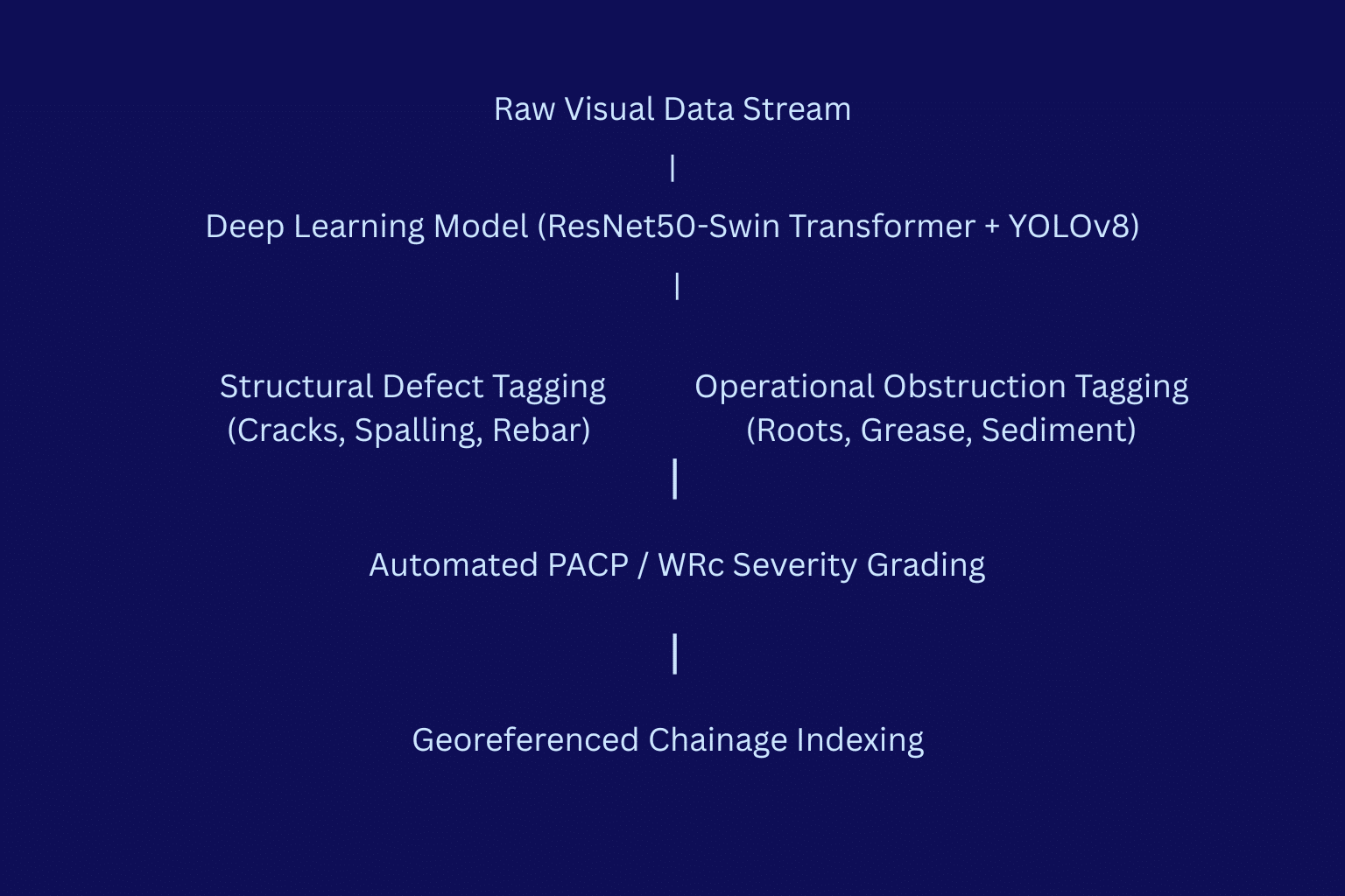
- Deep Learning Defect Detection: Computer vision algorithms process incoming video frames in real time, automatically identifying structural damage (longitudinal cracks, circumferential fracturing, concrete spalling, exposed steel rebar, and joint displacements) and operational obstructions (root intrusions, heavy grease deposits, and mineral encrustation).
- Automated Precision and Accuracy: Validating the reliability of machine vision models, technical research published on ResearchGate establishing that deploying hybrid deep learning models (ResNet50-Swin Transformer and modified YOLOv8) to process CCTV sewer inspection imagery achieves a 90.28% automated defect classification accuracy, drastically reducing manual video review time and increasing detection precision (mAP) to 81%, proves the technical reliability of automated image processing.
- Standardized Defect Coding: Machine vision models output bounding boxes around detected anomalies and assign standardized alphanumeric codes and numerical structural severity grades following frameworks like the Water Research Centre (WRc) Sewer Condition Classification or the Pipeline Assessment Certification Program (PACP). Structural condition scores range from Grade 1 (minor blemish) to Grade 5 (imminent pipe collapse).
Specialized Platform Analytics and Enterprise GIS Integration
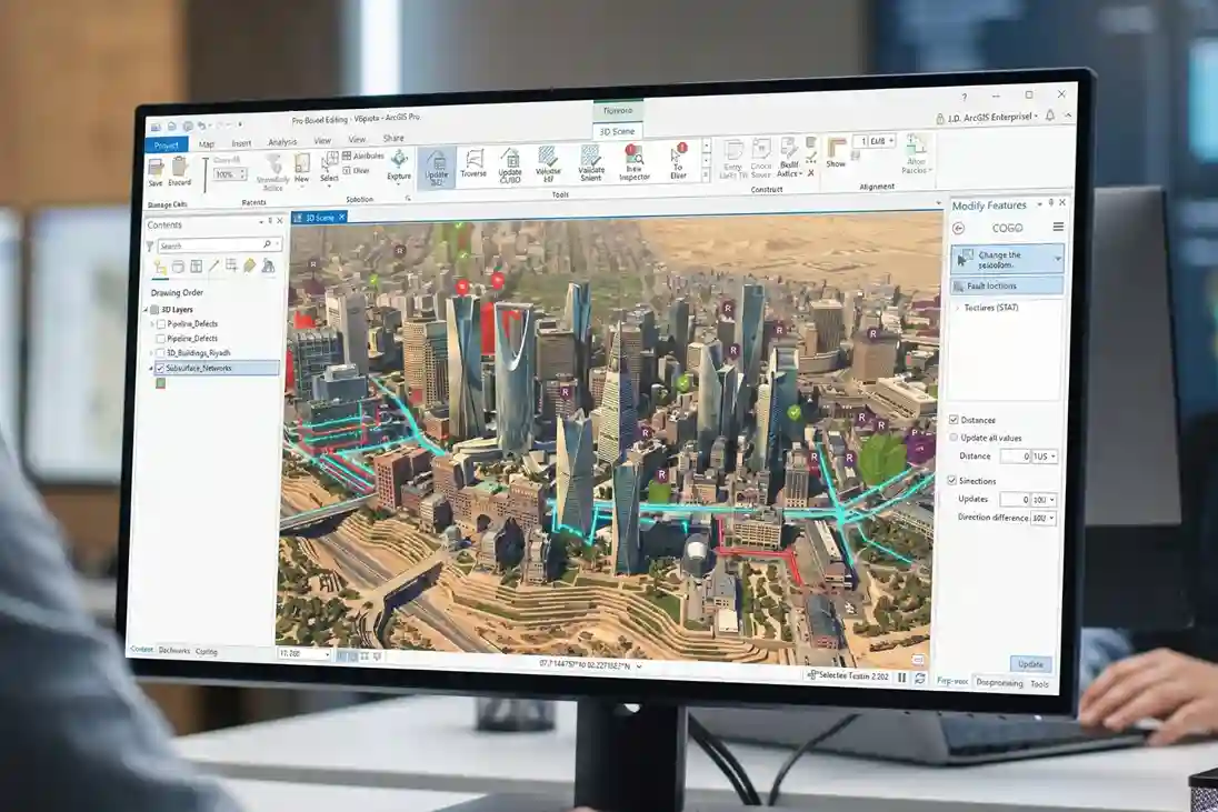
Once field data is processed and defects are classified, outputs are unified inside domain-specific software platforms before publishing to enterprise GIS environments:
- Terra ProgressX for Construction Progress: Ingests monthly drone orthomosaics and 3D point clouds to perform volume calculations for earthworks (cut/fill analysis), measure stockpile quantities, and track construction progress against as-designed BIM/CAD models.
- Terra SewerX for Utility Network Management: Links extracted high-resolution defect screenshots and video snippets directly to exact chainage coordinates (for example, a structural crack at 24.3 meters from Manhole MH-201). The platform generates standardized manhole-to-manhole condition reports and exports georeferenced spatial layers (GeoJSON and Shapefile formats).
- ArcGIS Enterprise Dashboard Integration: Processed spatial layers export to Esri ArcGIS Enterprise as hosted feature services, 3D scene layers, and web map applications. Connecting these spatial registries to Computerized Maintenance Management Systems (CMMS) automates maintenance workflows, routing verified Grade 4 and Grade 5 defect logs directly to maintenance contractors for trenchless repair execution.
Predictive Maintenance, Lifecycle ROI, and Operational Governance
Transforming isolated reality capture outputs into dynamic operational digital twins shifts municipal asset governance from reactive emergency repairs to data-driven predictive maintenance.
Combining spatial layers across aerial, terrestrial, underground, and subsea domains creates a single spatial registry that connects visual field findings directly to capital planning and daily operational workflows.
Dynamic Operational Digital Twins and CMMS Workflow Automation
Static three-dimensional models provide visual representation, but an operational digital twin must drive daily maintenance decisions across public infrastructure networks.
Importing georeferenced inspection deliverables, such as aerial LiDAR point clouds, terrestrial SLAM scans, sewer CCTV defect logs, and subsea NDT thickness measurements into Esri ArcGIS Enterprise and Computerized Maintenance Management Systems (CMMS) establishes an automated maintenance lifecycle:
- Automated Anomaly Routing: Deep learning computer vision algorithms and spatial processing platforms like Terra SewerX classify field defects using standardized PACP and WRc severity coding. Critical Grade 4 and Grade 5 defects automatically trigger localized maintenance flags inside municipal GIS dashboards.
- Closed-Loop Work Order Execution: CMMS integrations convert tagged defect logs and screenshot evidence directly into digital work orders. Maintenance contractors receive exact spatial coordinates and chainage locations (such as a structural pipe fracture located 18.4 meters downstream from Manhole MH-102 or subsea steel pitting along Berth 4), enabling targeted repairs without preliminary exploratory site visits.
- Verification Re-Scans and Asset History: Following maintenance interventions, post-rehabilitation robotic inspections capture updated visual and spatial logs. Storing time-stamped inspection records creates an auditable historical trail that tracks structural deterioration rates and verifies contractor work quality prior to final payment certification.
Subsurface Hydraulic Risk Mitigation and Infrastructure Lifespan Extension
Hidden subsurface structural failures inside gravity sewer networks and stormwater drainage channels create severe hydraulic risks that jeopardize surface urban infrastructure.
Structural cracking, joint displacement, and wall erosion lead to two primary hydraulic problems: groundwater infiltration and sewage exfiltration:
- Groundwater Infiltration Mitigation: High groundwater tables enter cracked gravity pipelines through open joints and fractured pipe walls. Uncontrolled infiltration increases hydraulic volume inside sewer networks, overloading municipal Wastewater Treatment Plants (WWTPs). Excess fluid volume significantly inflates operational pumping energy costs and chemical treatment expenditures across municipal treatment facilities.
- Sewage Exfiltration and Sinkhole Prevention: During dry periods, untreated sewage leaks out of cracked pipe walls into surrounding sub-base soil matrices. Continuous exfiltration contaminates local groundwater tables and washes away fine soil particles around the pipe foundation, forming subterranean soil voids. Over time, unmonitored subsurface soil erosion causes sudden pavement collapses and catastrophic urban sinkholes along active street corridors.
Centralizing multi-domain robotic inspection records inside dynamic spatial registries mitigates these systemic risks.
Engineering research published on ResearchGate showing that transitioning from reactive pipe repairs to proactive digital twin asset management prevents undetected exfiltration and groundwater infiltration, avoiding secondary soil erosion, road collapses, and unnecessary wastewater treatment loads across municipal networks confirms the necessity of continuous subsurface monitoring.
Quantifiable Lifecycle ROI and Standardized Spatial Governance
Fusing multi-domain reality capture data with localized trenchless rehabilitation methods delivers significant capital cost savings compared to traditional open-cut infrastructure replacements.
Open-cut utility replacements require heavy earthmoving machinery, asphalt cutting, traffic diversions, utility line relocations, and prolonged construction schedules that cause major commercial disruption.
Trenchless rehabilitation methods, such as Cured-In-Place Pipe (CIPP) lining, mechanical spot repairs, and subsea cathodic protection retrofits utilize internal condition data to restore structural capacity without surface excavation.
Environmental and lifecycle cost evaluations published on ResearchGate proving that fusing digital pre-rehabilitation pipe condition data with trenchless rehabilitation methods reduces overall pipeline life-cycle costs by an average of 56% (and up to 69% across standard mainline diameters) compared to open-cut replacement, while lowering greenhouse gas emissions by 54% to 77% demonstrate the financial and environmental return of digital pre-inspection workflows.
Quantifying long-term financial returns across multi-asset portfolios, technical research published on ResearchGate demonstrating that fusing multi-domain reality capture data (aerial LiDAR, terrestrial laser scans, sewer CCTV logs, and subsea NDT measurements) into a unified 3D operational digital twin enables predictive maintenance frameworks that reduce overall asset lifecycle repair costs by 35% and extend infrastructure operating lifespan by up to 25 years compared to reactive replacements confirms the financial viability of multi-modal robotics.
Establishing a standardized spatial governance model aligns municipal operations directly with Saudi Arabia’s Vision 2030 and Quality of Life Program objectives. Implementing strict data ownership, national cybersecurity controls (NCA ECC), and SDAIA personal data protection rules ensures that sensitive urban spatial data remains secure while powering smart-city operations.
Maintaining an auditable, time-stamped digital record across aerial, terrestrial, underground, and subsea assets ensures that public infrastructure across the Kingdom is monitored, rehabilitated, and governed on an accurate spatial foundation throughout its operational lifespan.
Consult with Our Experts
Streamline your city-scale reality capture programs, multi-modal drone operations, subsea ROV surveys, and digital twin integrations.
Contact our specialist to build unified digital twin solutions for your infrastructure assets.

 العربية