Real-Time Traffic Management With Drones to End Road Jams

In rapidly growing cities like Riyadh and Jeddah, traffic congestion is more than a simple daily annoyance. It represents a significant drag on economic productivity and a hurdle to improving the general quality of life. The primary issue with current infrastructure is that most traffic lights operate on static, fixed timers. These systems are unable […]
Drone Defense Overview: Exploring the Drone Detection Solution

The sky is becoming a busy place as commercial drones are now used for everything from delivery to photography. While most are harmless, the proliferation of these machines creates new risks for critical infrastructure like power plants and large public events. Traditional security cannot stop a threat that comes from above. This is why modern […]
DJI Mavic 3: The Portable Work Drone

For years, professional drone operations were synonymous with large vans, heavy equipment cases, and multi-person crews. However, as we move through 2026, the industry has realized a vital truth: drones alone are no longer enough for operational purposes. While the aircraft gets you into the sky, reliable software is needed to process the large amounts […]
Drone Battery Storage & Safety: The Essential Guide

In recent years, lithium-ion battery incidents have surged globally, with reports showing a 17% increase in related fires due to mishandling during storage and charging. A single lithium battery failure can trigger “thermal runaway,” a catastrophic chain reaction where temperatures spike from 100°C to over 1,000°C in seconds. Alarmingly, over 50% of these fires occur […]
How to Spot Unknown Drones In Your Facilities in Real-Time

For modern oil and gas refineries, the threat from unauthorized drones is no longer theoretical. Whether it is industrial espionage, illegal photography, or potential physical interference, an unknown UAV in your airspace is a major security breach. However, refineries face a delicate challenge: many traditional drone defense systems use high-power radio signals that can interfere […]
Nolvis X1: Redefining the Standard for Confined Space Inspection

In the heavy industrial landscape, the most critical assets, such as storage tanks, massive boilers, underground mine shafts, and ship cargo holds, are often the most dangerous to inspect. Traditional manual methods require scaffolding, specialized high-risk permits, and placing human lives in dark, dusty, and oxygen-depleted environments. The Nolvis X1, developed by Nolvis Corporation in […]
Coastal LiDAR: Precision Mapping for Saudi Arabia’s Environmental Restoration

The coastal ecosystems of the Arabian Gulf have historically faced immense ecological pressure, particularly following the significant environmental disruptions of the early 1990s. Recognizing the critical need for sustainable recovery, we conducted a coastal restoration drone LiDAR survey to provide the high-fidelity data necessary for environmental remediation. This mission was not merely about mapping; it […]
Airins’ Autonomous Solutions: Transforming Environmental Monitoring

As we move through 2026, the global push toward Net-Zero and environmental accountability has reached a critical inflection point. Traditional monitoring relying on manual sampling or static sensors is no longer sufficient to meet the speed and precision required by modern regulatory frameworks like OGMP 2.0. The “blind spots” in industrial facilities and aquatic ecosystems […]
How Quadruped Robot Inspects Extreme Industrial 24/7

As Saudi Arabia accelerates toward Vision 2030, the Kingdom’s energy sector is undergoing a profound metamorphosis. Leaders like Saudi Aramco and SABIC are moving beyond traditional maintenance toward a future defined by digital twins and unstaffed facilities. However, the bridge between a virtual model and a physical refinery is data—specifically, high-fidelity, real-time data collected from […]
The EMAT Test: High-Precision NDT Without the Mess
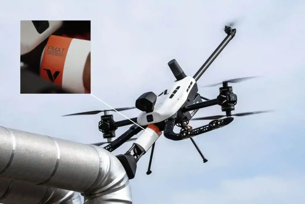
For decades, Ultrasonic Testing (UT) has been the gold standard for verifying asset integrity, yet it remains plagued by operational “friction”. Traditional piezoelectric transducers require a liquid coupling medium, such as water or gel o transmit sound waves into a material. This necessitates extensive surface preparation, including the removal of coatings, rust, and dirt, followed […]
