Seafloor Mapping
Protecting a coastal ecosystem requires a complete understanding of its underwater terrain.
Before any conservation plans or low-impact tourist activities can begin around Laheq Island, environmental teams must map the layout, underwater trenches, and shallow slopes of the seabed.
This structural map helps scientists understand exactly where marine habitats are located and how the underwater landscape shapes local sea currents.
Mapping the seafloor in this region requires extreme care. The Red Sea contains one of the longest continuous coral reef systems on Earth, supporting a sustainable tourism industry valued at SAR 44.3 billion annually.
Traditional boat-based sonar mapping often lacks the detail needed for shallow reef zones, and sending human divers into tight underwater spaces introduces safety risks and the potential for accidental coral damage.
To safely navigate these delicate environments, the project uses the QYSEA FIFISH V-EVO underwater ROV (Remotely Operated Vehicle).
A key feature of this platform is its 360-degree maneuverability. The drone uses an advanced thruster system that allows it to tilt, roll, and flip upside down in any direction.
This extreme agility allows the vehicle to swim safely through tight spaces in coral reefs and map complicated vertical seafloor walls without touching or damaging the fragile ecosystem.
Biodiversity Mapping and Documentation
Beyond mapping the physical shapes of the seafloor, the field team uses the underwater drone to run comprehensive marine biodiversity audits.
Documenting the specific plants and animals living around the island is vital for its long-term protection.
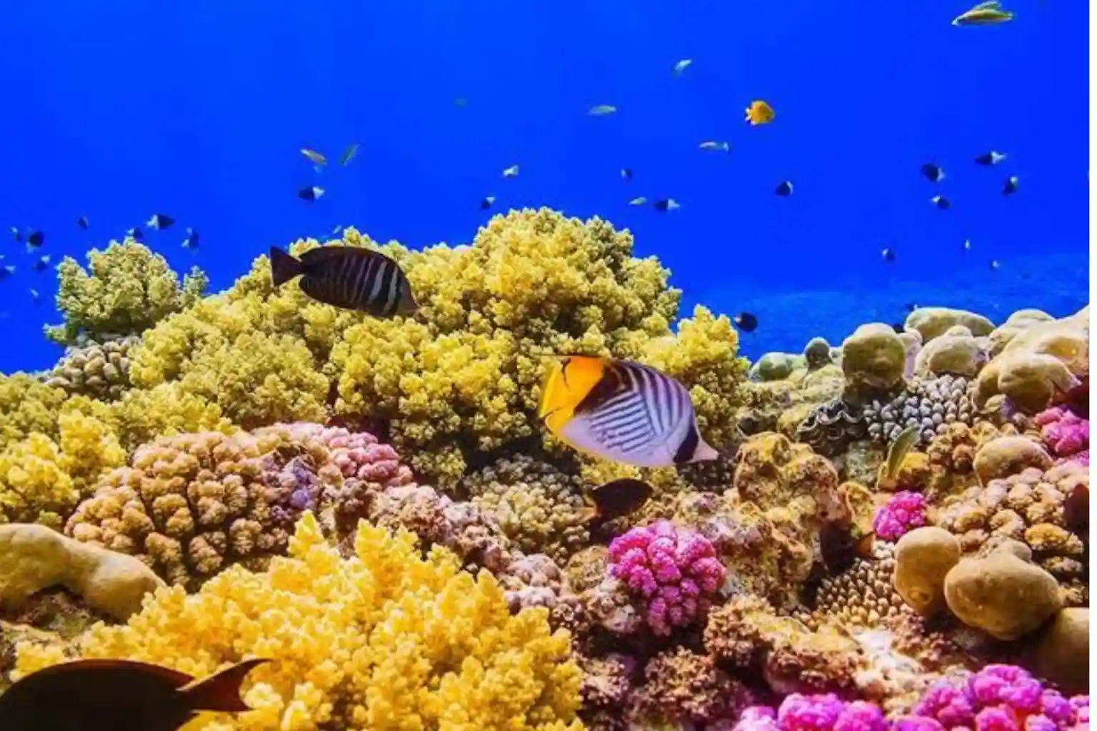
Globally, coral reefs are incredibly precious habitats. While they cover less than 0.2% of the entire ocean floor, they support 25% to 30% of all known marine species worldwide.
The Red Sea is particularly important because it boasts 6% endemic coral species, meaning these specific corals are found nowhere else on the planet.
To collect clear visual proof of these species without disturbing the habitat, the QYSEA FIFISH V-EVO relies on advanced digital tools and automated systems.
Establishing Biological Baselines for Isolated Coral Communities
To protect an ecosystem effectively, scientists must first understand its baseline condition. This means creating an exact inventory of every coral colony, fish population, and invertebrate community surrounding Laheq Island.
Traditional methods of cataloging these species rely on human divers who swim along a fixed rope line with waterproof clipboards.
This manual approach is slow, limited by how long a diver can breathe underwater, and often inaccurate because many fish species swim away the moment they hear the loud bubbles produced by scuba equipment.
Using an uncrewed vehicle changes this dynamic entirely. The compact drone moves quietly through the water without producing air bubbles, allowing it to approach marine life without triggering a flight response.
This enables the collection of natural, unbiased data on animal behavior and population density.
Furthermore, because the Red Sea contains unique 6% endemic coral species, field teams must document the exact health of these rare structures.
Corals are highly sensitive to changes in water temperature and sedimentation. By using the drone to capture repeatable, high-resolution visual records of the exact same coral formations month after month, marine biologists can spot early signs of stress, algae overgrowth, or tissue damage.
This permanent digital record replaces human guesswork with verifiable visual proof, giving conservation teams the data they need to act before a reef community suffers permanent loss.
Overcoming Underwater Optical Distortions with Real-Time AI Processing
Capturing clear, useful footage underwater is incredibly difficult due to the natural physics of water.
Sunlight scatters and loses its color intensity just a few meters below the surface, turning everything into a dull blue or green hue.
At the same time, ocean water is rarely completely clear. It is filled with “marine snow,” which is a thick mix of floating dirt particles, dead organic matter, and tiny drifting plankton.
When a standard camera turns on its lights in dark water, these floating particles reflect the light directly back into the lens, creating a blurry, washing-out effect similar to driving through a thick fog with your high beams on.
The QYSEA FIFISH V-EVO solves this fundamental environmental obstacle using automated AI Plankton Filtering.
As the drone swims through a murky reef zone, its internal computer processor analyzes the incoming video feed pixel by pixel.
The smart AI filter identifies these tiny, reflecting floating particles and digitally removes them from the operator’s live screen in real-time.
This processing cleans up the image instantly, revealing the true shapes and colors of the hidden environments below.
To make this clear view scientifically valuable, the drone pairs its filtering software with a High-Speed 4K Camera that shoots at 60 frames per second.
Standard underwater cameras shooting at lower frame rates produce blurry images whenever the drone moves quickly or when a fast fish darts across the frame.
Shooting at 60 frames per second means the camera captures twice as many visual frames per second as a normal television broadcast.
This high speed freezes the motion of quick-moving marine animals, like reef fish, hunting jacks, and sea turtles, ensuring that every frame remains perfectly sharp and free of motion blur.
Researchers can pause the recorded 4K video at any exact second to count scales, identify specific species markings, or measure animal body lengths with absolute clarity.
Tracking and Precision Observation of Mobile Marine Species
Documenting a marine habitat requires more than just taking still photographs; it requires tracking how animals interact with the reef over time.
However, ocean waters are constantly moving due to tides, waves, and deep currents. If a drone operator tries to watch a specific animal, they must constantly adjust the controls to fight the moving water, which shakes the camera and makes it easy to lose sight of the subject.
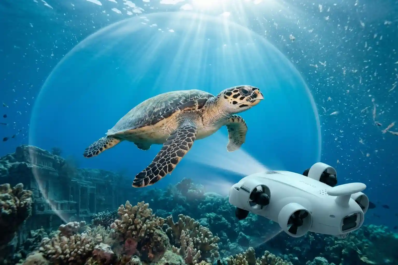
The system bypasses this manual struggle through its AI Vision Subject Lock system. When an operator spots an important indicator species, such as a sea turtle or a rare predatory fish.
They simply tap the object on their control screen. The drone’s internal vision software immediately locks onto the shape, color, and texture of that specific animal.
Once locked, the drone’s internal computer takes over the thrusters completely. It automatically calculates the movement of the water and the speed of the animal, adjusting its motors to hover and stay focused on that exact subject without any manual steering required.
This automated tracking allows the drone to follow mobile species smoothly as they move through the reef.
Because the vehicle possesses 360-degree maneuverability, it can tilt its body completely vertical, roll sideways, or spin in place while keeping its camera locked on the target.
If a fish swims downward into a deep coral trench, the drone can tilt straight down and follow it smoothly.
This agility ensures that the camera maintains an uninterrupted view of the animal from optimal angles.
By automating the flight controls, the system allows the human operator to focus entirely on scientific observation, ensuring that no critical biological details are missed during the audit.
This highly detailed method of tracking directly supports global conservation goals, helping protect the dense biological networks that allow global coral reefs to support up to 30% of all known marine species despite their small geographic footprint.
Balancing Leisure and Conservation
The raw visual data and spatial maps gathered by the underwater drone do not simply sit on a storage drive. Instead, they serve as the foundational blueprint for the island’s master layout plan.
By taking the high-resolution 4K video records and the exact structural maps of the seabed, project planners can make highly calculated decisions about where human activities can happen and where nature must be left completely untouched.
This spatial planning ensures that economic goals and environmental safety work together rather than against each other.
Zoning the Marine Environment for Eco-Tourism
When creating a luxury destination, developers must carefully decide where to place docks, swimming zones, boat paths, and snorkeling trails.
Without detailed data, a boat might drop its heavy metal anchor directly onto a centuries-old coral head, shattering a habitat that took hundreds of years to grow.
Similarly, if swimming areas are placed too close to shallow reefs, tourists might accidentally step on and kill sensitive marine organisms.
To prevent these issues, planners load the drone’s seafloor maps into geographical information systems (GIS).
The software highlights areas that are completely made of bare sand, rubble, or open water, separating them from live coral matrices.
These sandy spaces are officially marked as low-risk zones where developers can safely build floating docks, clear swimming paths, and establish designated anchoring areas for watercraft.
By separating human water tracks from live reef habitats, the project ensures that boat traffic and recreational swimming do not cause structural harm to the ecosystem.
This careful planning allows the development to welcome guests safely while fully supporting and protecting the region’s sustainable tourism economy.
Guests can enjoy the marine environment with the peace of mind that their presence is not degrading the natural beauty they came to see.
Establishing Digital Conservation Boundaries for Endemic Marine Biota
For the zones that host dense populations of wildlife, the drone data is used to draw strict, invisible protection borders.
The underwater vehicle logs exact GPS coordinates whenever it encounters rare habitats or critical biological nursing grounds.
Any section of the reef that contains the Red Sea’s unique 6% endemic coral species is immediately closed to the public.
These areas are designated as high-protection zones, meaning no boats are allowed to pass through, no fishing can take place, and no swimmers may enter the water.
These digital boundaries create safe sanctuaries where marine life can grow, feed, and reproduce without human interference.
Because these isolated sanctuaries remain healthy, they act as biological engines that supply young fish, coral larvae, and other organisms to the surrounding waters.
This localized protection is highly significant on a global scale. Protecting these specific, highly concentrated biological zones directly safeguards the complex underwater networks that allow global coral reefs to support the known marine species despite covering such a tiny fraction of the ocean floor.
The drone data allows scientists to establish these boundaries with millimeter accuracy, ensuring that not a single patch of rare coral is left exposed to accidental damage.
Creating Remote Observation Feeds for Public Education
True conservation requires more than just locking an ecosystem away from the public; it also requires teaching people about its value.
When an area is locked down for scientific protection, the public usually loses the ability to see it.
The drone system solves this problem by turning its underwater inspections into educational tools.
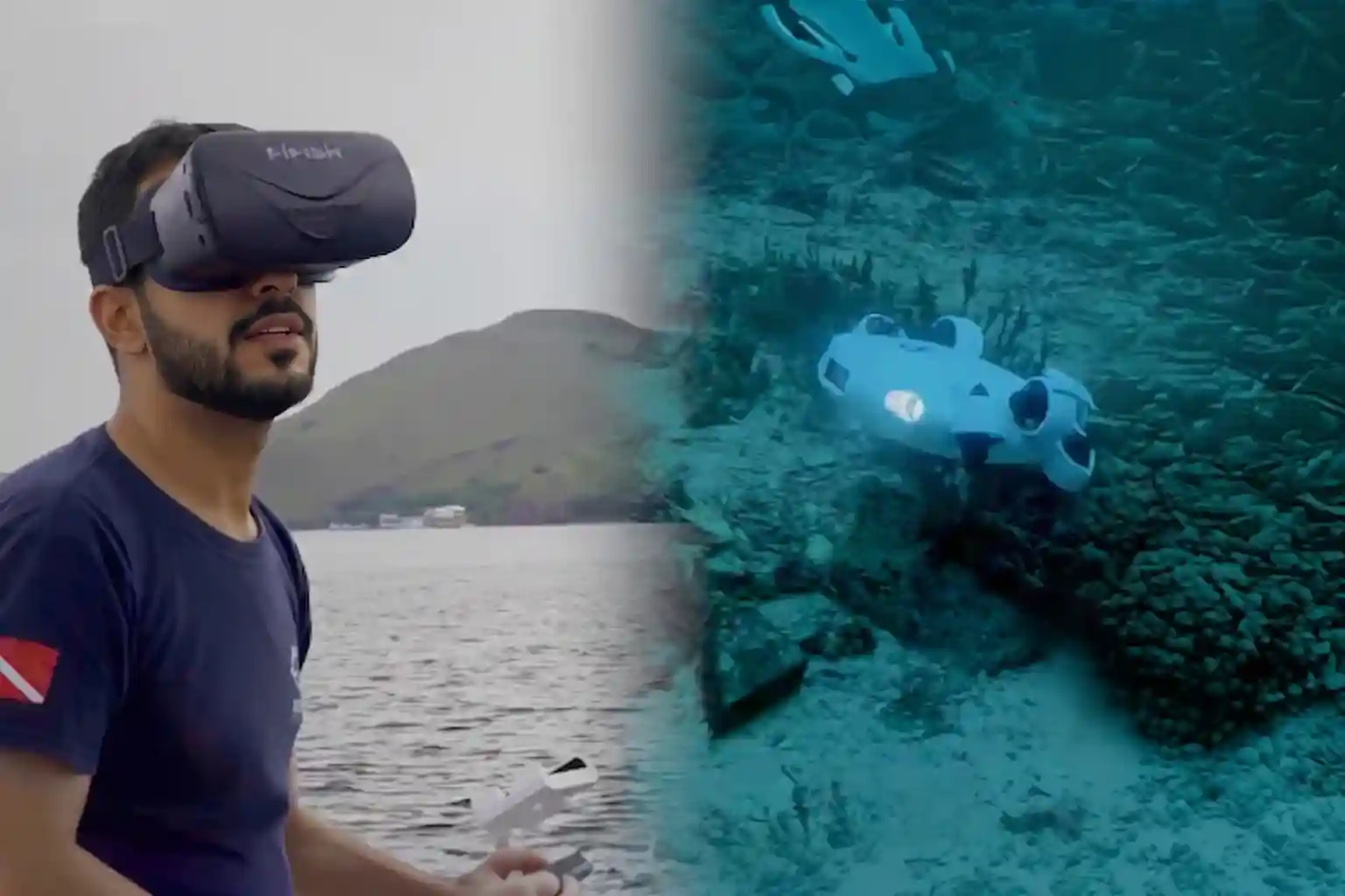
The high-speed 4K video libraries and live sensor feeds collected by the vehicle are compiled into digital catalogs and virtual reality experiences.
These high-resolution feeds allow resort guests, students, and global researchers to look directly into the most sensitive coral sanctuaries without ever getting wet.
People can observe the natural behavior of rare fish, watch sea turtles feed, and inspect the complex geometric shapes of the reef through digital screens installed on the land.
This setup fulfills both the observation and preservation goals of the development. It provides a profound, memorable educational experience that highlights the importance of protecting marine biota while keeping human feet, cameras, and waste completely out of the fragile underwater environment.
By replacing physical presence with high-fidelity digital access, the project maintains an absolute balance between modern leisure and permanent environmental protection.
Securing The Environment
Protecting vulnerable marine ecosystems requires precise, high-resolution data that traditional observation methods cannot provide.
Switching to ROV data collection replaces guesswork with clear visual evidence, keeping your environmental records accurate and your conservation efforts fully verified.
Consult with our expert to integrate advanced QYSEA ROV workflows into your next marine biodiversity or coastal infrastructure project.

