The international construction sector loses an estimated over SAR 6 trillion annually due to low efficiency and structural execution delays, with global sector productivity expanding at a low rate of just 0.4% per year.
Remote, high-profile megaprojects have zero tolerance for these timeline extensions.
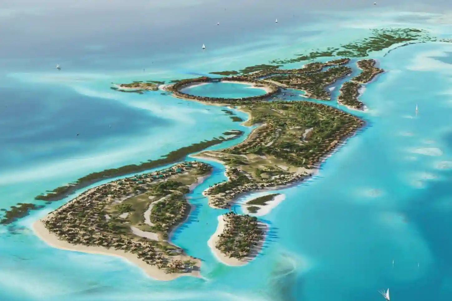
A prime example is the 400-hectare luxury development on Laheq Island, which is a highly complex, 800-meter overwater circular structure known as “The Ring”.
When building sophisticated assets in remote coastal environments, traditional progress tracking methods fall short.
Relying on slow manual field inspections or basic aerial photography makes it incredibly difficult to catch structural misalignments early.
Without real-time visibility, minor placement errors compound quickly, driving up corrective costs and delaying downstream development.
The Complex Realities of Remote Island Logistics and Modular Delivery
To protect the island’s fragile marine ecosystems and accelerate deployment, developers are shifting away from traditional on-site building methods.
Instead, the project relies heavily on off-site volumetric modular techniques, which compress end-to-end project timelines by 20% to 50%.
However, managing logistics for a remote island infrastructure footprint introduces rigid operational boundaries.
Because components are manufactured thousands of kilometers away from the final destination, any breakdown in the coordination between factory production and site assembly can completely derail a project’s budget.
The Mechanics of Timeline Compression via Volumetric Modular Building
Traditional construction requires a linear schedule where foundations must be completely cured before structural walls or framing can begin on-site.
In contrast, volumetric modular construction relies on parallel processing.
While marine engineering crews are working on Laheq Island to install the foundational marine piles for “The Ring”, manufacturing plants are simultaneously fabricating the fully enclosed, 3D geometric timber frames in a controlled factory environment.
This parallel workflow is the direct cause of the 20% to 50% timeline acceleration seen in modern megaprojects.
However, this compressed schedule creates a zero-tolerance window for delivery delays.
Volumetric modules are highly sensitive to site readiness. If the overwater foundations on the island deviate from the architectural specifications by even a few millimeters, the pre-fabricated modules cannot be locked into place.
Because an island has limited storage space, arriving watercraft cannot simply unload modules to sit on the shore, meaning that any foundation error immediately forces transport ships to idle in open water at a massive daily cost.
Environmental Footprint Reduction and Habitat Protection

Building a luxury destination within a highly protected environment requires minimizing the physical footprint of the construction process itself.
Utilizing prefabricated modular frameworks addresses this requirement directly by reducing total supply chain vehicle movements by 56% compared to traditional construction methods.
In a standard construction project, thousands of individual truck or barge deliveries are required to transport loose raw materials like sand, aggregate, liquid concrete, bricks, and steel beams.
For an island ecosystem, this volume of traffic results in continuous marine disruption, including elevated underwater noise that impacts marine wildlife, increased risks of fuel spills, and potential anchor damage to sensitive barrier reefs.
By moving the bulk of material fabrication off-site, the project limits deliveries to completed, ready-to-install structural units.
This reduction in vehicle and vessel transit prevents the need for massive material staging yards on the island, protecting local mangrove systems from being cleared and preventing widespread soil compaction from heavy machinery.
The Vulnerability of Prefabricated Supply Chains
Despite the clear efficiency gains, a modular supply chain is highly vulnerable to sequencing errors.
When building complex geometric structures over water, modules must arrive and be installed in a strict, chronological order.
If a single timber villa module is damaged during sea transit, or if it is misplaced within the island’s temporary staging zone.
The entire assembly line stalls because subsequent components cannot be positioned without the underlying support structure in place.
Traditional site inventory management relies on manual gate logs, paper manifests, and physical ground inspections.
On a remote 400-hectare island, these manual processes are too slow to keep pace with a rapid modular schedule.
By the time a ground team manually identifies that a delivery vessel has unloaded the wrong component, or that a structural element has been placed in the wrong assembly sector, hours or days of construction time are lost.
Managing this high-stakes logistics pipeline requires a continuous, bird’s-eye view of the landscape to verify that every component matches the digital inventory before it is moved to the installation line.
Building an Absolute Digital Twin for Real-Time Progress Verification
To manage tight assembly schedules and maintain strict control over remote project boundaries, field teams deploy the compact DJI Mavic 3 Enterprise (M3E) drone directly across active construction zones.
This aerial system acts as a digital bridge between off-site fabrication plants and the physical realities of the island landscape.
The drone utilizes a specialized hardware configuration consisting of a built-in mapping camera paired with a top-mounted RTK Module to capture highly accurate geospatial data.
This configuration overrides standard GPS satellite drift, allowing project managers to build a reliable virtual replica of the project’s physical assets.
Capturing Centimeter-Level Field Data Without Ground Distortion
Standard commercial drones rely on internal GPS receivers that can drift by several meters depending on atmospheric conditions and satellite geometry.
For a precise architectural layout like Laheq Island’s overwater structures, a variance of a few meters can cause components to misalign completely.
The DJI Mavic 3 Enterprise resolves this issue by using its screw-on RTK module to constantly communicate with local ground base stations.
This real-time link corrects satellite signals instantly, stamping every captured photo with coordinates that are accurate down to the centimeter.
Equally important to this data pipeline is the drone’s 20-megapixel mechanical shutter.
Traditional electronic shutters capture images line-by-line while the drone is moving, which introduces a “rolling shutter” warping effect that distorts the shapes of physical objects in the photo.
The DJI Mavic 3 Enterprise’s mechanical shutter opens and closes instantly, freezing the image in place even while the drone flies at high speeds.
This capability ensures that the geometric shapes of timber frames, foundation grids, and coastal retaining walls are captured with zero visual distortion.
By gathering unwarped, hyper-accurate spatial data, engineering teams eliminate the human logging errors and planning blind spots that historically derail multi-tier projects.
In fact, industrial research indicates that 73% of project troubles on major global developments stem directly from poor site execution and planning inefficiencies rather than external regulatory shifts.
Frequent drone data collection replaces guesswork with absolute geometric certainty.
Generating the 3D Reality Mesh for Overwater Structural Alignment
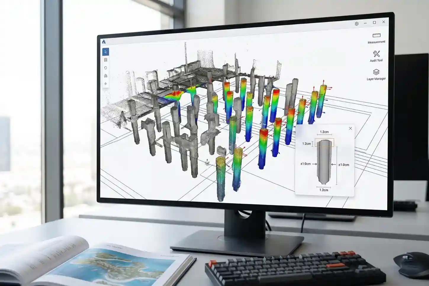
Once the drone finishes flying its pre-programmed grid patterns over the island, the gathered image packages are uploaded into specialized photogrammetry software.
The software analyzes thousands of overlapping pixels across the images to calculate a dense point cloud, which is then converted into a highly detailed 3D digital twin of the landscape.
This digital twin updates progressively with each new flight, capturing the exact, as-built state of the island on a weekly or daily basis.
For Laheq Island’s flagship feature, the 800-meter overwater circular ring structure.
This 3D model is vital. Marine engineering crews must drive support piles into the seabed to hold the elevated villas and public walkways.
Before the heavy, prefabricated timber structures arrive via barge from off-site factories, managers can overlay the drone-generated 3D digital twin directly on top of the original digital design blueprints.
This automated comparison functions as a virtual alignment audit.
If an overwater foundation column has shifted by even a minor margin during underwater installation, the software flags the physical variance instantly.
Engineers can adjust the connection brackets or modify the assembly sequence digitally before the prefabricated assets are shipped, avoiding incredibly expensive field alterations on a remote island shore.
Reclaiming Wasted Capital Through Progressive Site Audits
The real-world financial value of integrating drone-driven digital twins extends far beyond basic field progress tracking.
On a global scale, structural execution gaps and low operational efficiency cause the international construction industry to lose trillions annually in unrealized financial value.
Much of this waste is driven by rework, the process of demolishing and rebuilding structures because components were installed incorrectly due to poor site coordination.
Progressive digital twin tracking actively combats this productivity drain by creating a continuous, transparent ledger of site activities.
Staging yards can be monitored automatically to verify that arriving modular units are stored in the correct sequence, preventing double-handling and reducing machinery transit wear.
Industry metrics confirm that shifting project analysis and optimization to the early phases of development pays massive dividends for asset owners.
Prioritizing detailed digital site assessments during the pre-construction and active building phases yields a proven Net Present Value (NPV) uplift of 20% or more of the total installed cost by preventing material waste and schedule slippage.
For a multi-billion dollar coastal megaproject, this data-driven optimization protects downstream capital and ensures long-term operational success.
Secure Your Remote Infrastructure Timelines
Relying on slow field tracking or unverified manual reporting introduces unnecessary risks to remote island developments.
Transitioning to automated remote spatial audits ensures off-site manufactured components align perfectly with real-world terrain conditions from the moment they arrive at the dock.
This proactive verification process keeps the infrastructure timelines secure, logistics optimized, and downstream budgets completely intact.
Consult with our expert to integrate advanced digital twin and drone logistics management workflows into your next infrastructure project.

