Saudi Arabia’s Mining Sector and Economic Diversification
Saudi Vision 2030 outlines the Kingdom’s strategy to reduce its dependence on oil by strengthening the mining sector. As the third pillar of Saudi Arabia’s economic transformation, mining aims to become a significant contributor to the GDP, with goals to increase its economic output from $17 billion to $75 billion by 2035. The Kingdom boasts an impressive wealth of mineral resources, including gold, phosphate, bauxite, and copper. Unlocking these resources efficiently requires innovative solutions, and satellite imagery emerges as a powerful enabler of this progress.
The introduction of satellite imagery in modern mining aligns with the Kingdom’s ambitions, offering an efficient, cost-effective way to explore, monitor, and manage large-scale mining operations. By combining remote sensing with advanced technologies like artificial intelligence (AI), Saudi Arabia is accelerating its path toward a sustainable and competitive mining ecosystem.
Overcoming Challenges in Saudi Arabia’s Mining Sector
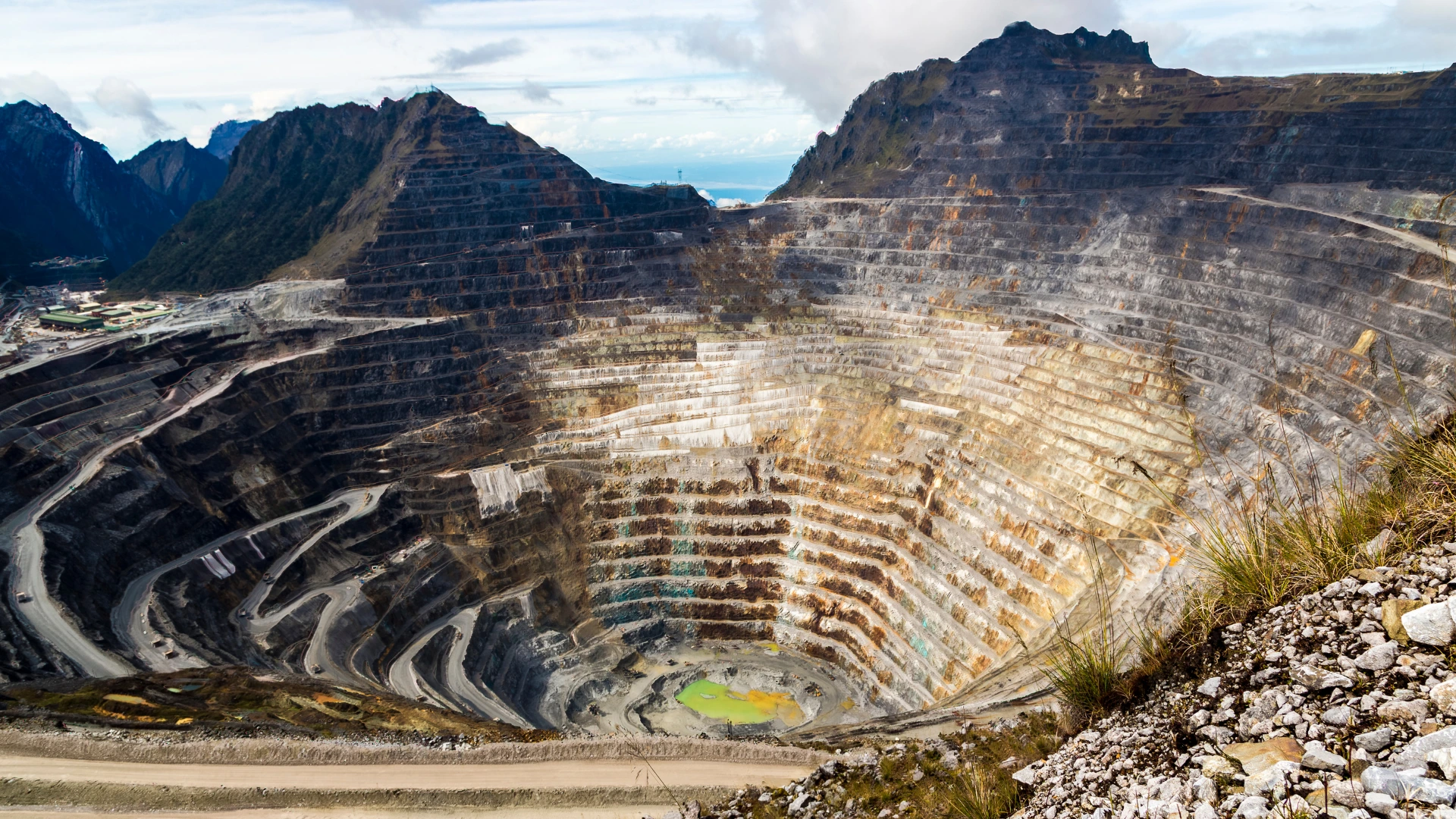
Saudi Arabia’s mining sector faces significant challenges, particularly in geological exploration. The Kingdom’s vast deserts, while rich in mineral potential, present logistical hurdles, making traditional exploration methods costly and time-consuming. Satellite imagery addresses this by providing high-resolution data to identify mineral-rich zones remotely. Using technologies like multispectral and hyperspectral imaging, mining companies can pinpoint resource-rich areas, reduce exploration costs, and accelerate discovery timelines.
Environmental concerns remain a pressing issue, as mining activities contribute to land degradation, pollution, and biodiversity loss. Satellite imagery plays a critical role in monitoring land-use changes, detecting pollution sources, and supporting reclamation efforts. By tracking vegetation loss and assessing ecosystem recovery, mining companies can minimize environmental impacts, implement sustainable practices, and align operations with global sustainability standards.
Regulatory compliance has become increasingly important as environmental regulations evolve. Traditional reporting methods are labor-intensive and inconsistent, creating challenges for mining operators. Satellite imagery offers real-time, accurate data that simplifies compliance reporting and ensures transparency. Companies can use this data to demonstrate adherence to environmental regulations, monitor reclamation progress, and mitigate risks effectively, reducing penalties and fostering trust with regulators.
Lastly, improving operational efficiency is crucial for balancing resource extraction, cost reduction, and environmental responsibility. Satellite data enhances decision-making by providing insights into site conditions, infrastructure monitoring, and risk detection. When integrated with advanced technologies like AI and drones, satellite imagery empowers mining companies to optimize operations, improve resource management, and achieve long-term sustainability. As Saudi Arabia pushes forward with Vision 2030, adopting satellite technologies will be key to unlocking the sector’s full potential.
Applications of Satellite Imagery in Mining

Satellite imagery has revolutionized mineral exploration by enabling the detection of mineral deposits from space. Multispectral and hyperspectral imaging allow geologists to analyze surface mineralogy and alteration zones, identifying promising areas for exploration.
For example, ASTER (Advanced Spaceborne Thermal Emission and Reflection Radiometer) data has been successfully applied in Saudi Arabia’s Nuqrah region to map hydrothermal alteration zones, indicating the presence of valuable minerals. This approach reduces exploration costs and speeds up the discovery process.
Environmental sustainability is a growing priority in mining. Satellite imagery helps monitor vegetation loss, land-use changes, and sources of pollution such as acid mine drainage. By tracking the environmental footprint of mining operations, companies can adopt measures to restore ecosystems.
Satellites also support reclamation projects by monitoring revegetation efforts and assessing their success over time. These insights ensure compliance with environmental regulations and promote responsible mining practices.
Satellite data assists in the planning and monitoring of essential mining infrastructure, including access roads, processing plants, and waste management facilities. By providing accurate topographic and spatial data, satellite imagery simplifies decision-making for infrastructure projects. This improves operational efficiency and minimizes environmental disruptions.
Accurate and transparent reporting is critical for regulatory compliance. Satellite imagery provides precise data that can be shared with authorities to demonstrate adherence to environmental standards. Mining companies can use this data to prepare reports, ensuring transparency and building trust with regulators and local communities.
Enhancing Mining Operations with Advanced Technologies

The integration of advanced technologies amplifies the value of satellite imagery in modern mining, enabling smarter exploration, efficient operations, and better environmental management. Artificial intelligence (AI) revolutionizes the analysis of satellite data by quickly processing vast datasets. AI algorithms detect anomalies and mineral patterns using multispectral and hyperspectral imaging, allowing mining companies to focus on high-potential areas while reducing exploration costs. This predictive modeling, paired with environmental monitoring capabilities, helps identify risks such as soil erosion and pollution, enabling proactive restoration measures.
While satellite imagery provides large-scale overviews of mining sites, drone technology offers high-resolution, localized insights that complement these observations. Satellites map extensive regions and detect broad issues like surface instability, while drones focus on specific areas to capture detailed visuals. Together, these tools enable safer operations by pinpointing hazards, such as structural weaknesses in tailing dams or inefficient infrastructure layouts, ensuring timely corrective actions to enhance site safety and efficiency.
The true potential of these technologies emerges when they are combined. Satellites monitor macro-level changes like vegetation loss, land deformation, and pollution, while drones validate findings with ground-level data. For example, when reclaiming mined sites, satellites assess the overall land condition, and drones track progress in reforestation or remediation efforts. This synergy allows mining companies to meet sustainability targets, demonstrate environmental compliance, and manage resources effectively.
In conclusion, integrating satellite imagery with AI, drone technology, and automation delivers real-time, data-driven insights that improve decision-making, productivity, and profitability. Autonomous drones equipped with AI can conduct routine inspections, while satellite data provides continuous monitoring of mining operations. Together, these innovations transform Saudi Arabia’s mining sector, ensuring it becomes a globally competitive and sustainable industry under the ambitions of Vision 2030.
Government Initiatives and International Partnerships
Saudi Arabia’s Vision 2030 reflects the Kingdom’s ambitious commitment to transforming its mining sector into a cornerstone of economic diversification. By leveraging satellite technology and AI-driven exploration tools, the government aims to unlock the full potential of its vast mineral resources while ensuring sustainable practices. This investment not only aligns with the Kingdom’s long-term economic goals but also sets a global benchmark for modern, responsible mining operations.
To drive innovation, Saudi Arabia has embraced advanced technologies such as AI-powered satellite imagery analysis. These tools enable mining companies to identify mineral-rich zones more efficiently, reducing both time and costs associated with traditional exploration. AI algorithms process extensive geological datasets, detect patterns, and pinpoint resource locations with precision. This technological advancement significantly accelerates exploration efforts, allowing companies to access remote and challenging terrains that were previously overlooked.
In addition to technological advancements, strategic international partnerships have strengthened Saudi Arabia’s position as a leader in modern mining. The recent collaboration between Platinum Group Metals and Saudi firm Ajlan & Bros for smelter development highlights the Kingdom’s proactive approach to fostering global alliances. Such partnerships not only facilitate knowledge exchange but also attract foreign investment, boosting the Kingdom’s mining sector and contributing to its broader economic vision.
The launch of AI-powered satellite imagery analysis firms further underscores Saudi Arabia’s commitment to innovation. By supporting mining exploration with data-driven solutions, the Kingdom enhances transparency, operational efficiency, and environmental responsibility. As a result, Saudi Arabia positions itself as a leader in sustainable mining, showcasing how technological advancements can align economic growth with environmental stewardship. Through Vision 2030, the Kingdom paves the way for a mining industry that balances profitability, innovation, and sustainability.
Read more about Saudi Arabia’s Vision 2030 and Mining
Benefits for Stakeholders
The adoption of satellite imagery in modern mining delivers significant benefits by enhancing exploration accuracy, reducing operational costs, and promoting sustainability. Advanced remote sensing enables mining companies to identify mineral deposits efficiently across vast, remote areas, saving time and resources compared to traditional methods. Additionally, satellite imagery allows real-time monitoring of mining activities, helping operators assess environmental impacts like deforestation or pollution. This data-driven approach optimizes resource extraction while ensuring environmental stewardship and aligning operations with sustainability standards.
Governments, regulators, and local communities also benefit from satellite technology. For regulators, reliable satellite data supports resource management, environmental compliance, and effective policy implementation, critical to Saudi Arabia’s Vision 2030 goals. For local communities, satellite-enabled monitoring minimizes ecological damage and fosters trust by promoting transparency and accountability in mining operations. Ultimately, satellite imagery bridges productivity and sustainability, driving responsible mining practices that deliver economic growth while protecting the environment for future generations.
The Future of Mining in Saudi Arabia
Saudi Arabia’s mining sector stands at the cusp of transformation, driven by Vision 2030 and powered by modern technologies like satellite imagery. By addressing challenges in exploration, operations, and sustainability, satellite technology plays a pivotal role in unlocking the Kingdom’s mineral wealth.
As mining companies, governments, and communities work together, the integration of satellite imagery with advanced tools like AI and drones ensures that mining operations are efficient, sustainable, and future-ready. To achieve long-term success, stakeholders must embrace these innovations and lead the way in modern mining practices.

