


As Saudi Arabia approaches the 2027 AFC Asian Cup, the expansion of King Fahd Sports City Stadium stands as the primary infrastructure priority.
Chosen to host the tournament’s opening and closing ceremonies, the venue requires a complete engineering overhaul to meet international standards.
This massive civil construction project involves complex structural modifications.
The expansion will increase the venue’s total capacity to over 70,000 seats. To change the multi-purpose arena into a dedicated football stadium, engineers are removing the existing running track and lowering the physical pitch by 8 meters.
The updated stadium envelope will be covered by a modern canopy roof built in the shape of 24 distinct tents, making it the joint-largest stadium in the GCC region.
Fast-tracking these interconnected structural, mechanical, electrical, and plumbing (MEP) components introduces a severe logistical challenge.
With a fixed tournament deadline, the engineering consortium has zero tolerance for installation errors or delayed schedules.
The Financial Toll of Construction Rework and Bad Data
Traditional, manual site-tracking methods cannot keep pace with the hyper-accelerated timelines of modern sports infrastructure. When managers rely on manual tape measurements, paper blueprints, and slow visual checks, critical site data becomes fragmented. This operational lag creates significant blind spots between the design office and the active construction field. Without rapid, automated data verification tools, high-profile projects frequently fall into structural bottlenecks, explaining why a staggering 77% of all megaprojects experience severe delivery delays that push completion timelines at least 40% late.
The Root Causes of the Megaproject Delay Trap
The primary driver behind these chronic project delays is not severe weather or regulatory gridlock; it is the continuous circulation of obsolete site coordinates.
In large-scale arena expansions, construction teams from different subcontractors work concurrently on tightly packed schedules.
For instance, while one crew executes heavy earthmoving to lower the physical pitch by 8 meters, another team pours the concrete foundation columns, while a separate off-site factory fabricates the structural steel canopy parts.
If the primary geodetic framework contains a minor error, or if a field engineer changes a measurement on-site without instantly updating the central model, the entire spatial ledger breaks down.
Ground crews end up building off incorrect assumptions. Because traditional land surveyors can only measure a limited number of physical points per day, structural misalignments often go completely unnoticed for weeks.
The project slowly falls into a high-risk blind spot where multi-million dollar components are actively installed in the wrong positions.
Quantifying the Multi-Billion Dollar Rework Deficit
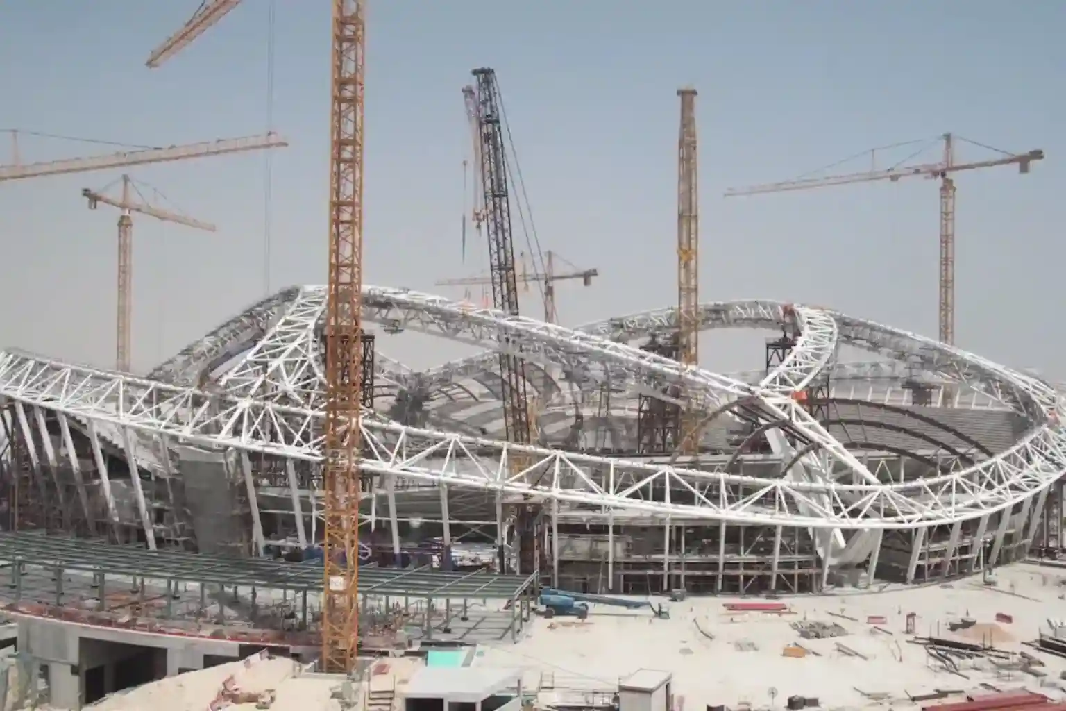
When project managers make critical structural decisions based on incorrect, unverified, or outdated information, the financial consequences compound immediately.
Global infrastructure analyses demonstrate that this systematic reliance on “bad data” is directly responsible for 14% of all construction rework executed across major projects.
When scaled up to an international level, the financial waste is massive:
- Avoidable field reworks caused entirely by poor data management cost the global construction sector an incredible SAR 333 billion in a single year.
- For a tier-1 infrastructure contractor generating SAR 3.7 billion in annual revenue, data inefficiencies result in a hidden drain of up to SAR 619 million per year in total operational losses.
- Out of that total, poor data quality causes SAR 26 million in immediate, unrecoverable cash losses spent tearing down freshly built physical structures.
These expenditures represent direct capital waste that eats into contractor profit margins and strains the financial relationship between the construction consortium and project owners.
On a fast-tracked stadium project with fixed tournament deadlines, these multi-million dollar capital drains cannot be absorbed without jeopardizing the entire engineering timeline.
The Interconnected Domino Effect on Site Productivity
The damage caused by hidden spatial errors extends far beyond immediate financial losses; it triggers an operational domino effect that disrupts the entire project ecosystem.
In modern stadium architecture, structural components rely on highly demanding tolerances.
Tolerances define the strict, millimeter-level margins of error permitted during physical assembly.
For example, the structural columns surrounding a stadium pitch must line up perfectly to support massive pre-fabricated roof sections, like a 24-tent canopy structure.
If a concrete foundation column cures with a minor five-millimeter tilt at its base, that variance compounds exponentially as the structure rises vertically.
By the time the column reaches its full height, the top bracket may be shifted out of place by several inches.
When off-site factory parts designed under perfect CAD specifications arrive on-site, they will not fit the out-of-alignment physical foundation pins.
Discovering this structural clash late forces an immediate halt to all related field tasks, causing a crushing 300% drop in localized worker productivity.
Specialized steelworkers, heavy crane operators, and mechanical installers are forced to sit completely idle while structural engineers run manual calculations, redraw layout designs, and order expensive replacement materials.
This operational freeze quickly delays subsequent trades, delaying the installation of stadium seating, stalling electrical utilities routing, and compromising sub-surface waterproofing barriers.
By eliminating these physical design clashes through early digital twin tracking, engineering groups protect their daily labor workflows and ensure the stadium moves smoothly toward its completion deadline.
The DJI Matrice 400 & Zenmuse L3 Deployment
To eliminate construction visibility gaps across a massive, multi-tiered infrastructure development, the site engineering team replaces manual line-of-sight inspections with an automated drone scanning workflow.
This high-frequency scanning operation relies on a closely matched combination of an enterprise-grade flight platform and a high-fidelity airborne laser sensor.
By deploying this specialized technology, the construction consortium can capture every physical element of the building area from an aerial viewpoint, converting the changing landscape into actionable, high-density digital assets.
Industrial Airframe Performance and Operational Efficiency
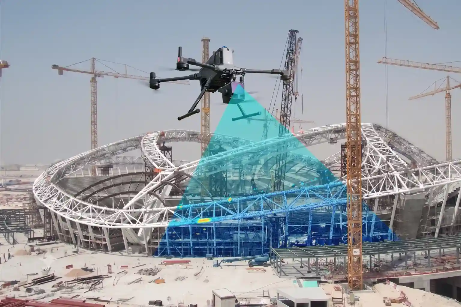
The structural baseline for this continuous reality capture process is anchored by the DJI Matrice 400 enterprise drone platform.
A stadium project of this magnitude introduces an incredibly complex airspace environment, featuring active tower cranes, scaffolding, suspended heavy machinery, and continuous ground traffic.
Standard commercial drones lack the airframe stability, wind resistance, and payload capabilities required to operate safely in these industrial conditions without disrupting on-site worker schedules.
The selected aircraft frame is engineered specifically to handle these demanding, high-risk industrial environments.
It supports a total payload capacity of 6 kg, allowing it to carry heavy, multi-sensor scanning instruments easily.
The airframe features a maximum flight endurance of 59 minutes, which minimizes the need for frequent battery swaps and maximizes uninterrupted data collection over expansive project layouts.
Additionally, the drone operates at a maximum horizontal cruise velocity of 25 m/s.
This high-speed performance permits the automated flight software to execute dense, overlapping corridor patterns rapidly.
Because the platform can navigate the entire stadium area safely from an elevated altitude, the team can complete routine weekly mapping runs without requiring ground safety clearances, halting excavation machinery, or endangering on-site personnel.
Advanced Laser Mechanics and Spatial Coordinate Stamping
For high-precision data acquisition, the platform carries the DJI Zenmuse L3 airborne LiDAR system.
This sensor payload represents a significant technical evolution in geomatics engineering by integrating a 1535nm Class 1 eye-safe laser system alongside dual 100MP RGB mapping cameras into a single, synchronized unit.
Older sensor configurations often struggle with data noise caused by heavy construction dust, flying debris, and reflection variances from wet concrete or exposed steel.
The advanced internal components of the sensor overcome these physical limits by using multi-return laser paths.
When the drone fires its laser array downward, the light pulses pass through localized dust clouds and structural gaps, recording multiple spatial returns per individual pulse.
The integrated high-resolution cameras simultaneously capture true-color visual textures, mapping them directly onto the active laser coordinates.
To ensure the collected data is mathematically useful for strict architectural audits, the system pairs these sensor readings with a high-precision position and orientation system (POS).
The drone maintains a continuous, real-time kinematic (RTK) data link with local ground base stations, providing a fixed horizontal positioning accuracy of 1.0 cm + 1 ppm and a vertical precision of 1.5 cm + 1 ppm.
This real-time synchronization completely overrides standard GPS drift, stamping every single point within the digital dataset with exact, real-world geographic coordinates.
Survey-Grade Volumetric Constraints and Mapping Yields
The true value of this hardware deployment lies in its ability to combine tight survey-grade precision with high spatial mapping efficiency.
When operating at a standard flight altitude of 120 meters above the stadium floor, the sensor system secures an absolute Vertical Accuracy of 3 cm (RMSE) and a Horizontal Accuracy of 4 cm (RMSE). This extreme accuracy ensures that the physical dimensions captured by the drone reflect the true status of the terrain without geographic distortion.
This high structural precision does not require a sacrifice in field mapping speed. By adjusting the automated flight parameters to a higher, optimized altitude of 300 meters, a single flight scan can easily cover an expansive area of up to 10 square kilometers.
When scaled across full daily shift schedules, the drone workflow achieves a maximum operational coverage rate of up to 100 square kilometers per day.
This high data yield enables the geomatics team to map the entire stadium bowl, the surrounding training grounds, and the heavy transit connection pathways within a fraction of the time required by traditional methods.
The resulting high-density point clouds provide engineers with an immediate, complete digital overview of the construction project, laying the groundwork for automated structural deviation tracking.
The Scan-to-BIM Workflow: Executing As-Built vs. Design Deviation Audits
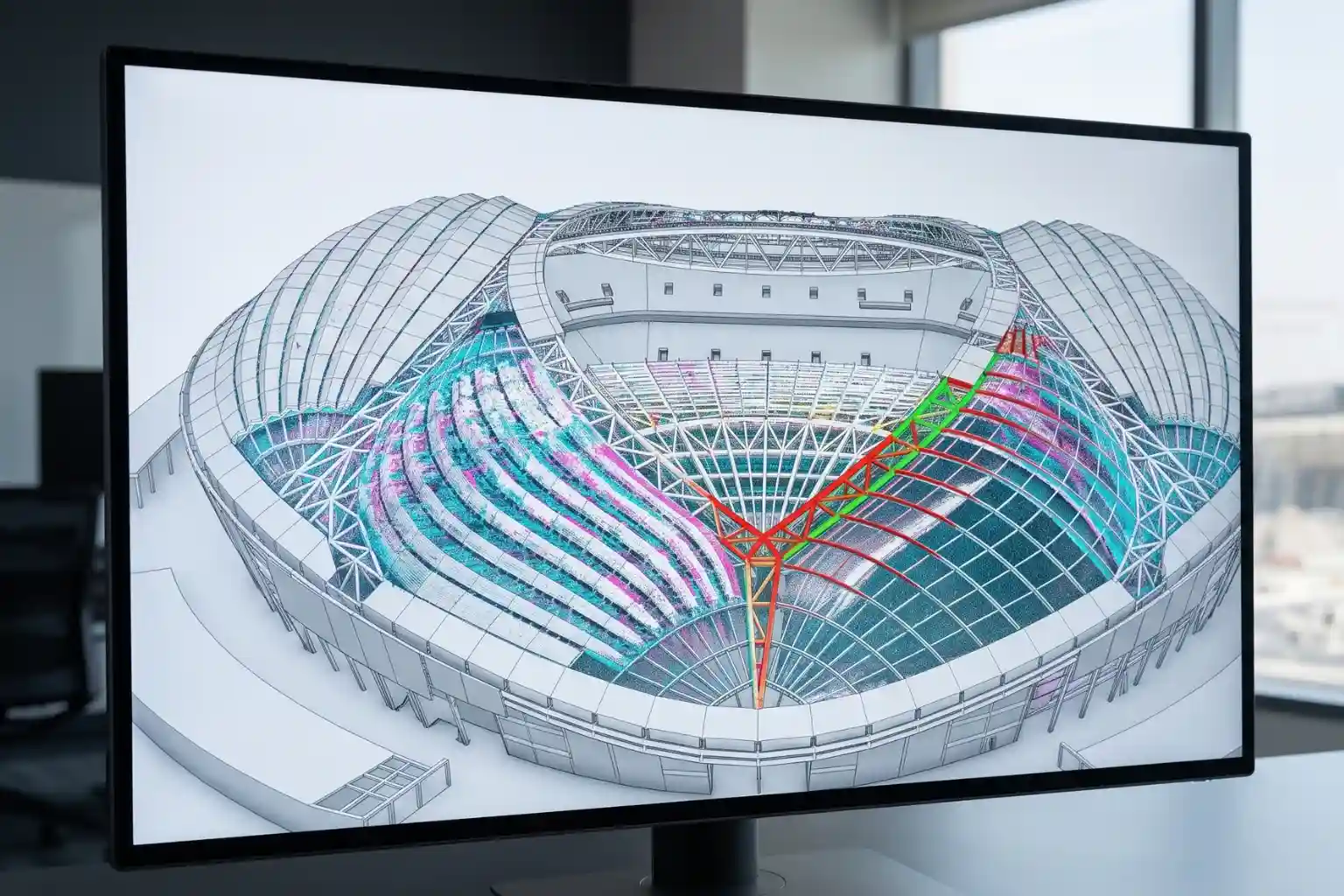
The drone follows a pre-programmed, automated flight path over the stadium bowl and the complex canopy structures.
Using an integrated 3-axis gimbal, the sensor captures both vertical concrete columns and horizontal roof elements.
The Zenmuse L3 resolves a major limitation of older sensors by generating an ultra-thin point cloud with a structural thickness of just 1.2 cm at a 120-meter altitude.
This low data noise allows the processing software to construct a clean, hyper-accurate digital twin of the physical stadium.
Drone LiDAR Flight ➔ 1.2 cm Thin Point Cloud ➔ IFC File Export ➔ BIM Blueprint Overlay ➔ Automated Deviation Flag
Once the weekly flight grids are completed, the point cloud data is exported as standard IFC files.
Engineers overlay this physical as built digital twin directly on top of the project’s original Building Information Modeling (bim) design blueprints.
Automated clash-detection software compares the physical reality against the design models. If a poured concrete foundation pier or a steel roof bracket deviates from the architectural blueprints by even a minor margin, the system flags the variance instantly.
This allows the construction consortium to correct placement errors on-site while the concrete is still curing, completely avoiding the need for expensive modifications after pre-fabricated components arrive from off-site factories.
Protecting The 2027 Asian Cup Venue
Transitioning from slow, manual field inspections to automated drone-based spatial audits provides the absolute precision required for modern stadium projects.
By implementing a digital twin workflow, the King Fahd Sports City Stadium expansion group completely bypasses the 14% bad-data rework.
The continuous integration of the DJI Matrice 400 and Zenmuse L3 LiDAR system provides project owners with an indisputable visual ledger of physical progress.
Contact our expert to protect your construction budgets, ensure that complex pre-fabricated tent roofs align perfectly with poured ground supports, and secures your deadline with clear geomatics engineering verification.

 English