Satellite imagery is helping construction revolutionize how projects are planned, monitored, and executed. From providing accurate site assessments to tracking real-time progress, this technology is reshaping the construction industry. With its ability to offer high-resolution visuals and comprehensive data, satellite imagery addresses many challenges construction teams face, such as delays, cost overruns, and environmental compliance. By integrating satellite data, stakeholders can enhance decision-making, improve collaboration, and achieve sustainable outcomes like never before.
Overview of the Construction Industry’s Challenges
Common Bottlenecks and Complex Relationships
The construction sector is notorious for delays, cost overruns, and inefficiencies. These bottlenecks often arise from misaligned priorities, communication gaps, and a lack of reliable data among stakeholders. With diverse teams such as contractors, consultants, and project owners involved, conflicting interests can exacerbate delays and disputes.
At the heart of these challenges lies the need for accurate and timely data. Proper site analysis and monitoring are critical, yet traditional methods like ground surveys or manual inspections often fall short. This is where satellite imagery transforms the game, providing an efficient and reliable solution for modern construction projects.
Challenges in the Construction Industry
Assessing large or inaccessible sites is often a time-intensive process; moreover, without real-time data, project teams struggle to identify potential risks and prepare accurate plans. Consequently, limited visibility into project status frequently results in inefficiencies, while compliance and quality assurance become challenging without the proper tools to reliably track progress.
At the same time, sustainability goals are increasingly becoming a priority for modern construction projects. Therefore, identifying potential risks, such as erosion or flooding, and adhering to regulatory standards are critical for achieving environmental compliance. However, unforeseen site conditions and inefficiencies in data collection can significantly inflate project budgets, emphasizing the need for accurate pre-construction data to maintain cost control.
In addition, reliable data sharing among stakeholders remains a persistent challenge. Without consistent communication and a unified source of truth, delays and disputes are more likely to arise, further complicating project workflows. These challenges underscore the transformative role of satellite imagery in addressing construction challenges, offering innovative solutions to streamline processes and ensure efficiency.
The Role of Satellite Imagery in Addressing Construction Challenges

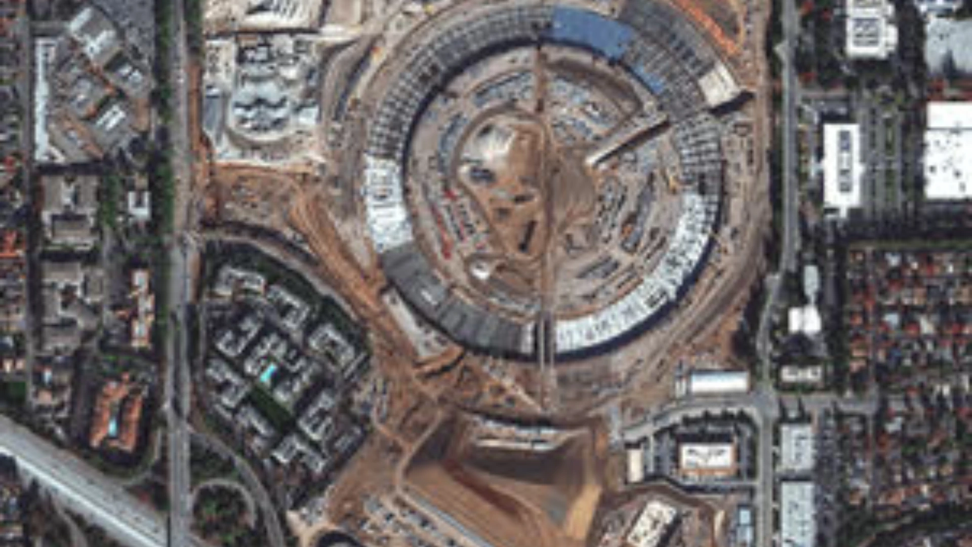
Satellite imagery provides high-resolution data on topography, terrain, and land use, enabling efficient assessments even in remote areas. This capability not only saves time but also eliminates the need for repeated on-site surveys, significantly streamlining project initiation. Additionally, when integrated with GIS, satellite imagery enables advanced spatial analysis and precise 3D modeling. Using elevation data, construction teams can optimize designs and improve planning efficiency.
Real-Time Monitoring and Progress Tracking

Regular updates from satellite imagery give project teams a comprehensive macro view of construction progress. By detecting deviations from initial plans, such as unauthorized structures or delays, teams can address issues promptly to stay on schedule. Multi-spectral satellite data further enhances project success by identifying environmental risks like erosion or flood zones. These insights ensure regulatory compliance and support sustainable building practices.
Satellite imagery also serves as a unified source of truth, offering visual data to all stakeholders. This fosters better communication, improves alignment, and reduces the likelihood of disputes. By cutting reliance on costly and time-consuming ground surveys, satellite imagery becomes an ideal solution for large-scale or multi-site projects, making it indispensable for expanding construction portfolios.
Read how satellite data supports regulatory compliance: click here
Enhancing Construction Insight with Remote Sensing Techniques
While drones provide localized, high-resolution visuals, satellite imagery offers broad, high-level views of construction sites. Together, these technologies work seamlessly to deliver comprehensive insights that enhance project understanding.
Furthermore, when overlaid on satellite basemaps, drone imagery offers unmatched clarity and context. This powerful combination enables both macro and micro-level analysis, which is essential for efficient project management and strategic decision-making.
By leveraging satellite imagery for large-scale visibility and drone data for detailed inspections, construction companies can monitor projects end-to-end. This integrated approach proves especially useful for tracking progress, managing safety risks, and ensuring regulatory compliance throughout the project lifecycle.
The construction industry has long grappled with challenges such as effective project management, meeting compliance standards, and adhering to tight deadlines. However, satellite imagery is helping construction companies overcome these hurdles with unprecedented precision and efficiency. By incorporating satellite-based data into project workflows, stakeholders gain clearer site visibility, empowering them to make smarter decisions, cut costs, and achieve sustainable outcomes.
Overview of the Construction Industry’s Challenges
The construction sector is notorious for delays, cost overruns, and inefficiencies. These bottlenecks often arise from misaligned priorities, communication gaps, and a lack of reliable data among stakeholders. With diverse teams such as contractors, consultants, and project owners involved, conflicting interests can exacerbate delays and disputes.
At the heart of these challenges lies the need for accurate and timely data. Proper site analysis and monitoring are critical, yet traditional methods like ground surveys or manual inspections often fall short. This is where satellite imagery transforms the game, providing an efficient and reliable solution for modern construction projects.
Challenges in the Construction Industry
Assessing large or inaccessible sites can be a time-consuming process. Without real-time data, project teams struggle to identify potential risks and prepare accurate plans, which often hampers decision-making.
Moreover, limited visibility into project status frequently results in inefficiencies. Compliance and quality assurance also remain challenging without the right tools to reliably track progress and ensure alignment with goals.
As sustainability becomes a priority in modern construction, identifying risks such as erosion or flooding and adhering to regulatory standards is now more crucial than ever. Environmental compliance hinges on the ability to assess these factors accurately.
Unforeseen site conditions and inefficient data collection can further complicate matters by inflating project budgets. This highlights the need for accurate pre-construction data to keep costs under control and minimize financial risks. Reliable data sharing among stakeholders remains a challenge. Without consistent communication and a unified source of truth, delays and disputes are inevitable, undermining collaboration and project timelines.
The Role of Satellite Imagery in Addressing Construction Challenges

Satellite imagery is helping construction overcome traditional hurdles by providing high-resolution data on topography, terrain, and land use. This capability enables efficient assessments, even in remote areas, saving time and eliminating the need for repeated on-site surveys.
By integrating satellite imagery with Geographic Information Systems (GIS), construction teams unlock advanced spatial analysis and 3D modeling capabilities. These tools enhance elevation analysis, optimize designs, and streamline planning processes. For instance, multi-phase residential or industrial projects benefit from detailed insights without requiring large ground-based teams.
Satellite imagery also delivers a macro perspective of construction progress, allowing teams to detect and address deviations like unauthorized structures or delays. With regular updates, stakeholders can make informed decisions in real time, especially when unforeseen site changes arise. Additionally, multi-spectral imaging identifies environmental risks such as erosion or flooding, helping teams meet sustainability goals while avoiding fines and delays.
One of the most significant advantages of satellite imagery is its cost-efficiency. Traditional ground surveys are resource-intensive and expensive, particularly for large or inaccessible sites. Satellites reduce these costs by remotely collecting critical data. For example, while assessing a site spanning hundreds of kilometers may cost tens of thousands of dollars with traditional methods, satellite imagery delivers similar insights at a fraction of the cost.
Satellite data is not a standalone solution; its full potential emerges when combined with other technologies like drones. Drone imagery, with its high resolution, complements satellite coverage by offering detailed local insights. When integrated into GIS platforms, this combination enables construction teams to extract actionable information quickly, improving project planning and execution.
In summary, satellite imagery is helping construction teams redefine efficiency and cost management. By providing scalable solutions and supporting sustainable practices, satellites are revolutionizing how construction projects are planned, monitored, and completed.
Enhancing Construction Insight with Remote Sensing Techniques

While drones offer localized, high-resolution visuals, satellite imagery provides a wide, overarching view of construction sites. Together, they deliver comprehensive insights that drive smarter project decisions. Overlaying drone imagery on satellite base maps creates unmatched clarity and context, enabling both macro and micro-level analysis. This synergy is essential for efficient project management, ensuring no detail is overlooked while maintaining a broad perspective.
By leveraging satellite imagery for large-scale visibility alongside drone data for detailed inspections, construction companies can achieve end-to-end project monitoring. This approach enhances progress tracking, improves safety management, and ensures regulatory compliance, all while optimizing efficiency.
How Construction Stakeholders Benefit
For Construction Companies
- Better site planning and resource allocation
- Improved risk mitigation and operational efficiency
For Design Consultants
- Access to detailed and multi-layered site data
- Precision in design and structural planning
For Contractors
- Streamlined project monitoring
- Visual tools for safety planning and compliance
For Project Owners and Investors
- Reliable updates for financial and risk assessments
- Enhanced transparency with actionable insights
Future Trends in Satellite and Drone Integration for Construction
The integration of satellite and drone technologies is transforming the construction industry, unlocking groundbreaking capabilities and enabling smarter project management. As advancements in artificial intelligence (AI), machine learning, and IoT continue to evolve, they are revolutionizing how data is analyzed and applied to construction.
AI-powered tools now allow construction teams to process satellite and drone data more efficiently, offering predictive modeling and proactive risk assessment. For instance, machine learning algorithms analyze high-resolution imagery to detect anomalies, optimize resource allocation, and streamline workflows, minimizing delays and inefficiencies. This approach ensures a more seamless and informed construction process.
Digital twins, created using satellite and drone data, are enabling project teams to simulate scenarios and resolve issues before implementation. Combined with IoT sensors for real-time tracking of equipment and materials, these technologies bridge the gap between planning and execution, ensuring maximum efficiency on-site.
Satellite technology is also becoming more accessible, with nanosatellites and commercial satellite networks reducing costs and expanding data availability. Even smaller firms now have access to affordable, detailed imagery for site assessments and project monitoring. Subscription-based services eliminate the need for significant upfront investments, making these tools widely available.
Sustainability is another critical benefit, as multispectral imagery helps assess vegetation and identify risks such as erosion. These insights promote eco-friendly practices and align with international environmental standards. By optimizing resource use and minimizing waste, satellite and drone technologies contribute to lower carbon footprints in construction projects.
This integration of technologies is not just about efficiency; it is reshaping construction to be more sustainable and resilient. By combining innovation with precision, stakeholders are better equipped to meet global challenges and deliver projects that align with future-ready standards.
What We Can Do
Terra Drone Arabia specializes in high-resolution satellite imagery and tailored GIS solutions for construction. From site assessments to progress monitoring, we deliver end-to-end support for project success. By integrating satellite and drone data, we offer comprehensive insights that drive smarter decisions. Our user-friendly reporting tools enable teams to visualize and act on critical data with ease.
Why Satellite Imagery is Transforming Construction?
Satellite imagery is helping construction stakeholders overcome traditional challenges by offering precise data for planning, monitoring, and collaboration. Ready to optimize your construction projects? Contact Terra Drone Arabia today to discuss how our satellite imagery solutions can help your business thrive.

