


As Saudi Arabia accelerates its shift toward alternative energy under Saudi Vision 2030, the development of modern infrastructure requires automated maintenance systems.
The King Salman Energy Park (SPARK) stands as a major part of this transition, operating as a sustainable industrial hub built to advance the digitalization and energy transition goals of the Kingdom.
This mega-project introduces unprecedented scale to the region. SPARK represents a massive, master-planned industrial city covering a complete infrastructure layout area of 50 square kilometers.
The installation of smart grids and clean power networks at the facility directly aligns with a national solar capacity surge, where the Kingdom’s total operated renewable energy project capacity has recently reached 6,551 MW.
This renewable ecosystem is heavily powered by nine large-scale solar energy projects delivering a combined capacity of 6,151 MW.
To achieve these metrics, the government has directed massive capital into the sector, scaling the total national renewable investment volume to SAR 19.8 billion, with SAR 18.2 billion dedicated directly to high-capacity solar infrastructure.
Maintaining peak electrical performance across these vast solar panel arrays introduces a significant operations and maintenance (O&M) challenge.
Without rapid, automated diagnostics, localized power drops can disrupt smart grids and compromise energy delivery.
Identifying Solar Defects and Ground Inspection Latency
Traditional, manual ground inspections cannot keep up with the massive spatial footprints of modern utility-scale solar installations.
When O&M teams rely entirely on handheld thermal cameras, physical walk-throughs, and delayed electrical testing, critical panel defects remain hidden for months.
This operational delay between defect development and active physical maintenance creates significant performance gaps that quietly drain capital from asset owners.
The Lack of Traditional SCADA and Manual Latency
Supervisory Control and Data Acquisition (SCADA) systems serve as the primary monitoring mechanism for large-scale energy facilities, yet they possess inherent structural blind spots.
While a SCADA dashboard tracks macro-level parameters such as inverter outputs, weather station irradiance, and overall performance ratios, it cannot see down to the individual photovoltaic cell level.
Consequently, between 10% and 30% of total energy losses in active solar fields go completely unnoticed by traditional ground-based SCADA systems.
Small faults like localized bypass diode failures, partial soiling, or early-stage Potential Induced Degradation (PID) do not alter the system-wide electrical profile enough to trigger an automatic alert; they hide beneath the general operational noise.
To catch these micro-defects, traditional O&M strategies mandate physical walk-throughs by field technicians. However, manual inspections are severely constrained by human physical limits:
- Coverage Speed Constraints: A trained technician walking panel rows with a handheld thermal camera can cover roughly 1 to 2 MW per day.
- Timeline Bottlenecks: On a standard 50 MW solar farm layout, a complete manual walkthrough requires anywhere from 25 to 50 working days of continuous on-foot field labor.
- Inspection Gaps: Because human reviews are logistically slow and expensive, operators typically schedule them only once or twice a year, leaving many modules unchecked for up to six months at a time.
Furthermore, manual observations rely heavily on individual operator skill and ambient outdoor conditions, leading to poor data consistency.
Manual thermal reviews capture only 60% to 75% of actual system anomalies. Subtle, early-stage faults are routinely missed, leaving hidden degradation mechanisms to expand across the solar field completely unchecked.
The Risk of Financial Decay of Undetected Anomalies
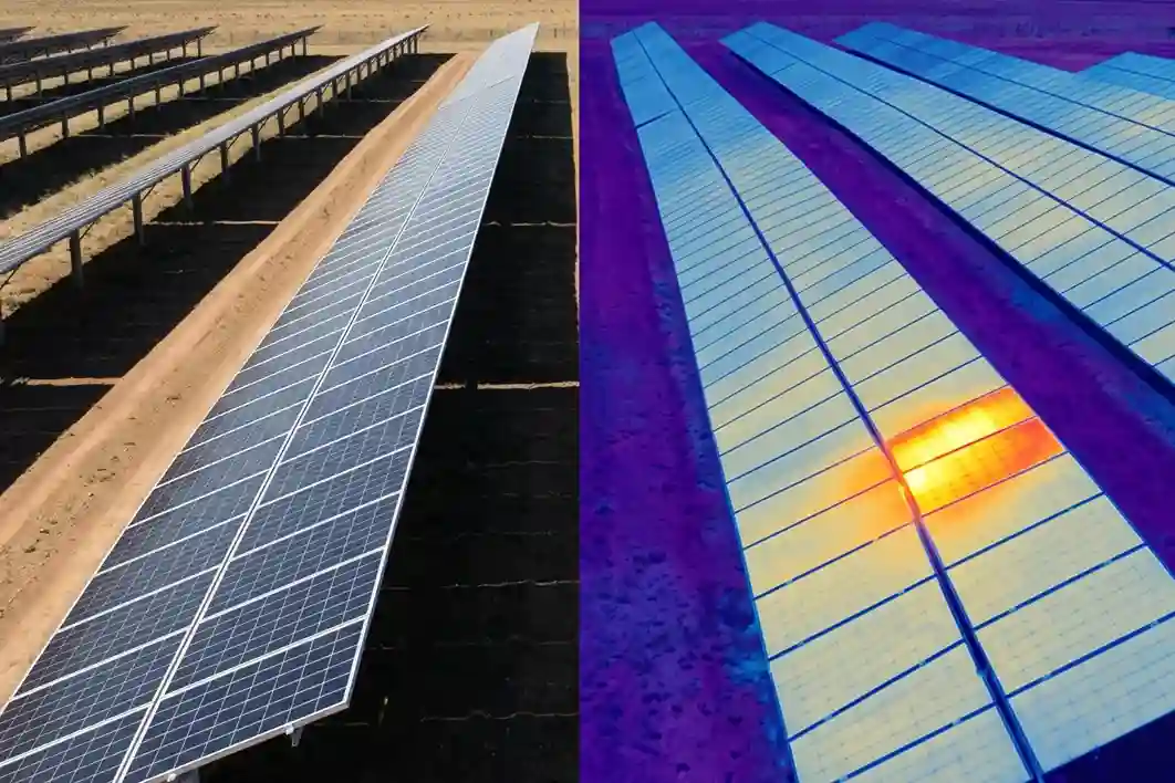
Allowing small cell anomalies to go undetected creates a direct, measurable financial deficit for asset management companies.
According to the NREL O&M Best Practices Guide, implementing automated early detection workflows reduces long-term lifetime yield losses by 15% to 30%.
When scaled over a 25-year asset lifespan, this yield protection directly influences project profitability and payback periods.
The contrast in expenditures between outdated manual inspection practices and automated aerial thermography is distinct:
- Manual Inspection Expenses: Combined labor, equipment, and manual reporting costs demand between $800 and $1,200 per MW for each site walkthrough.
- Aerial Digital Mapping Costs: Advanced drone scanning, including automated data classification, drops operational expenses down to a range of $150 to $500 per MW.
- Direct Revenue Generation: Large-scale portfolio data compiled across operating clean energy sites confirms that automated aerial thermography audits save asset managers an average of $2,100 per MW inspected in recovered electrical generation.
“A structural fault detected and repaired weeks earlier means weeks of prevented generation loss. In an industrial energy field, this timing difference alone represents thousands of dollars in reclaimed output.”
By switching to high-precision risk mapping, solar operators can reduce overall operations and maintenance (O&M) costs by 15% to 25%.
These recovered funds can then be reinvested back into site optimization, directly strengthening the financial security of the facility.
The Thermal Cascade and Severe String Failures
When localized cell anomalies are left uncorrected, they trigger an operational domino effect known as a thermal cascade.
In standard photovoltaic module architecture, solar cells are wired together in a tight electrical series.
Within a series-connected design, the electrical current flow is strictly limited by the weakest individual contributor in the loop.
If a single cell develops an internal microcrack or suffers from partial shading due to dust buildup, its electrical resistance rises rapidly.
Instead of safely passing the generated current along, the damaged cell begins acting as an electrical consumer, actively absorbing energy from the surrounding healthy modules.
This concentrated energy absorption causes the cell’s physical surface temperature to spike, creating a localized hotspot.
Cell Microcrack/Soiling ➔ Increased Electrical Resistance ➔ Energy Absorption ➔ Severe Hotspot Creation
To protect the module from structural cracking or catching fire, the panel’s internal bypass diodes activate, completely routing the electrical current around the affected cell block.
While this safety feature protects the physical frame, it permanently drops the voltage output of that specific module.
This drop triggers a severe phenomenon known as a string current mismatch, where the performance of an entire 20-to-30 panel row is dragged down to match the compromised output of its weakest unit.
Discovering these spatial mismatches late through manual methods causes a crushing drop in localized worker productivity.
Maintenance technicians are forced to manually test thousands of individual electrical junctions across kilometers of open desert terrain to isolate the failing string.
By using high-fidelity aerial digital twins to pinpoint these thermal anomalies early, engineering groups protect their daily maintenance workflows and ensure the solar farm maintains peak generation capacity.
High-Frequency Diagnostics: Deploying the DJI Mavic 3 Thermal
To maintain optimal energy yields across large-scale solar arrays without creating operational safety hazards, the site management team replaces traditional ground-based inspections with an automated aerial thermography workflow.
This high-frequency scanning operation relies on a compact, highly integrated commercial drone platform optimized for rapid asset diagnostics.
By deploying this specific airborne system, engineers can systematically audit thousands of photovoltaic modules per hour, translating physical surface temperatures into actionable data for the facility’s localized smart grid.
Airframe Portability and Field Deployment Efficiency
The physical baseline for this continuous grid audit is anchored by the DJI Mavic 3 Thermal folding enterprise drone platform.
Large-scale utility solar installations introduce a challenging landscape for heavy industrial machinery.
Traditional commercial inspection aircraft are often large, heavy, and require multi-person crews, complex assembly steps, and specialized transport vehicles.
These logistics severely limit how often surveys can be conducted. The selected quadcopter airframe solves these operational constraints through a highly portable design.
Weighing just 920 grams, the compact drone can be unfolded and deployed by a single technician within minutes, requiring no ground clear-outs or operational shutdowns.
The small airframe is paired with a high-capacity power cell optimized for sustained industrial flights.
The drone achieves a maximum flight time of up to 45 minutes under optimal conditions, minimizing battery-swapping downtime and maximizing continuous data collection across widespread panel grids.
Operating at a standard flight speed, a single automated mission can cover up to 2 square kilometers of land terrain before requiring a battery change.
When scaled across a routine daily shift, a single geomatics inspector can quickly map multi-megawatt sectors.
Because the aircraft navigates safely from an elevated altitude, it completely eliminates the slow tracking speeds and personal safety risks associated with technicians walking through remote desert environments.
Radiometric Sensor Mechanics and Thermal Sensitivity
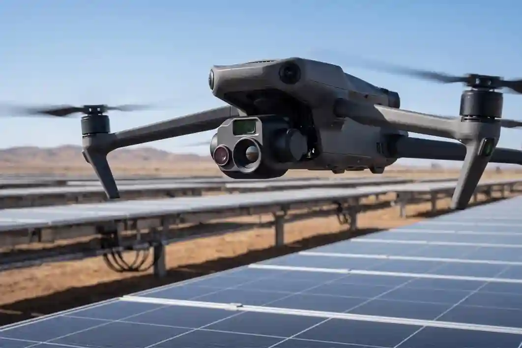
For deep defect tracking across massive panel arrays, the drone utilizes a specialized, uncooled VOx microbolometer thermal sensor mounted to a 3-axis mechanical gimbal.
While standard visual cameras only capture reflected light within the visible spectrum, this radiometric sensor reads raw long-wave infrared energy radiating directly off physical objects.
The sensor processes this thermal energy to output a dedicated radiometric resolution of 640×512 pixels at a 30Hz frame rate.
This high frame rate provides a smooth, continuous data stream, preventing motion blur or data gaps as the drone executes automated mapping corridors.
The primary engineering benefit of this payload is its high thermal sensitivity, recorded as a Noise Equivalent Temperature Difference (NETD) of less than 50mK.
This sensitivity allows the sensor to register minute surface temperature differences down to fractions of a single degree Celsius. When the drone passes over an active solar farm, the sensor captures the exact heat profile of every module.
Defective components, which draw internal resistance and absorb energy instead of passing it along, are highlighted instantly as localized hotspots.
The high radiometric resolution ensures that engineers can distinguish between benign surface reflections and serious internal failures, such as shorted bypass diodes or failing module sub-strings.
Multi-Sensor Visual Zoom and Precision Coordinate Stamping
To maximize on-site troubleshooting efficiency, the payload combines its thermal core with a dual-optical camera network.
The thermal sensor sits directly alongside a 48MP wide camera and a 12MP telephoto lens that supports up to 56× hybrid zoom.
When the automated scanning software flags a thermal anomaly, the pilot can activate a 28× continuous side-by-side digital zoom mode on the remote controller display.
This function places the live visible-light image right next to the radiometric infrared heat feed.
Maintenance teams can instantly determine if a hotspot is caused by an internal electrical short or an external factor, such as a surface layer of sand, bird drop contamination, or physical glass breakage.
To ensure the collected data can be immediately translated into targeted repairs, the drone’s telemetry system is paired with a detachable enterprise RTK module.
This positioning module maintains a continuous data link with local reference stations, providing a fixed horizontal positioning accuracy of 1 cm + 1 ppm and a vertical positioning precision of 1.5 cm + 1 ppm.
The system automatically stamps every thermal pixel with exact, real-world geographic coordinates.
This real-time georeferencing removes all positioning guesswork. When the final asset anomaly map is compiled, ground technicians can navigate straight to the exact faulty module within a large industrial park, entirely bypassing the need for slow, manual circuit testing.
Implementing the Aerial Solar Audit Workflow
The automated drone survey moves through four distinct steps to convert raw thermal data into targeted field repairs.
Autonomous Flight Path ➔ Radiometric Data Capture ➔ Digital Twin Assembly ➔ CMMS Work Order Generation
- Automated Data Acquisition: The drone follows pre-programmed autonomous flight paths over the solar fields. Using automated terrain-follow scanning, the aircraft dynamically adjusts its altitude to match the slope of the land, keeping a constant height above the solar panels to ensure uniform data resolution.
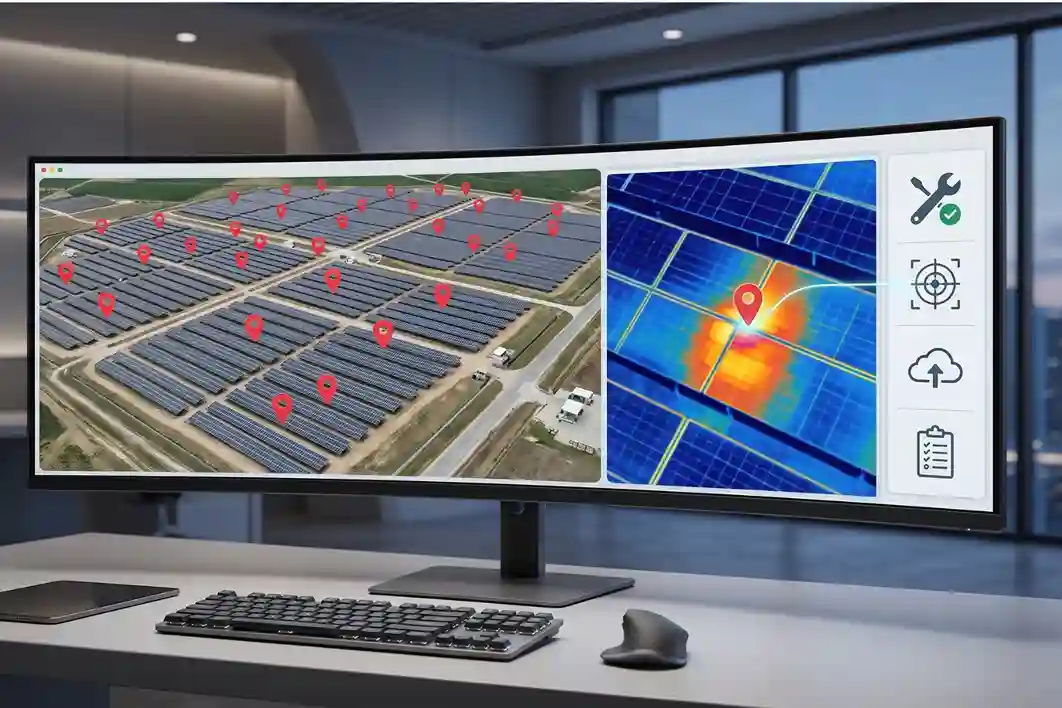
- Building the Visual Ledger: Once the flight is complete, the radiometric imagery is processed to construct a complete digital twin of the active solar farm. This twin acts as an updated spatial record of the entire facility.
- Thermal Defect Isolation: Automated diagnostic software scans the digital twin to flag temperature anomalies. The system automatically categorizes errors based on their thermal signatures, separating single-cell hotspots (caused by internal microcracks) from full-string failures (caused by faulty inverter connections).
- BIM and CMMS Integration: The identified anomalies and their exact RTK coordinates are exported directly into the facility’s Computerized Maintenance Management System (CMMS). Ground repair crews receive automated work orders with precise panel locations, allowing them to replace faulty modules immediately without manual troubleshooting.
Driving Tech-Driven O&M Transparency
Replacing slow, manual ground inspections with automated aerial thermography provides the data clarity required to operate modern renewable energy hubs.
By implementing a high-accuracy digital twin workflow driven by the DJI Mavic 3 Thermal platform, operators at the King Salman Energy Park completely eliminate the undetected energy loss trap.
Consult with our expert to protect your multi-billion solar investments, recover thousands of dollars per megawatt in lost electrical generation, and secure long-term grid reliability.

 English