The Involvement of the UAV and ROV in Offshore Industry

The role of UAV and ROV in offshore industry for complete asset inspection.

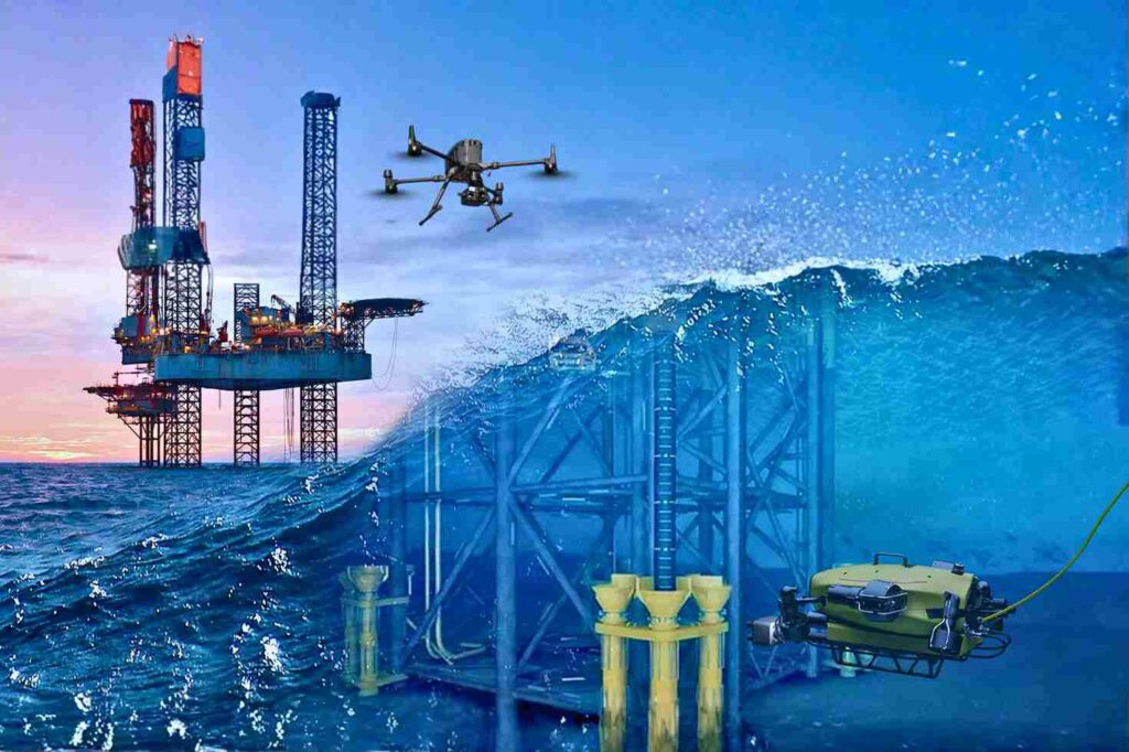
Offshore Operations in a High-Risk, Data-Driven Era The offshore energy sector operates on the edge of what is physically possible. Platforms stand isolated in the middle of the ocean, battered by saltwater, high winds, and unpredictable currents. In this hostile environment, the challenge of maintaining infrastructure is immense. Steel corrodes faster, structural fatigue sets in deeper, and the complexity of subsea networks makes monitoring a logistical nightmare. For decades, operators accepted high risk as the cost of doing business. Maintaining these assets meant sending rope-access technicians dangling from flare tips or deploying human divers into dark, crushing depths. These traditional methods are slow, incredibly expensive, and dangerously reliant on human physical endurance. Today, facing strict environmental regulations and the need for operational efficiency, these old ways are no longer sustainable. The industry requires a fundamental shift. This shift is defined by the role of UAV and ROV in offshore industry. Unmanned Aerial Vehicles (UAVs) and Remotely Operated Vehicles (ROVs) are no longer just supplementary tools; they are critical enablers. They act as the eyes and hands of the operator in environments where humans simply should not go. By adopting these robotic systems, offshore operators can finally meet modern requirements for speed, accuracy, and absolute risk reduction. How UAV and ROV Systems Transform Offshore Asset Management The transformation is comprehensive. It covers the asset from the tip of the flare stack in the sky to the pipeline buried in the seabed. I. Surface-Level Inspection with UAVs The topside of an offshore platform is a dense maze of piping, cranes, and high-voltage equipment. UAVs (drones) revolutionize how we inspect these diverse components. Visual and Thermal Precision: We use high-resolution cameras to capture millimeter-level details of rust or loose bolts on crane booms and drilling derricks. Simultaneously, thermal sensors detect insulation breaks or overheating electrical components without requiring a shutdown. Flare Stack Safety: Inspecting a live flare stack is one of the most dangerous jobs offshore. Drones can fly close to the flame, using zoom lenses and thermal imaging to check the tip’s condition while the facility remains in full production. This application alone saves millions in potential shutdown costs. Contact NDT: Advanced drones, like the Voliro T, go beyond looking. They can fly up to a vertical pipe or storage tank wall and press an ultrasonic probe against it. This allows for Non-Destructive Testing (NDT) at height, measuring wall thickness to detect internal corrosion without building a single scaffold. II. Subsea Inspection and Monitoring with ROVs Below the waterline, the environment is even more unforgiving. ROVs are the essential workhorses for subsea integrity. Structural Integrity: ROVs inspect the massive steel jackets and mooring chains that hold the platform in place. They clean off marine growth to inspect welds and check the status of sacrificial anodes, ensuring the cathodic protection system is working to stop corrosion. Pipeline and Riser Inspection: Subsea pipelines are the lifelines of the operation. ROVs travel kilometers along the seabed, using sonar and video to check for leaks, free spans (where the pipe is unsupported), or damage from anchors. Operational Support: During drilling operations, ROVs act as the “eyes” for the drill team, monitoring the blowout preventer (BOP) and subsea trees to ensure every connection is secure. III. Environmental Compliance and Emission Monitoring Regulatory pressure is increasing globally. Operators must prove they are not harming the environment. The role of UAV and ROV in offshore industry is central to this compliance. Aerial Methane Detection: Drones equipped with sensitive gas detectors fly autonomous patterns around the platform to sniff out methane leaks. They quantify Greenhouse Gas (GHG) emissions with a precision that handheld sensors cannot match, ensuring compliance with strict environmental standards like OGMP 2.0. Seabed Impact: ROVs perform environmental surveys of the seabed, taking sediment samples and mapping the area to ensure drilling activities are not damaging local marine ecosystems. IV. Operational Efficiency and HSE Improvements The most immediate impact of this technology is on Health, Safety, and Environment (HSE) metrics. Removing People from Harm: Every hour a drone spends inspecting a riser is an hour a human does not spend hanging over the water. Every hour an ROV spends checking a weld is an hour a diver does not spend under pressure. Reducing Logistics: Traditional inspections often require hiring specialized support vessels (DSVs) or accommodation barges for large crews. Robotic inspection teams are small and agile, drastically reducing the logistical footprint and cost of the campaign. Why Offshore Operators Are Accelerating UAV & ROV Adoption The move to robotic inspection is driven by hard data and financial reality. V. Improved Data Accuracy and Frequency High-Density Data: Drones do not just take photos; they capture LiDAR data. This laser scanning creates a dense 3D point cloud of the entire topside, allowing engineers to measure distances and plan modifications with centimeter accuracy. Sonar Clarity: In murky water, human divers are blind. ROVs use multibeam sonar to “see” through the silt, creating perfect acoustic images of subsea assets. Frequency: Because robotic inspections are cheaper and faster, operators can perform them more often. Instead of a major survey every five years, you can inspect critical nodes annually, catching problems before they become failures. VI. Lower Operational Cost and Downtime No Shutdowns: The ability to inspect live assets—like flares and operating risers—means production continues uninterrupted. The value of avoiding a single day of shutdown often pays for the entire inspection program. Speed: Drone inspections can reduce the time required for visual surveys by up to $50-$75 compared to rope access methods. This efficiency frees up bed space and resources on the platform for other critical maintenance tasks. VII. Enhanced Safety and Regulatory Compliance Zero Confined Space Entry: For internal inspections of tanks or vessels on FPSOs (Floating Production Storage and Offloading units), we use specialized caged drones like the Terra Xross 1. These fly inside the dark, hazardous tank while the pilot stays safely outside, completely eliminating the risk of confined space entry. Audit Trails: Robotic data is objective. It provides a

How Drone Topographic Surveys Improve Power Transmission Project Timelines

Drone conducting topographic mapping in the transmission corridor.

Drone topographic surveys are transforming how we map and deliver power transmission projects. With growing energy demands and infrastructure targets tied to Saudi Arabia’s Vision 2030, utility providers and EPC contractors face intense pressure to optimize construction schedules and reduce planning delays. Traditional ground-based survey methods, while accurate, are often slow, labor-intensive, and prone to bottlenecks in vast or remote environments. Enter drone technology: an agile, data-rich alternative that significantly cuts turnaround time without compromising precision. Challenges in Powerline Planning Planning a power transmission corridor is a multidimensional challenge. The objective isn’t just to draw a line from substation A to substation B; it’s about identifying an optimal path that minimizes construction costs, environmental impact, and public resistance while maximizing engineering feasibility, safety, and regulatory compliance. 1. Terrain Complexity and Physical Access Barriers High-voltage transmission lines often span rugged, remote, or uneven terrain, where traditional survey teams struggle with mobility and access. Manual elevation data collection through total stations, RTK-GNSS, or terrestrial laser scanners can take weeks, especially when compounded by safety restrictions or the need for permits to access private or environmentally sensitive lands. Slopes, riverbeds, wadis, escarpments, or shifting dunes create unpredictable site conditions that delay both data acquisition and decision-making. In many cases, surveyors may only access a fraction of the planned right-of-way (RoW), introducing interpolation errors that compromise route optimization. 2. Data Fragmentation and Inconsistencies Ground-based survey teams usually deliver topographic data in fragmented chunks, spreadsheets of points, elevation profiles, and hand-drawn sketches, which must be manually integrated into CAD or GIS environments. This patchwork approach increases the likelihood of gaps, duplication, or inconsistencies across alignments, especially when multiple surveyors or subcontractors are involved. Lack of unified data formats leads to rework when planners discover elevation mismatches, inaccurate slope angles, or omitted features like culverts, ridges, or man-made obstructions. 3. Environmental and Regulatory Constraints Powerline routing must comply with a web of environmental, governmental, and industrial regulations. Protected lands, archaeological zones, and residential developments may block proposed alignments. Without complete and current elevation models, planners may underestimate the ecological or social disruption, leading to costly rerouting later in the process. Additionally, failing to capture minor topographic features early on like drainage paths or potential erosion zones, can jeopardize structural foundation design, pole placement, and long-term line stability. 4. Time-to-Data Bottlenecks Manual survey methods can delay planning by several weeks or even months, depending on the corridor’s length and complexity. In high-priority projects, where permits, design, and procurement depend on finalized topography, every delay in data handoff directly cascades into schedule overruns and missed milestones. Survey turnaround time is especially critical when multiple work packages (civil, electrical, geotechnical) are waiting on the same base mapping. Any lag in delivery can create a domino effect of inefficiencies downstream. Why Drone Topographic Surveys Offer a Smarter Alternative Drone-based topographic surveys have rapidly matured into a primary data acquisition method for large-scale infrastructure, especially in power transmission corridor planning. Their ability to deliver high-resolution, consistent, and scalable spatial data has made them a compelling alternative to traditional survey techniques. 1. Precision Without the Footprint Modern drones equipped with high-resolution RGB cameras, RTK/PPK GNSS receivers, and LiDAR payloads can capture dense elevation and terrain data with vertical accuracy as tight as ±5 cm under optimal conditions. Photogrammetry-based drones capture orthomosaics and point clouds with relative accuracy sufficient for preliminary design, permitting, and RoW assessments. What’s revolutionary is that this level of accuracy is achieved without survey teams having to manually traverse the entire corridor. Aerial data can be collected from hundreds of meters above ground, drastically reducing the need for physical access and minimizing disruption to existing terrain or stakeholders. 2. Rapid Area Coverage with Corridor Mapping Modes Drones can survey linear transmission corridors at a fraction of the time of ground crews. Using automated corridor mapping flight modes, drones fly pre-programmed routes aligned with the proposed alignment. Flight lines are optimized based on corridor width, overlap, terrain slope, and required GSD (Ground Sampling Distance). A medium-lift drone with a LiDAR payload can map 10–20 km of corridor per day, depending on terrain and weather. This speed enables same-week data acquisition and preliminary analysis, a massive advantage for fast-moving projects or EPC tenders. 3. Real-Time RTK-Enabled Data Collection The integration of real-time kinematic (RTK) corrections enhances positional accuracy during flight, reducing post-processing efforts and increasing spatial fidelity. With GNSS base stations or network RTK corrections, drones log precise camera or sensor positions, ensuring that outputs like orthophotos, DSMs, and point clouds align directly with design-grade coordinate systems. Optional ground control points (GCPs) or pre-installed RTK benchmarks still enhance accuracy, especially in undulating terrains or when survey-grade deliverables (e.g., for profile sheets or cut/fill estimates) are required. 4. Integrated Deliverables: Ready for CAD and Design Drone mapping platforms such as DJI Terra, Pix4D, or Terra Mapper can export data in formats directly compatible with engineering workflows: AutoCAD DXF, XYZ text files, contour shapefiles, GeoTIFFs, and 3D mesh models. These outputs seamlessly feed into design tools for cross-sectional profiling, structure placement, and quantity take-offs. Furthermore, digital terrain models (DTMs) derived from LiDAR can filter out vegetation and man-made structures, offering true bare-earth models essential for foundation engineering and erosion planning. 5. Enhanced Safety and Risk Reduction By minimizing the need for field crews to walk long, exposed stretches of land (often under harsh heat, unstable footing, or hazardous zones), drones greatly reduce personnel risk. This is especially valuable in desert terrains, areas near live substations, or routes that pass through military or security-sensitive zones. In high-voltage corridors, drones can also perform simultaneous visual inspections of nearby infrastructure or identify encroachments, thereby combining survey and condition monitoring in a single mission. 6. Data Validation and Remote Oversight Drone surveys can be validated in near real-time. Survey managers can review orthophotos, elevation heatmaps, and flight logs remotely via cloud dashboards or GCS-linked interfaces. Errors or data gaps can be flagged and addressed with immediate re-flights, all without waiting for field crew reports. This rapid

Drone Monitoring: Your Fast-Track to ESG and HSE Excellence

Drone monitoring emissions above oil refinery stack.

Drone monitoring is transforming how oil and gas operators approach environmental and safety obligations. As industrial zones across the globe face mounting pressure over air pollution and its long-term consequences, the shift from static inspection systems to dynamic drone-based solutions has become not only strategic but essential. Traditional air quality monitoring infrastructure, often reliant on stationary sensors, struggles with limited spatial coverage and delayed reporting. These blind spots can hinder proactive decision-making, delay incident responses, and expose companies to regulatory and reputational risk. In contrast, drones offer an agile, real-time, and safer alternative, capable of capturing granular environmental data across complex sites. This shift is more than technological—it’s a catalyst for achieving ESG targets and ensuring HSE excellence. Why Air Quality Monitoring Matters in Industrial Zones Air pollution in industrial zones—particularly in oil and gas—is more than just an operational challenge; it’s a multifaceted risk with legal, financial, and social implications. Industrial emissions, whether from flaring, venting, or process leaks, release a potent mix of airborne pollutants, including PM2.5, nitrogen oxides (NOx), volatile organic compounds (VOCs), sulfur dioxide (SO₂), and carbon monoxide (CO). These compounds pose serious health risks not only to site workers but also to surrounding communities, which impact their life expectancy. Long-term exposure can lead to respiratory illness, cardiovascular issues, and heightened public health costs. From a regulatory standpoint, environmental authorities in the MENA region and beyond are tightening emissions thresholds, mandating transparent reporting, and aligning inspections with international frameworks. That means industries must evolve from periodic data reporting to continuous, evidence-based monitoring. Static sensors, often spread thinly across wide facilities, cannot keep pace with these expectations. Moreover, ESG-conscious investors and stakeholders increasingly evaluate a company’s environmental intelligence when making decisions. Transparent air quality data strengthens a company’s standing in ESG audits, while poor reporting or pollution incidents can quickly lead to damaged reputations, permit delays, or investor retreat. In this context, air quality monitoring is not just about compliance—it’s a matter of trust, competitiveness, and corporate responsibility. Traditional Monitoring vs. Drone-Based Monitoring Conventional monitoring systems rely on stationary installations at fixed points, often near facility gates or stack outlets. While they serve as baselines, these systems miss spatial variability and fail to detect drifting plumes or isolated leaks in real time. Drone monitoring resolves this by offering mobile surveillance over vast areas. Drones equipped with advanced sensors can fly directly over stacks, pipelines, or processing zones, gathering precise pollutant data even in high-risk or previously inaccessible locations. The real-time data streaming and wide-area sweeps eliminate the latency of traditional monitoring. Operators can pinpoint emissions anomalies on the spot, reducing lag between incident and action. Key Features of Drone Air Quality Monitoring Modern drones carry highly specialized payloads designed for environmental analysis. These include particulate matter detectors, infrared cameras, laser-based gas sensors, and thermal imagers, allowing drones to detect minute variations in air quality. Beyond hardware, the integration of cloud platforms enables teams to analyze data live, generate automated reports, and share insights across departments or with regulators. Custom flight paths also allow targeted missions—for example, scanning a specific flare stack after a maintenance alert or patrolling perimeters post-storm. Incorporating this data into GIS and environmental dashboards supports ongoing ESG reporting and smarter operational planning. The Role of Drone Air Quality Monitoring in Future-Proofing Industrial Operations In an era where regulatory expectations evolve rapidly, drone monitoring helps industrial sites stay ahead of the curve. Real-time data aligns with the shift toward live environmental dashboards, remote audits, and incident prediction models. Drone-based insights empower operators to act fast during emissions spikes, flare irregularities, or process upsets—turning passive monitoring into active environmental management. Moreover, companies that embrace drone-based monitoring position themselves as proactive sustainability leaders, not just reactive rule followers. This positioning offers a strong advantage in competitive B2B environments where ESG credentials influence contracts, partnerships, and access to capital. With the addition of predictive analytics and digital twins, drone data is no longer just observational—it’s foundational for forward-looking industrial resilience. To bring these capabilities to life, Terra Drone Arabia deploys the DJI M350 RTK. This highly modular industrial drone supports custom air quality payloads, including PM sensors and gas detectors via the DJI Payload SDK. With long-range flight time, six-directional obstacle sensing, and compatibility with cloud-based platforms like DJI FlightHub 2, the M350 RTK is built for the rigorous demands of industrial air quality monitoring in oil & gas, utilities, and urban environments. Interested in the right drone for your industrial site? Try FREE now! Safety and Cost Advantages Traditional inspections in flare stacks, gas storage tanks, or dense refinery zones often require specialized equipment and expose personnel to hazardous conditions. Drone monitoring eliminates many of these risks. Drones can fly above or around danger zones, drastically reducing the hours human workers spend in high-exposure areas. This leads to fewer incidents, lower insurance premiums, and better HSE records. From a financial perspective, early detection of anomalies through drone surveillance can prevent full-scale shutdowns, minimize maintenance costs, and reduce emissions penalties. Future Outlook: Drones and Sustainable Industrial Growth The industrial sector is moving toward continuous, on-demand environmental intelligence. Drone monitoring supports this transition by delivering rapid, site-wide assessments that inform compliance and strategy. In alignment with Saudi Vision 2030 and global decarbonization goals, drones will play a critical role in modernizing infrastructure, especially as sites evolve to support green hydrogen, carbon capture, and renewables integration. As investor expectations grow sharper and environmental disclosures become more rigorous, drones adoption will increasingly define the leaders in industrial sustainability. Conclusion Drone monitoring has emerged as a powerful lever for achieving both environmental compliance and operational excellence in the oil and gas industry. It overcomes the limits of static systems, supports ESG transparency, and drives proactive HSE improvements. With drone-based solutions, industrial operators gain not just visibility but control. It’s time to move from reactive compliance to real-time environmental stewardship. Partner with Terra Drone Arabia to build a safer, smarter, and more sustainable monitoring program tailored to your site’s needs.  

Terra Drone Arabia Showcases Drone Solutions at NAP Tech 2025 to Advance Aramco’s Operational Excellence

Terra Drone Arabia recently participated in Saudi Aramco’s NAP Tech 2025, an event hosted by Saudi Aramco Northern Area Production (NAP) on May 13, 2025, in Tanajib, KSA. NAP Tech 2025 aimed to showcase the latest technological advancements and innovative solutions, providing a platform for networking, knowledge sharing, and collaboration among industry peers. Terra Drone Arabia’s participation highlighted its commitment to supporting Saudi Aramco by showcasing its drone services relevant to NAP operations. These services included surveillance and security patrols, innovative drone inspections for plants and facilities, and environmental monitoring. The company displayed three specific drone technologies: the DJI Dock 3 with DJI M4TD for inspection, surveillance, and environmental monitoring; the Terra Xross 1 for internal inspection and 3D modeling; and the Elios 3 for internal visual and NDT inspection. Terra Drone Arabia’s presence at NAP Tech 2025 was intended to demonstrate its efforts in localizing unique drone solutions and its partner network. The company aimed to show how these technologies could support Saudi Aramco’s operations. Key stakeholders involved in the event included Saudi Aramco NAP, DJI Enterprise, and Terra Drone, with the target audience being clients and the public.

Safeguarding the Environment: Drone Monitoring for Industrial Sites and Pipelines

Drone inspecting flare stack at oil refinery

Drone monitoring for industrial applications is emerging as a game-changer, particularly in oil & gas, where environmental compliance has become a top operational priority. With the global spotlight intensifying on methane reduction, ESG mandates, and sustainability goals, traditional inspection methods are no longer enough. Industrial operators face a mounting challenge: how to ensure accurate, consistent, and scalable environmental oversight while maintaining efficiency. This is where drone-based environmental monitoring steps in, offering a smarter, faster, and safer solution. And in the Middle East, Terra Drone Arabia is helping lead the way. The Environmental Risks of Industrial Sites and Pipelines Industrial operations — particularly in sectors like oil & gas, petrochemicals, power generation, and mining — are not just large in scale but also carry a significant environmental footprint. These sites operate in dynamic, often sensitive ecosystems, where even minor oversights can escalate into major environmental and regulatory crises. One of the most persistent challenges is the invisible nature of many industrial risks. Unlike equipment breakdowns that halt operations visibly, environmental risks tend to build up quietly, as gradual emissions, slow leaks, or long-term ecological degradation, only becoming apparent once they’ve caused measurable harm or triggered non-compliance. Let’s break down the key environmental threats associated with industrial sites and linear infrastructure like pipelines: Undetected Gas Leaks One of the most critical and urgent issues in oil & gas operations is fugitive methane emissions — invisible, odorless, but far more potent than CO₂ as a greenhouse gas. These emissions often originate from: Valve and flange leaks Incomplete combustion from flaring Aging infrastructure with poor seals or weld fatigue Compressor stations, separators, and storage tanks Without proactive monitoring, these leaks persist unnoticed, contributing to climate change, violating OGMP 2.0 targets, and damaging company ESG scores. Moreover, methane leaks are not just environmental threats — in enclosed or populated areas, they become explosive safety hazards. Air Quality Degradation Industrial activities, especially in refining and power generation, release a wide range of pollutants: NOx and SO₂ from combustion Volatile Organic Compounds (VOCs) from chemical processes Particulate Matter (PM2.5, PM10) from flaring, excavation, and dust Carbon monoxide and heavy metals in enclosed or high-density operations These emissions can degrade air quality both on-site and in nearby communities. In some regions, poor air quality has led to worker health issues, community pushback, and even government-imposed shutdowns until corrective measures are implemented. This is particularly relevant in countries pursuing Vision 2030 goals, where the balance between industrial expansion and environmental protection is under strict scrutiny. Inaccessible or High-Risk Monitoring Zones Many high-risk environmental zones, such as: Elevated flare stacks Remote desert pipelines Confined tank rooftops Coastal terminal perimeters Hazardous chemical storage zones These zones are physically difficult or unsafe for human inspectors to reach frequently. These inaccessible zones often become blind spots in environmental management plans. For example, a hairline crack in a remote pipeline might leak undetected for weeks in the absence of aerial or automated surveillance, potentially contaminating soil, groundwater, or coastal ecosystems. Similarly, flaring emissions that fail to meet combustion efficiency standards may not be discovered until after the surrounding air quality deteriorates. Long-Term Environmental Impact Without Real-Time Feedback Most industrial sites still rely on periodic environmental reports or stationary sensors. While these methods provide valuable data, they fall short in providing: Spatial awareness of impact zones High-frequency or on-demand measurement Early warnings for transient pollution events (e.g., flaring spikes, overflows) Without continuous or wide-area environmental intelligence, companies risk falling out of sync with regulators, especially as global environmental compliance frameworks become more real-time and data-driven. Reputational and Financial Risk Beyond compliance fines and cleanup costs, environmental incidents now carry long-term reputational damage, especially in ESG-sensitive markets and with investors. Companies that fail to detect and mitigate environmental risks face: Public backlash on social media Increased insurance premiums Loss of social license to operate Delays in permits or expansions Difficulty securing ESG-focused investment Simply put, environmental risk is now business risk, and companies that treat it as such are moving toward smarter monitoring strategies, including drone-enabled solutions. Traditional methods like periodic ground inspections, static sensors, or post-incident audits are less sufficient for meeting modern expectations. Industrial operators must evolve toward agile, high-resolution, and scalable environmental oversight. This is where drone-based monitoring becomes a strategic asset — not just for detection, but for visibility, control, and proactive environmental stewardship. Why Drones? Key Advantages Over Traditional Monitoring For decades, environmental monitoring in industrial sectors like oil & gas, petrochemicals, and energy relied heavily on manual inspections, fixed sensors, or satellite data. While these methods have served their purpose, they come with serious limitations, ranging from blind spots in remote areas to delayed reporting and safety hazards for field teams. As environmental expectations grow, driven by regulatory frameworks like OGMP 2.0, ESG scoring, and Vision 2030, operators are realizing that traditional approaches can no longer meet modern demands. Drones, on the other hand, offer fast, accurate, and scalable aerial tools that are redefining the environmental compliance landscape. Here’s how drones outperform conventional monitoring solutions across key dimensions: Speed and Coverage Traditional inspections often require scheduling, travel, permits, safety prep, and ground crew mobilization, which can delay urgent decisions and reduce monitoring frequency. Drones eliminate much of this complexity. Rapid Deployment: Drones can be launched in minutes, even in hard-to-reach or remote locations. Wide-Area Coverage: In a single flight, a drone can scan kilometers of pipeline, tank farms, flare stacks, or perimeter zones — something ground crews would take days to achieve. Time-Sensitive Insight: In case of leaks, fires, or suspected environmental anomalies, drones provide real-time situational awareness without waiting for reports or sensor flags. For industries operating in desert pipelines, offshore terminals, or complex plant layouts, speed isn’t just convenience — it’s risk mitigation. Accuracy and Precision With high-resolution optical, thermal, and multispectral sensors, drones provide granular environmental insights from gas concentration heatmaps to NDVI indices. Safety and Risk Reduction Environmental monitoring often places inspectors in hazardous, high-risk environments, such as: Elevated flare stacks Chemical storage zones Gas-rich

Drone Workforce Development: Building the Future Ahead

Drone operator managing inspection drone at oil and gas facility.

The rise of drone workforce development is reshaping modern industries worldwide. From oil and gas fields to construction zones and energy grids, drones have become indispensable tools for inspection, monitoring, and asset management. In an era defined by digital transformation and Industry 4.0, the demand for drone technologies is accelerating faster than ever. However, technology alone isn’t enough. As industries embrace unmanned aerial solutions, the need for a skilled, certified drone workforce is becoming critical, especially in countries like Saudi Arabia, where national goals like Vision 2030 prioritize innovation, localization, and the development of future-ready industries. The Role of Drones in Critical Industrial Applications The integration of drones into industrial operations is no longer a futuristic concept — it is a present-day necessity. Industries across the globe are rapidly adopting drone technology to enhance safety, boost operational efficiency, and gather higher-quality data than ever before. Drones are fundamentally changing the way critical infrastructure is built, maintained, and managed, offering companies a smarter, faster, and safer alternative to traditional methods. In today’s industrial landscape, drones fulfill several pivotal roles: aerial data capture, real-time monitoring, digital modeling, hazard detection, and predictive maintenance support. Their ability to deliver detailed information quickly, often without interrupting operations, is helping industries achieve more with fewer risks and lower costs. Let’s take a deeper look at how drones are making a difference across key industrial sectors: Oil & Gas Few sectors benefit from drones as much as oil and gas, where safety concerns, expansive assets, and harsh operating environments demand innovative solutions. Applications include: Flare Stack Inspections Traditionally, inspecting an active flare stack required a full shutdown, resulting in significant production losses. Now, drones equipped with thermal cameras can perform these inspections while the stack remains live, identifying heat anomalies, corrosion, and structural defects in real time. Pipeline Surveillance Long stretches of pipelines that traverse remote or sensitive areas can be monitored efficiently with drones. UAVs can detect leaks, ground movement, unauthorized encroachments, or potential erosion issues early, preventing environmental disasters and costly repairs. Offshore Platform Monitoring Drones equipped with high-resolution imaging and LiDAR sensors provide detailed views of complex offshore structures without risking diver safety or costly helicopter flyovers. The result: enhanced worker safety, reduced downtime, and improved asset reliability. Construction & Infrastructure Drones have become essential tools at every stage of construction and infrastructure projects. Applications include: Progress Monitoring UAVs deliver frequent, accurate site surveys, helping project managers track construction progress, verify contractor work, and identify potential delays early. Digital Twins Drones gather the precise spatial data needed to create detailed 3D digital twins of infrastructure assets — bridges, tunnels, airports, etc. These virtual replicas support smarter maintenance planning, remote inspections, and lifecycle management. Inspection of Existing Structures Bridges, high-rise buildings, and critical public infrastructure are inspected faster and more thoroughly using drones, minimizing disruption to traffic and operations.   With drone-driven site intelligence, developers and engineers can make better decisions, mitigate risks, and deliver projects more efficiently. Power & Utilities Maintaining a safe, reliable power grid depends heavily on proactive inspection and maintenance, areas where drones excel. Applications include: Transmission Line Inspection UAVs fly alongside live high-voltage power lines, capturing detailed images and thermal data to detect faults, hotspots, and wear without the need for human linemen to climb towers. Substation Monitoring Thermal drones quickly spot overheating components or insulation breakdowns in substations, preventing costly outages and safety hazards. Vegetation Management LiDAR-equipped drones identify vegetation encroaching on power lines, enabling utilities to optimize their trimming and clearing efforts to reduce wildfire risks and service interruptions. By adopting drone technology, utilities gain higher-frequency inspections, greater visibility across their networks, and better-informed maintenance strategies. Environmental & Agricultural Monitoring Drones are playing a vital role in advancing environmental stewardship and smart agriculture practices. Applications include: Crop Health Monitoring Multispectral imaging drones analyze plant health, soil moisture levels, and pest infestation patterns across agricultural fields, empowering farmers to make data-driven decisions that boost yields and reduce chemical usage. Land and Forest Management Drones map forest boundaries, monitor illegal logging activity, and assess biodiversity health in remote regions. Disaster Response and Environmental Impact Assessments After floods, oil spills, or wildfires, drones provide immediate situational awareness, enabling faster environmental impact assessments and targeted remediation efforts. Air and Water Quality Monitoring Specialized UAVs are equipped to capture air samples or perform water sampling missions to measure pollutants, supporting regulatory compliance and sustainability initiatives. By making environmental monitoring more accessible, faster, and cost-effective, drones are helping industries meet ESG (Environmental, Social, and Governance) targets and regulatory requirements. Why Drones are Indispensable in Industrial Applications Across all these sectors, the same core advantages of drones shine through: Risk Reduction Keep workers out of dangerous environments — drones handle the height, the depth, and the hazards. Cost Efficiency Reduce operational expenses by eliminating the need for scaffolding, helicopters, shutdowns, or large field teams. Data Quality Capture more comprehensive, high-resolution, and multi-dimensional datasets than traditional methods ever could. Operational Continuity Perform inspections, surveys, and monitoring tasks without halting production or disrupting critical services. In essence, drones are not just supplementary tools — they are now integral components of industrial asset management strategies worldwide. Current Challenges in Drone Workforce Development Despite surging demand, industries still face significant challenges in building a robust drone workforce: Talent Shortage While drone technology has advanced rapidly, the pipeline of qualified, industry-ready drone professionals has lagged behind. Many sectors report a shortage of certified UAV pilots and data analysts with practical, sector-specific expertise. Lack of Certified Drone Professionals Certification matters. Regulatory bodies increasingly require formal licensing (such as GACAR Part 107 in Saudi Arabia, or FAA Part 107 in the U.S.). Yet many aspiring drone operators lack access to structured, accredited training that meets industry standards. Limited Specialized Training in Industrial Applications Operating a recreational drone is very different from performing a LiDAR survey of a gas pipeline or conducting thermal inspections of electrical grids. Training programs must evolve to focus on industrial-specific applications — not just general drone operation.

Drones in Oil and Gas: How Far We’ve Gone

Drone inspecting an oil pipeline in Saudi Arabia.

Drones in oil and gas usage in operations have dramatically evolved over the past two decades, transitioning from a novel technology to an indispensable tool in ensuring operational efficiency, safety, and environmental stewardship. Historical Adoption of Drones in oil and gas In 2006, BP became one of the first oil and gas giants to pioneer drone usage in remote areas of Alaska. At the time, the technology was still in its infancy, primarily used for aerial visual inspections of pipelines and facilities that were otherwise inaccessible due to harsh terrain or safety concerns. Other early adopters like Chevron and Shell soon followed suit, utilizing drones for topographical mapping, site monitoring, and emergency management. Several organizations such as DARTDrones have since provided training and development pathways for drone deployment in the industry, highlighting the strategic importance of drones in high-risk environments. Over the years, drone technology in the oil and gas sector has matured, giving rise to several well-established use cases that are now integral to day-to-day operations. First and foremost, visual inspections have become one of the most common applications. Drones are routinely deployed to inspect pipelines, refineries, flare stacks, storage tanks, and offshore platforms. By capturing high-resolution imagery and real-time video feeds, they enable operators to detect corrosion, cracks, or other anomalies—all without the need to shut down operations or expose human inspectors to hazardous environments. In addition to inspections, drones play a vital role in topographical surveys. Oil and gas exploration often involves navigating vast and rugged terrains, where manual surveying can be both time-consuming and dangerous. Drones equipped with photogrammetry and LiDAR technologies can efficiently capture high-precision geospatial data, thereby streamlining the planning of pipeline routes, access roads, and infrastructure layouts for new facilities. Furthermore, drones have proven highly effective in enhancing security patrols. In areas prone to unauthorized access or security threats, drones serve as agile aerial surveillance units. They scan perimeters in real time, detect breaches, and even use thermal imaging and AI-powered analytics to identify potential intrusions, significantly bolstering facility safety and risk management strategies. Emerging Trends in Drone Applications As the oil and gas sector becomes increasingly digitized and safety-conscious, drone applications are evolving well beyond visual inspections and basic surveys. Today’s industrial drones are equipped with a suite of advanced sensors, AI-driven analytics, and autonomous navigation systems that are unlocking entirely new frontiers of efficiency, compliance, and operational excellence. One of the most significant advancements in this space is drone-enabled gas leak detection. Utilizing technologies such as Tunable Diode Laser Absorption Spectroscopy (TDLAS) and open-path laser sensors, drones can now identify and quantify methane leaks with remarkable precision. These sensors analyze how laser light interacts with gas particles in the air, allowing drones to detect even trace levels of methane, sometimes as low as one part per million, without interrupting operations. This non-intrusive method not only improves safety but also supports environmental responsibility by enabling operators to locate and address leaks long before they become hazardous. Complementing this capability is the integration of emission monitoring systems. Drones outfitted with multi-gas sensors—ranging from NDIR (Non-Dispersive Infrared) to electrochemical and photoionization detectors—are capable of capturing real-time data on key pollutants such as carbon dioxide, sulfur dioxide, nitrogen oxides, and volatile organic compounds. These drones often transmit data directly to GIS platforms or cloud-based dashboards, allowing energy companies to visualize emission hotspots across sprawling facilities. This enables better adherence to environmental regulations, including LDAR (Leak Detection and Repair) mandates, and enhances ESG performance transparency to stakeholders and regulators alike. In high-stakes emergency scenarios such as gas explosions, fires, or chemical spills, drones serve as agile, first-response tools. Equipped with dual visible and thermal imaging systems, they offer instant aerial visibility, helping crisis teams assess the situation from a safe distance. Real-time footage streamed back to control rooms allows responders to quickly pinpoint danger zones, track the spread of hazardous materials, and coordinate safer and more efficient evacuations. Some emergency drones are also fitted with loudspeakers, high-intensity lights, or pre-programmed flight paths to deliver supplies, broadcast instructions, or monitor affected zones autonomously. In parallel, drones are being used for a new wave of non-destructive testing (NDT) applications that go beyond what the eye can see. Advanced payloads now enable ultrasonic testing, infrared thermography, and magnetic flux leakage (MFL) scanning—all critical for assessing the internal integrity of pipelines, tanks, and flare stacks. For example, ultrasonic sensors measure material thickness and corrosion under insulation, while thermal cameras can identify overheating equipment or compromised insulation. Some drones even include magnetic wheels or robotic arms, allowing them to cling to vertical structures and perform close-contact NDT inspections that previously required scaffolding, cranes, or rope access teams. This not only reduces inspection time and cost, but significantly enhances worker safety. Meanwhile, offshore operations—long plagued by costly and slow logistics—are experiencing a quiet revolution through drone-based cargo delivery. Instead of relying solely on helicopters or boats to transport medical kits, tools, and documentation, operators are now using drones equipped with RTK-GPS for high-precision navigation, LiDAR for obstacle avoidance, and weather-adaptive algorithms to ensure safe flight paths in volatile conditions. These drones can reduce delivery times from hours to minutes, cut down transportation costs, and eliminate unnecessary human exposure during offshore transfers. Together, these emerging trends are transforming drones from supportive inspection aids into essential operational assets. Their growing capabilities in sensing, testing, monitoring, and logistics are helping oil and gas companies meet tighter environmental standards, reduce operational risks, and drive efficiencies across the value chain. As the technology matures and regulatory frameworks adapt, drones are becoming deeply embedded in the workflows of upstream, midstream, and downstream operators—cementing their role at the center of the industry’s digital and safety transformation. Saudi Arabia’s Leadership in Oil & Gas and Commitment to Best Practices Saudi Arabia holds a long-established position as a global leader in the oil and gas industry. With over 17% of the world’s proven petroleum reserves and daily production consistently exceeding 10 million barrels, the Kingdom not only influences global oil

Smart City Drones: How Future Development of The Urban

Drone flying over a smart city showcasing urban connectivity.

Smart city drones are transforming the way urban areas operate by introducing innovative solutions to complex challenges. As cities worldwide aim to enhance efficiency, safety, and sustainability, drones have become indispensable tools for achieving these goals. From collecting precise data to supporting public services, these unmanned aerial systems integrate seamlessly into the fabric of modern urban life, advancing the vision of smart cities. The Emergence of Smart Cities Smart cities represent the future of urban development, where technology, data, and innovative solutions converge to create efficient, sustainable, and people-centric living environments. At their core, smart cities aim to enhance urban living by addressing challenges like overpopulation, resource management, and environmental sustainability. These cities use interconnected technologies to monitor, analyze, and optimize every aspect of urban infrastructure and services—from transportation and energy systems to public safety and environmental monitoring. Drones, often referred to as unmanned aerial vehicles (UAVs), have become indispensable tools in the evolution of smart cities. Their ability to provide real-time data, access hard-to-reach areas, and operate autonomously aligns perfectly with the objectives of a smart city. Unlike traditional tools, drones offer unparalleled efficiency in capturing vast amounts of data with minimal human intervention. They not only complement existing technologies but also unlock new possibilities in urban planning and management. The concept of smart cities relies heavily on the integration of data from multiple sources. Drones play a pivotal role in this ecosystem by serving as mobile data collection platforms. Whether they’re scanning building facades for maintenance needs, surveying traffic flow, or monitoring air quality, drones act as the eyes of a smart city, enabling officials and planners to make informed decisions quickly. For instance, drones equipped with high-resolution cameras and LiDAR sensors can generate detailed 3D maps, essential for creating digital twins—virtual replicas of urban environments that allow simulations for infrastructure development or disaster management. Moreover, smart cities are designed to be dynamic, adapting to the ever-changing needs of their residents. Drones provide the agility and flexibility required to meet these needs. For example, during emergencies, drones can be deployed instantly to assess damage, deliver medical supplies, or provide situational awareness, showcasing their unmatched versatility in real-world applications. In addition, the rise of drones in smart cities is fueled by advancements in artificial intelligence (AI) and machine learning. These technologies enable drones to process data on the fly, detect patterns, and even make autonomous decisions. By integrating AI-powered drones into smart city infrastructure, municipalities can achieve greater efficiency, reduce costs, and enhance safety. As smart cities continue to evolve, drones are expected to play an even more integral role. Their ability to gather accurate, actionable data while operating in diverse environments ensures they remain a cornerstone of urban innovation. With the rapid pace of technological advancements, drones are not just tools but essential enablers of the smart city vision—a future where technology and urban living harmoniously coexist. Data Collection in Digital Twin Production In the context of smart cities, digital twins are transformative tools that bring urban planning and management into the digital age. A digital twin is a virtual replica of a physical environment, designed to simulate, analyze, and optimize urban systems. This technology has become a cornerstone of smart city initiatives, enabling planners, engineers, and decision-makers to predict outcomes, improve resource allocation, and ensure long-term sustainability. Drones play a critical role in the creation and continuous updating of digital twins by serving as high-efficiency data collection platforms. Traditional data collection methods often involve labor-intensive and time-consuming ground surveys, which can delay decision-making and project timelines. Drones, however, offer a faster and more precise alternative, enabling urban planners to generate comprehensive models with minimal disruption to daily activities. The use of drones for 3D mapping is one of the most significant advancements in this domain. Equipped with high-resolution cameras, drones can capture detailed imagery of urban landscapes. These images are then processed using advanced photogrammetry software to create accurate 3D models of buildings, streets, and other infrastructure. These models allow city planners to visualize urban environments in fine detail, making it easier to identify design flaws, improve infrastructure layouts, and plan for future development. Beyond 3D mapping, drones equipped with LiDAR (Light Detection and Ranging) sensors elevate the accuracy of topographical surveys. LiDAR technology emits laser pulses that measure distances and capture elevation data, making it invaluable for projects requiring precision, such as flood mitigation planning or utility infrastructure placement. For instance, using LiDAR-equipped drones, city planners can identify elevation changes across urban areas, assess potential drainage issues, or optimize the placement of solar panels for maximum efficiency. Photogrammetry is another method where drones excel, particularly in creating orthomosaic maps. These maps, which are composed of high-resolution, georeferenced images stitched together, offer city planners a bird’s-eye view of urban areas. With this data, municipalities can monitor changes in land use, track construction progress, and detect encroachments or zoning violations. The level of detail provided by these maps helps cities plan with greater accuracy and ensures that infrastructure developments are aligned with regulatory requirements. Moreover, drones contribute to dynamic data collection, which is essential for keeping digital twins updated in real time. Unlike static models that can quickly become outdated, digital twins enriched with drone data can adapt to changing urban conditions. For instance, after a natural disaster, drones can rapidly assess damage and update digital twin models, enabling authorities to plan recovery efforts efficiently. The integration of drone-collected data into digital twins also supports predictive analytics. By combining real-time data from drones with historical and environmental data, digital twins can forecast traffic congestion, infrastructure wear and tear, or even the environmental impact of urban development. This capability empowers city planners to take proactive measures, reducing risks and enhancing urban resilience. In summary, drones revolutionize the way data is collected for digital twin production in smart cities. Their ability to capture high-resolution imagery, perform precise surveys, and provide real-time updates ensures that digital twins remain accurate and relevant. By leveraging drone technology, cities can unlock the full

Drones in Mining: The New Industry Standard in Its Practice

LiDAR drone mapping a stockpile.

Drones in mining is taking the industry to new heights, providing a transformative way to tackle challenges across the entire mining lifecycle. From exploration to closure, this cutting-edge technology is enabling unprecedented efficiency, safety, and accuracy. As the global mining industry faces increasing demands for sustainability, innovation, and operational excellence, drones are rapidly becoming the new industry standard. The Role of Drones in Tackling Mining Challenges The mining industry, while integral to economic growth, is complex and fraught with challenges. Each stage of mining—from exploration to closure—requires unique approaches to manage risks, maximize output, and ensure environmental compliance. For instance, during the exploration phase, identifying mineral-rich zones in vast, inaccessible areas can take weeks or even months with traditional methods. Drones simplify this process by offering advanced geophysical and topographical surveying capabilities. Equipped with high-resolution cameras and sensors like LiDAR and magnetometers, drones efficiently gather detailed data in a fraction of the time, allowing mining companies to plan with precision. Once a mine progresses to construction, challenges such as creating infrastructure in rugged terrains or assessing environmental impacts become critical. Drones provide real-time aerial imaging, enabling teams to design infrastructure layouts effectively while minimizing ecological disruption. Similarly, during the production phase, companies rely on drones for accurate stockpile volume calculations, safety monitoring, and haul road inspections. This not only improves productivity but also ensures safer working environments. Even as mining operations near closure, drones remain indispensable. Rehabilitation efforts require monitoring and compliance with environmental restoration standards. By conducting regular site surveys, drones ensure these efforts are both effective and sustainable. The advent of drone technology has redefined mining operations, replacing tedious, high-risk tasks with streamlined, data-driven solutions.   Why Drones are Becoming the New Industry Standard Drone technology is rapidly becoming the new industry standard in mining practices, thanks to its ability to seamlessly integrate cutting-edge solutions into every stage of the mining lifecycle. Unlike traditional methods, which often require time-intensive, high-risk, and resource-heavy processes, drones bring unprecedented speed, precision, safety, and cost-effectiveness to the table. By addressing both operational and strategic challenges, drones are helping mining companies redefine their workflows and achieve greater success. Let’s explore, step by step, the key reasons behind this transformation and why drones are revolutionizing mining practices. To start, improved safety in hazardous conditions stands out as one of the most significant benefits of drones in mining. The industry is inherently hazardous, with workers often exposed to dangerous conditions like unstable terrains, toxic emissions, and underground collapses. Here, drones act as true game-changers by stepping in to perform tasks traditionally carried out by humans. By mitigating risks and creating safer working environments, drones are helping mining companies prioritize their workforce’s well-being. For example, drones equipped with thermal imaging cameras and gas sensors can detect temperature anomalies, methane leaks, or air-quality issues inside mines. This real-time data allows potential hazards to be identified early, enabling preventive measures to be implemented promptly. Moreover, in underground operations, autonomous UAVs with LiDAR can navigate confined spaces and assess tunnel integrity. These inspections ensure that human miners only enter areas that have been thoroughly evaluated and deemed safe. Additionally, drones significantly enhance safety during routine inspections. Tasks such as scaling high walls, walking on uneven terrain, or entering narrow shafts are no longer necessary, as drones perform these inspections remotely. Not only does this protect lives, but it also enables continuous monitoring without interrupting mining operations, making drones indispensable tools for risk management. Beyond safety, drones excel in delivering faster, real-time data collection, which is transforming how mining companies operate. Traditionally, surveying a large mining site could take weeks, requiring extensive manual labor and expensive equipment. Now, drones equipped with high-resolution cameras, GPS modules, and LiDAR sensors can accomplish the same task in hours or even minutes, depending on the size of the area. Consider stockpile measurements, a process that previously relied on ground-based surveys using Total Stations or GPS rovers. Drones with photogrammetry software can now fly over stockpiles, capture aerial images, and calculate precise volumes in just a few clicks. This remarkable efficiency not only accelerates workflows but also eliminates errors caused by uneven terrain or restricted accessibility. In addition, drones make it possible to perform frequent and repeatable surveys. Mining companies can collect data daily, weekly, or as needed, ensuring they stay ahead of potential challenges. For instance, if unexpected geological shifts occur during excavation, drones can quickly generate updated maps, helping managers replan activities and avoid costly delays. This ability to adapt to real-time insights enhances decision-making at every level. Equally important is the enhanced accuracy drones bring to mining operations. Accurate data is critical in mining, as even minor errors in mapping, surveying, or inspections can lead to significant delays, resource misallocation, or safety risks. Drones equipped with advanced sensors, such as LiDAR (Light Detection and Ranging), magnetometers, and multispectral cameras, deliver an unparalleled level of precision. For example, LiDAR-equipped drones can create detailed 3D models of mining sites, identifying subtle variations in terrain elevation, fault lines, and underground structures. These models enable precise excavation planning and reduce the survey time needed compared to traditional ground-based LiDAR scanners. Similarly, multispectral cameras allow drones to analyze vegetation health, water bodies, and soil composition, providing insights that help mining companies mitigate ecological impacts. Magnetometers, on the other hand, are invaluable during geophysical surveys, detecting mineral deposits by measuring variations in the Earth’s magnetic field. These capabilities make drones the ultimate tools for reliable and actionable data collection. While their precision and speed are game-changers, drones also deliver cost efficiency and resource optimization. Traditional mining methods, such as manned aircraft for aerial surveys or ground-based vehicles for inspections, require significant investments in fuel, equipment, and manpower. Drones eliminate many of these costs by offering a single-device solution that can perform a wide range of tasks. For instance, a single drone with swappable payloads—such as cameras, LiDAR, or thermal sensors—can handle everything from topographical mapping to volumetric calculations and environmental monitoring. This flexibility reduces dependency on heavy

Predictive Modeling in Urban Planning: Urban Growth and Infrastructure Needs

Satellite imagery, urban growth, predictive modeling, GIS in planning, city development.

Predictive modeling in urban planning is revolutionizing how cities grow and adapt to changing needs. As urban areas face rapid population growth, resource constraints, and environmental challenges, the demand for data-driven solutions has never been higher. Predictive modeling empowers planners to anticipate urban expansion, allocate resources effectively, and evaluate the impact of their decisions with unprecedented accuracy. By integrating historical data, real-time inputs, and scenario simulations, this approach ensures that cities develop sustainably while meeting the demands of their residents. Forecasting Urban Growth and Infrastructure Needs Predictive modeling is revolutionizing how urban growth is understood and managed. By analyzing historical data and current trends, predictive models can forecast where cities will expand, how population densities will shift, and which areas will require immediate infrastructure upgrades. These insights help planners allocate resources more effectively, ensuring that infrastructure such as roads, housing, utilities, and public services keeps pace with demand. For example, satellite imagery and Geographic Information Systems (GIS) integrate spatial data with population and economic indicators. This combined data enables city planners to identify regions at risk of overcrowding or underdevelopment. Forecasting urban growth trends helps prioritize projects, such as expanding transportation networks in high-growth areas or upgrading water distribution systems in underserved neighborhoods. Planners also use predictive models to manage the environmental impact of urban growth. For instance, understanding how expansion affects green spaces and ecosystems allows cities to implement measures like green corridors and reforestation projects. Predictive modeling not only guides infrastructure investments but also ensures that urbanization occurs responsibly, minimizing harm to natural resources. Check out these tools for urban planning Evaluating the Potential Outcomes of Planning Decisions One of the most powerful applications of predictive modeling is scenario simulation, where urban planners evaluate the potential outcomes of various development strategies. By creating multiple scenarios, planners can assess how decisions will affect factors such as traffic congestion, resource allocation, and environmental sustainability. For instance, simulations can help planners decide between building a new expressway or expanding an existing public transit network. By modeling the impact of each option on traffic flow, emissions, and commuter behavior, predictive tools provide a clear picture of which solution aligns best with long-term goals. Similarly, simulations can evaluate the effectiveness of flood mitigation measures, such as constructing levees versus implementing natural drainage systems. Predictive modeling also aids in disaster preparedness. Cities prone to flooding, earthquakes, or hurricanes use these models to map risk-prone areas and design emergency response strategies. For example, a simulation might predict how a severe storm would affect low-lying neighborhoods, enabling planners to prioritize evacuation routes and allocate resources in advance. Moreover, integrating predictive models with interactive GIS platforms ensures that data remains accessible and actionable. Stakeholders can visualize the impact of decisions in real-time, making it easier to adjust plans based on community feedback or emerging data trends. This approach fosters more informed and collaborative urban planning processes. Sustainability and Long-Term Benefits The value of predictive modeling in urban planning extends beyond immediate challenges. By enabling cities to plan proactively, these tools contribute to long-term sustainability and resilience. Forecasting future energy demands, for example, allows cities to transition toward renewable energy sources while ensuring adequate supply. Similarly, predicting water resource needs helps urban planners design systems that prevent waste and promote equitable distribution. Additionally, predictive models support equity in urban development. By analyzing socio-economic data alongside spatial information, planners can identify underserved communities and prioritize investments that close gaps in access to housing, education, and healthcare. This ensures that urban growth benefits all residents, not just a privileged few. In conclusion, predictive modeling is reshaping urban planning by offering actionable insights into growth trends, infrastructure needs, and potential decision outcomes. By leveraging these tools, cities can transition from reactive responses to proactive strategies, ensuring sustainable and inclusive urban development for generations to come.

en_USEnglish
Powered by TranslatePress