The Regulatory Squeeze
Offshore energy operators today face a dual threat that is often invisible to the naked eye. The first threat is leaking methane gas in the air, a potent greenhouse gas. The second is ecological damage on the seabed beneath the platform. For decades, these impacts were estimated using calculations or infrequent spot checks. That era is over.
Global regulations are tightening rapidly. Frameworks like the oil and gas methane partnership 2.0 (OGMP 2.0) now demand precise measurement of emissions, not just theoretical estimates. Operators must prove exactly how much gas is leaving their facility. Simultaneously, strict marine protection laws require concrete proof that drilling activities are not harming local coral reefs or sediment layers.
This creates a high-stakes pressure cooker for asset managers. Failing to meet these standards can result in massive fines, legal action, and severe reputational damage. Traditional methods of environmental monitoring like handheld sniffers or large, expensive survey vessels are too slow and too costly to provide the continuous data required today.
The industry needs a new strategy. It requires a continuous, quantified approach to offshore environmental compliance. This strategy must utilize advanced robotic systems to verify integrity from the top of the flare stack to the bottom of the ocean.
The Technology of Verification
To manage what you cannot see, you need the right tools. We deploy a coordinated system of aerial and subsea robotics to measure these invisible environmental factors with absolute precision.
I. From Above: Aerial Methane Quantification
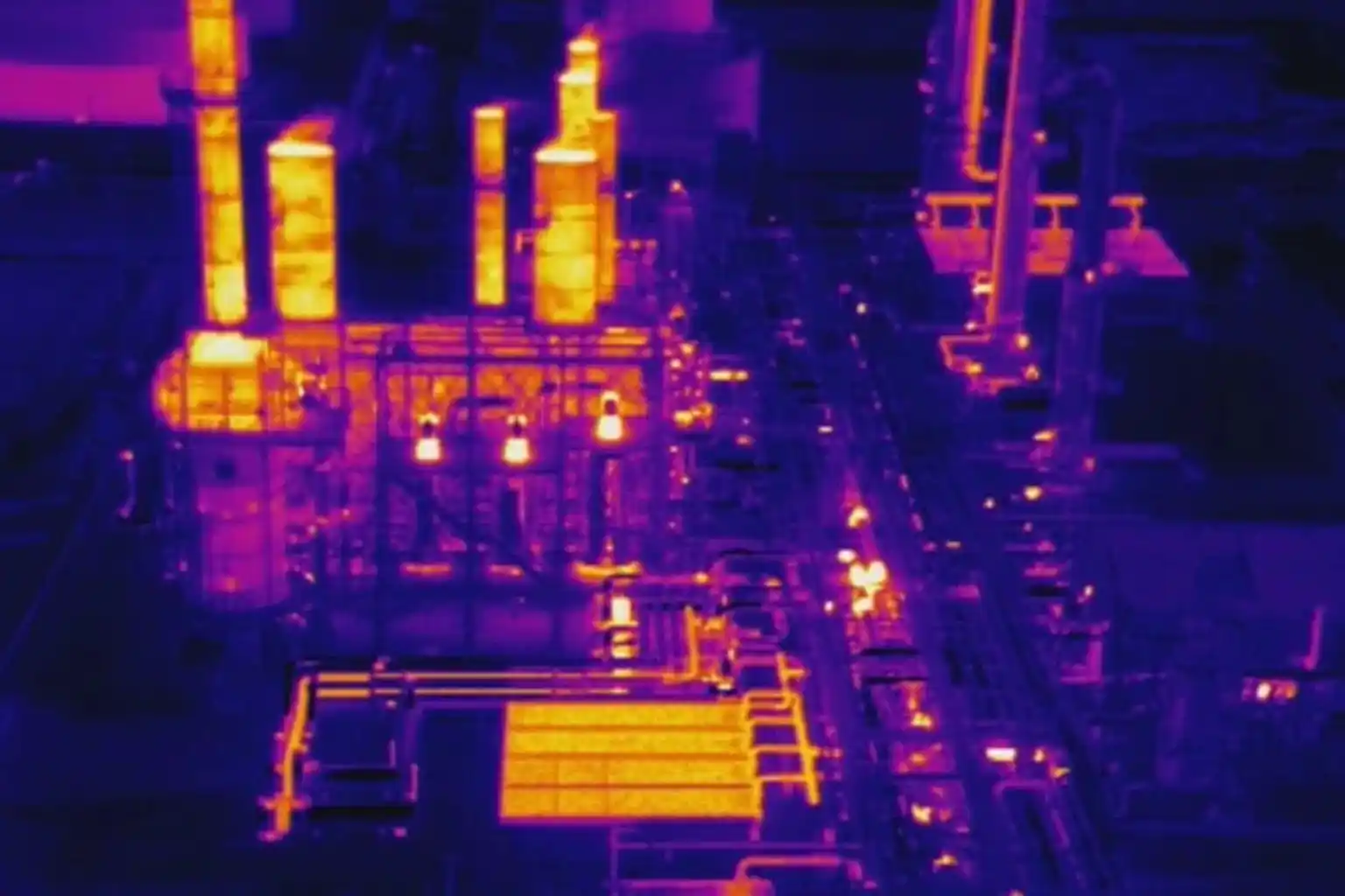
Methane is a critical target for regulators because it traps heat far more effectively than carbon dioxide. Detecting it requires speed and sensitivity.
- Technology: We utilize specialized industrial drones equipped with TDLAS (Tunable Diode Laser Absorption Spectroscopy) sensors and highly sensitive “sniffers.” These drones are programmed to fly automated, repeatable patterns around flare stacks, processing units, and extensive piping networks.
- The Shift to Quantification: In the past, inspections often just asked, “Is there a leak?” Now, the question is, “Exactly how much is leaking?” Our drone systems provide this quantitative data. They map the concentration of the gas plume in parts per billion. This precise data allows operators to calculate their exact carbon footprint.
- Safety Benefits: Traditionally, a technician would have to climb high structures to sniff for leaks, exposing them to fall risks and hazardous gas. Drones perform this dangerous work remotely, keeping humans safe while ensuring strict offshore environmental compliance.
II. From Below: Marine Impact Surveys
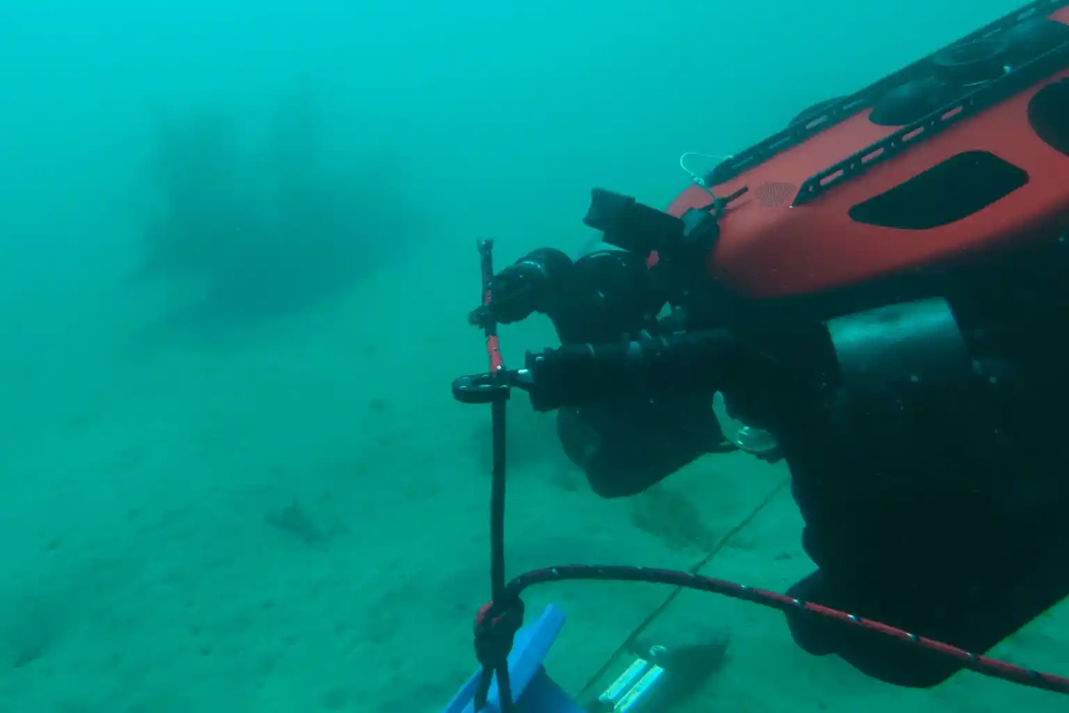
The responsibility of an operator extends all the way to the seafloor. Drilling operations produce cuttings and disturb sediment, which can impact local marine life.
- The Technology: We deploy Remotely Operated Vehicles (ROVs) equipped with High-Definition (HD) cameras, precise sediment samplers, and multibeam sonar.
- The Mission: These robots act as underwater environmental auditors. They map the seabed to monitor the spread of drill cutting piles. They inspect the health of coral reefs or marine life living on the platform jacket. They also use robotic arms to take physical sediment samples, which are analyzed in a lab to test for toxicity levels.
- The Value: This comprehensive seabed mapping provides undeniable proof of responsible stewardship. It protects the operator’s “license to operate” by verifying that subsea activities are within legal ecological limits.
Data-Driven Sustainability
Adopting robotic systems for environmental monitoring delivers business value that goes far beyond just “following the rules.”
III. Audit-Ready Data
In the world of compliance, data is everything. Regulators and auditors trust objective, digital records far more than manual logs. Robotic inspections provide a pristine digital audit trail. Every methane reading and every seabed photo is automatically timestamped and geotagged. This creates a transparent record of offshore environmental compliance that stands up to the toughest scrutiny.
IV. Safety and Cost Efficiency
Sustainability should not come at the cost of safety or profitability.
- Reducing Human Risk: Using UAVs and ROVs removes humans from the most hazardous zones. No personnel need to enter gas clouds or dive into deep, high-pressure water. This directly improves Health, Safety, and Environment (HSE) statistics.
- Lowering Costs: Traditional marine environmental surveys often require hiring massive, specialized vessels that cost hundreds of thousands of dollars per day. Small, agile ROV teams can perform the same sampling work from the platform itself or smaller support boats, drastically reducing the cost of compliance.
V. Reputation and Investment
Investors are increasingly prioritizing Environmental, Social, and Governance (ESG) criteria. An operator that can prove with hard data that they are minimizing methane leaks and protecting the ocean floor becomes a more attractive investment. High-fidelity environmental data positions the operator as a leader in the green energy transition, securing long-term stakeholder trust.
The Integrated Compliance Strategy
Turn offshore environmental compliance from a challenge into a competitive advantage. By integrating aerial and subsea robotics, you move from rough estimates to real-time, precise visualization of your entire environmental footprint.
Terra Drone Arabia is ready to deploy the advanced technology you need to protect your reputation and license to operate. Stop guessing and start verifying. Partner with us today and claim a FREE 3-month progress monitoring period, such as a methane baseline survey to experience the certainty of robotic precision.