Engineering the “Eyes” of Autonomous Flight with Digital Twin & Synthetic Vision

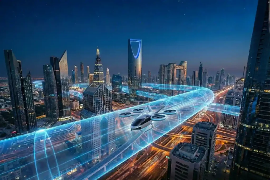
The Pilotless Revolution The future of urban transportation is not just in the air; it is autonomous. To realize the full potential of Advanced Air Mobility (AAM), air taxis must transition from human-piloted craft to fully autonomous systems capable of scaling across busy metropolitan centers. However, this transition faces a massive technical hurdle: the “urban canyon” effect. In dense cities like Riyadh or Dubai, traditional GPS-based navigation systems often fail because tall buildings block or reflect signals, leading to high positioning uncertainty. For a pilotless air taxi, a loss of GPS signal is more than an inconvenience. It is a critical safety risk. To solve this, the industry is engineering a hybrid intelligence layer that combines high-resolution digital twins with synthetic vision. These technologies act as the essential “eyes” of autonomous air taxi navigation, allowing vehicles to move with millimeter precision regardless of satellite availability or visibility conditions. How Autonomous Systems “See” Pilotless flight requires two distinct types of “vision”: a pre-loaded knowledge of the world (the map) and a real-time ability to navigate within it (the sensor). I. High-Resolution Photogrammetry: The “Reference Map” Before an air taxi even takes off, it needs a perfect 3D digital replica of its environment, a digital twin. Data Capture: Using specialized mapping drones, we capture thousands of overlapping high-resolution images of the urban landscape. 3D Reconstruction: Through photogrammetry, these 2D images are processed offline into highly accurate 3D textured mesh models. The Result: This provides the air taxi with a “geometric anchor,” a static world model that includes every building edge, helipad, and power line with centimeter-level accuracy. II. Visual SLAM: The “Real-Time Eye” While photogrammetry provides the map, Visual Simultaneous Localization and Mapping (Visual SLAM) provides the movement. GPS-Denied Precision: Onboard cameras extract distinctive “visual words” or features from the surrounding environment in real-time. Dynamic Mapping: As the taxi flies, it iteratively builds a sparse 3D point cloud of its path, comparing it instantly to its pre-loaded Digital Twin to correct for trajectory drift. Continuous Tracking: This allows the vehicle to determine its position and attitude (orientation) at the speed of acquisition, ensuring it stays on its designated path even without GPS. III. Synthetic vision Systems (SVS): The Virtual Cockpit synthetic vision is the technology that fuses the map and the sensor data into a 3D virtual representation of the external world. Intuitive Navigation: SVS takes terrain, obstacle, and traffic data and renders it as computer-generated imagery. Weather Independence: Because SVS relies on on-board databases and real-time sensor fusion rather than human eyesight, it remains fully functional in zero-visibility conditions like heavy fog, smoke, or total darkness. Building Trust in Autonomy For autonomous air taxi navigation to become the norm, it must prove it is safer than a human pilot. Trust is built through three layers of digital protection: Predictive Safety via digital twins: Operational digital twins (ODTs) allow for synthetic testing of unmanned traffic management. The system can simulate thousands of emergency scenarios like sudden engine failure or unexpected obstacles to refine how the autonomous autopilot will respond in the real world. 360-Degree Situational Awareness: While a human pilot has limited forward visibility, a synthetic vision system processes 360-degree data from visual, thermal, and LiDAR sensors simultaneously. This ensures the aircraft can detect and avoid other drones or birds long before they enter its immediate flight path. Reliability Through Sensor Fusion: The aircraft does not rely on a single data source. It tightly integrates Inertial Measurement Units (IMU), Visual SLAM, and healthy GPS signals (when available) to maintain stable flight even during extreme wind or equipment malfunctions. Operationalizing the Sky The pilotless revolution is no longer a distant dream, it is an engineering reality. The combination of photogrammetry-based digital twins and visual SLAM navigation is the cornerstone of safe, scalable autonomous air taxi navigation. The time to digitize is now, the sky-highways of 2030 are being mapped today. Without high-resolution digital infrastructure, the “eyes” of tomorrow’s air taxis will have nothing to see. Create the high-resolution digital twins required for autonomous navigation, ensuring your urban assets are ready for the first wave of commercial eVTOL flights.
Navigating the Future Air Transportation with Aerial Corridor Mapping
For decades, we have looked at the sky above our cities as an open, unstructured void. While our roads became congested and our ground-level infrastructure reached its physical limits, the airspace remained the “final frontier” for urban transport. However, as we move through 2026, that void is being filled. A quiet revolution is occurring just a few hundred feet above the pavement. The sky is being transformed into a structured, regulated, and highly efficient network of digital highways. In early 2025, the United Arab Emirates officially launched a groundbreaking national project to map aerial corridors specifically for air taxis and cargo drones. This initiative is not merely a pilot program; it is the fundamental construction of the infrastructure required for Advanced Air Mobility (AAM). By digitizing the airspace, the UAE is ensuring that the transition to electric vertical take-off and landing (eVTOL) aircraft is not only possible but inherently safe. The era of “free flight” is ending, and the era of aerial corridor mapping has begun. Just as the 20th century was defined by the expansion of the interstate highway system, the 21st century will be defined by our ability to map and manage the low-altitude corridors of the sky. Engineering the Vertical Highway Building a highway in the sky is significantly more complex than traditional road construction. You cannot simply paint lanes in the air; instead, you must engineer a high-resolution, three-dimensional digital framework that accounts for every physical and atmospheric variable. The ongoing aerial corridor mapping project led by the UAE’s General Civil Aviation Authority (GCAA) and the Technology Innovation Institute (TII) utilizes a sophisticated “technology stack” to create these invisible lanes. I. The High-Precision Technology Stack The engineering of these corridors relies on a multi-sensor approach to achieve sub-one-meter precision: LiDAR SLAM and Dense Point Clouds: Drones equipped with Light Detection and Ranging (LiDAR) and Simultaneous Localization and Mapping (SLAM) sensors generate 3D “point clouds,” millions of laser-measured coordinates that recreate the city’s geometry. Modern frameworks like FAST-LIO2 tightly integrate Inertial Measurement Unit (IMU) data to ensure accuracy even during rapid maneuvers. Visual SLAM and Photogrammetry: While LiDAR captures geometry, visual SLAM uses camera keyframes and feature detection to visually reconstruct the environment. Integrating these datasets produces photo-realistic digital twins that aid in “synthetic vision,” allowing autonomous air taxis to “see” and navigate accurately in poor visibility. Atmospheric Modeling: Unlike ground roads, air corridors are dynamic. TII uses advanced simulations to analyze 3D wind flow around skyscrapers and urban terrain. This is critical for defining flight safety boundaries and predicting how micro-currents might affect eVTOL stability. II. Defining Airspace Volumes and Safeguards The digital mapping process enables a rigorous vertical layering of the airspace to prevent congestion and accidents: Vertical Layering: Current trials are testing specific altitude tiers: 500–1,000 feet: A dedicated Safety Buffer Zone kept clear for emergency rerouting or response. 1,000–3,000 feet: The Air Taxi Cruise Zone, reserved for high-speed transit of passenger eVTOLs on fixed urban routes. Obstacle Evaluation Surfaces (OES): Leveraging GIS capabilities like ArcGIS Aviation, authorities can model Obstacle Limitation Surfaces (OLS). These are 3D volumes that must remain free of intruding objects like cranes or telecom towers. If a structure penetrates these digital boundaries, the system automatically triggers an aeronautical study to adjust the corridor. III. Real-Time Autonomous Intelligence The ultimate goal of aerial corridor mapping is to feed data into AI-powered control and communication algorithms. These systems enable real-time decision-making for autonomous aircraft, ensuring they can optimize routes and avoid collisions with other unmanned traffic systems (UTM). This creates a seamless, connected multimodal network that integrates ground, waterways, and skies into a single transportation ecosystem. Transforming Urban Living and Economics The drive for aerial corridor mapping is fueled by a desire to fundamentally transform the economic and social fabric of urban environments. As we enter 2026, Advanced Air Mobility (AAM) has transitioned from a demonstrative concept into a “commercially bankable” aviation sub-sector. By establishing these sky-highways, the Middle East and specifically the UAE is positioning itself as the undisputed global reference case for the trillion-dollar low-altitude economy. I. Unlocking The $87B Logistics Market The economic potential of a mapped airspace is staggering, with the global AAM market projected to grow from $11.4 billion in 2024 to over $87 billion by 2034. Heavy-Lift Cargo Dominance: Cargo drones represent the earliest and most dominant segment of this growth, valued at approximately $1.2 billion in 2024 and expected to reach $6.3 billion by 2034. These systems enable rapid, eco-friendly logistics for high-value, time-sensitive goods, such as medical supplies and perishables across infrastructure-challenged regions. Operational Efficiency: By bypassing traditional ground traffic, which cost major urban centers like New York nearly $74 billion in lost productivity annually, AAM offers a scalable solution to congestion. II. The Premium Mobility Economy In March 2026, Dubai is set to launch its first operational vertiport, initiating a rapid transit network for air taxis. This “verticalization” of the airspace allows for unprecedented travel speed: Time Recovery: eVTOL aircraft, such as the Archer Midnight or Joby models, can condense a 60–90 minute ground commute into a 10–15 minute aerial transit. Multimodal Integration: Modern vertiports are designed to integrate seamlessly into the urban landscape, utilizing rooftops, parking structures, and water facilities to connect with existing rail, car, and airport hubs. This multimodal connectivity ensures AAM complements rather than replaces existing infrastructure, facilitating both urban and rural economic growth. III. Infrastructure Precedent and Asset Value For developers and giga-project stakeholders, the mapping of aerial corridors creates a new “premium mobility” tier in real estate: Digital Infrastructure Investment: By formalizing standards ahead of other global jurisdictions, the UAE reduces uncertainty for manufacturers, insurers, and infrastructure investors. Licensing and Employment: The expansion of these networks is expected to result in tens of thousands of new jobs in manufacturing, maintenance, and autonomous operations, stimulating long-term capital formation. Safety and public acceptance remain the primary catalysts for this desire. The public will only embrace AAM if it feels as safe as traditional transport. High-fidelity data from
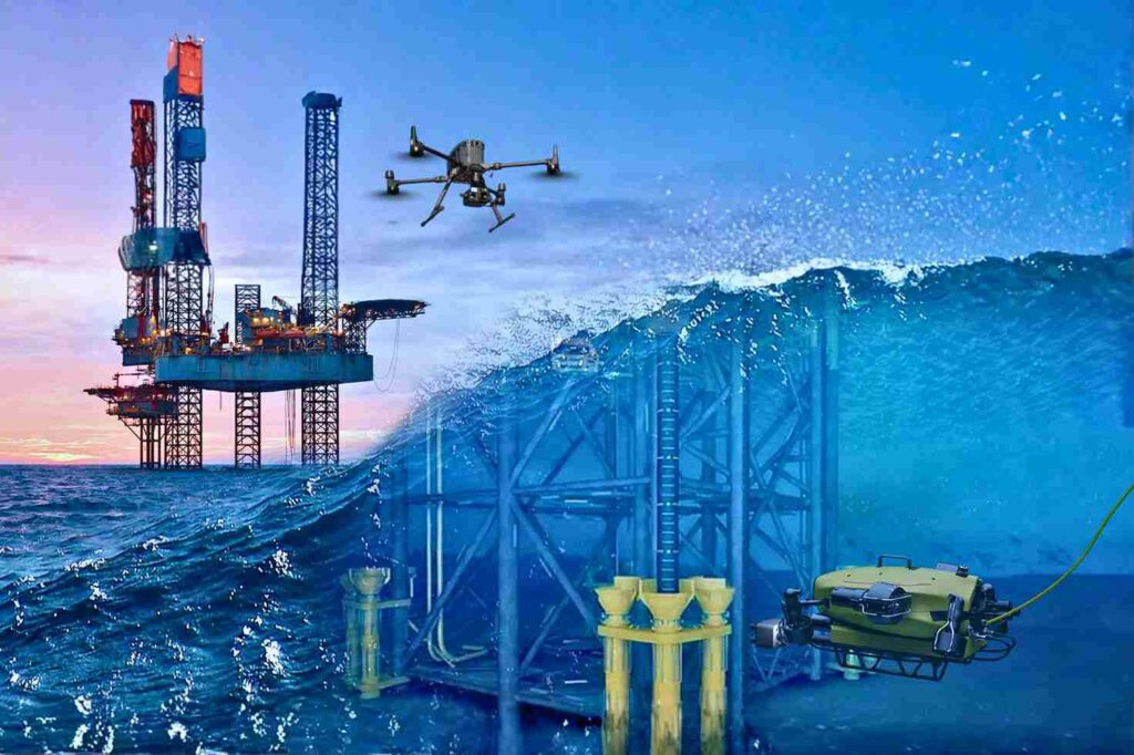
Securing Marine Assets with ROV Inspection and Subsea NDT.
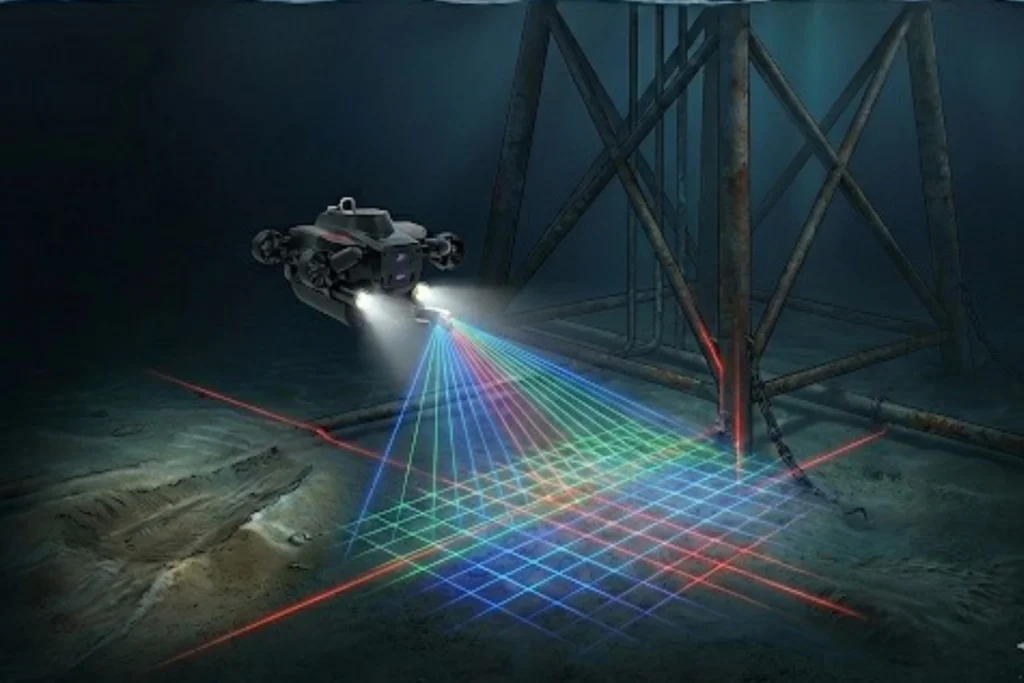
While the world marvels at the soaring skyscrapers of Riyadh and the mirrored walls of NEOM, a second, equally ambitious infrastructure revolution is taking place beneath the waves. Saudi Arabia’s maritime infrastructure, spanning the Red Sea and the Arabian Gulf is home to a vast, invisible network of subsea lifelines, including oil and gas pipelines, high-voltage power cables, and critical communication links. However, this underwater world is a hostile environment. In these harsh maritime zones, infrastructure faces constant threats from aggressive saltwater corrosion, intense pressure, and biofouling. Traditional manual diving, while historically necessary, cannot keep pace with the scale of Vision 2030’s coastal giga-projects. It is slow, limited by depth, and carries high physical risk to personnel. The high cost of failure in these zones, ranging from environmental disasters to billion-dollar energy shutdowns demands a technological shift. The transition from human-led diving to subsea robotics in Saudi Arabia is no longer just an upgrade; it is an essential requirement for the long-term integrity of the Kingdom’s offshore and coastal assets. The Technology of the Deep The core of this revolution is the Remotely Operated Vehicle (ROV). These inspection-class robots act as the eyes and hands of engineers in environments where humans simply should not go. From Divers to ROVs: Unlike human divers, ROVs can operate 24/7 at depths exceeding hundreds of meters, unaffected by the physiological limits of pressure or oxygen. Advanced Sensing and Vision: Modern ROVs utilize high-definition visual imaging and multibeam sonar to navigate and “see” even in the silty, low-visibility conditions of the seabed. Quantitative Corrosion Mapping: Specialized ROVs are equipped with Ultrasonic Thickness (UT) gauges and cathodic protection (CP) probes. These tools allow for precise, contact-based measurements of metal thickness and electrical potential, identifying thinning pipe walls long before a leak occurs. Integrated Frameworks: Terra Drone Arabia (TDSA) has pioneered a unified framework that merges subsea ROV data with aerial UAV and terrestrial scans. This provides asset owners with a single, holistic view of their infrastructure from the seabed to the sky. Securing Coastal and Offshore Assets The deployment of subsea robotics in Saudi Arabia serves as the primary defense for the Kingdom’s most valuable maritime investments. Offshore Oil & Gas Integrity: Routine monitoring of platform jackets, risers, and subsea production systems is vital. ROVs detect structural fatigue and weld defects early, ensuring compliance with global safety standards and preventing catastrophic failures in the Arabian Gulf. Coastal Giga-Projects (NEOM & The Red Sea): As the Red Sea project and NEOM expand, maintaining the integrity of underwater jetties, desalination intakes, and luxury coastal structures is paramount. ROVs monitor these assets while simultaneously conducting environmental surveys to protect the Kingdom’s precious coral reefs. Data-Driven Longevity: Every dive generates a digital trail. By building Digital Twins from ROV data, engineers can perform predictive maintenance. This allows operators to simulate structural degradation and extend the lifespan of multi-billion dollar assets through precisely timed interventions. Diving into the Digital Future The future of marine asset management in the Kingdom is undeniably robotic. The precision, safety, and scalability offered by subsea robotics in Saudi Arabia provide the foundation for the next decade of maritime development. Terra Drone Arabia is leading this transition, bringing global robotic expertise to the Kingdom’s local shores. We integrate cutting-edge ROV technology with advanced data analytics to ensure your subsea assets remain secure and compliant. Don’t complex your underwater inspection. Contact us for your marine infrastructure and experience the certainty of digital subsea integrity.
The 2025 Recap from Terra Drone Arabia
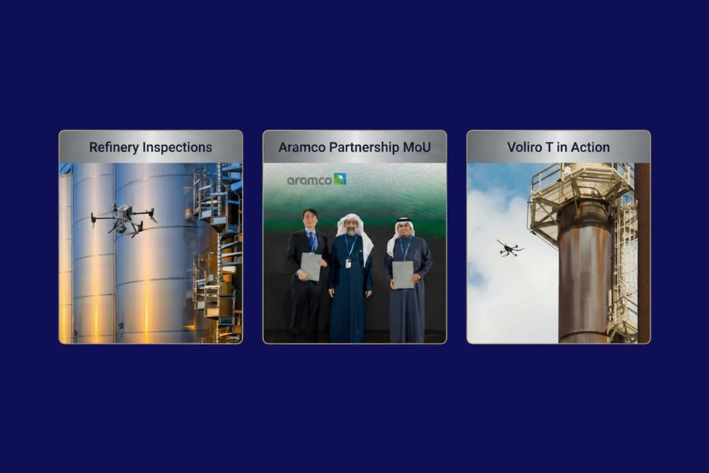
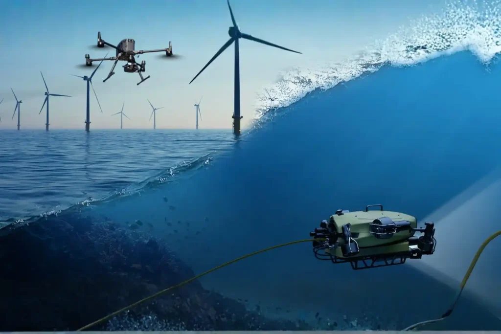
As the curtain falls on 2025, the industrial landscape of Saudi Arabia stands fundamentally altered. What was once a horizon dominated by traditional manual labor and terrestrial surveying has transitioned into a high-velocity, data-driven domain known as the Low Altitude Economy (LAE). At the heart of this revolution is Terra Drone Arabia (TDSA). This Terra Drone Arabia 2025 recap serves not just as a history of the past twelve months, but as a roadmap for how unmanned aerial systems (UAS) have become the bedrock of the Kingdom’s industrial. Throughout 2025, TDSA moved beyond the role of a simple service provider to become a strategic architect of the Saudi digital ecosystem. From the deep shafts of mineral exploration in the Hijaz mountains to the complex flare stacks of Eastern Province refineries, Terra Drone’s influence was ubiquitous. It was a year defined by three core pillars: localization, technical integration, and a relentless commitment to the goals of Saudi Vision. Q1: Localization and Standardization The year began with an aggressive focus on two sectors critical to the Kingdom’s diversification: energy and mining. In January, TDSA demonstrated its deep-rooted commitment to the Saudi workforce and supply chain at the 10th iktva Forum & Exhibition 2025. This event served as a public declaration that TDSA is not just operating in Saudi Arabia; it is of Saudi Arabia, focusing on local talent development and technological sovereignty. Simultaneously, the Future Minerals Forum 2025 showcased how drone solutions are no longer “optional extras” but are now the new industry standard in mining. By integrating satellite imagery with modern mining workflows, TDSA enabled explorations to move at a pace previously thought impossible, achieving results up to eight times faster than conventional. February shifted the focus toward the “City of the Future.” At the Al Ahsa Forum, TDSA unveiled how smart city drones are essential for the urban development of the East. The narrative of February was one of “Smart Urbanism,” where UAVs are used not just for mapping, but as the sensory nervous system of emerging smart. Q2: Strategic MoUs and Educational Initiatives If Q1 was about showcasing technology, Q2 was about institutionalizing it. March and April were dominated by a historic milestone: Terra Drone signing a Memorandum of Understanding (MoU) with Saudi Arabia. This agreement was a seismic shift in the regional tech landscape, designed to drive innovation and localization in drone technology specifically for the global energy. However, innovation is useless without a skilled workforce to operate it. In May, TDSA and the ITQAN Institute signed an MoU to launch specialized drone inspection training. This initiative ensured that the next generation of Saudi engineers is equipped to handle advanced assets like the Voliro T, a drone capable of performing Non-Destructive Testing (NDT) at heights, potentially saving operators millions in. By the end of the quarter, the conversation moved toward ESG (Environmental, Social, and Governance) excellence. TDSA began advocating for drone monitoring as the “fast-track” to achieving safety and environmental goals, emphasizing that a digitized asset is a safer and more sustainable. Q3: Scaling Infrastructure and Global Distribution As the summer months arrived, the scale of operations reached new heights. June and July saw TDSA positioning drones as a core pillar of Vision 2030’s infrastructure. The company proved that aerial surveillance could save up to 95% of traditional costs in large-scale monitoring. A major highlight of this period was the global rollout of the Terra Xross 1, a Japan-made indoor inspection. Through distribution agreements with partners in Taiwan, Chile, and beyond, TDSA’s influence as a global hub for indoor inspection technology was. This was not merely about international sales; it was about proving that technology vetted in the harsh industrial environments of Saudi Arabia is world-class. In August, TDSA tackled the challenge of renewable energy. By utilizing drone topographic surveys, the company demonstrated a reduction in renewable energy site preparation time by up to 90%. This speed is essential for the Kingdom as it races toward its ambitious green energy targets. Furthermore, the introduction of the DJI Dock solution showed city planners how to save 30% of surveillance budgets through automation and persistent aerial presence18. Q4: The Rise of Integrated Inspection Frameworks The final months of 2025 witnessed a shift from individual drone flights to holistic asset management. In October and November, TDSA moved the goalposts by introducing an integrated aerial, terrestrial, and marine inspection. This approach acknowledges that industrial asset integrity does not end at the waterline or the ground level; it requires a unified view of the entire. One of the most technically impressive feats discussed in November was the rise of ROV-based monitoring for marine. By combining subsea ROV data with aerial UAV data, TDSA created the ultimate “Digital Twin,” a 3D roadmap for highway construction, mining, and offshore energy that allows for near-real-time decision. The year concluded with a focus on safety and compliance. TDSA’s global group company, Unifly, completed trials on collision avoidance and safe flight separation, ensuring that as the skies of Saudi Arabia become more crowded with drones, they remain. This technical groundwork is what allows for the rise of the economy under 1,000 feet, turning the sky into a productive industrial. Technical Deep Dive: The Evolution of Autonomous Systems To understand why 2025 was so successful, one must look at the specific technologies that matured during this period. UTM (Unmanned Traffic Management): TDSA emphasized that UTM systems are the primary driver of flight safety and compliance, paving the way for scalable drone operations across the Middle. BVLOS (Beyond Visual Line of Sight): The ability to fly long-distance corridors for power transmission and pipelines became a reality, improving project timelines. LiDAR and Photogrammetry Integration: By revolutionizing land surveying with integrated LiDAR, TDSA enabled topographic mapping of 124 km² in just one month, a feat that would take traditional teams years to. NDT (Non-Destructive Testing): The shift to drone-based visual and ultrasonic thickness (UT) systems revolutionized corrosion inspection, allowing for inspections of live flare stacks and storage tanks without cost. The
Quantifying the Invisible: Autonomous Equipment for Total Environmental Oversight.
The Regulatory Squeeze Offshore energy operators today face a dual threat that is often invisible to the naked eye. The first threat is leaking methane gas in the air, a potent greenhouse gas. The second is ecological damage on the seabed beneath the platform. For decades, these impacts were estimated using calculations or infrequent spot checks. That era is over. Global regulations are tightening rapidly. Frameworks like the oil and gas methane partnership 2.0 (OGMP 2.0) now demand precise measurement of emissions, not just theoretical estimates. Operators must prove exactly how much gas is leaving their facility. Simultaneously, strict marine protection laws require concrete proof that drilling activities are not harming local coral reefs or sediment layers. This creates a high-stakes pressure cooker for asset managers. Failing to meet these standards can result in massive fines, legal action, and severe reputational damage. Traditional methods of environmental monitoring like handheld sniffers or large, expensive survey vessels are too slow and too costly to provide the continuous data required today. The industry needs a new strategy. It requires a continuous, quantified approach to offshore environmental compliance. This strategy must utilize advanced robotic systems to verify integrity from the top of the flare stack to the bottom of the ocean. The Technology of Verification To manage what you cannot see, you need the right tools. We deploy a coordinated system of aerial and subsea robotics to measure these invisible environmental factors with absolute precision. I. From Above: Aerial Methane Quantification Methane is a critical target for regulators because it traps heat far more effectively than carbon dioxide. Detecting it requires speed and sensitivity. Technology: We utilize specialized industrial drones equipped with TDLAS (Tunable Diode Laser Absorption Spectroscopy) sensors and highly sensitive “sniffers.” These drones are programmed to fly automated, repeatable patterns around flare stacks, processing units, and extensive piping networks. The Shift to Quantification: In the past, inspections often just asked, “Is there a leak?” Now, the question is, “Exactly how much is leaking?” Our drone systems provide this quantitative data. They map the concentration of the gas plume in parts per billion. This precise data allows operators to calculate their exact carbon footprint. Safety Benefits: Traditionally, a technician would have to climb high structures to sniff for leaks, exposing them to fall risks and hazardous gas. Drones perform this dangerous work remotely, keeping humans safe while ensuring strict offshore environmental compliance. II. From Below: Marine Impact Surveys The responsibility of an operator extends all the way to the seafloor. Drilling operations produce cuttings and disturb sediment, which can impact local marine life. The Technology: We deploy Remotely Operated Vehicles (ROVs) equipped with High-Definition (HD) cameras, precise sediment samplers, and multibeam sonar. The Mission: These robots act as underwater environmental auditors. They map the seabed to monitor the spread of drill cutting piles. They inspect the health of coral reefs or marine life living on the platform jacket. They also use robotic arms to take physical sediment samples, which are analyzed in a lab to test for toxicity levels. The Value: This comprehensive seabed mapping provides undeniable proof of responsible stewardship. It protects the operator’s “license to operate” by verifying that subsea activities are within legal ecological limits. Data-Driven Sustainability Adopting robotic systems for environmental monitoring delivers business value that goes far beyond just “following the rules.” III. Audit-Ready Data In the world of compliance, data is everything. Regulators and auditors trust objective, digital records far more than manual logs. Robotic inspections provide a pristine digital audit trail. Every methane reading and every seabed photo is automatically timestamped and geotagged. This creates a transparent record of offshore environmental compliance that stands up to the toughest scrutiny. IV. Safety and Cost Efficiency Sustainability should not come at the cost of safety or profitability. Reducing Human Risk: Using UAVs and ROVs removes humans from the most hazardous zones. No personnel need to enter gas clouds or dive into deep, high-pressure water. This directly improves Health, Safety, and Environment (HSE) statistics. Lowering Costs: Traditional marine environmental surveys often require hiring massive, specialized vessels that cost hundreds of thousands of dollars per day. Small, agile ROV teams can perform the same sampling work from the platform itself or smaller support boats, drastically reducing the cost of compliance. V. Reputation and Investment Investors are increasingly prioritizing Environmental, Social, and Governance (ESG) criteria. An operator that can prove with hard data that they are minimizing methane leaks and protecting the ocean floor becomes a more attractive investment. High-fidelity environmental data positions the operator as a leader in the green energy transition, securing long-term stakeholder trust. The Integrated Compliance Strategy Turn offshore environmental compliance from a challenge into a competitive advantage. By integrating aerial and subsea robotics, you move from rough estimates to real-time, precise visualization of your entire environmental footprint. Terra Drone Arabia is ready to deploy the advanced technology you need to protect your reputation and license to operate. Stop guessing and start verifying. Partner with us today and claim a FREE 3-month progress monitoring period, such as a methane baseline survey to experience the certainty of robotic precision.
The Involvement of the UAV and ROV in Offshore Industry
Offshore Operations in a High-Risk, Data-Driven Era The offshore energy sector operates on the edge of what is physically possible. Platforms stand isolated in the middle of the ocean, battered by saltwater, high winds, and unpredictable currents. In this hostile environment, the challenge of maintaining infrastructure is immense. Steel corrodes faster, structural fatigue sets in deeper, and the complexity of subsea networks makes monitoring a logistical nightmare. For decades, operators accepted high risk as the cost of doing business. Maintaining these assets meant sending rope-access technicians dangling from flare tips or deploying human divers into dark, crushing depths. These traditional methods are slow, incredibly expensive, and dangerously reliant on human physical endurance. Today, facing strict environmental regulations and the need for operational efficiency, these old ways are no longer sustainable. The industry requires a fundamental shift. This shift is defined by the role of UAV and ROV in offshore industry. Unmanned Aerial Vehicles (UAVs) and Remotely Operated Vehicles (ROVs) are no longer just supplementary tools; they are critical enablers. They act as the eyes and hands of the operator in environments where humans simply should not go. By adopting these robotic systems, offshore operators can finally meet modern requirements for speed, accuracy, and absolute risk reduction. How UAV and ROV Systems Transform Offshore Asset Management The transformation is comprehensive. It covers the asset from the tip of the flare stack in the sky to the pipeline buried in the seabed. I. Surface-Level Inspection with UAVs The topside of an offshore platform is a dense maze of piping, cranes, and high-voltage equipment. UAVs (drones) revolutionize how we inspect these diverse components. Visual and Thermal Precision: We use high-resolution cameras to capture millimeter-level details of rust or loose bolts on crane booms and drilling derricks. Simultaneously, thermal sensors detect insulation breaks or overheating electrical components without requiring a shutdown. Flare Stack Safety: Inspecting a live flare stack is one of the most dangerous jobs offshore. Drones can fly close to the flame, using zoom lenses and thermal imaging to check the tip’s condition while the facility remains in full production. This application alone saves millions in potential shutdown costs. Contact NDT: Advanced drones, like the Voliro T, go beyond looking. They can fly up to a vertical pipe or storage tank wall and press an ultrasonic probe against it. This allows for Non-Destructive Testing (NDT) at height, measuring wall thickness to detect internal corrosion without building a single scaffold. II. Subsea Inspection and Monitoring with ROVs Below the waterline, the environment is even more unforgiving. ROVs are the essential workhorses for subsea integrity. Structural Integrity: ROVs inspect the massive steel jackets and mooring chains that hold the platform in place. They clean off marine growth to inspect welds and check the status of sacrificial anodes, ensuring the cathodic protection system is working to stop corrosion. Pipeline and Riser Inspection: Subsea pipelines are the lifelines of the operation. ROVs travel kilometers along the seabed, using sonar and video to check for leaks, free spans (where the pipe is unsupported), or damage from anchors. Operational Support: During drilling operations, ROVs act as the “eyes” for the drill team, monitoring the blowout preventer (BOP) and subsea trees to ensure every connection is secure. III. Environmental Compliance and Emission Monitoring Regulatory pressure is increasing globally. Operators must prove they are not harming the environment. The role of UAV and ROV in offshore industry is central to this compliance. Aerial Methane Detection: Drones equipped with sensitive gas detectors fly autonomous patterns around the platform to sniff out methane leaks. They quantify Greenhouse Gas (GHG) emissions with a precision that handheld sensors cannot match, ensuring compliance with strict environmental standards like OGMP 2.0. Seabed Impact: ROVs perform environmental surveys of the seabed, taking sediment samples and mapping the area to ensure drilling activities are not damaging local marine ecosystems. IV. Operational Efficiency and HSE Improvements The most immediate impact of this technology is on Health, Safety, and Environment (HSE) metrics. Removing People from Harm: Every hour a drone spends inspecting a riser is an hour a human does not spend hanging over the water. Every hour an ROV spends checking a weld is an hour a diver does not spend under pressure. Reducing Logistics: Traditional inspections often require hiring specialized support vessels (DSVs) or accommodation barges for large crews. Robotic inspection teams are small and agile, drastically reducing the logistical footprint and cost of the campaign. Why Offshore Operators Are Accelerating UAV & ROV Adoption The move to robotic inspection is driven by hard data and financial reality. V. Improved Data Accuracy and Frequency High-Density Data: Drones do not just take photos; they capture LiDAR data. This laser scanning creates a dense 3D point cloud of the entire topside, allowing engineers to measure distances and plan modifications with centimeter accuracy. Sonar Clarity: In murky water, human divers are blind. ROVs use multibeam sonar to “see” through the silt, creating perfect acoustic images of subsea assets. Frequency: Because robotic inspections are cheaper and faster, operators can perform them more often. Instead of a major survey every five years, you can inspect critical nodes annually, catching problems before they become failures. VI. Lower Operational Cost and Downtime No Shutdowns: The ability to inspect live assets—like flares and operating risers—means production continues uninterrupted. The value of avoiding a single day of shutdown often pays for the entire inspection program. Speed: Drone inspections can reduce the time required for visual surveys by up to $50-$75 compared to rope access methods. This efficiency frees up bed space and resources on the platform for other critical maintenance tasks. VII. Enhanced Safety and Regulatory Compliance Zero Confined Space Entry: For internal inspections of tanks or vessels on FPSOs (Floating Production Storage and Offloading units), we use specialized caged drones like the Terra Xross 1. These fly inside the dark, hazardous tank while the pilot stays safely outside, completely eliminating the risk of confined space entry. Audit Trails: Robotic data is objective. It provides a
Autonomous Maintenance: How the low altitude economy Will Inspect NEOM’s The Line in 2026
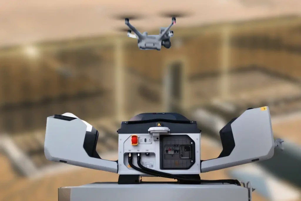
The Density Challenge When we talk about NEOM’s The Line, we are not discussing a standard skyscraper. We are talking about a continuous, 170km-long structure where structure and facilities are bound together in a straight, vertical line. Unlike traditional cities where utilities are spread out horizontally, The Line compresses everything from energy, water, transport, and structural beams into a tight, stacked footprint. This creates a unique maintenance nightmare: overlapped utilities and narrow, vertical corners that are impossible for humans to access safely. In this dense environment, a single pipe failure can cascade into critical electrical systems because they are “gathered” so closely together. Traditional maintenance methods like hanging platforms are too bulky and slow for these confined, high-tech corridors. The solution is not “more people.” It is a new layer of infrastructure. This is the low altitude economy, a dedicated digitized airspace where specialized autonomous robots navigate the tight gaps and vertical shafts to inspect, clean, and maintain the city without human intervention. The Invisible Maintenance Layer In 2026, the maintenance system of The Line will operate as a “Drone Hive,” seamlessly integrated into the building’s spine to handle the complex, gathered infrastructure. I. The Drone Hive (Advanced Docking Stations) Imagine a network of autonomous stations, such as the next-generation DJI Dock 3 (conceptually evolving from the current Dock 2), embedded directly into the utility layers of the megastructure. These compact, weather-proof stations act as home bases. At night or during low-traffic hours, drones automatically deploy to scan the narrow vertical shafts, creating a persistent cycle of monitoring that no human crew could match. II. Navigating the Narrow Corners The Line’s design creates deep, narrow recesses where utilities overlap. Standard drones cannot fly safely in these confined, GPS-denied zones. The solution is the Voliro T. Omnidirectional Flight: Unlike standard drones, the Voliro T uses tiltable rotors to fly in any orientation. It can hover sideways or upside down to navigate the tight corners between a water pipe and a structural beam. Contact Inspection: It can press a probe against a pipe buried deep in a vertical shaft to test for corrosion or sealant failure, ensuring integrity even in the most crowded utility zones. From Inspection to Intelligence The true power of this system isn’t just flight; it’s the ability to untangle the complexity of bound facilities. We are moving from simple inspection to predictive maintenance. III. Predictive Maintenance In a structure where facilities are gathered so tightly, you cannot wait for a leak to happen. The system uses predictive maintenance to analyze the “overlapped” layers of the building. Thermal Scanning: Drones fly the vertical corridors, using thermal sensors to “see” through the layers. They can detect a cooling leak behind a wall panel or an overheating cable tray hidden by a structural beam. The Digital Twin: Every byte of data feeds into NEOM’s Digital Twin. Because the structure and facilities are bound together, the Twin can predict how a vibration in the rail line might affect the plumbing stack next to it. It logs defects, identifies the exact replacement part for that specific narrow corner, and schedules the repair before a failure occurs. IV. Safety & Aesthetics By eliminating bulky external cranes, we preserve the sleek aesthetic of The Line. More importantly, using drones for these narrow, vertical corners removes the risk of sending personnel into confined, high-altitude utility shafts. It turns a high-risk job into a supervised digital workflow. Proving the Concept Today The technology to maintain the vertical cities of the future exists today. It just needs to be scaled. The low altitude economy is not science fiction; it is the operational standard for 2026. You can deploy these autonomous workflows on your current high-rise assets right now to reduce costs and risk and get a FREE 3-month progress monitoring period through talking to our expert.
Milestones to Watch in 2026 as Saudi Arabia Advances Vision 2030
The Year of Realization For the past seven years, the world has watched Saudi Arabia move earth and sand on a scale never seen before. We have witnessed the largest construction sites in history, from the mountains of Trojena to the coasts of the Red Sea. But as we approach 2026, the narrative is changing. 2026 is the tipping point. It is the year where “artist renderings” transform into “operational assets.” It is the year where the dust settles, and the cities come to life. This transition presents a new, critical challenge for developers and government entities. The focus shifts from “How do we build it fast?” to “How do we keep it running perfectly?” Achieving these Saudi Vision 2030 milestones requires a fundamental pivot in technology. We must move from construction support to operational intelligence. The tools that built the cities, such as drones, LiDAR, and digital models are now the tools that will sustain them. The stakes in 2026 are incredibly high. The Kingdom will not just be building; it will be hosting. With major global events on the horizon and tourists arriving, the reliability of infrastructure becomes the new currency. A failed air conditioning unit in a luxury resort or a structural issue in a theme park is no longer just a “snag list” item; it is an operational failure. To prevent this, asset managers must adopt a proactive, data-driven approach to maintenance immediately. The Deliverables of 2026 To understand the scale of the challenge, we must look at what is coming online. The sheer volume of infrastructure being delivered in 2026 is staggering, and each project brings unique maintenance demands. I. NEOM: The Vertical Challenge By 2026, the NEOM region will see significant activity. While the full 170km of The Line is a long-term goal, early segments and the luxury island of Sindalah will be operational or nearing advanced stages. This introduces a unique problem: inspecting vertical infrastructure. Traditional maintenance crews cannot easily abseil down a 500-meter mirrored facade to check for cleaning needs or structural stress. The Saudi Vision 2030 milestones for NEOM depend on autonomous aerial systems, drones that scan the exterior continuously, detecting defects without human risk. Furthermore, the energy infrastructure powering these zones must be flawless. NEOM’s commitment to 100% renewable energy means that solar farms and wind turbines must operate at peak efficiency. Dust accumulation or a single damaged blade can disrupt the energy grid. Manual inspection in the desert heat is inefficient. Autonomous drones will become the primary inspectors, ensuring the city of the future remains powered. II. Red Sea Global: The Coastal Challenge The Red Sea destination is moving fast. After the opening of the first resorts in 2024 and 2025, the year 2026 sees the expansion of Shura Island, with eight additional resorts slated for completion. This shifts the focus to marine integrity. Hotels sitting over the water and subsea assets face constant corrosion and biofouling. Maintaining the pristine nature of these sites is non-negotiable. This requires robotic inspection, ROVs underwater, and drones in the air to monitor the environment and the assets simultaneously without disturbing the ecosystem. The Saudi Vision 2030 milestones here are about balancing luxury with ecology. Any leak or structural failure could damage the coral reefs that attract tourists. Therefore, the inspection technology must be non-intrusive and highly accurate. III. Qiddiya City: The Entertainment Challenge Qiddiya City has announced that its flagship theme park, Six Flags Qiddiya, will open on December 31, 2025. This makes 2026 its first full year of operations. This is a massive milestone. The park features record-breaking rides like Falcons Flight. The safety requirements for such high-performance machinery are extreme. Managers cannot rely on slow, manual checks for rides that travel at 250 km/h. They need real-time structural health monitoring. Drones equipped with high-zoom cameras and thermal sensors can inspect the high tracks of roller coasters before the park opens each day. They can verify that every bolt and weld is secure. This ensures that the thrill remains safe, protecting the reputation of the Kingdom’s entertainment sector. IV. Diriyah and Urban Heritage In Riyadh, the Diriyah Gate project continues to expand. By 2026, new luxury hotels like the Aman Wadi Safar are expected to open. This project is unique because it blends modern luxury with delicate mud-brick heritage architecture. The maintenance challenge here is preservation. Heavy cleaning equipment or standard industrial inspection tools might damage the historic surfaces. Drones offer a “touchless” inspection method. They can scan the heritage sites to detect water damage, erosion, or structural shifts to the millimeter without ever physically touching the ancient walls. This preserves the history while ensuring the safety of the modern guests inside. The Operational Tech Stack How do we manage assets of this complexity? The answer lies in the “Digital Handover.” We must carry the high-precision data collected during construction into the operational phase. V. From BIM to Digital Twin During construction, we used drones to create precise BIM (Building Information Modeling) files to guide the builders. In 2026, this data transforms into a Digital Twin. This is a live, virtual replica of the city. When a drone inspects a building in 2026, it updates the Digital Twin. Facility managers can sit in a control room and see the exact condition of a solar panel or a water pipe in 3D. They don’t just see a maintenance ticket; they see the asset’s history and its future. For example, if a drone detects a crack in a facade at The Line, the Digital Twin can instantly show the managers what materials are needed for the repair, how to access the area safely, and how critical the damage is. This speed of information is vital for maintaining the seamless experience promised by Vision 2030. VI. Autonomous “Smart” Inspection (Low Altitude Economy) Manual maintenance cannot scale to meet Saudi Vision 2030 milestones. There are simply too many assets and not enough inspectors. The future is the low altitude economy. Imagine autonomous drone docks
Precise Prediction: Low Altitude Economy Aerial Data for Digital Twin Infrastructure.

The Urban Data Gap Smart cities like NEOM or Riyadh are not just collections of concrete and glass. They are complex, living systems that breathe, move, and consume energy. Managing such complexity requires real-time intelligence. Yet, many city planners still rely on static ground surveys and outdated maps. They cannot see how a new skyscraper might block airflow or how a road expansion will truly affect traffic until construction is finished. This data gap creates a blind spot that leads to costly errors. The solution lies in the sky. The low altitude economy, the active layer of airspace below 1,000 feet offers a continuous stream of high-resolution aerial data. This data is the fuel that builds the essential digital twin infrastructure for modern urban management. By moving from static maps to dynamic aerial insights, we can predict the future of our cities before we pour the first cubic meter of concrete. Capturing the City in High-Definition To manage a smart city, you must first measure it. Drones act as the sensory layer of the modern metropolis, capturing the physical world in minute detail. I. The Aerial Sensor Network We deploy drones equipped with advanced remote sensing toolkits. These are not just cameras; they are sophisticated instruments. LiDAR sensors shoot laser pulses to measure the exact height of buildings and trees. Thermal cameras detect heat leaks in pipelines and buildings. Multispectral sensors analyze the health of urban green spaces. This network captures the physical city with a level of detail that ground crews simply cannot match. II. 3D City Modeling and Integration This raw data is transformed into precise 3D models. We map every street corner, utility pole, and building facade. This creates the accurate geometric base of your digital twin infrastructure. But data alone is not enough. It must be organized. We build high-resolution maps and GIS databases to store this influx of information. The critical step is integration: ensuring data flows seamlessly from the drone to the database. This creates a “living” map that updates constantly, rather than a static snapshot that expires in a month. Simulating the Future When you have a living digital model, you gain the power of simulation. This is where data turns into decision-making power for city leaders. III. Urban Simulation and Planning Digital twin infrastructure allows planners to test ideas in a virtual world. You can simulate traffic flow during rush hour to test a new intersection design. You can model wind patterns to see how a new tower will affect pedestrian comfort. You can even simulate energy usage across a district to optimize the power grid. This predictive capability removes the guesswork from urban planning. IV. Environmental and Project Management The benefits extend to the environment. Drones monitor air quality sensors and detect urban “heat islands” areas that become dangerously hot. This data helps planners design cooler, healthier parks and living spaces. For the massive giga-projects driving Vision 2030, speed is everything. Aerial surveys track construction progress day by day. Project managers can overlay the digital plan onto the real-world progress to catch errors early. This keeps projects on schedule and saves millions in rework costs. Building the Digital Foundation The transition to a smart city requires a consistent, reliable data pipeline. The low altitude economy provides the speed and cost-efficiency needed to maintain a live digital twin infrastructure. It turns the sky into a digital asset that serves the city on the ground. Don’t plan your city on outdated maps. Partner with Terra Drone Arabia to build your digital foundation. We invite urban developers and government entities to claim a FREE 3-month progress monitoring period on a key development site. Experience the power of live aerial intelligence and start building your future today.
Economy under 1,000 Feet: The Rise of LAE in Smart Cities
The Next Industrial Airspace Layer We often look at the sky and see empty space. However, a quiet revolution is happening just above our heads. This is the rise of the low altitude economy (LAE). This term refers to a new economic and operational domain occupying the airspace below 1,000 feet. It represents the next frontier for industrial efficiency. Global industries are moving fast. They are digitizing their airspace and adopting unmanned systems to perform autonomous inspections. This shift is not just a global trend; it is a critical component of Saudi Arabia’s Vision 2030. The Kingdom is building smart cities and transforming its industrial base. These massive projects require accurate, safe, and continuous aerial operations. Traditional ground methods cannot support this scale. The low altitude economy and industrial applications provide the only viable solution to manage these large-scale assets efficiently. Core Technologies Enabling the LAE To make this new economy work, we need a robust technological foundation. The LAE relies on a stack of advanced systems that ensure safety and predictability. I. The Technological Stack for Safe Operations Unmanned Traffic Management (UTM): We cannot have drones flying blindly. UTM acts like air traffic control for drones. It coordinates airspace, ensures compliance, and prevents collisions. BVLOS Frameworks: Real value comes when drones fly Beyond Visual Line of Sight (BVLOS). This framework establishes safe corridors for drones to operate over long distances, such as along pipelines, utility grids, and coastal zones. Autonomous Drone Stations: Efficiency demands persistence. Autonomous docking stations allow drones to land, charge, and deploy 24/7 without a human pilot on site. Remote Sensing Toolkit: The drone is just the carrier. The value lies in the sensors. We use LiDAR for depth, thermal imaging for heat detection, multispectral sensors for vegetation analysis, and methane detectors for gas leaks. Geospatial Data Infrastructure: All this data must go somewhere. We build high-resolution maps and GIS databases. These form the basis of digital twins, allowing operators to manage physical assets in a digital space. These systems interact seamlessly. They create a predictable and scalable workflow that transforms low altitude economy and industrial applications from a concept into a daily operational reality. Transforming Critical Sectors The application of this technology transforms how we manage the three pillars of modern society: Energy, Utilities, and Urban Development. II. Energy Sector Applications The energy sector demands the highest level of safety and monitoring. Pipeline Integrity: Drones monitor the Right-of-Way (ROW) along vast pipeline networks. They detect leaks and security breaches instantly, protecting the environment and the asset. Flare and Tank Inspection: We replace dangerous manual climbing with drone inspections. Drones perform visual, thermal, and Ultrasonic Thickness (UT) checks on flare stacks and storage tanks. This assesses corrosion and wall health without shutting down operations. Sustainability: Specialized sensors quantify methane and Greenhouse Gas (GHG) emissions. This data helps energy companies meet strict regulatory compliance and sustainability goals. III. Utilities and Power Infrastructure Grid reliability is non-negotiable. Drones ensure the lights stay on. Powerline Inspection: Drones capture high-resolution visual and thermal images of powerlines. LiDAR sensors measure the sag of the lines with centimeter precision. Vegetation Management: Overgrown trees cause outages. Drones analyze vegetation encroachment, allowing utility companies to trim trees only where necessary. Renewable Assets: As the Kingdom adopts green energy, drones inspect solar PV panels for dead cells and wind turbines for blade damage, ensuring maximum energy output. IV. Urban Development and Smart Cities Smart cities like NEOM require smart construction data. Digital Twins: Drones capture data to build 3D city models. These Digital Twins allow planners to simulate traffic, weather, and energy usage before building anything. Progress Tracking: Megaprojects move fast. Aerial surveys track construction progress day by day. This helps project managers catch errors early and keep the project on schedule. Environmental Monitoring: Sensors on drones monitor air quality and heat islands in urban areas. This data helps city planners design cooler, healthier living spaces. Accelerating Efficiency and Adoption The shift to the low altitude economy and industrial applications is not just about technology; it is about business results. V. Why LAE Accelerates Efficiency Cost and Frequency: Automated drones inspect assets more frequently at a lower cost. You can inspect a site daily instead of monthly. Human Safety: We remove humans from high-risk environments. No more climbing towers or entering confined tanks. Real-Time Data: Reports arrive in near real-time. This integration with enterprise systems allows for faster decision-making. National Scale: This technology supports cross-sector interoperability. Data collected for a road project can also help utility companies, supporting national-scale digital initiatives. VI. Pathway to Adoption Governments and industry operators must act now to build this ecosystem. Establish Readiness: Organizations must prepare their technical systems for BVLOS and UTM-aligned operations. Deploy Autonomy: Install autonomous drone stations to enable routine, high-frequency missions. Centralize Data: Build repositories to unify survey and inspection data. Start Pilots: Conduct pilot programs with measurable KPIs to prove the value. Ready to transform your low altitude economy energy, utility, or urban development projects? Let’s realize it through advanced sensing, processing, and data management platforms.