Expanding regional energy infrastructure across hyper-arid environments requires absolute geographic precision before a single asset is mobilized.
As part of its long-term strategy to boost domestic energy production, Aramco is actively scaling up its country-wide gas network, recently finalizing a series of major expansion contracts totaling SAR 93.8 billion.
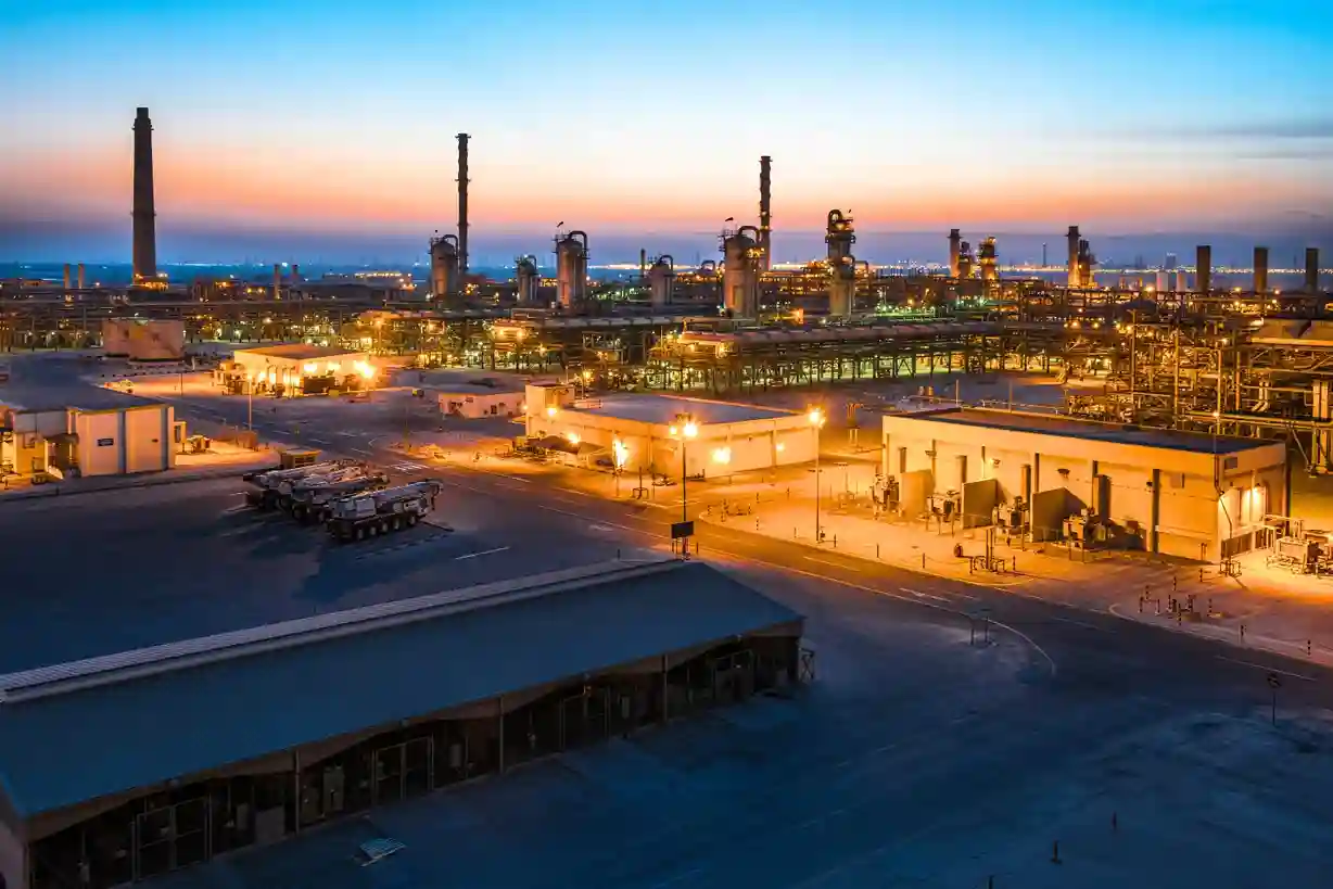
A major pillar of this multi-tier infrastructure strategy is Jafurah’s Phase 4 expansion project.
This specific upstream phase represents a SAR 5.63 billion development contract awarded to Larsen & Toubro Energy Hydrocarbon to build vital gas processing facilities in the remote southern sector of the reserve.
However, setting up heavy industrial assets within remote desert basins introduces immediate civil engineering hurdles.
Before engineering teams can pour concrete foundations or clear heavy staging equipment, they must deploy advanced pre-construction site assessment workflows.
Achieving this level of spatial data accuracy requires abandoning slow manual ground treks and utilizing airborne laser scanning to master the rugged desert topography.
Quantifying the Underlying Asset Value: Jafurah Resource Geodynamics
The massive scale of this pre-construction grading work is directly tied to the vast volume of energy resources trapped beneath the basin floor. The sheer density of these underground reserves justifies the strict requirement for sub-centimeter geographic precision during initial site leveling.
- The Total Gas Accumulation: The target shale formation is estimated to contain a massive resource base of 229 trillion standard cubic feet of raw gas. This makes it the largest liquid-rich shale gas play in the Middle East.
- The Liquid Condensate Volumetrics: Alongside the dry gas, the reserve holds an estimated 75 billion stock-tank barrels of liquid condensate. This highly valuable byproduct requires specialized chemical processing systems at the plant sites, demanding zero tolerance for structural foundation shifts.
- The Century-Scale Capital Lifecycle: Because of the vast geographic area of the field, Aramco projects that the total multi-phase investment over the lifecycle of the development will exceed SAR 375 billion across all phases.
Because these heavy compression assets are built to operate continuously for decades, a foundational failure caused by poor soil assessment or unmapped underground erosion paths could jeopardize a multi-billion-dollar energy hub.
This long operational timeframe makes a precise pre-construction terrain survey vital to ensure long-term structural safety.
Jafurah Phase 4 Engineering Scope
The foundational step of the active development cycle begins with field mobilization for the upstream extraction assets.
Civil engineering contractors must transform irregular, shifting sand formations into highly stable, structurally sound industrial foundations capable of supporting thousands of tons of vibrating mechanical hardware.
Jafurah Phase 4 Civil Design Metrics
| Total Contract Valuation | SAR 5.63 billion |
| Planned Gas Processing Capacity | 200 Million cf/d per Plant |
| Total Plants to Be Constructed | 2 Base Compression Facilities |
| Single Plant Footprint Dimensions | 400 x 400 Meters |
| Total Pad Surface Area Per Plant | 160,000 Square Meters |
The scale of this specific construction stage introduces major civil engineering demands:
- The Financial and Operational Risk: The initial infrastructure phase relies on a contract valued at approximately SAR 5.63 billion awarded to Larsen & Toubro Energy Hydrocarbon. With capital deployment of this magnitude, any delay in early-stage site preparation directly causes compounding financial penalties.
- The Plant Processing Densities: Contractors are actively breaking ground to establish two massive gas compression plants. Each facility is designed to process up to 200 million cubic feet a day (cf/d) of raw gas extracted from the surrounding fields.
- The Massive Grading Challenge: To house the gas separation units, compression trains, and chemical injection systems safely, each individual plant requires an absolute construction footprint measuring exactly 400 by 400 meters in the remote southern reserve field.
A single 400-by-400-meter footprint translates into 160,000 square meters of continuous desert land that must be graded completely flat.
In a rugged desert environment, sand dunes and bedrock ridges vary in height significantly.
If an engineer encounters an unmapped 5-meter elevation variance across a 400-meter span, the earthmoving crews must move tens of thousands of cubic meters of additional soil just to level one pad.
Without highly accurate topographic maps before machinery arrives, calculating these earthwork requirements is prone to severe estimation errors.
The Cross-Country Midstream Network: Master Gas System Phase 3 Logistics
Once raw gas is extracted and stabilized at the compression plants, it cannot remain localized within the basin.
It must be pressurized and transported across vast distances to reach terminal stations, industrial cities, and regional power networks.
This requires linking the extraction plants to a massive cross-country pipeline network.
To manage this country-wide logistical load, the midstream infrastructure must scale up proportionally:
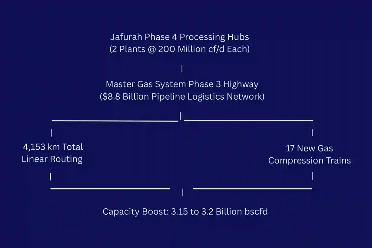
- The Dedicated Midstream Capital: Out of a broader series of strategic natural gas contract awards totaling SAR 93.8 billion across the entire energy portfolio, a major budget of over SAR 30 billion is strictly allocated to execute Phase 3 of the Master Gas System (MGS) expansion.
- The Massive Linear Mapping Footprint: Construction crews must map, trench, and install approximately 4,153 kilometers of new high-pressure steel pipelines. This expansive grid spans the East-West logistics corridor, running through jagged mountain gaps, deep valleys, and shifting sand plains.
- The Pressure Management Infrastructure: To keep the massive volume of gas flowing across thousands of kilometers without pressure drops, the network requires the construction of 17 new gas compression trains and stations.
- The Project Work Package Segregation: To optimize supply chains and manage multiple regional contractors simultaneously, the cross-country pipeline construction is managed through 17 distinct engineering work packages.
- The Total Grid Throughput Capacity: The ultimate milestone for this midstream development is to deliver a net capacity boost of 3.15 billion to 3.2 billion standard cubic feet per day (bscfd) by 2028.
The engineering reality of laying 4,153 kilometers of heavy steel pipe requires managing complex terrain challenges. The pipeline path must cross rugged hills, avoid natural flash-flood paths, and maintain an optimal slope gradient to prevent internal moisture accumulation.
If a routing team relies on low-resolution satellite imagery or slow ground-based mapping teams to choose the line’s path, they risk running into unmapped rock formations or unstable sand cliffs. These unexpected terrain obstacles can stall multi-million dollar welding crews and disrupt the entire construction schedule.
Utilizing highly dense, pre-construction airborne data is the only reliable way to keep these massive infrastructure projects moving on time and within budget.
Deploying Active Drone LiDAR for Topographic Mapping
Resolving the Photogrammetric Blind Spot in Arid Landscapes
Traditional aerial surveying often relies on photogrammetry, a method that uses high-resolution cameras to stitch together hundreds of overlapping visual photographs. While photogrammetry is highly effective in urban zones or areas with distinct visual markers, it encounters a severe technical barrier when deployed across large desert basins. The sand dunes across the expansion zone frequently feature uniform, repeating color textures and low visual contrast.
When mapping software attempts to match pixels from overlapping images of identical-looking sand faces, the alignment algorithms often fail. This matching error results in warped digital models, artificial elevation gaps, and inaccurate terrain files.
Furthermore, photogrammetry cannot pierce through airborne dust, wind haze, or the sparse, stubborn desert scrub vegetation that populates the desert floor. Deploying active Light Detection and Ranging (LiDAR) completely bypasses these visual limitations.
Unlike passive cameras that depend on ambient sunlight and surface contrast, a LiDAR sensor serves as an active remote sensing system. The payload generates its own light source, emitting hundreds of thousands of concentrated laser pulses per second toward the earth’s surface.
The sensor then measures the exact time it takes for each laser beam to hit the ground and bounce back to the receiver. Because it calculates distance based on the absolute speed of light and precise time-of-flight physics, it does not require surface contrast or optimal lighting conditions to deliver sub-centimeter geographic coordinates.
Ground-Based Mapping via FJD Trion V10i RTK GNSS System
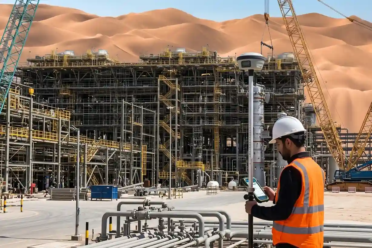
To establish an absolute geodetic foundation across the changing terrain of the Jafurah basin, field surveying teams deploy the FJ Dynamics FJD Trion V10i RTK GNSS System for high-precision ground measurements.
This system provides the baseline coordinate control required to verify high-accuracy field grids.
- Multi-Constellation Satellite Tracking: The receiver features 1408 channels and supports full constellation tracking across GPS, GLONASS, Galileo, BeiDou, QZSS, and SBAS signals. This expansive signal access ensures rapid signal initialization in under 5 seconds and reliable satellite coverage under harsh desert sky conditions.
- Visual Positioning and AR Stakeout: The hardware integrates an innovative dual-camera design, using a 2 MP front-facing camera and a 5 MP downward-facing global shutter camera. Field engineers utilize the AR Stakeout function for real-time, on-screen video guidance to locate design points instantly. For hazardous, steep, or physically inaccessible dune locations, the Visual Measure function utilizes multi-engine algorithms to capture centimeter-level coordinates safely from a distance of up to 15 meters.
- Calibration-Free IMU Tilt Surveying: To maximize measurement speed over irregular landscapes, the V10i utilizes inertial measurement unit (IMU) tilt compensation up to 60 degrees. Surveyors can capture highly accurate points continuously without wasting time leveling or holding the survey pole perfectly vertical.
- Technical Accuracy and Rugged Build: The device delivers standard RTK positioning accuracy of 8 mm + 1 ppm horizontally and 15 mm + 1 ppm vertically. Housed in a lightweight alloy body resistant to magnetic interference, its IP68-rated, 2-meter drop-proof design guarantees continuous operation in intense windblown dust and heat.
Drone Mapping: The DJI Matrice 400 and Zenmuse L3
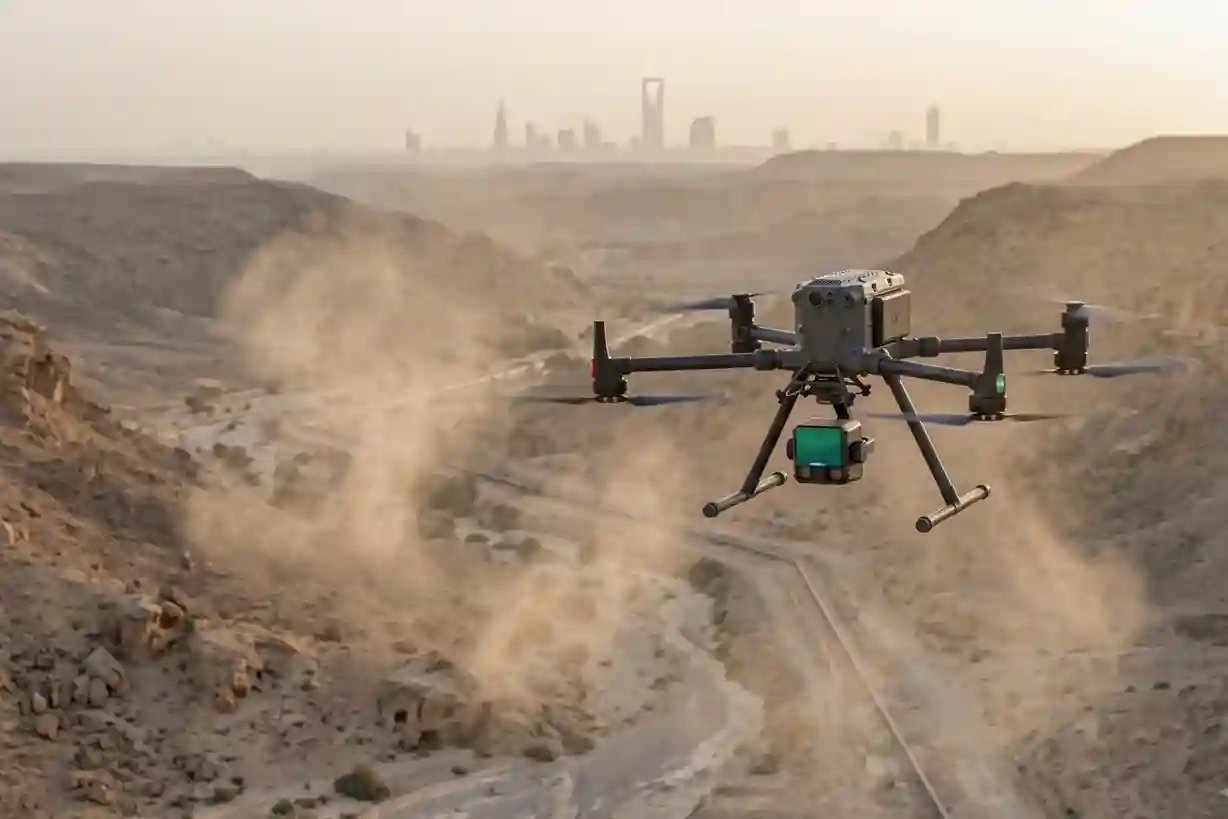
To execute this high-density data capture smoothly across expansive project coordinates, field teams deploy an integrated hardware configuration consisting of the DJI Matrice 400 and the Zenmuse L3 payload.
This system is purpose-built to operate reliably within the harsh operational constraints of remote desert flight paths.
DJI Matrice 400 & Zenmuse L3 Operational Profile
| Sensor Positioning Framework | Real-Time Kinematic (RTK) GNSS |
| Target Point Cloud Density | 100 to 150 Points Per Square Meter |
| Maximum Laser Return Capacity | Up to 5 Discrete Echoes Per Pulse |
| Flight Tracking Method | Automated Terrain-Follow Mode |
During a typical pre-construction mission, the workflow prioritizes several critical technical settings:
- Real-Time Kinematic (RTK) Precision: The DJI Matrice 400 utilizes a top-mounted RTK GNSS receiver that communicates constantly with a localized ground base station. This real-time link ensures that every single laser pulse fired by the sensor is stamped with an absolute geographic coordinate, eliminating the centimeter-level positioning drift common in standard satellite navigation.
- Automated Terrain-Follow Flights: Shifting desert topographies feature sudden elevation changes that can distort data consistency if a drone flies at a fixed barometric altitude. DJI Matrice 400 uses real-time radar sensors to adjust its flight height automatically, keeping a constant distance above the changing desert floor. This maintains uniform laser footprint sizing and consistent point density across the entire survey plot.
- Advanced Multi-Return Extraction: The Zenmuse L3 utilizes multi-return laser technologies capable of recording up to five discrete echoes from a single laser pulse. When a laser beam encounters a localized dust cloud or a patch of desert scrub, the sensor records the initial reflection as the top of the obstruction. The remaining energy continues downward, reflecting off the true, solid earth below. This capability allows processing software to strip away vegetation and dust layers completely, leaving only raw, bare-earth elevation values.
Data Processing Pipeline: From Point Clouds to VDC Integration
The raw output collected by the drone during its flight path consists of a massive, unclassified point cloud, a digital cluster containing millions of independent XYZ coordinate points.
Transforming this raw data into an actionable engineering file requires a structured data processing pipeline within specialized Virtual Design and Construction (VDC) software.
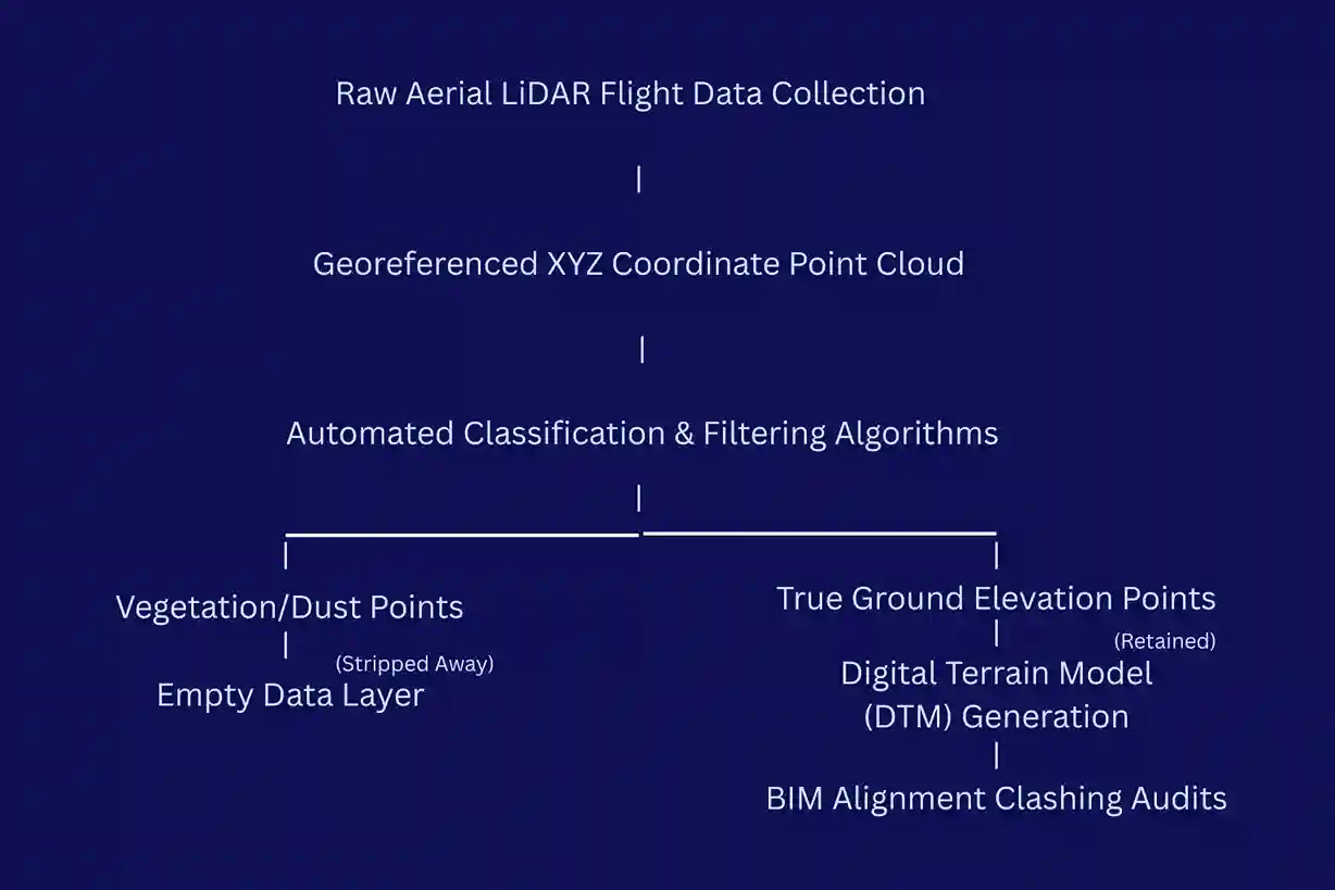
First, the georeferenced point cloud undergoes automated classification filtering. The algorithms analyze the spatial relationships between neighboring points to identify and isolate anomalies. Points generated by surface vehicles, temporary drilling rigs, dust clouds, and desert bushes are separated into independent data layers.
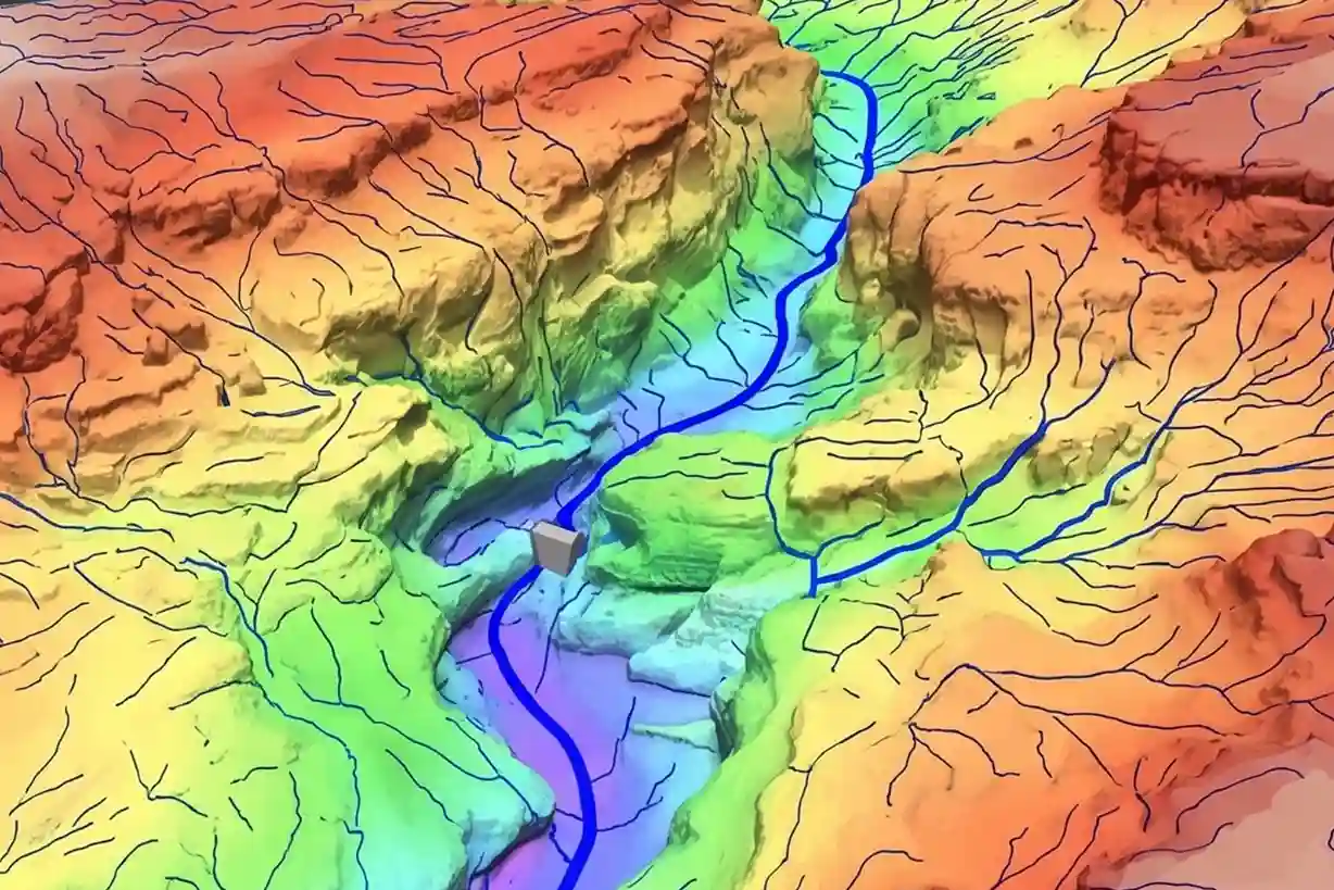
Once these non-ground elements are stripped away, the software uses the remaining bare-earth points to generate a highly detailed Digital Terrain Model (DTM). This DTM acts as an absolute topographic foundation mesh. Engineers import this precise 3D landscape model directly into Building Information Modeling (BIM) platforms to plan the layout of the two 400-by-400-meter gas compression facilities.
By overlaying the structural blueprints directly onto the real-world terrain model, designers can run automated clashing audits. This workflow allows project managers to spot potential construction errors, such as an intake line designed to pass through an unmapped rock ledge. Long before teams begin active field excavations.
Quantitative Hydrological Analysis and Wadi Channel Modeling
One of the most valuable benefits of high-density drone LiDAR mapping is its ability to protect heavy infrastructure assets from unpredictable desert weather hazards.
Arid landscapes look dry and stable, but their sun-baked, compacted soils act almost like concrete during sudden cloudbursts, preventing water infiltration and generating massive volumes of high-velocity surface runoff.
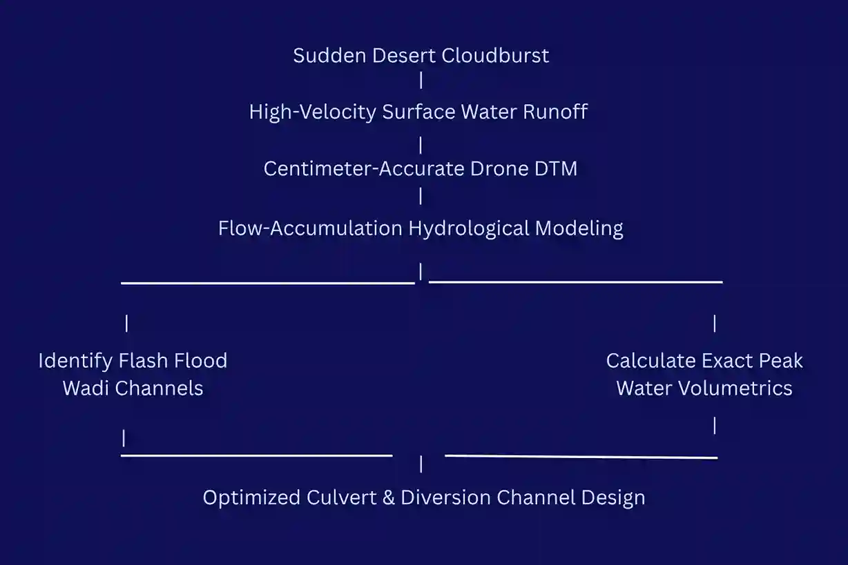
Using the centimeter-accurate elevation grids provided by the drone survey, civil engineers can execute advanced hydrological flow simulations:
- Mapping Flash Flood Wadi Channels: The DTM highlights the exact pathways of natural wadi channels. The dry desert riverbeds instantly transform into raging rivers during unexpected rainstorms.
- Calculating Runoff Volumetrics: By analyzing the surrounding slope changes and catchment sizes, engineers can calculate the exact velocity and peak volume of water that will drain toward the industrial site during 50-year and 100-year storm events.
- Designing Targeted Diversion Infrastructure: Rather than guessing where to build drainage networks, designers use the drone data to position concrete diversion channels, protection berms, and structural culverts exactly where the water naturally moves.
This proactive data integration ensures that the extensive gas pipeline corridors and billions of dollars in gas infrastructure investments remain fully secure against severe flash-flood undermining throughout their multi-decade operational lifecycles.
Simplify Your Pre-Construction
Relying on traditional ground surveys or low-resolution charts for large-scale utility developments risks costly earthwork miscalculations, drainage hazards, and construction delays.
Integrating automated drone LiDAR into your early engineering pipeline provides clear, centimeter-accurate terrain models.
This data allows your team to verify facility foundations and optimize pipeline routes before heavy machinery ever arrives on-site.
Contact our expert to automate your topographic mapping that protects your downstream budgets and secure your next infrastructure project.

