Drones alone are no longer enough for operational purposes. While a high-performance aircraft is the “muscle” of the operation, it is merely a vehicle for sensors. To truly unlock value, reliable software is needed to process large amounts of data acquired during field missions.
The complexity of modern infrastructure means that “one size fits all” no longer exists; the software must be compatible with your specific needs, whether that requires the agility of the cloud, the “fortress” security of an on-premises server, real-time awareness, or intelligent automation. Understanding this shift, DJI is equipping its equipment with a reliable, integrated software ecosystem designed to bridge the gap between a flight and a finished report.
The Management Pillar: Command, Control, and Sovereignty
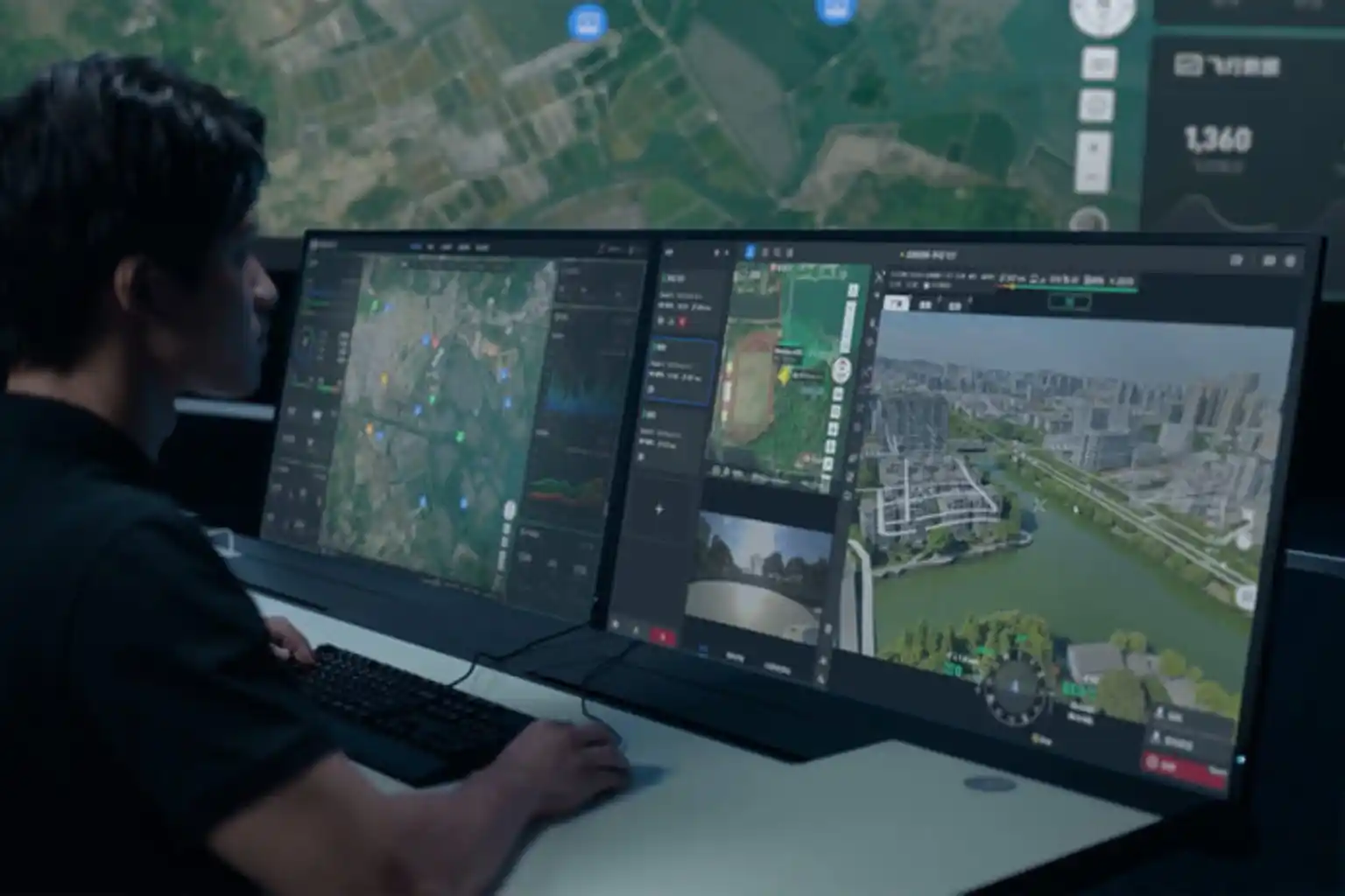
In the professional drone landscape of 2026, management is no longer just about tracking flight paths; it is about exercising absolute authority over data and real-time operations. DJI’s management pillar is defined by two distinct architectures that cater to different organizational security requirements: FlightHub 2 (Public Cloud) for agile, multi-site coordination, and FlightHub 2 On-Premises for missions requiring an “air-gapped” fortress of data sovereignty.
1. The AIO (All-in-One) Hardware
The DJI FlightHub 2 AIO is the cornerstone of localized drone management. It is a 3.01 kg portable server specifically engineered to run the full On-Premises software stack without an internet connection.
- Edge Computing Power: The unit is powered by an Intel® Core™ Ultra 7 Processor 265 and 64 GB of DDR5 RAM, allowing it to handle up to 20 simultaneous devices (drones and docks) with a peak resource utilization of approximately 80%.
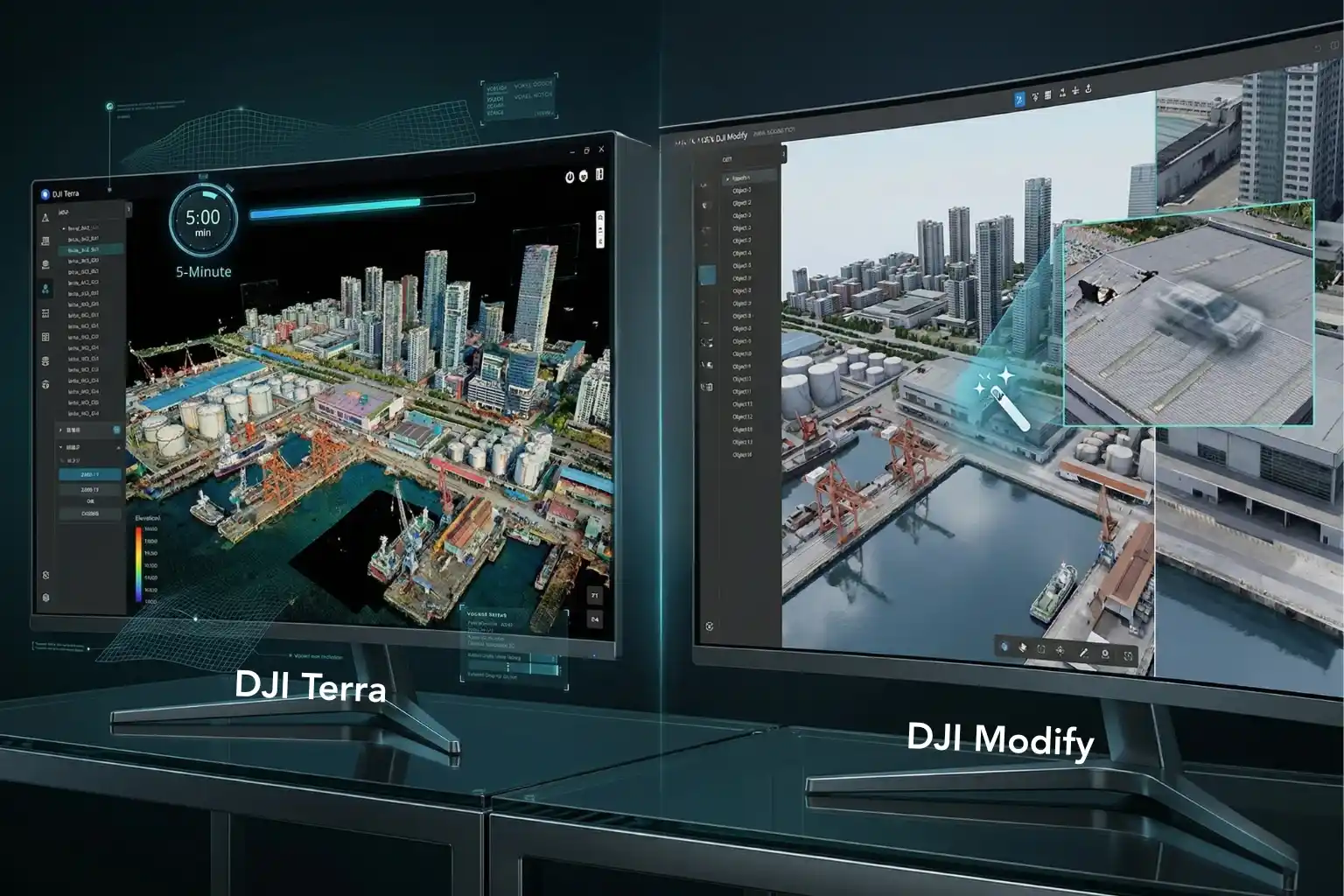
- GPU-Accelerated Intelligence: An integrated NVIDIA RTX™ 2000 Ada graphics card drives the localized DJI Terra modeling engine, enabling the AIO to process $500$ drone images into a detailed 3D model in just five minutes.
- Data Redundancy: Storage is secured by three 2 TB NVMe SSDs. While one is reserved for the system, the other two operate in a RAID 1 mirrored configuration, ensuring that a hardware drive failure does not result in the loss of critical mission data.
2. Technical Command: Virtual Cockpit and Automation
The software architecture transitions drone operation from a field-level task to a centralized command center experience.
- Virtual Cockpit: This interface allows remote operators to pilot drones using a mouse and keyboard. Features like FlyTo automation calculate safe, efficient routes with a single click, while intelligent object tracking uses on-device AI to detect and monitor vehicles or vessels automatically.
- Independent Frontend Components: FlightHub 2 On-Premises is modular, offering three independent frontend components, such as Flight Routes Editor, Virtual Cockpit, and Project/Map. These can be integrated directly into an organization’s existing software stack, significantly reducing the development workload for custom platforms.
3. Sovereignty and System Integration
Sovereignty is achieved through total isolation of the drone’s data cycle from the public internet.
- Air-Gapped Deployment: Organizations can deploy the platform on physical machines within a Local Area Network (LAN) or private cloud servers, ensuring that photos, videos, telemetry, and flight logs never leave the internal firewall.
- MQTT Bridge and OpenAPI: To support high-level industrial integration, the system includes an MQTT Bridge for bridging and forwarding messages to SCADA or other enterprise systems. The RESTful OpenAPI allows developers to call core platform capabilities directly, enabling seamless integration with existing IT workflows.
- Secure Authentication: The platform supports OAuth 2.0 and Single Sign-On (SSO), allowing for unified authentication and granular user permission management within a corporate identity system.
4. Connectivity Reliability
For missions in signal-deprived or restricted areas, the management pillar utilizes hardened communication links.
- 4G Enhanced Transmission: When combined with a DJI Cellular Dongle 2 and a dedicated private 4G APN card, the system maintains high-definition video transmission and coordination even when the standard SDR signal is obstructed by terrain or structures.
Manual Mastery and Mission Automation
In the field, the software is the primary interface between the human operator and the aircraft’s hardware. DJI’s “Field Pillar” is divided between DJI Pilot 2 (the DJI Enterprise app), which excels at high-stakes manual mastery, and DJI GS Pro, designed for rigorous mission automation.
1. DJI Pilot 2: Real-Time Tactical Awareness
DJI Pilot 2 is the default flight control application for modern enterprise drones, serving as the pilot’s cockpit for situational awareness.
- Augmented Reality (AR) Overlay: Pilot 2 utilizes AR projection to display Home Points, PinPoints, and mission Waypoints directly within the camera view. This allows the pilot to maintain high situational awareness without constantly switching to a map view.
- Advanced Payload Control: It provides deep integration for hybrid sensors, including Link Zoom, which allows for simultaneous zooming with both thermal and visual sensors. Pilots can also activate Discrete Mode for sensitive night operations, turning off all aircraft lights with a single tap.
- Tactical AI Features: The app supports Smart Track, which uses on-device AI to automatically follow moving subjects like vehicles or vessels, significantly reducing the pilot’s cognitive load during complex missions.
- Pre-Flight Integrity: Every mission begins with a comprehensive pre-flight checklist that integrates aircraft status, sensor health, and localized environmental parameters to ensure a safe takeoff.
2. DJI GS Pro: Professional Mission Architecture
While Pilot 2 is built for the pilot, DJI GS Pro (Ground Station Pro) is built for the mission architect. This iPad-based application is specialized for repeatable, automated workflows that require millimeter precision.
- Complex Waypoint Missions: GS Pro supports up to 99 waypoints per mission group. Each waypoint can be programmed with up to 15 consecutive actions, such as precise gimbal pitching, aircraft rotation, and timed photo capture, ensuring every data point is captured exactly as planned.
- 3D Map POI (Circle and Vertical): Specialized modes allow for high-fidelity data collection of tall structures. Circle Mode automates a spiral flight path around a building, while Vertical Mode executes precise “up-and-down” paths to gather data for vertical reconstructions, such as bridge pylons or skyscrapers.
- GIS Data Integration: Operators can import KML, SHP, KMZ, and ZIP files directly into GS Pro. This allows construction and survey teams to overlay project boundaries or specific geometries onto the map to generate flight paths that correspond exactly to site blueprints.
- The Virtual Fence: For site safety, GS Pro features a Virtual Fence that defines a strict 3D flight boundary. If the aircraft approaches these custom boundaries, it will automatically brake and hover, preventing unauthorized entry into restricted zones or proximity to hazardous infrastructure.
3. The Comparison: Tactical Response vs. Structural Planning
| Feature | DJI Pilot 2 (Enterprise) | DJI GS Pro |
| Primary Use | Search and Rescue, Patrol, Inspection | Surveying, AEC, Precision Ag |
| Control Style | Active, Real-time, AR-enhanced | Programmed, Automated, Repeated |
| Payload Focus | Live Thermal/Zoom switching, Laser Range Finder | High-precision photogrammetry and mapping |
| Platform | Integrated Controller (RC Plus/RC Pro) | iPad OS |
Unify Your Drone Intelligence Strategy
Choosing the right software isn’t just a technical decision, it’s a strategic one to secure and scale your fleet. By integrating the full DJI ecosystem, you reduce the friction of using third-party tools and ensure that your data is handled with the same precision as the flight itself.
To complete your comprehensive editorial on the DJI Enterprise Software Ecosystem, here are four visual suggestions designed to guide the reader through the journey from field data acquisition to secure, professional intelligence.