In the heavy industrial landscape, the most critical assets, such as storage tanks, massive boilers, underground mine shafts, and ship cargo holds are often the most dangerous to inspect. Traditional manual methods require scaffolding, specialized high-risk permits, and placing human lives in dark, dusty, and oxygen-depleted environments. The Terra Xross 1, developed by Terra Drone Corporation in Japan, eliminates these risks by making challenging indoor environments accessible, simple, and safe for every worksite.
Navigational Supremacy in GPS-Denied Zones
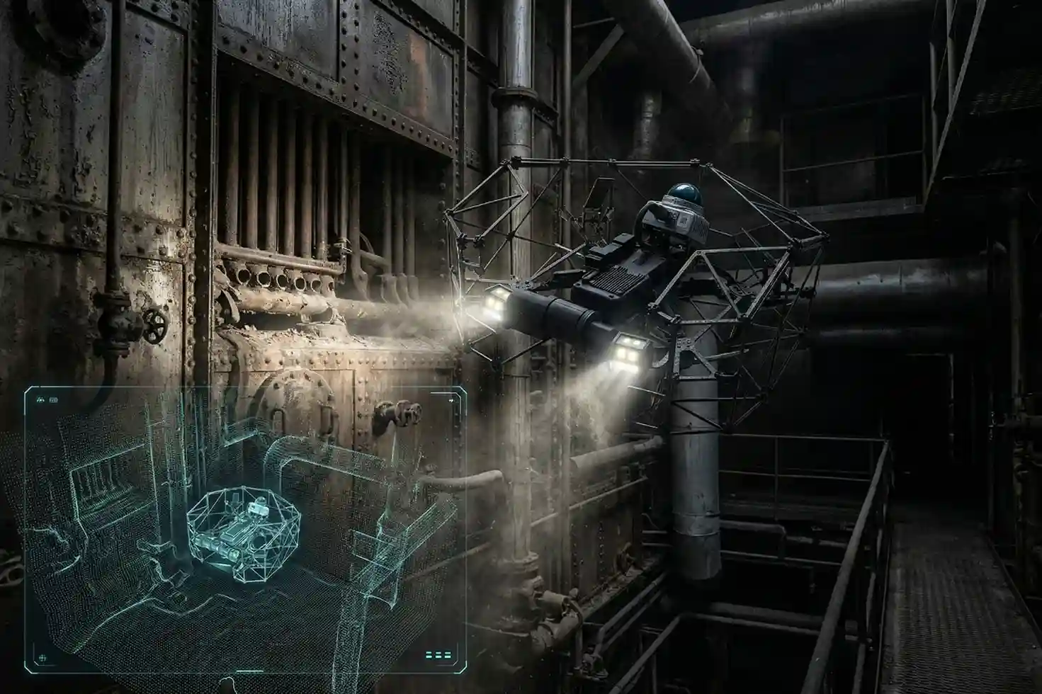
The Terra Xross 1 is specifically engineered to thrive where standard drones fail. By integrating advanced LiDAR-based navigation, the system overcomes the obstacles of indoor dust and total darkness.
- Stable Flight without GPS: LiDAR sensors ensure steady hovering and precision flight, making operation straightforward even in confined, complex geometries.
- Visual Odometry: Coupled with LiDAR, visual sensors allow the drone to maintain its position in GPS-denied environments with high reliability.
- Real-Time 3D Mapping: During Beyond Visual Line of Sight (BVLOS) operations, the drone provides a real-time 3D data view. This grants operators total situational awareness, ensuring safe navigation around internal obstacles without direct line of sight.
Precision Imaging and Persistent Operation
Industrial maintenance requires high-fidelity data to identify microscopic cracks, corrosion, or structural anomalies. The Terra Xross 1 delivers this intelligence through a robust sensory and power stack:
- 4K 180° Tilt Camera: The integrated camera provides high-resolution 4K footage, while the 180-degree tilt capability allows for thorough obstacle verification and close-up structural analysis of ceilings and tight corners.
- Integrated LED Lighting: High-intensity LED illumination ensures that even the darkest chimneys or tanks are rendered with professional-grade clarity.
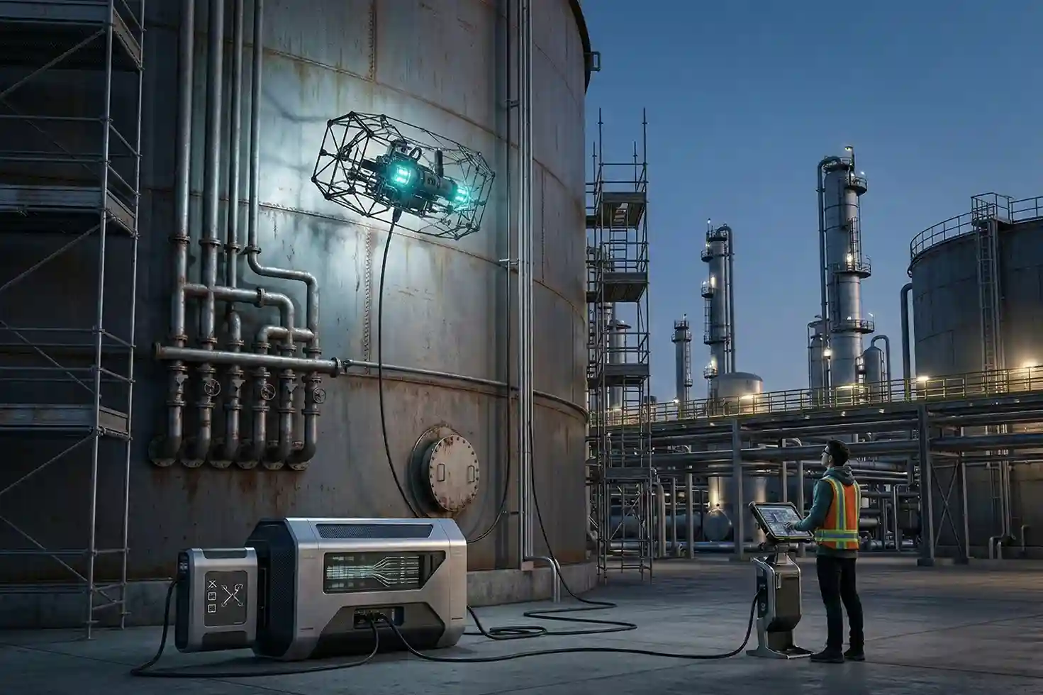
- The Tether Advantage: While standard batteries provide 10 minutes of agile flight, the optional Tether System allows for continuous power. This removes the risk of battery exhaustion, enabling exhaustive mapping and multi-hour inspections of massive assets without the need for frequent swaps.
- Spatiotemporal Cloud Intelligence: Through the Terra Xross Cloud, captured images and videos are automatically associated with 3D point cloud data. This allows maintenance teams to manage data intuitively and share actionable insights with stakeholders worldwide in real-time.
Make Innovation Your New Norm
From the refineries of the Eastern Region to the shipping ports of the Red Sea, the Terra Xross 1 is transforming how Saudi Arabia maintains its industrial integrity. By offering a platform that balances simplicity with hardcore industrial performance, Terra Drone Arabia is helping companies reduce downtime and prioritize worker safety.
Experience the future of industrial maintenance. Contact us today for a FREE demo and see how the Terra Xross 1 can elevate your confined space inspection capabilities to the next level.