Drones for Aerial Surveillance: How They Save 95% of Your Cost

Drones for aerial surveillance are rapidly overtaking traditional manned platforms, offering organizations a transformative blend of cost efficiency, rapid deployment, and operational flexibility. Whereas helicopter-based surveys can rack up $650 per flight hour, modern drones operate at $20 per mission hour, slashing expenses by 95%. This shift isn’t just financial in sectors from emergency response to infrastructure inspection. It fundamentally changes what teams can achieve in the field. Cost Breakdown: Helicopters vs. Drones for Aerial Surveillance When every dollar counts, understanding the true cost of observation is vital: Helicopter Ops: Typical emergency or survey missions require fuel, crew, maintenance, and insurance, adding up to $650. Drones for Aerial Surveillance: Comprehensive mission costs, including pilot time, batteries, and routine upkeep, average $20/hr. That’s a 95% reduction. Consequently, a 10-hour survey that costs $6,500 by helicopter falls to just $200 with drones, freeing budget for additional sorties or advanced sensor payloads. Operational Advantages Beyond Price Beyond pure cost savings, drones for aerial surveillance bring strategic benefits: Rapid Deployment & Scalability Helicopters require flight plans, landing zones, and specialized clearances. Drones launch within minutes from virtually any safe area, and fleets can scale linearly, doubling coverage by adding more UAVs. Lower Logistical Overhead Ground support, maintenance crews, and refueling operations tie up resources for manned aircraft. Drones use standard power outlets for battery charging; maintenance is modular and often software-driven. Enhanced Safety & Accessibility Human crews face hazards in low-altitude, confined, or polluted airspaces. Drones navigate tight corridors—under bridges, inside industrial plants, or above dense canopies—without endangering personnel. Real-World Use Case During Hajj season 1446H, Terra Drone Arabia partnered with NUPCO and the Saudi Ministry of Health to overcome critical logistics challenges in Mina and Arafat, where traditional ground transport often took over 1.5 hours. Leveraging DJI M350 RTK drones fitted with temperature-controlled transport boxes, we achieved sub-6-minute medical deliveries across sprawling, pedestrianized zones. Pre-Mission Integration Flights were planned within Unifly’s UTM system, enabling real-time deconfliction, dynamic rerouting, and automated landing instructions, ensuring safe operations in crowded airspace. Regulatory clearance was secured via the Ministries of Health, Interior, Defense, and GACA, establishing approved corridors over holy sites. Rapid Deployment & Transit Each sortie began with a 60-second pre-flight health check (battery, sensors, comms). Drones ascended to 100 m AGL, traversed direct routes over rooftops and open areas, and bypassed all ground congestion, cutting what was once a 1.5-hour journey down to 6 minutes. Secure Medical Logistics Specialized payload compartments maintained strict temperature control for blood products and samples, with continuous telemetry monitoring. Live HD video and encrypted telemetry fed to a central command hub, where medical teams tracked ETA and prepared for real-time handoff. Scalable & Redundant Operations At peak, a six-drone fleet operated in rotating shifts. Should any unit lose link, backup drones automatically assume the mission. Integrated LiDAR, mmWave radar, and geo-fencing ensured zero airspace incursions or incidents. This Hajj initiative not only demonstrated a 95% reduction in delivery time but also showcased a blueprint for urban drone logistics under complex crowd and regulatory conditions, validating drones as a core component of rapid emergency response and disaster management. Ready to transform your aerial intelligence? Contact us for your tailored drone surveillance assessment.
Drone Workforce Development: Building the Future Ahead

The rise of drone workforce development is reshaping modern industries worldwide. From oil and gas fields to construction zones and energy grids, drones have become indispensable tools for inspection, monitoring, and asset management. In an era defined by digital transformation and Industry 4.0, the demand for drone technologies is accelerating faster than ever. However, technology alone isn’t enough. As industries embrace unmanned aerial solutions, the need for a skilled, certified drone workforce is becoming critical, especially in countries like Saudi Arabia, where national goals like Vision 2030 prioritize innovation, localization, and the development of future-ready industries. The Role of Drones in Critical Industrial Applications The integration of drones into industrial operations is no longer a futuristic concept — it is a present-day necessity. Industries across the globe are rapidly adopting drone technology to enhance safety, boost operational efficiency, and gather higher-quality data than ever before. Drones are fundamentally changing the way critical infrastructure is built, maintained, and managed, offering companies a smarter, faster, and safer alternative to traditional methods. In today’s industrial landscape, drones fulfill several pivotal roles: aerial data capture, real-time monitoring, digital modeling, hazard detection, and predictive maintenance support. Their ability to deliver detailed information quickly, often without interrupting operations, is helping industries achieve more with fewer risks and lower costs. Let’s take a deeper look at how drones are making a difference across key industrial sectors: Oil & Gas Few sectors benefit from drones as much as oil and gas, where safety concerns, expansive assets, and harsh operating environments demand innovative solutions. Applications include: Flare Stack Inspections Traditionally, inspecting an active flare stack required a full shutdown, resulting in significant production losses. Now, drones equipped with thermal cameras can perform these inspections while the stack remains live, identifying heat anomalies, corrosion, and structural defects in real time. Pipeline Surveillance Long stretches of pipelines that traverse remote or sensitive areas can be monitored efficiently with drones. UAVs can detect leaks, ground movement, unauthorized encroachments, or potential erosion issues early, preventing environmental disasters and costly repairs. Offshore Platform Monitoring Drones equipped with high-resolution imaging and LiDAR sensors provide detailed views of complex offshore structures without risking diver safety or costly helicopter flyovers. The result: enhanced worker safety, reduced downtime, and improved asset reliability. Construction & Infrastructure Drones have become essential tools at every stage of construction and infrastructure projects. Applications include: Progress Monitoring UAVs deliver frequent, accurate site surveys, helping project managers track construction progress, verify contractor work, and identify potential delays early. Digital Twins Drones gather the precise spatial data needed to create detailed 3D digital twins of infrastructure assets — bridges, tunnels, airports, etc. These virtual replicas support smarter maintenance planning, remote inspections, and lifecycle management. Inspection of Existing Structures Bridges, high-rise buildings, and critical public infrastructure are inspected faster and more thoroughly using drones, minimizing disruption to traffic and operations. With drone-driven site intelligence, developers and engineers can make better decisions, mitigate risks, and deliver projects more efficiently. Power & Utilities Maintaining a safe, reliable power grid depends heavily on proactive inspection and maintenance, areas where drones excel. Applications include: Transmission Line Inspection UAVs fly alongside live high-voltage power lines, capturing detailed images and thermal data to detect faults, hotspots, and wear without the need for human linemen to climb towers. Substation Monitoring Thermal drones quickly spot overheating components or insulation breakdowns in substations, preventing costly outages and safety hazards. Vegetation Management LiDAR-equipped drones identify vegetation encroaching on power lines, enabling utilities to optimize their trimming and clearing efforts to reduce wildfire risks and service interruptions. By adopting drone technology, utilities gain higher-frequency inspections, greater visibility across their networks, and better-informed maintenance strategies. Environmental & Agricultural Monitoring Drones are playing a vital role in advancing environmental stewardship and smart agriculture practices. Applications include: Crop Health Monitoring Multispectral imaging drones analyze plant health, soil moisture levels, and pest infestation patterns across agricultural fields, empowering farmers to make data-driven decisions that boost yields and reduce chemical usage. Land and Forest Management Drones map forest boundaries, monitor illegal logging activity, and assess biodiversity health in remote regions. Disaster Response and Environmental Impact Assessments After floods, oil spills, or wildfires, drones provide immediate situational awareness, enabling faster environmental impact assessments and targeted remediation efforts. Air and Water Quality Monitoring Specialized UAVs are equipped to capture air samples or perform water sampling missions to measure pollutants, supporting regulatory compliance and sustainability initiatives. By making environmental monitoring more accessible, faster, and cost-effective, drones are helping industries meet ESG (Environmental, Social, and Governance) targets and regulatory requirements. Why Drones are Indispensable in Industrial Applications Across all these sectors, the same core advantages of drones shine through: Risk Reduction Keep workers out of dangerous environments — drones handle the height, the depth, and the hazards. Cost Efficiency Reduce operational expenses by eliminating the need for scaffolding, helicopters, shutdowns, or large field teams. Data Quality Capture more comprehensive, high-resolution, and multi-dimensional datasets than traditional methods ever could. Operational Continuity Perform inspections, surveys, and monitoring tasks without halting production or disrupting critical services. In essence, drones are not just supplementary tools — they are now integral components of industrial asset management strategies worldwide. Current Challenges in Drone Workforce Development Despite surging demand, industries still face significant challenges in building a robust drone workforce: Talent Shortage While drone technology has advanced rapidly, the pipeline of qualified, industry-ready drone professionals has lagged behind. Many sectors report a shortage of certified UAV pilots and data analysts with practical, sector-specific expertise. Lack of Certified Drone Professionals Certification matters. Regulatory bodies increasingly require formal licensing (such as GACAR Part 107 in Saudi Arabia, or FAA Part 107 in the U.S.). Yet many aspiring drone operators lack access to structured, accredited training that meets industry standards. Limited Specialized Training in Industrial Applications Operating a recreational drone is very different from performing a LiDAR survey of a gas pipeline or conducting thermal inspections of electrical grids. Training programs must evolve to focus on industrial-specific applications — not just general drone operation.
How Drones in Hazardous Areas Collect Data Safely and Efficiently

Transforming Data Collection: Drones in Hazardous Areas Drones in hazardous areas deployment for data collection has been a game-changer in various industries. Their ability to traverse dangerous environments and deliver real-time, accurate data is revolutionizing operations, while ensuring a higher degree of safety for personnel. Benefits of Using Drones in Hazardous Areas for Data Collection Drones provide an invaluable advantage in hazardous areas. They mitigate risks by reducing human exposure to danger, and their advanced sensor technology allows for comprehensive data collection that can significantly improve decision-making and efficiency in various operational processes Also Read: Revolutionizing Inspections: The Role of Drones for NDT in Oil & Gas and Petrochemical Industries Data Collection Drones: How Do They Work? Equipped with a myriad of sensors and high-resolution cameras, drones can effectively map hazardous areas, monitor environmental conditions, and capture visual data for inspections. The information collected can be processed and analyzed to provide insights and drive more effective strategic decision-making. Read More: Confined Space Drones: Reducing Hazardous Exposure Real-World Applications: Drones Collecting Data in Hazardous Areas Whether it’s mapping radiation levels in a nuclear power plant or collecting data in a chemical factory, drones are an instrumental tool. Their flexibility and versatility make them apt for a variety of applications, significantly transforming traditional methods of data collection in hazardous areas. The Future of Drones in Hazardous Area Data Collection The potential of drones extends far into the future, with advancements in technology such as AI and machine learning promising to augment their capabilities further. Enhanced data analysis, real-time tracking, and predictive maintenance are just a few areas where these advancements could lead. Read More: NOAA launches first of its kind drone in Hurricane Ian to research areas unsafe for Hurricane Hunters Impact of Drones in Hazardous Area Data Collection In conclusion, UAVs in hazardous areas for data collection are setting new standards in safety and operational efficiency. Their versatile applications and the valuable data they provide are driving significant transformation in industries known for their risk-prone environments.
How Drone for Solar PV Helps Plant Construction

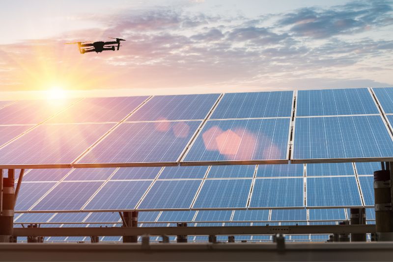
Empowering Solar PV Construction: The Role of Drones The use of a drone for solar PV plant construction is rapidly becoming an industry standard. Drones bring a range of benefits to the construction process, enhancing efficiency, safety, and decision-making. Let’s explore how drones are changing the game in solar PV plant construction. Site Analysis and Project Planning Drones equipped with advanced imaging technology provide comprehensive and accurate site analysis. This data is crucial for optimal project planning, ensuring the efficient use of resources and shortening the construction timeline. Also Read: Sky-high Solutions: 5 Benefits of Using Drones in Petrochemicals Industry Real-time Construction Monitoring Drones offer an unmatched ability for real-time monitoring of the construction process. This allows for immediate detection of any issues or deviations from the plan, enabling quick corrective actions. Also See: 7 Valuable Uses For Drones in the Solar Industry Enhancing Safety and Reducing Risks The use of drones significantly reduces the need for workers to access potentially dangerous areas, enhancing overall site safety. Additionally, drones can detect safety hazards, contributing to a safer construction environment. Read More: Airborne Vigilance: Using Drone for Safety Violation Detection in Plants Quality Assurance and Inspection Post-construction, drones can be used for detailed inspections of the solar PV installation. They can spot defects or issues that may not be visible from the ground, ensuring quality assurance. See More: Autonomous Drones to Monitor 250-Acre Floating Solar Farm Future of Drones in Solar PV Construction As drone technology continues to advance, its role in solar PV plant construction is set to grow. With features like AI and machine learning, drones can automate and enhance many aspects of the construction process, contributing to faster, safer, and more efficient solar PV plant construction. In conclusion, drones have proven to be a powerful tool in solar PV plant construction. They streamline the construction process, enhance safety, and improve decision-making, making them an indispensable asset in the industry’s progression.
Best Drone For Your Company’s Operations

Navigating the Sky of Choices: How to Choose the Best Drone Selecting the best unmanned aircraft for your company’s operations can be a complex task given the multitude of choices available. Each drone offers unique capabilities and suitability for different operational contexts. Here’s a guide on how to choose the best UAVs for your business needs. Consider the Nature of Your Operations The first step in selecting the best UAV is to thoroughly understand your operational requirements. Whether you need a drone for surveying large areas, performing detailed inspections, or collecting specific data, the nature of your operations should guide your drone choice. Also Read: Safety from the Sky: Using Drone for Confined Space Inspections Evaluate Drone Specifications and Capabilities Each drone model comes with a set of specifications and capabilities. Payload capacity, flight time, range, camera resolution, sensor types, and resistance to weather conditions are among the key factors to consider. Also See: Five industries benefiting from drone inspections Assess Compliance with Regulatory Requirements Ensure that your chosen drone complies with local and international drone regulations. This includes flight restrictions, licensing requirements, and safety and privacy regulations. Read More: Flying into the Future: The Role of Drones in Digital Transformation Look into Cost-effectiveness Beyond the purchase price, consider the overall cost-effectiveness of the drone. This includes maintenance costs, the lifespan of the drone, and the potential savings it can bring to your operations. See More: Drone market outlook in 2023: industry growth trends, market stats and forecast Future-proof Your Investment Lastly, consider how future-proof the drone is. As drone technology continues to evolve rapidly, choosing a drone that can be upgraded or that is adaptable to future technological developments can be a wise investment. In conclusion, choosing the best UAV for your company’s operations involves careful consideration of various factors. By taking the time to understand your needs, assess drone capabilities, and consider regulatory and cost factors, you can select a drone that significantly enhances your operational efficiency and effectiveness.
Integrating Drone Technology: Starting a Drone in Oil & Gas Company’s In-house Program

Drone in Oil & Gas Promise Drones are making a significant impact across various sectors, and the oil & gas industry is no exception. The advent of a drone in an oil & gas company’s in-house program symbolizes a major leap forward, promising increased operational efficiency, improved safety measures, and enhanced data accuracy. Why Deploy Drones in Oil & Gas Company’s Operations? These unmanned aerial vehicles (UAVs) are transforming the oil & gas landscape. An in-house drone program allows these companies to perform real-time monitoring, routine inspections, and precise data collection. The use of drones in oil & gas operations decreases the need for manual labor, mitigating safety risks and enhancing operational efficiency. In addition, drones also provide cost-effective solutions, making them a valuable addition to any energy company’s technological arsenal. Read more: Revolutionizing Pipeline Inspections: Drone Applications in the Oil & Gas Industry Implementing UAVs Program in Oil & Gas: Key Steps and Considerations Initiating a UAV or drone program involves a comprehensive understanding of regulatory guidelines, dedicated training for staff, and investments in robust equipment. Familiarity with the FAA guidelines for commercial UAV usage is a crucial first step. Moreover, the program should emphasize risk management, maintenance schedules, and data privacy considerations, ensuring seamless and secure UAV operations in oil & gas companies. Read more: FAA Guideline for Drone Commercial Operator The Future of UAV Technology in Oil & Gas Industry With the technological advances, drones are poised to become an indispensable tool in the oil & gas industry. The integration of drones promises a future of improved automation and heightened operational efficiency. By investing in a drone in-house program today, oil and gas companies could gain a significant competitive advantage in the future. In conclusion, the integration of a drone in-house program in an oil company can revolutionize operations, offering numerous benefits that enhance overall productivity and safety. It’s a worthwhile investment, considering the promising future of drone in oil & gas industry. Read more: Drones Deliver Impressive Results