The Challenge Beneath the Surface
The foundations of the MENA economy—jetties, bridges, seawalls, port facilities, and offshore energy platforms—rely on submerged infrastructure. These assets face a brutal, unseen enemy: the marine environment. Constant exposure to seawater, which is highly corrosive, leads to material loss. This structural decay is worsened by biofouling—the rapid growth of marine organisms that attach to surfaces and accelerate corrosion.
These environmental stressors lead to structural fatigue and threaten the longevity of vital infrastructure. The traditional approach to inspection only compounds the problem:
- Safety, Risk, and Accessibility: Inspecting submerged assets typically requires human divers. This process is inherently risky due to high currents, low visibility, and deep or confined spaces. Human divers are physically limited in depth and endurance, restricting their bottom time to one or two hours.
- High Cost and Downtime: Diver-based inspections are costly and time-consuming, requiring extensive coordination and specialized teams. For assets like fuel tanks, inspection often requires draining the tank, halting operations, and causing significant revenue loss.
- Data Quality: Diver reports are often subjective, lack precise location data (geotagging), and are difficult for engineers to rely on for long-term predictive models.
The region urgently needs a safer, more efficient, and data-driven way to manage its critical maritime assets.
The Rise of ROV-Based Monitoring
Remotely Operated Vehicles (ROVs) are robotic systems that are transforming underwater inspection workflows by eliminating the need for human presence in high-risk zones. This technology has moved from specialized offshore use to become the standard for routine ROV-based monitoring for marine inspection assets.
I. Advanced Technologies for Unseen Environments
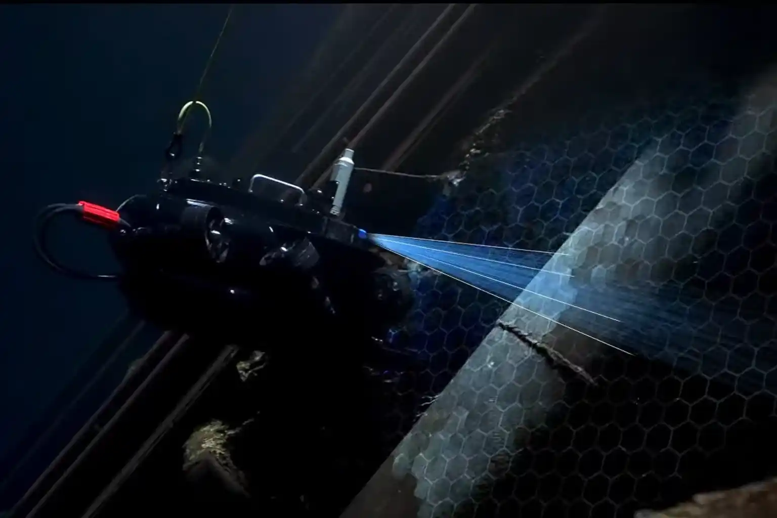
Inspection-class ROVs are compact, agile, and equipped with a versatile sensor suite designed to overcome the limitations of the marine environment.
- Visual and Sonar Imaging: ROVs use high-definition cameras and bright LED lighting to provide unparalleled visibility in clear water. More critically, they carry multibeam or scanning sonar for navigation and imaging in areas with poor visibility, such as murky water or sediment-rich areas. Sonar emits sound waves to create a clear picture of the environment, even when the operator cannot see.
- Navigation and Positioning: Advanced systems leverage DVL (Doppler Velocity Log) and U-INS (Underwater Inertial Navigation System) to ensure stable control and precise positioning. This means the ROV can hover automatically in turbulent conditions and record the exact GPS coordinates of every finding (geotagging), allowing for easier data correlation later.
- Core Payloads: ROVs are modular and can carry essential tools, including laser scaling devices for precise measurement, environmental sensors (temperature, salinity), and Ultrasonic Thickness (UT) gauges for Non-Destructive Testing (NDT).
II. Applications Across Marine Infrastructure
ROV-based monitoring for marine inspection assets is suitable for virtually all submerged structures:
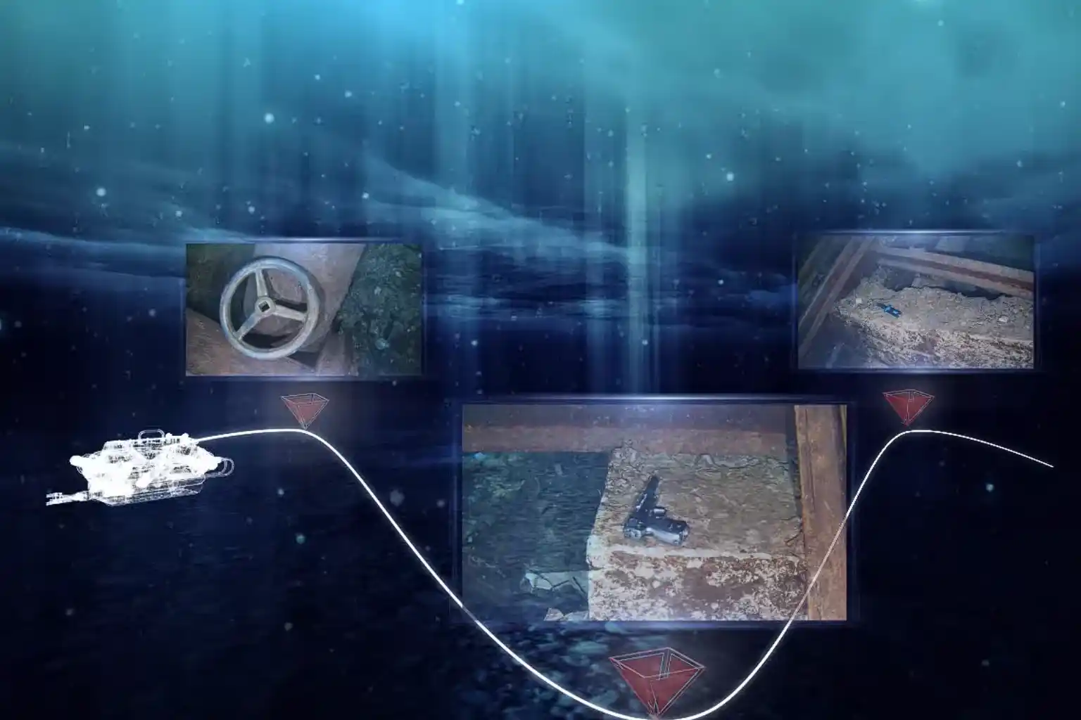
- Port Facilities and Jetties: ROVs inspect submerged concrete degradation, scour (erosion around foundations), joint separations, and piling integrity.
- Offshore Energy: They assess corrosion, marine growth, and cathodic protection anodes around platform jackets, risers, and offshore wind turbine foundations.
- Vessels and Confined Spaces: Shipowners use ROVs for underwater hull inspection and ballast tank checks, often eliminating the need for costly dry docking.
- Pipelines and Cables: ROVs perform routine checks for corrosion, sediment buildup, structural anomalies, and accurate depth-of-burial surveys.
From Reactive to Predictive Maintenance
The immediate deployment and continuous operation of ROVs transform asset care from a reactive, emergency response into a proactive, data-driven strategy.
III. Enabling Proactive Asset Management
- Reduced Human Risk and Downtime: The primary gain is safety. ROVs operate in challenging conditions such as extreme depths, high currents, and contaminated waters, eliminating risks to human divers. Furthermore, ROVs can be deployed in minutes and operate continuously without the time restrictions of human divers, ensuring operational continuity.
- Quantitative Corrosion and Damage Assessment: Equipped with UT gauges, ROVs perform precise NDT, measuring wall thickness to determine corrosion and material loss. The data collected is highly traceable and auditable.
- Continuous Monitoring for Early Detection: The low cost and rapid deployment encourage more frequent inspections. This continuous monitoring allows owners to detect minor anomalies early, preventing small cracks or corrosion spots from escalating into severe structural failures.
- digital twin Integration: The high-resolution video, sonar images, and UT measurements are stored in cloud platforms like Terra 3D Inspect. This data builds and updates the asset’s digital twin, a virtual replica that allows managers to run simulations, forecast structural decay, and schedule maintenance precisely, maximizing the asset’s lifespan.
IV. Synergy with Full Asset Visibility
The underwater data is far more valuable when combined with aerial and terrestrial data. Our workflow integrates ROV bathymetry and scour data with drone LiDAR surveys of the dry dock and pier structures above the water line. This holistic approach provides complete, 360° asset visibility, moving beyond the subsea environment alone.
Advancing Coastal Resilience with Smart Inspection
The integration of remote technology is no longer optional; it is essential for supporting sustainable coastal and offshore infrastructure development under Saudi Vision 2030.
- Adoption Mandate: Organizations must adopt ROV-based monitoring for marine inspection assets as a cornerstone of their asset integrity programs. The cost benefits, avoiding drainage, reducing labor, and preventing downtime far exceed the cost of the technology itself, often providing a payback period of less than one year.
- Standardization and Integration: We encourage the integration of ROV data into existing GIS and digital twin systems for seamless lifecycle tracking.
- Partnering for Expertise: Terra Drone Arabia offers a complete suite of solutions, combining specialized expertise in subsea data acquisition with world-leading technology. We partner with innovators like QYSEA Technology to utilize ROVs (like the FIFISH Expert series) that are compact, maneuverable, and equipped with AI-enabled navigation and sonar systems. Our certified team ensures safe, efficient deployment and delivers actionable insights.
Secure the long-term integrity of your marine assets. Contact us to discuss implementing an ROV pilot program and transforming your maintenance strategy from reactive to predictive.