In 2026, the margin for error in industrial surveying has effectively vanished. As we move toward a world of autonomous site governance and high-fidelity digital twins, the 1–2 centimeter accuracy range has transitioned from a specialized requirement to the baseline standard for every project.
However, achieving this level of precision is rarely a “plug-and-play” affair. Urban canyons with skyscraper-induced signal multipath, dense foliage that chokes satellite visibility, and dangerous, unreachable points like deep trenches or high-traffic intersections have historically degraded GNSS performance. The FJD Trion V10i breaks these barriers. By fusing 1408-channel satellite tracking with a high-speed IMU and dual-camera visual positioning, it maintains a centimeter-level “Fix” where traditional receivers find only frustration.
The Technical Pillars of V10i Accuracy
To achieve millimetric precision, the V10i relies on a multi-engine architecture that cross-references satellite data, inertial movement, and visual geometry in real-time.
1. 1408-Channel Multi-Constellation Tracking
At the heart of the V10i is a massive 1408-channel GNSS board. While older receivers might track a dozen satellites, the V10i maintains a locked connection with every major global constellation simultaneously: GPS, GLONASS, Galileo, BeiDou, QZSS, and IRNSS.
- Fast Fix Initialization: This dense satellite coverage allows for a “Cold Start” fix in under 5 seconds, ensuring your team is productive the moment they step onto the site.
- Interference Mitigation: Utilizing advanced signal processing often powered by the Septentrio Mosaic-X5 chipset. The V10i filters out atmospheric noise and electronic interference, maintaining a stable horizontal accuracy of 8mm + 1ppm.
2. Calibration-Free IMU Tilt Compensation
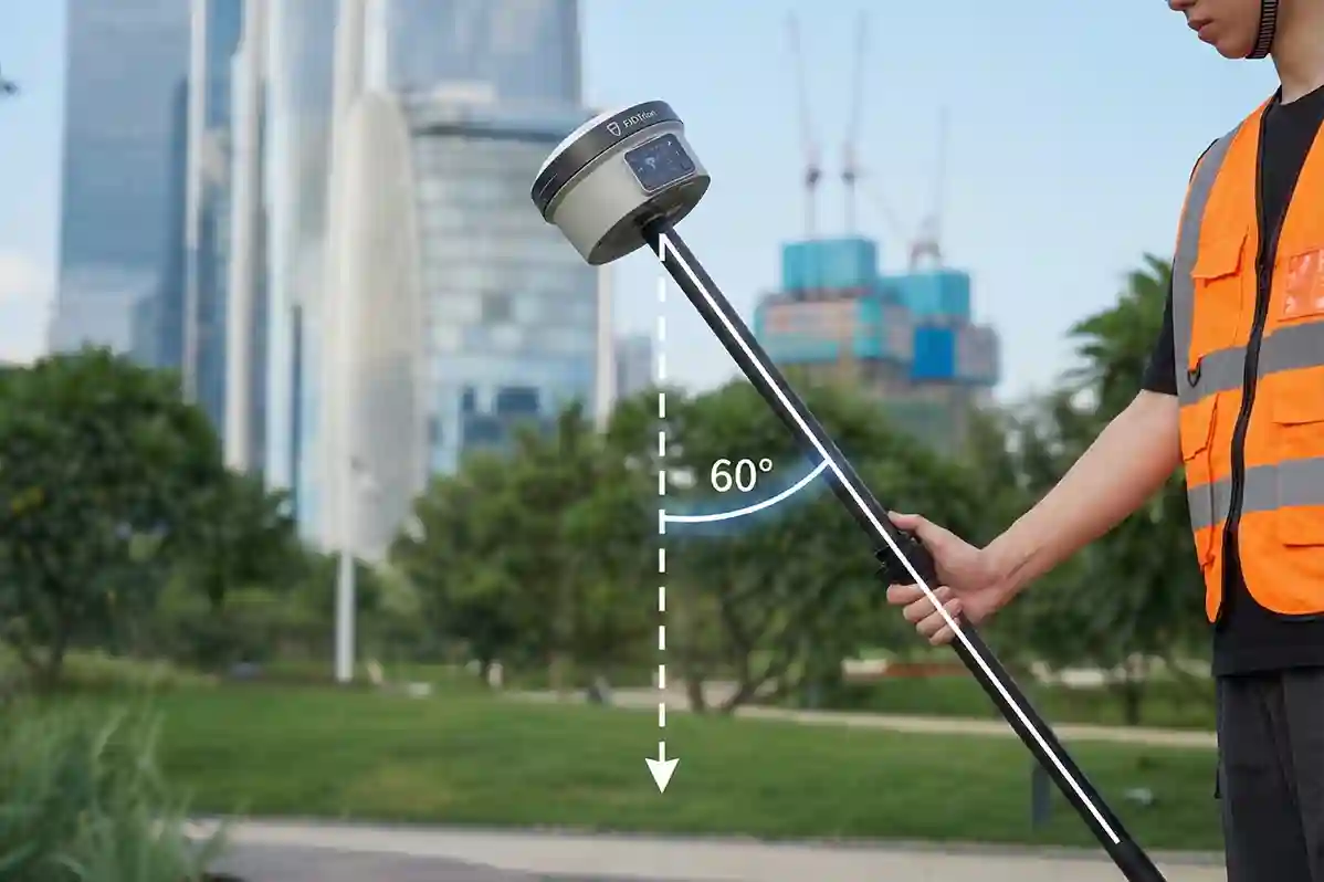
The physics of the V10i allows for a “tilt and go” workflow. Traditional surveying requires the pole to be perfectly vertical (leveling the bubble), which is slow and prone to human error.
- The 60° Advantage: The V10i’s integration compensates for pole angles up to 60° while maintaining a positioning accuracy of 3 cm.
- No Manual Leveling: This allows surveyors to measure the corners of buildings, utility foundations, or the bottom of slopes without needing to stand directly over the point or maintain a perfect vertical.
3. Visual Measure: The Eye of Precision
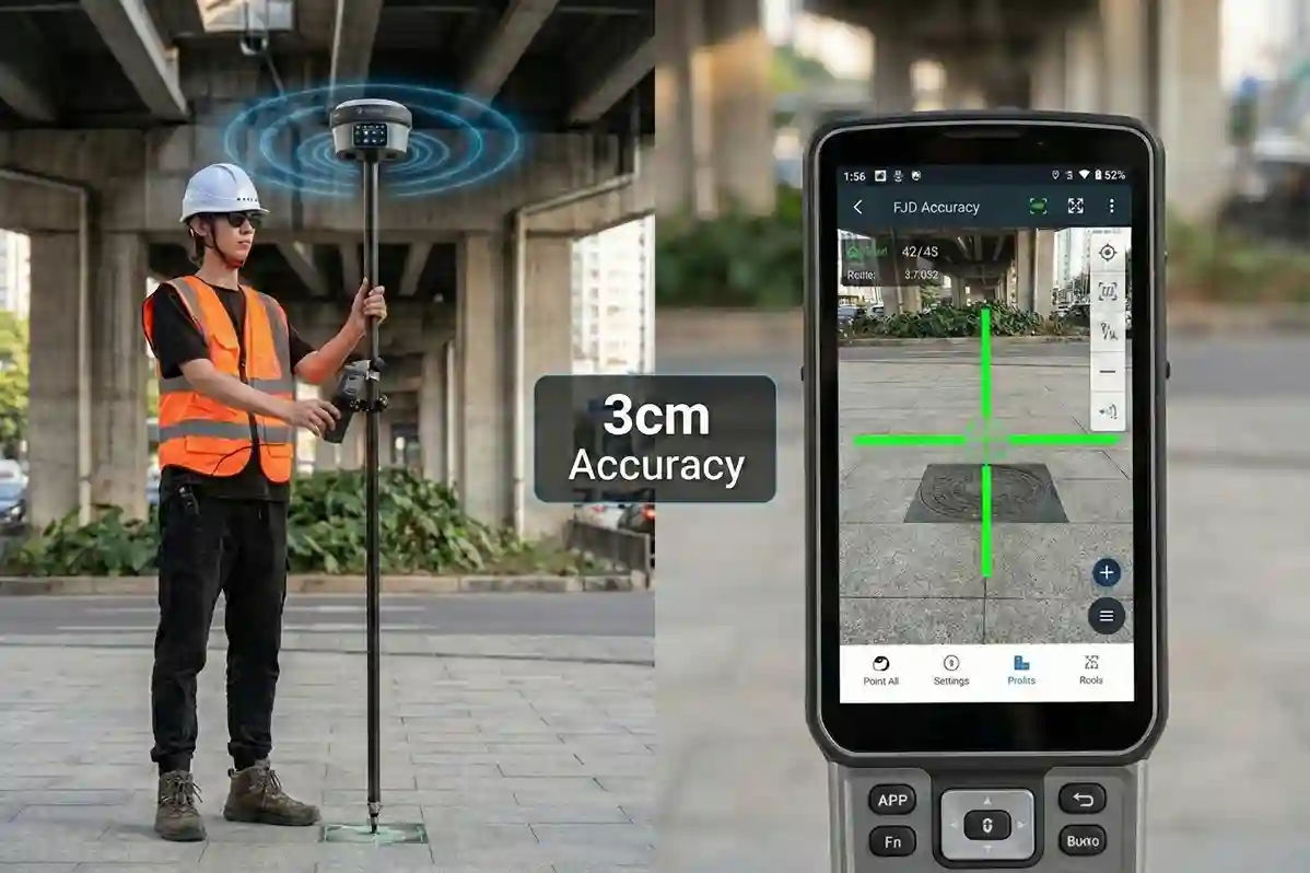
The most distinct technical leap of the V10i is its dual-camera system.
- Dual Global Shutter Cameras: Featuring a 2MP and 5MP camera array, the V10i performs Visual Surveying. By clicking a photo on the controller, the system uses “Vision-Inertial-GNSS” fusion to triangulate coordinates.
- 3–5 cm Remote Accuracy: This allows for the capture of points that are physically unreachable or dangerous, such as a manhole in the middle of a highway or a point across a river with survey-grade precision from up to several meters away.
Optimizing the Workflow for Maximum Precision
Centimeter accuracy is not just about the hardware; it is about the “Digital Handshake” between the field and the office.
AR Stakeout: Efficiency Reimagined
Traditional staking involves “hunting” for a point by following directional arrows. The V10i’s AR (Augmented Reality) stakeout overlays the target point directly onto the live video feed of your controller. This visual guidance allows operators to reach the exact coordinate up to 5X faster than traditional methods, with millimetric precision upon arrival.
Site Setup and Correction Links
To maintain that 8mm horizontal accuracy, the V10i provides flexible correction options:
- Internal UHF Radio: For remote sites (5–8 km range) where cellular signals are non-existent.
- Network RTK (NTRIP): For urban agility, connecting via 4G to existing base station networks for instant corrections.
Data Integrity through the Trion Cloud
Every coordinate logged is instantly synced to the trion survey cloud. This ensures that your high-precision data is backed up and available for immediate engineering review, preventing the “data silos” that often lead to project rework.
Deploying the Precision Revolution
The FJD Trion V10i is more than a receiver; it is a gateway to the autonomous site. By combining visual intelligence with 1408-channel reliability, it allows your team to perform at a level of speed and accuracy that was previously impossible.
Architect your autonomous future. Contact us today to audit your site requirements and show you, wherever you are, how the FJD Trion RTK ecosystem will bridge your precision and labor gap for 2026.