The Pilotless Revolution
The future of urban transportation is not just in the air; it is autonomous. To realize the full potential of Advanced Air Mobility (AAM), air taxis must transition from human-piloted craft to fully autonomous systems capable of scaling across busy metropolitan centers. However, this transition faces a massive technical hurdle: the “urban canyon” effect.
In dense cities like Riyadh or Dubai, traditional GPS-based navigation systems often fail because tall buildings block or reflect signals, leading to high positioning uncertainty. For a pilotless air taxi, a loss of GPS signal is more than an inconvenience. It is a critical safety risk. To solve this, the industry is engineering a hybrid intelligence layer that combines high-resolution digital twins with synthetic vision. These technologies act as the essential “eyes” of autonomous air taxi navigation, allowing vehicles to move with millimeter precision regardless of satellite availability or visibility conditions.
How Autonomous Systems “See”
Pilotless flight requires two distinct types of “vision”: a pre-loaded knowledge of the world (the map) and a real-time ability to navigate within it (the sensor).
I. High-Resolution Photogrammetry: The “Reference Map”
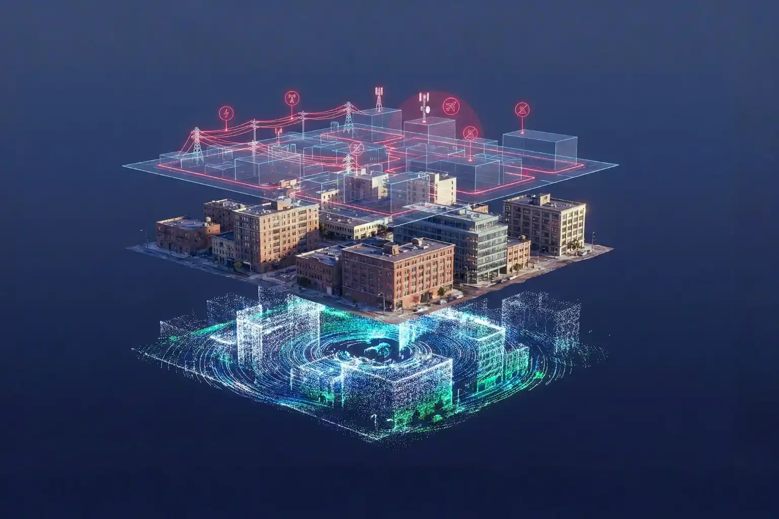
Before an air taxi even takes off, it needs a perfect 3D digital replica of its environment, a digital twin.
- Data Capture: Using specialized mapping drones, we capture thousands of overlapping high-resolution images of the urban landscape.
- 3D Reconstruction: Through photogrammetry, these 2D images are processed offline into highly accurate 3D textured mesh models.
- The Result: This provides the air taxi with a “geometric anchor,” a static world model that includes every building edge, helipad, and power line with centimeter-level accuracy.
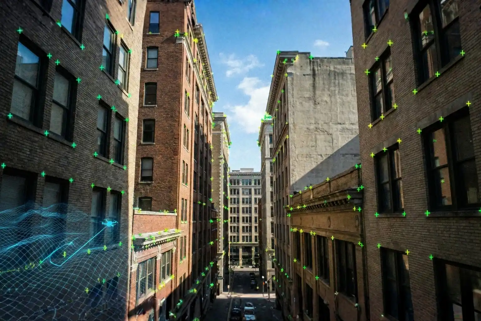
II. Visual SLAM: The “Real-Time Eye”
While photogrammetry provides the map, Visual Simultaneous Localization and Mapping (Visual SLAM) provides the movement.
- GPS-Denied Precision: Onboard cameras extract distinctive “visual words” or features from the surrounding environment in real-time.
- Dynamic Mapping: As the taxi flies, it iteratively builds a sparse 3D point cloud of its path, comparing it instantly to its pre-loaded Digital Twin to correct for trajectory drift.
- Continuous Tracking: This allows the vehicle to determine its position and attitude (orientation) at the speed of acquisition, ensuring it stays on its designated path even without GPS.
III. Synthetic vision Systems (SVS): The Virtual Cockpit
synthetic vision is the technology that fuses the map and the sensor data into a 3D virtual representation of the external world.
- Intuitive Navigation: SVS takes terrain, obstacle, and traffic data and renders it as computer-generated imagery.
- Weather Independence: Because SVS relies on on-board databases and real-time sensor fusion rather than human eyesight, it remains fully functional in zero-visibility conditions like heavy fog, smoke, or total darkness.
Building Trust in Autonomy
For autonomous air taxi navigation to become the norm, it must prove it is safer than a human pilot. Trust is built through three layers of digital protection:
- Predictive Safety via digital twins: Operational digital twins (ODTs) allow for synthetic testing of unmanned traffic management. The system can simulate thousands of emergency scenarios like sudden engine failure or unexpected obstacles to refine how the autonomous autopilot will respond in the real world.
- 360-Degree Situational Awareness: While a human pilot has limited forward visibility, a synthetic vision system processes 360-degree data from visual, thermal, and LiDAR sensors simultaneously. This ensures the aircraft can detect and avoid other drones or birds long before they enter its immediate flight path.
- Reliability Through Sensor Fusion: The aircraft does not rely on a single data source. It tightly integrates Inertial Measurement Units (IMU), Visual SLAM, and healthy GPS signals (when available) to maintain stable flight even during extreme wind or equipment malfunctions.
Operationalizing the Sky
The pilotless revolution is no longer a distant dream, it is an engineering reality. The combination of photogrammetry-based digital twins and visual SLAM navigation is the cornerstone of safe, scalable autonomous air taxi navigation.
The time to digitize is now, the sky-highways of 2030 are being mapped today. Without high-resolution digital infrastructure, the “eyes” of tomorrow’s air taxis will have nothing to see.
Create the high-resolution digital twins required for autonomous navigation, ensuring your urban assets are ready for the first wave of commercial eVTOL flights.