Quadruped Ground Robot with Zero Human Risk For Hazardous Industrial Inspections.
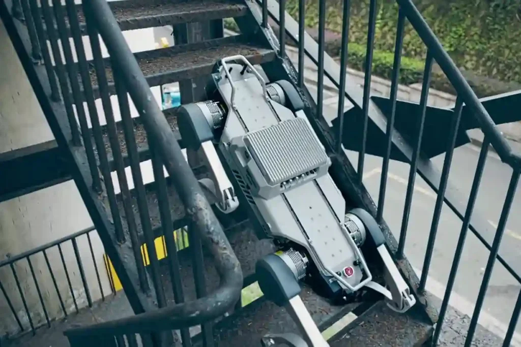
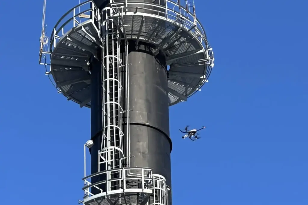
The Unsolved Risk in Industrial Ground Inspection Industrial facilities, power plants, pipeline corridors, deep tunnels, and vast construction sites demand continuous oversight. This oversight traditionally falls to human patrol inspectors. These workers face constant, severe hazards: exposure to toxic gases, extreme heat, high voltage, complex obstacles, and unstable terrain. This manual ground patrol method creates two major problems: High Risk: It constantly puts personnel in harm’s way, leading to potential injuries and high operational safety costs. Low Efficiency: Patrols are repetitive, slow, and often yield subjective data. The need for constant human supervision reduces efficiency and increases labor costs. Modern industry requires a solution that is tireless, fearless, and precise. The necessary transformation is intelligent, unmanned inspection using specialized ground robots. This powerful shift to ground robotics for inspection eliminates human exposure while ensuring that critical assets are monitored $24/7$. Core Technical Capabilities and Industrial Application The solution to the ground risk problem is the agile autonomy and rugged design of the Deep Robotics X30 quadruped robot. This machine is built specifically to operate where humans cannot, turning hazardous patrol routes into repeatable, digital missions. I. Core Technical Advantage: All-Terrain Autonomy The X30 platform’s mechanical and digital architecture guarantees performance and reliability in the MENA region’s challenging industrial environments. A. All-Weather, All-Terrains Coverage The X30’s physical design overcomes almost any obstacle. Extreme Protection: The robot boasts industrial protection above IP66, making it waterproof and dustproof. This allows it to operate continuously for 24 hours in severe operating environments such as heavy rain, snow, or hail. Superior Mobility: It achieves superior mobility by easily navigating obstacles and unstructured surfaces. It can climb stairs up to a 45° slope, stably climb hollow industrial stairs, and move freely through complex environments like ruins, gravel, stone mills, and rough grasslands. This capability minimizes disturbance to the scene and reduces the chance of secondary accidents. Adaptation: The robot exhibits strong adaptation capability, achieving rapid deployment for high-precision data acquisition, analysis, and danger warning. B. Smart Digital Transformation and Control The X30 is fundamentally a digital asset, designed to integrate seamlessly into a centralized control environment. Closed-Loop Workflow: The navigation system handles complex business processes. The Smart Controller simultaneously processes navigation and business-related programs, primarily providing map construction and location navigation. This system enables a closed-loop workflow: High-precision auto-navigation, auto-charge, automatic data capture, and real-time data upload to the superior site. Risk Detection: The entire process connects to the centralized control system. Real-time data syncs immediately, allowing the system to detect potential defects in time to prevent incidents, ensuring the safe operation of equipment. II. Application Deep Dive: Power & Utilities (P&U) and Tunnels The X30 directly supports the transformation of routine asset monitoring within critical infrastructure. A. Autonomous Inspection Workflow for P&U The X30 facilitates efficient, digital, intelligent inspection with a simple autonomous workflow: Path Planning: Operators explore targets and set up the inspection path and mission. Execution: The robot performs real-time inspection based on pre-set navigation paths. Reporting and Charge: It generates real-time results and reports, and then returns for auto-charge, preparing for the next inspection cycle. Advanced Sensing: The robot uses a Bi-spectrum Camera (infrared/visible light) for intelligent recognition and defect alarm analysis. It also features an Acoustic Imager to achieve precise sound source positioning, helping to accurately distinguish and quickly troubleshoot different types of partial discharge (like corona or floating discharge). Remote Action: Equipped with an Agile Robotic Arm, the X30 can execute remote tasks such as grabbing, switching doors, or picking up items, enabling unmanned operation and maintenance. B. High-Accuracy Inspection in Tunnels and Mining The X30 excels in linear, complex, and hazardous underground environments, replacing human patrol inspectors. Tunnels and Underground Cable Corridors: The X30 is capable of fully unmanned autonomous inspection in complex terrains of underground cable tunnels. It prevents manned errors in traditional inspection, improving monitoring efficiency and reducing risk from high-temperature or toxic environments. Metal & Mining: The robot patrols complex environments such as narrow pipes, heavy dust areas, and muddy roads. This capability greatly reduces the exposure of patrol inspectors to potential hazards, improving efficiency and preventing equipment failures ahead of time. High-Risk Specializations and Value The value of the X30 is maximized when it is deployed to situations of extreme risk, where its robust safety features save lives and minimize financial loss. III. Application Deep Dive: Rescue Operations and Construction The X30’s ability to operate in severely compromised environments makes it an ideal robotic partner for emergency services and quality assurance. A. Smart Rescue Workflow The X30 is designed to replace rescue personnel in high-risk environments for search and rescue work. Hazard Detection: The robot ventures into the post-disaster area, captures images, and transmits them back. It identifies hazardous gases using integrated Gas Sensors (detecting carbon monoxide, hydrogen sulfide, etc.) and collects temperature data via thermal imaging. It then devises the safest evacuation route. Communication and Support: The robot can collect sounds from trapped individuals using the Pickup feature and establish essential communication with them. It also has load operation capabilities, enabling it to carry supplies or equipment to the disaster site. Resilience: Its all-weather, all-terrains coverage allows it to traverse $20 \text{ cm}$ obstacles and $30^\circ$ slopes on ruins and rubble, minimizing disturbance to the scene and reducing the chance of secondary accidents. B. Construction and Factory Inspection The X30’s precise mobility and sensing capabilities translate into significant efficiency gains in construction and manufacturing settings. Construction Mapping: The robot assists with auxiliary surveying and mapping in complex environments. Combining its excellent obstacle avoidance function with a 3D Survey Scanner, it automatically performs tasks such as on-site scanning, surveying, and project progress monitoring along a preset path. Factory Patrol: The X30 ensures $24/7$ continuous inspection in hazardous, high-temperature, or high-pressure manufacturing environments. It monitors temperature, pressure, and humidity variables with high-precision inspection modules, detecting problems that manual inspections often miss and reducing personnel safety threats. Risk Reduction: In construction areas and metal/mining environments, it surveys, keeping workers out of severe working conditions and narrow
Integrated Aerial, Terrestrial, and Marine Inspection Framework for Industrial Asset Integrity

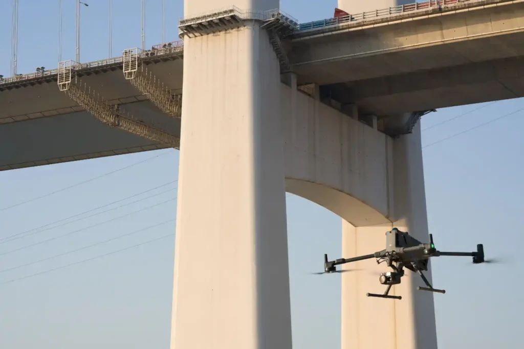
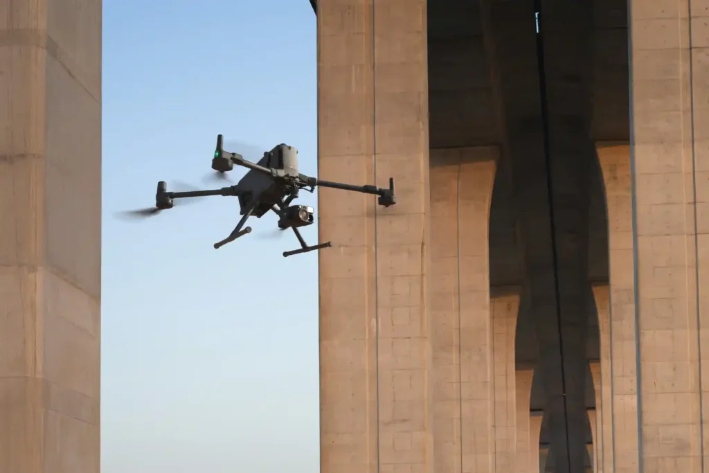
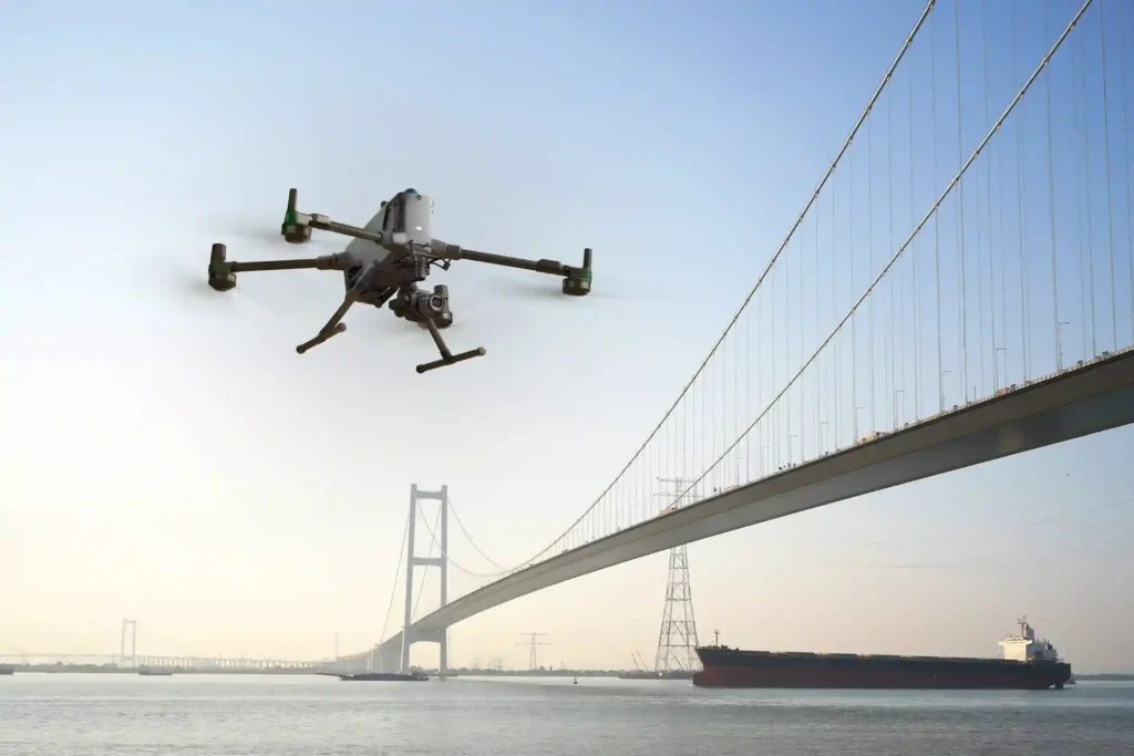
The Three-Dimensional Integrity Challenge Managing major infrastructure from long-distance pipelines and highways to offshore oil facilities, is a massive task. Asset owners in the MENA region face the immense challenge of maintaining structural health across all three major environments: air (high-altitude assets), land (linear corridors), and sea (submerged foundations). The traditional approach to managing these assets is severely flawed. Manual surveys on land, reliance on dangerous scaffolding or rope access in the air, and sending human divers into dark, high-risk waters (Sea) are slow, dangerous, and create fragmented data. This leaves asset owners vulnerable to unexpected failure and huge repair costs. Modern asset management demands a unified solution. It requires a specialized, robotic approach capable of performing objective, centimeter-accurate inspections in every domain. This necessary shift leads to the core of our strategy: full-spectrum asset inspection, utilizing specialized robotics and sensors to create one unified source of truth for the entire asset portfolio. The Land and Air Domains The beginning of the full-spectrum approach focuses on digitizing the vast surfaces of land and the complex vertical structures above ground. I. Land Inspection: Mapping the Foundation and Corridor Land assets including highways, pipelines, and industrial facilities, suffer from time delays and difficult access points during inspections and surveys. We overcome these challenges through integrated geospatial and robotic solutions. LiDAR and Photogrammetry: We use integrated aerial LiDAR systems to create the accurate Digital Terrain Model (DTM) needed for precise road and pipeline routing. Photogrammetry then provides the necessary high-resolution visual context. This initial Topographic Mapping is crucial for checking and verifying design against reality before construction proceeds. External Land Inspection: For inspecting rough terrain, checking pipeline integrity, or navigating hazardous ground areas beneath equipment (under-skids), we deploy advanced Deep Robotics platforms. These specialized ground robots access dangerous environments that are too unstable or confined for human inspectors, performing detailed visual and non-contact checks on assets. Internal Land Access (Confined Space): Even internal land structures like large ducts, vessels, or complex pipes require checks. For these challenging spaces where GPS signals fail, we use the Terra Xross 1 drone. This protected, cage-equipped drone flies safely inside these vessels, collecting high-resolution visual data to check for corrosion and structural issues, eliminating the need for human entry into hazardous atmospheres. Application: This combined data flow is used for rapid Topographic Mapping, volumetric analysis (earthwork optimization), and early design validation through BIM Integration. II. Aerial Inspection: Vertical Structures and Confined Spaces Vertical industrial structures from flare stacks and high piping to storage tanks present significant height risks. Our aerial inspection minimizes human exposure while delivering precise Non-Destructive Testing (NDT). Vertical NDT (Contact Inspection): For vital contact-based measurements, we deploy the Voliro T drone. This specialized aerial robot performs external, contact-based UT (Ultrasonic Thickness) Inspection and thermal scanning on challenging vertical and overhead assets, like tank walls and high piping. The Voliro T applies the stable force required to take precise thickness readings, verifying material integrity. High-Altitude Visual: We use standard industrial drones to perform rapid, high-resolution visual inspection of tall structures, roofs, and large-area piping, quickly identifying general wear or coating failure. Internal Safety (Confined Space): In large industrial vessels and tanks, the Terra Xross 1 drone ensures internal visual checks are performed safely and efficiently, further reducing personnel risk in hazardous, enclosed environments. The Sea and Synthesis Domains The third dimension of inspection, the marine environment is the most challenging. Successfully integrating this data creates the core of the predictive strategy. III. Sea Inspection: Qysea W6 NAVI for Coastal Resilience The safety risks, limited visibility, and time constraints of human divers make robotic inspection non-negotiable for subsea assets. Problem Solved: Our solution eliminates diver risk, time constraints, and low data quality in subsea environments. The Technology (W6 NAVI): We utilize the Qysea Maritime ROV W6 NAVI as the precision platform for underwater inspection. This compact, robust ROV is designed for stability and advanced data acquisition in open sea and port environments. Key Capabilities (W6 NAVI): The W6 NAVI provides several vital functions: Precision Navigation: It achieves enhanced hovering stability even in high currents, which is essential for accurate data collection near structures. Robust Surveys: It supports continuous, automated survey paths for consistent, repeatable data acquisition. Sonar and Payloads: It utilizes specialized scanning sonar to navigate in zero visibility conditions and carries modular payloads, including those necessary for subsea NDT and structural measurement. Application: The W6 NAVI is critical for inspecting subsea pipelines, performing scour assessment (foundation erosion) around jetties, and checking hull integrity. IV. The Predictive Synthesis: The Full-Spectrum Digital Twin The strategic value of full-spectrum asset inspection is realized by merging the data from all three domains (air, land, sea) into one cohesive, predictive platform. Data Fusion: We combine the DTMs (Land), the UT measurements (Air), and the sonar/scour data (Sea) into a unified dataset. The Digital Twin: This unified dataset creates the Digital Twin, a living, virtual replica of the entire asset portfolio. This advanced digital model allows asset managers to move beyond simple mapping and into true simulation. Value and RUL: The Digital Twin enables managers to perform remaining useful life (RUL) calculations and simulate future structural degradation. This unified approach provides objective, predictive maintenance insights, allowing clients to replace emergency spending with proactive, optimized resource allocation across the entire asset portfolio. Securing Integrity and Leadership The transition to a digital, holistic inspection strategy is essential for securing operational longevity and supporting Vision 2030’s infrastructure goals. Implement a full-spectrum asset inspection strategy of your infrastructure for long-term safety, efficiency, and predictive control. Let’s Talk!
The Coastal Imperative: Why ROV-Based Monitoring is Essential for Maintaining Saudi Vision 2030’s Offshore and Port Infrastructure.
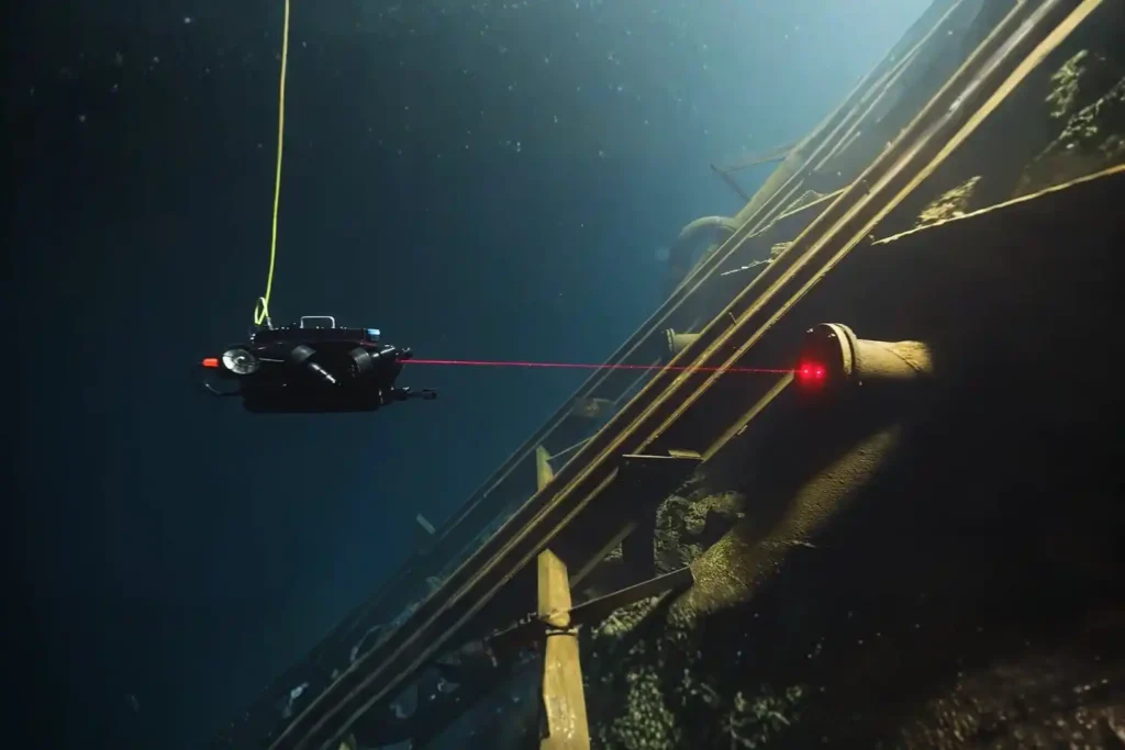
The Challenge Beneath the Surface The foundations of the MENA economy, jetties, bridges, seawalls, port facilities, and offshore energy platforms. They rely on submerged infrastructure. These assets face a brutal, unseen enemy: the marine environment. Constant exposure to seawater, which is highly corrosive, leads to material loss. This structural decay is worsened by biofouling, the rapid growth of marine organisms that attach to surfaces and accelerate corrosion. These environmental stressors lead to structural fatigue and threaten the longevity of vital infrastructure. The traditional approach to inspection only compounds the problem: Safety, Risk, and Accessibility: Inspecting submerged assets typically requires human divers. This process is inherently risky due to high currents, low visibility, and deep or confined spaces e.g. storage tank. Human divers are physically limited in depth and endurance, restricting their bottom time to one or two hours. High Cost and Downtime: Diver-based inspections are costly and time-consuming, requiring extensive coordination and specialized teams. For assets like fuel tanks, inspection often requires draining the tank, halting operations, and causing significant revenue loss. Data Quality: Diver reports are often subjective, lack precise location data (geotagging), and are difficult for engineers to rely on for long-term predictive models. The region urgently needs a safer, more efficient, and data-driven way to manage its critical maritime assets. The Rise of ROV-Based Monitoring Remotely Operated Vehicles (ROVs) are robotic systems that are transforming underwater inspection workflows by eliminating the need for human presence in high-risk zones. This technology has moved from specialized offshore use to become the standard for routine ROV-based monitoring for marine inspection assets. I. Advanced Technologies for Unseen Environments Inspection-class ROVs are compact, agile, and equipped with a versatile sensor suite designed to overcome the limitations of the marine environment. Visual and Sonar Imaging: ROVs use high-definition cameras and bright LED lighting to provide unparalleled visibility in clear water. More critically, they carry multibeam or scanning sonar for navigation and imaging in areas with poor visibility, such as murky water or sediment-rich areas. Sonar emits sound waves to create a clear picture of the environment, even when the operator cannot see. Navigation and Positioning: Advanced systems leverage DVL (Doppler Velocity Log) and U-INS (Underwater Inertial Navigation System) to ensure stable control and precise positioning. This means the ROV can hover automatically in turbulent conditions and record the exact GPS coordinates of every finding (geotagging), allowing for easier data correlation later. Core Payloads: ROVs are modular and can carry essential tools, including laser scaling devices for precise measurement, environmental sensors (temperature, salinity), and Ultrasonic Thickness (UT) gauges for Non-Destructive Testing (NDT). II. Applications Across Marine Infrastructure ROV-based monitoring for marine inspection assets is suitable for virtually all submerged structures: Port Facilities and Jetties: ROVs inspect submerged concrete degradation, scour (erosion around foundations), joint separations, and piling integrity. Offshore Energy: They assess corrosion, marine growth, and cathodic protection anodes around platform jackets, risers, and offshore wind turbine foundations. Vessels and Confined Spaces: Shipowners use ROVs for underwater hull inspection and ballast tank checks, often eliminating the need for costly dry docking. Pipelines and Cables: ROVs perform routine checks for corrosion, sediment buildup, structural anomalies, and accurate depth-of-burial surveys. From Reactive to Predictive Maintenance The immediate deployment and continuous operation of ROVs transform asset care from a reactive, emergency response into a proactive, data-driven strategy. III. Enabling Proactive Asset Management Reduced Human Risk and Downtime: The primary gain is safety. ROVs operate in challenging conditions such as extreme depths, high currents, and contaminated waters, eliminating risks to human divers. Furthermore, ROVs can be deployed in minutes and operate continuously without the time restrictions of human divers, ensuring operational continuity. Quantitative Corrosion and Damage Assessment: Equipped with UT gauges, ROVs perform precise NDT, measuring wall thickness to determine corrosion and material loss. The data collected is highly traceable and auditable. Continuous Monitoring for Early Detection: The low cost and rapid deployment encourage more frequent inspections. This continuous monitoring allows owners to detect minor anomalies early, preventing small cracks or corrosion spots from escalating into severe structural failures. Digital Twin Integration: The high-resolution video, sonar images, and UT measurements are stored in cloud platforms like Terra 3D Inspect. This data builds and updates the asset’s digital twin, a virtual replica that allows managers to run simulations, forecast structural decay, and schedule maintenance precisely, maximizing the asset’s lifespan. IV. Powering the Underwater Inspection The ability to successfully transition to predictive maintenance relies entirely on the quality and stability of the hardware capturing the data. For high-stakes subsea inspection, Terra Drone Arabia partners with world-leading technology providers to ensure mission success. This is where the specialized capabilities of QYSEA robotic systems come into play. A. The Precision Platform The QYSEA W6 NAVI is a specialized Maritime ROV designed to bring precision and versatility to the challenging conditions of open-sea environments and complex port facilities. This system acts as a central data hub, ensuring stable and reliable acquisition for all subsea inspection data. The W6 NAVI’s technical capabilities directly support the advanced requirements of ROV-based monitoring for marine inspection assets: Precise Navigation and Stability: The system enables precise navigation and enhanced hovering stability. This is critical for performing detailed work near structures, especially in high-current or turbulent waters where manual control is difficult. Robust Surveys: The W6 NAVI supports robust surveys and automated operations. This allows the platform to perform continuous, repeatable inspection paths, ensuring consistent data quality for comparative analysis over time. Open Sea Versatility: Its design specifically handles the demands of open-sea environments. This confirms its suitability for inspecting offshore assets and long subsea pipelines that require working far from shore. Full Asset Visibility Integration: The high-quality, geotagged data collected by the W6 NAVI is essential for the holistic approach. This data is integrated with aerial (drone LiDAR) and terrestrial data, ensuring full 360° asset visibility. By deploying specialized tools like the QYSEA W6 NAVI, we ensure that every inspection mission from scour assessment to hull integrity is conducted with the highest levels of stability and data
ROV-Based Monitoring for Marine Infrastructure and Coastal Inspection Assets
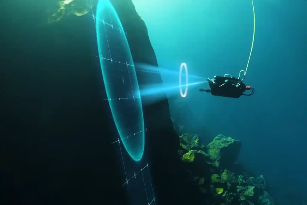
The Challenge Beneath the Surface The foundations of the MENA economy—jetties, bridges, seawalls, port facilities, and offshore energy platforms—rely on submerged infrastructure. These assets face a brutal, unseen enemy: the marine environment. Constant exposure to seawater, which is highly corrosive, leads to material loss. This structural decay is worsened by biofouling—the rapid growth of marine organisms that attach to surfaces and accelerate corrosion. These environmental stressors lead to structural fatigue and threaten the longevity of vital infrastructure. The traditional approach to inspection only compounds the problem: Safety, Risk, and Accessibility: Inspecting submerged assets typically requires human divers. This process is inherently risky due to high currents, low visibility, and deep or confined spaces. Human divers are physically limited in depth and endurance, restricting their bottom time to one or two hours. High Cost and Downtime: Diver-based inspections are costly and time-consuming, requiring extensive coordination and specialized teams. For assets like fuel tanks, inspection often requires draining the tank, halting operations, and causing significant revenue loss. Data Quality: Diver reports are often subjective, lack precise location data (geotagging), and are difficult for engineers to rely on for long-term predictive models. The region urgently needs a safer, more efficient, and data-driven way to manage its critical maritime assets. The Rise of ROV-Based Monitoring Remotely Operated Vehicles (ROVs) are robotic systems that are transforming underwater inspection workflows by eliminating the need for human presence in high-risk zones. This technology has moved from specialized offshore use to become the standard for routine ROV-based monitoring for marine inspection assets. I. Advanced Technologies for Unseen Environments Inspection-class ROVs are compact, agile, and equipped with a versatile sensor suite designed to overcome the limitations of the marine environment. Visual and Sonar Imaging: ROVs use high-definition cameras and bright LED lighting to provide unparalleled visibility in clear water. More critically, they carry multibeam or scanning sonar for navigation and imaging in areas with poor visibility, such as murky water or sediment-rich areas. Sonar emits sound waves to create a clear picture of the environment, even when the operator cannot see. Navigation and Positioning: Advanced systems leverage DVL (Doppler Velocity Log) and U-INS (Underwater Inertial Navigation System) to ensure stable control and precise positioning. This means the ROV can hover automatically in turbulent conditions and record the exact GPS coordinates of every finding (geotagging), allowing for easier data correlation later. Core Payloads: ROVs are modular and can carry essential tools, including laser scaling devices for precise measurement, environmental sensors (temperature, salinity), and Ultrasonic Thickness (UT) gauges for Non-Destructive Testing (NDT). II. Applications Across Marine Infrastructure ROV-based monitoring for marine inspection assets is suitable for virtually all submerged structures: Port Facilities and Jetties: ROVs inspect submerged concrete degradation, scour (erosion around foundations), joint separations, and piling integrity. Offshore Energy: They assess corrosion, marine growth, and cathodic protection anodes around platform jackets, risers, and offshore wind turbine foundations. Vessels and Confined Spaces: Shipowners use ROVs for underwater hull inspection and ballast tank checks, often eliminating the need for costly dry docking. Pipelines and Cables: ROVs perform routine checks for corrosion, sediment buildup, structural anomalies, and accurate depth-of-burial surveys. From Reactive to Predictive Maintenance The immediate deployment and continuous operation of ROVs transform asset care from a reactive, emergency response into a proactive, data-driven strategy. III. Enabling Proactive Asset Management Reduced Human Risk and Downtime: The primary gain is safety. ROVs operate in challenging conditions such as extreme depths, high currents, and contaminated waters, eliminating risks to human divers. Furthermore, ROVs can be deployed in minutes and operate continuously without the time restrictions of human divers, ensuring operational continuity. Quantitative Corrosion and Damage Assessment: Equipped with UT gauges, ROVs perform precise NDT, measuring wall thickness to determine corrosion and material loss. The data collected is highly traceable and auditable. Continuous Monitoring for Early Detection: The low cost and rapid deployment encourage more frequent inspections. This continuous monitoring allows owners to detect minor anomalies early, preventing small cracks or corrosion spots from escalating into severe structural failures. digital twin Integration: The high-resolution video, sonar images, and UT measurements are stored in cloud platforms like Terra 3D Inspect. This data builds and updates the asset’s digital twin, a virtual replica that allows managers to run simulations, forecast structural decay, and schedule maintenance precisely, maximizing the asset’s lifespan. IV. Synergy with Full Asset Visibility The underwater data is far more valuable when combined with aerial and terrestrial data. Our workflow integrates ROV bathymetry and scour data with drone LiDAR surveys of the dry dock and pier structures above the water line. This holistic approach provides complete, 360° asset visibility, moving beyond the subsea environment alone. Advancing Coastal Resilience with Smart Inspection The integration of remote technology is no longer optional; it is essential for supporting sustainable coastal and offshore infrastructure development under Saudi Vision 2030. Adoption Mandate: Organizations must adopt ROV-based monitoring for marine inspection assets as a cornerstone of their asset integrity programs. The cost benefits, avoiding drainage, reducing labor, and preventing downtime far exceed the cost of the technology itself, often providing a payback period of less than one year. Standardization and Integration: We encourage the integration of ROV data into existing GIS and digital twin systems for seamless lifecycle tracking. Partnering for Expertise: Terra Drone Arabia offers a complete suite of solutions, combining specialized expertise in subsea data acquisition with world-leading technology. We partner with innovators like QYSEA Technology to utilize ROVs (like the FIFISH Expert series) that are compact, maneuverable, and equipped with AI-enabled navigation and sonar systems. Our certified team ensures safe, efficient deployment and delivers actionable insights. Secure the long-term integrity of your marine assets. Contact us to discuss implementing an ROV pilot program and transforming your maintenance strategy from reactive to predictive.
Save 95℅ Time with Drone-Based Corrosion Inspection for Assets
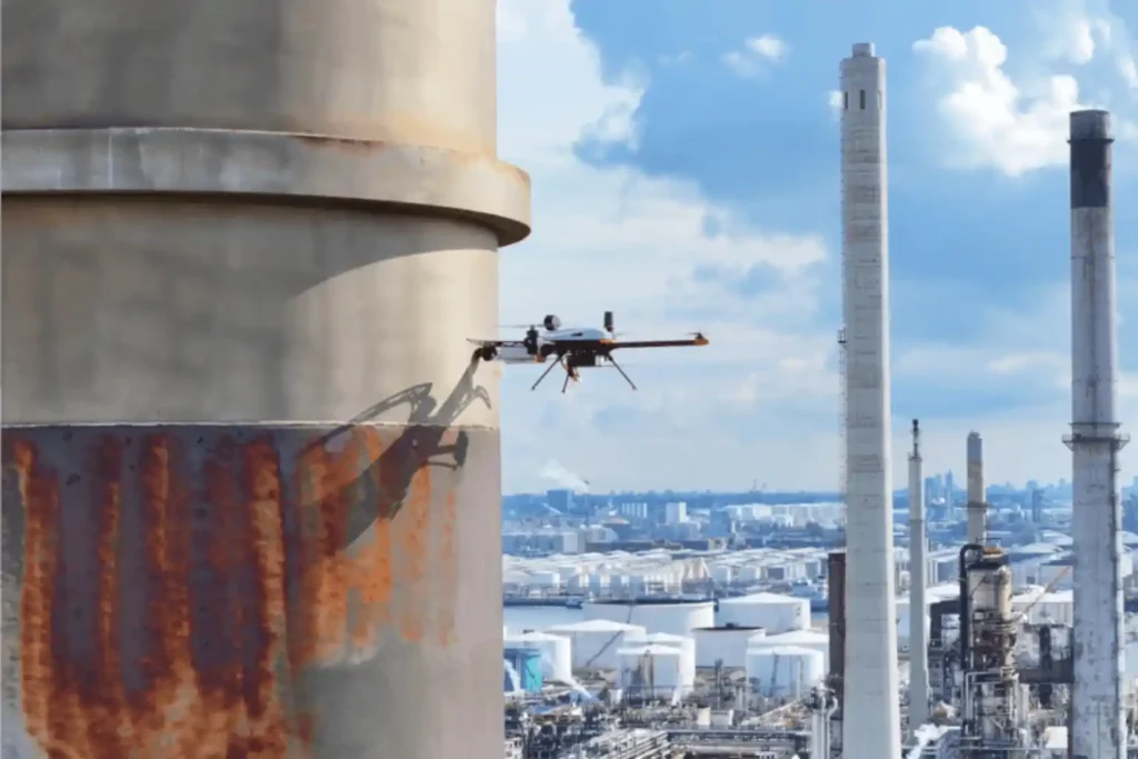
The Corrosion Inspection Challenge Corrosion is the silent and relentless enemy of metal assets—it remains the leading cause of unplanned shutdowns, containment failures, and devastating safety risks across the oil & gas, petrochemical, and heavy industrial sectors. In the demanding environments of the MENA region, assets like storage tanks, pipelines, and flare stacks face extreme pressure and must maintain peak structural integrity. The conventional methods for fighting corrosion are simply no longer good enough. Scaffolding and Time: Traditional inspections require extensive, costly scaffolding or rope access, shutting down operations for days or weeks. This severely impacts productivity. Safety Risks: Inspectors must enter hazardous confined spaces or climb hundreds of meters above the ground, exposing them to significant dangers. Manual Data: Manual Ultrasonic Thickness (UT) checks are subjective, slow, and often provide data that is difficult to trace and integrate into digital asset management systems. Industry urgently needs a safer, faster, and more data-rich way to assess asset health. The solution is the convergence of aerial technology and specialized testing: corrosion inspection with drone-based visual and UT systems. Integrating Visual and Ultrasonic Thickness (UT) Drones The future of asset integrity lies in non-contact aerial access combined with contact-based measurement precision. Drone technology now provides a complete, two-part inspection solution. I. High-Resolution Visual Inspection Visual drones start the process by quickly capturing comprehensive data on the asset’s exterior. Complete Coverage: Drones fly precise, automated paths around tanks, pipelines, and stacks, collecting high-resolution imagery. This imagery builds a precise 3D model (photogrammetry) of the asset. Defect Mapping: Specialized cameras detect and map all surface defects, such as paint degradation, coating loss, signs of external corrosion, and cracking. This creates a digital record showing the location and size of every visible fault. Efficiency Metric: By eliminating the manual setup time, drone technology can reduce the time required for complex tank or flare stack inspections by up to 95% compared to traditional scaffolding or rope access methods, delivering immediate time and cost savings. II. Drone Equipment Solution: The Hardware Behind the Data Terra Drone Arabia delivers advanced results by operating both proprietary solutions and specialized hardware designed for harsh industrial environments. Our fleet is purpose-built to execute both visual and contact-based NDT with exceptional stability and accuracy. Visual Platforms: For initial high-resolution assessment and long-range mapping, our solutions rely on robust, enterprise-grade multirotor platforms. These systems carry high-resolution cameras and thermal sensors, enabling fast, safe visual coverage of vast industrial footprints. Voliro T for Contact NDT: For vital external contact-based measurements, we deploy the Voliro T drone. This aerial robotic platform is uniquely engineered with omnidirectional flight capabilities and tiltable rotors. This allows the drone to apply stable, measurable force to vertical or overhead metal surfaces for accurate UT measurement. Terra Xross 1 for Confined Space: For internal, indoor inspections where GPS signals fail, we use the Terra Xross 1. This drone features a protective cage and specialized sensors to navigate safely inside tanks, vessels, and chimneys. It collects vital visual data in dark, enclosed spaces, eliminating the need for human entry into hazardous atmospheres. III. Ultrasonic Thickness (UT) for Material Loss The crucial step for determining true structural integrity is measuring wall thickness. Advanced aerial robotic platforms like the Voliro T now perform this Non-Destructive Testing (NDT) task. Contact Measurement: The Voliro T drone carefully approaches the metal surface of the asset be it the roof of a storage tank or a vertical wall and gently places a contact sensor on the surface. This stable contact allows the Voliro T to measure the wall thickness from the outside. Corrosion Detection: By comparing this measured thickness to the original blueprint specification, we immediately detect corrosion and material loss. This confirms whether the asset remains structurally sound. Data Traceability: The UT reading is captured digitally, stamped with its exact GPS location, and immediately linked to a photograph of the contact point. This provides auditable data that meets the strict traceability requirements of industry standards. Technical and Operational Benefits Adopting corrosion inspection with drone-based visual and UT systems delivers clear, quantifiable advantages for safety, finance, and long-term planning. IV. Technical and Operational Benefits of Drone NDT The fusion of aerial access and digital NDT transforms risk management into a strategic asset. A. Safety and Efficiency Gains Zero High-Altitude Risk: Drones perform all inspections—from pipe racks to flare stack tips—without putting a single worker at risk of falling or entering a dangerous atmosphere. Confined Space Safety: Using drones like the Terra Xross 1 for internal inspections ensures personnel do not enter hazardous vessels, directly solving a major industry safety issue. Minimal Shutdown Time: Drones perform inspections much faster, allowing facilities to maintain operational continuity. This significantly cuts downtime and maximizes productivity. This enhanced safety record supports ISO 45001 occupational health standards. Efficiency: Drone inspection missions are quick. When compared to the weeks needed for scaffolding, drone operations reduce inspection time by up to 70% for an asset, saving labor and rental costs. B. Accuracy and Predictive Maintenance Consistent Data: Drone flight paths are automated and repeatable. This ensures every inspection captures data from the exact same location as the previous one, providing reliable change detection over time. Traceable UT Data: Drone UT data is recorded with precise GPS location and photo documentation, providing level 3 traceability that meets API 653 standards, which governs above-ground storage tank inspection. This removes the subjectivity often found in manual reports. digital twin Integration: All visual maps, defect locations, and UT thickness measurements are immediately integrated into the asset’s digital twin. This living replica allows managers to perform predictive maintenance and accurately calculate the asset’s remaining useful life (RUL). C. Compliance and Standardization The use of drone technology supports major regulatory frameworks, ensuring structural integrity compliance. Integrity Standards: Drone NDT techniques support inspection requirements under standards such as API 653 (Storage Tanks) and ISO 9712 (Qualification of NDT Personnel). Standardization: As drone technology matures, collaborating with inspection bodies helps standardize these UAV-based NDT workflows, securing the technology’s place as a primary integrity
Revolutionizing Corrosion Inspection With Drone-based Visual and UT Systems
The Corrosion Inspection Challenge Corrosion is the silent and relentless enemy of metal assets—remains the leading cause of unplanned shutdowns, containment failures, and devastating safety risks across the oil & gas, petrochemical, and heavy industrial sectors. In the demanding environments of the MENA region, assets like storage tanks, pipelines, and flare stacks face extreme pressure and must maintain peak structural integrity. The conventional methods for fighting corrosion are simply no longer good enough. Scaffolding and Time: Traditional inspections require extensive, costly scaffolding or rope access, shutting down operations for days or weeks. This severely impacts productivity. Safety Risks: Inspectors must enter hazardous confined spaces or climb hundreds of meters above the ground, exposing them to significant dangers. Manual Data: Manual Ultrasonic Thickness (UT) checks are subjective, slow, and often provide data that is difficult to trace and integrate into digital asset management systems. Industry urgently needs a safer, faster, and more data-rich way to assess asset health. The solution is the convergence of aerial technology and specialized testing: corrosion inspection with drone-based visual and UT systems. Integrating Visual and Ultrasonic Thickness (UT) Drones The future of asset integrity lies in non-contact aerial access combined with contact-based measurement precision. Drone technology now provides a complete, two-part inspection solution. I. High-Resolution Visual Inspection Visual drones start the process by quickly capturing comprehensive data on the asset’s exterior. Complete Coverage: Drones fly precise, automated paths around tanks, pipelines, and stacks, collecting high-resolution imagery. This imagery builds a precise 3D model (photogrammetry) of the asset. Defect Mapping: Specialized cameras detect and map all surface defects, such as paint degradation, coating loss, signs of external corrosion, and cracking. This creates a digital record showing the location and size of every visible fault. Efficiency Metric: By eliminating the manual setup time, drone technology can reduce the time required for complex tank or flare stack inspections by up to 95% compared to traditional scaffolding or rope access methods, delivering immediate time and cost savings. II. Drone Equipment Solution: The Hardware Behind the Data (New Section) Terra Drone Arabia delivers advanced results by operating both proprietary solutions and best-in-class specialized hardware designed for harsh industrial environments. Our fleet is purpose-built to execute both visual and contact-based NDT with exceptional stability and accuracy. A. Voliro T for Contact NDT For vital contact-based measurements, we deploy the Voliro T drone. Unique Design: The Voliro T is an aerial robotic platform uniquely engineered with omnidirectional flight capabilities and tiltable rotors. This allows the drone to approach vertical or overhead metal surfaces from any angle and apply stable, measurable force. UT Payload: The Voliro T, equipped with an Ultrasonic Transducer (UT) probe, performs precise, stable contact NDT. This specialized function is essential for accurate wall thickness measurement in high-altitude areas. B. High-Endurance Visual Platforms For long-range corridor mapping and initial high-resolution visual assessment, our inspection solutions rely on robust, enterprise-grade multirotor platforms. These systems carry high-resolution cameras and thermal sensors, enabling fast, safe visual coverage of vast industrial footprints and linear pipelines. C. Ultrasonic Thickness (UT) for Material Loss The crucial step for determining true structural integrity is measuring wall thickness. The Voliro T now performs this Non-Destructive Testing (NDT) task. Contact Measurement: The Voliro T drone carefully approaches the metal surface of the asset, be it the roof of a storage tank or a vertical wall—and gently places a contact sensor on the surface. This stable contact allows the Voliro T to measure the wall thickness from the outside. Corrosion Detection: By comparing this measured thickness to the original blueprint specification, we immediately detect corrosion and material loss. This confirms whether the asset remains structurally sound. Data Traceability: The UT reading is captured digitally, stamped with its exact GPS location, and immediately linked to a photograph of the contact point. This provides auditable data that meets the strict traceability requirements of industry standards. Technical and Operational Benefits Adopting corrosion inspection with drone-based visual and UT systems delivers clear, quantifiable advantages for safety, finance, and long-term planning. III. Technical and Operational Benefits of Drone NDT The fusion of aerial access and digital NDT transforms risk management into a strategic asset. A. Safety and Efficiency Gains Zero High-Altitude Risk: Drones like the Voliro T perform all inspections—from pipe racks to flare stack tips—without putting a single worker at risk of falling or entering a dangerous atmosphere. Minimal Shutdown Time: Drones perform inspections much faster, allowing facilities to maintain operational continuity. This significantly cuts downtime and maximizes productivity. This enhanced safety record supports ISO 45001 occupational health standards. Efficiency: Drone inspection missions are quick. When compared to the weeks needed for scaffolding, drone operations reduce inspection time by up to 70% for an asset, saving labor and rental costs. B. Accuracy and Predictive Maintenance Consistent Data: Drone flight paths are automated and repeatable. This ensures every inspection captures data from the exact same location as the previous one, providing reliable change detection over time. Traceable UT Data: Drone UT data is recorded with precise GPS location and photo documentation, providing level 3 traceability that meets API 653 standards, which governs above-ground storage tank inspection. This removes the subjectivity often found in manual reports. Digital Twin Integration: All visual maps, defect locations, and UT thickness measurements are immediately integrated into the asset’s digital twin. This living replica allows managers to perform predictive maintenance and accurately calculate the asset’s remaining useful life (RUL). C. Compliance and Standardization The use of drone technology supports major regulatory frameworks, ensuring structural integrity compliance. Integrity Standards: Drone NDT techniques support inspection requirements under standards such as API 653 (Storage Tanks) and ISO 9712 (Qualification of NDT Personnel). Standardization: As drone technology matures, collaborating with inspection bodies helps standardize these UAV-based NDT workflows, securing the technology’s place as a primary integrity tool. Toward Intelligent Corrosion Management The era of slow, dangerous, and subjective industrial inspections is ending. The high-resolution, centimeter-accurate data delivered by corrosion inspection with drone-based visual and UT systems is the central component of intelligent asset management strategies
How Geospatial Intelligence Powers Predictive Asset Management
The Operational Imperative The moment infrastructure like highways, bridges, and industrial assets finish construction, they enter a critical new phase: operational risk. Managing maintenance is the single largest long-term cost, and reactive failure, waiting for a fault before fixing it is unacceptable for any modern smart city. The challenge lies in inspection. Traditional integrity checks are slow, subjective, and inherently dangerous. They require costly actions like building scaffolding or closing traffic lanes. This process delivers low-volume, outdated data, locking asset managers into a dangerous cycle of reactive failure. The only effective solution is the digital twin, a virtual replica built on persistent, high-quality data. This digital twin, fueled by geospatial intelligence for smart city data, enables the fundamental shift to safe, objective, and predictive maintenance. The Data Foundation for Asset Integrity The operational success of a highway or an industrial plant starts with the quality of its initial survey data. This information creates the digital foundation for the entire asset lifecycle. I. Establishing the Digital Baseline for RUL Calculation All reliable long-term maintenance must start with a perfect measurement of the asset’s original, healthy state. A. The Geospatial Baseline The initial centimeter-accurate survey data collected using drone-based LiDAR and Photogrammetry creates the indispensable structural health baseline. This initial data is the only reference point against which all future material wear, structural cracks, and component degradation are measured. Without this accurate baseline, calculating deterioration is impossible. B. Data Chronology for RUL The ultimate goal of asset management is accurately forecasting failure. This is done through remaining useful life (RUL) calculation. RUL Definition: The RUL predicts how much longer an asset can operate safely before maintenance or replacement is necessary. Data Necessity: Accurately calculating RUL requires a consistent, chronological data feed. Drone technology provides this through repeatable missions (weekly or monthly flights) that document changes over time. Cost Benefit: Using this predictive data allows companies to shift maintenance spending from sudden, expensive emergencies to planned, controlled projects, maximizing the useful life of the asset. Advanced Integrity Checks and Simulation The Digital Twin’s predictive power is unlocked by combining the initial baseline data with continuous, non-contact integrity checks. II. Non-Contact Integrity and Defect Detection Drones perform essential, high-risk inspections without ever endangering human personnel or halting operations. A. Structural Health Monitoring Bridge Scanning: Drones fly precise, automated flight paths beneath complex highway structures and bridges. This non-contact method eliminates the cost of scaffolding and the risk of lane closures. Visual Data: High-resolution cameras scan for tiny surface defects like concrete cracks, spalling, and corrosion. Drone inspections can reduce asset inspection times by 4 times compared to manual methods, allowing for more frequent and proactive maintenance checks. Pavement Analysis: High-resolution drone cameras collect data used to map and classify pavement damage, such as cracking and rutting. This detailed information helps transportation agencies prioritize road repairs effectively. B. Specialized Non-Destructive Testing (NDT) Advanced payloads allow for structural health checks beyond simple visual inspection. Thermal Imaging: Thermal cameras detect temperature variations on surfaces like pavements or bridge decks. These temperature differences often reveal subsurface issues like water intrusion, poor drainage, or voids beneath the roadbed that human eyes cannot see. Early thermal mapping prevents minor moisture issues from growing into major structural failures. Confined Space Safety: Using small, specialized drones, we inspect hazardous and enclosed assets like boilers, storage tank interiors, and industrial vessels. This capability eliminates human risk and minimizes costly operational shutdown time. Drone UT: Drones equipped with ultrasonic thickness (UT) probes perform non-contact measurement of material thinning and corrosion in assets like storage tanks and pipe. This provides critical input for the predictive maintenance model. C. Predictive Simulation (The Digital Twin at Work) The Digital Twin consumes all this recurring inspection data (baseline + defects) to run simulations. Forecasting Failure: The twin runs predictive models that forecast when a structural element will reach its critical threshold (RUL). This allows asset managers to schedule repairs precisely, maximizing the useful life of the asset while minimizing costly downtime. Centralized Management: This platform ensures that all parts of the future smart city operate cohesively and efficiently, confirming that the foundation of the system is robust, up-to-date Geospatial Intelligence for Smart City data. Secure Your Operational Future The digital transformation of asset management moves highway and infrastructure care from reactive to predictive, objective, and safe. The use of continuous geospatial intelligence for smart city platforms ensures that infrastructure remains durable, efficient, and compliant with long-term goals. Terra Drone Arabia is your certified local partner. We possess the needed technical capacity and local compliance knowledge to deliver comprehensive geospatial data for every inspection mission. Accelerate your shift to predictive asset management and experience these efficiency gains with FREE 3-month progress monitoring on a key bridge or highway section. Let’s talk to your future-proof critical transportation network.
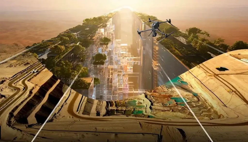
Precision Mapping: The Technical Core of High-Speed Highway Design
The foundational task of building or improving any major road, rail, or highway in the swiftly developing MENA region is topographic mapping. This process, which creates a three-dimensional model of the land’s surface, is not just a preliminary step; it dictates the engineering viability, the budget, and the ultimate timeline of the entire project. Yet, the intense pressure of Vision 2030 deadlines has created a crisis: the slow, dangerous, and low-density methods of the past simply cannot keep pace. We need a solution that is not just faster, but also more accurate. The answer is the intelligent integration of advanced drone technology. The future of linear infrastructure hinges on the integrated process of aerial topographic mapping, combining LiDAR and Photogrammetry to create a perfect digital foundation for accelerated design and compliance. The Geospatial Imperative The economic stability and successful completion of giga-projects depend on fast, reliable survey data. The cost of relying on traditional methods—using manual GNSS rovers or Total Stations—is no longer acceptable. The Time-to-Data Crisis For long, linear projects like new highways, manual surveying is inherently slow and logistically complex. Low Data Density: Traditional methods rely on measuring individual, selected points3. This results in a sparse dataset that is often insufficient for the detailed volumetric and alignment checks required by modern engineering standards4. Safety and Accessibility Risks: Survey teams must be physically present on the ground, often working on steep slopes, near heavy machinery, or close to active traffic555. This introduces significant safety risks and slows work for compliance6. Design Lag: The time needed to complete a manual survey of a long corridor can lead to a severe Time-to-Data crisis7. By the time the data is processed, ground conditions may have already changed, forcing costly design adjustments or rework8. The only way forward is a solution that can capture data at a density measured in millions of points per second, safely, and from the air. Building the Perfect Digital Terrain Model (DTM) The core of highway acceleration is the shift to high-precision, non-contact data capture that guarantees accuracy for civil engineering design. This process relies entirely on a technical partnership between two sensor types. I. High-Fidelity Data Capture: The LiDAR and Photogrammetry Duo The initial phase of any highway project is critical for budget and safety9. Drones transform this process into a fully transparent, digitally integrated workflow10. A. LiDAR for True Terrain Modeling (DTM): The Geometric Foundation LiDAR systems provide the most geometrically accurate data needed for civil engineering design, especially where natural terrain is involved11. Pulse Technology and DTM: Our drone-mounted LiDAR systems are active sensors that emit millions of laser pulses per second, precisely measuring distance to create a three-dimensional point cloud12. Bare-Earth Penetration: The key technical strength is the ability to record multiple returns per laser pulse. This allows the system to effectively filter out surface features like scrub or construction debris, isolating the bare-earth Digital Terrain Model (DTM)13. This DTM is the non-negotiable geometric basis for calculating slope stability and precise road drainage14. Corridor Integrity: This data is used to define critical right-of-way boundaries and spot potential geological hazards along the lengthy highway corridor15. B. Photogrammetry for Visual Context and Textural Accuracy While LiDAR provides the geometric skeleton, photogrammetry supplies the high-resolution visual context needed for design review and documentation. Creating the Auditable Orthomosaic: Drones capture thousands of high-resolution, overlapping images that are processed into a single, seamless Orthomosaic Map16. This map is geometrically corrected and precisely aligned using RTK (Real-Time Kinematic) positioning, ensuring the visual data is just as accurate as the LiDAR geometry17171717. Subsurface Modeling: The initial survey data is also essential for integrating follow-on data, such as utility maps created through Ground Penetrating Radar (GPR)18. This provides a complete 3D picture of any existing underground utilities that could conflict with the new highway design19. Operational Value and Intelligence The speed of data capture must translate into provable efficiencies and high-quality results. This is where the integration of topographic mapping into the digital ecosystem pays off. II. Quality Control and Earthwork Efficiency During Construction The construction phase of a major highway is characterized by rapid change and high-stakes financial risk. Drones transition from initial surveyors to the project’s digital Quality Assurance (QA) engine. A. Earthwork Efficiency: Volumetrics and Digital Auditing Drones control the largest cost variables in highway construction, the movement and management of soil. Cut-and-Fill Verification: Automated drone flights capture ultra-high-density 3D data used to create digital elevation models (DEMs). By comparing the current DEM to the planned design surface, advanced software accurately performs cut-and-fill analysis. This ensures the correct quantity of material is being moved, preventing expensive shortages or over-excavation. Stockpile Auditing: The same high-accuracy model enables instant and precise stockpile calculation for materials like asphalt and aggregate. Project managers rely on this data for real-time inventory management. Rework Mitigation: This high-resolution data ensures that the ground surface aligns with design specifications before expensive paving begins. B. Progress Monitoring and Digital Twin Alignment Progress Tracking: Drones fly repeatable, automated routes to generate consistent, time-stamped orthomosaic maps. This creates an objective, visual timeline of the construction process. Design Compliance and Error Reduction: The drone data is digitally compared to the original BIM/CAD design model. This critical Drone-BIM integration has been shown to reduce design errors by up to 65%, allowing teams to catch conflicts early and drastically minimizing costly rework during the active construction phase. III. Beyond the Pavement: Safety, Traffic, and Asset Intelligence The overall intelligence derived from topographic mapping moves beyond the construction site into the operational life of the highway. A. Real-Time Traffic and Operational Safety Traffic Flow Analysis: Drones provide a consistent aerial perspective over high-traffic areas. AI algorithms process the video to automatically extract precise vehicle speeds and trajectories, which is essential for intelligent transportation systems (ITS) to optimize signal timing and forecast congestion. Accident Response: After an incident, drones quickly capture high-resolution imagery to reconstruct the accident scene accurately and quickly. B. Structural Health and the Digital Twin Highway Bridge and Pavement Inspection: Drones
From Survey to Digital Twin: The Technical Roadmap for Drone-Powered Highway Construction.
The vast, intricate road and highway network is the undisputed backbone of the modern economy, especially across the swiftly developing MENA region. These vital transportation arteries, which stretch across great distances, face constant challenges: rapid material breakdown from harsh climates, ceaseless heavy traffic, and the severe safety risks tied to manual maintenance. Inspecting and caring for these complex, linear assets—like elevated bridges and long corridors is a monumental logistical and safety puzzle. This immense responsibility calls for a fundamental shift: moving away from slow, expensive, and dangerous reactive maintenance toward intelligent, predictive asset care. The critical step in this transformation is the aerial perspective provided by Unmanned Aerial Systems (UAS) drones. Drones are now essential for modern infrastructure management because they offer unparalleled speed, high data accuracy, and enhanced personnel safety. This comprehensive editorial explores how drone technology provides immediate and lasting value across the entire infrastructure lifecycle, establishing a new, safer, and faster benchmark for highway inspection. The Infrastructure Imperative The economic stability and long-term safety of the Kingdom and the wider region depend heavily on keeping the transportation network sound. However, managing this immense asset base using traditional, manual methods is no longer a viable option. Manual inspection requires costly actions like closing traffic lanes, renting expensive equipment like scaffolding and cherry pickers, and, most critically, forcing human inspectors into high-risk zones, such such as elevated bridges or areas with heavy, fast-moving traffic. This old way is slow, dangerous, and extremely inefficient. The solution is digital, objective, and non-contact. The drone’s core strength is providing a detailed, repeatable aerial view, transforming the slow, dangerous process of highway inspection into a fast, digital, and fully auditable workflow. The total benefit of drone use touches every phase of a highway’s life from the initial blueprint to decades of operation. The Foundation and The Build The application of drone technology begins the moment a new road is planned, guaranteeing that the project starts with a perfect, high-quality digital foundation. I. Precision Mapping for New Design and Rehabilitation The initial phase of any highway project—whether building new roads or overhauling existing ones is the most critical for budget and safety. Drones transform this process from a guesswork exercise into a fully transparent, digitally integrated workflow. A. LiDAR for Digital Terrain Modeling (DTM) and Subsurface Integrity For linear infrastructure like highways, precise terrain data is non-negotiable. LiDAR systems provide the superior geometric accuracy needed for civil engineering design. The Technical Edge: Bare-Earth Penetration Pulse Technology: Our drone-mounted LiDAR systems are active sensors that emit millions of laser pulses per second, measuring distance by recording the time a pulse takes to return. This creates a high-density, three-dimensional point cloud. DTM Generation: The key technical advantage is the LiDAR’s ability to record multiple returns per laser pulse. This allows the system to effectively filter out surface features like scrub, trees, or construction debris, isolating the true ground elevation to create an accurate Digital Terrain Model (DTM). This DTM is the essential foundation for calculating road drainage, slope stability, and horizontal alignment. Corridor Integrity: This geometric data is used to identify precise gradient changes, define the critical right-of-way boundaries, and spot potential geological hazards along the lengthy highway corridor. Geometric Accuracy and Quality Assurance Centimeter Precision: High-end LiDAR and GNSS systems ensure the data is collected with centimeter-level accuracy, which is a requirement for 1:500 scale engineering surveys. Subsurface Modeling: The initial survey data is also essential for integrating follow-on data, such as utility maps created through Ground Penetrating Radar (GPR). This provides a complete 3D picture of any existing underground utilities (cables, pipelines) that could conflict with the new highway design. B. Photogrammetry for Visual Accuracy and Design Integration While LiDAR provides the geometric skeleton, photogrammetry supplies the visual texture and facilitates crucial digital checks against the design. Creating the Auditable Orthomosaic RTK Geo-referencing: Drones capture thousands of high-resolution, overlapping images that are processed into a single, seamless Orthomosaic Map. This map is geometrically corrected and precisely aligned using RTK (Real-Time Kinematic) positioning, ensuring the visual data is just as accurate as the LiDAR geometry. Visual Documentation: The Orthomosaic Map becomes the primary visual record for the project, showing existing infrastructure, land use, and site conditions without distortion, which is key for engineering review. Digital Integration and Error Mitigation BIM/CAD Workflow Acceleration: The processed photogrammetry and LiDAR data are immediately converted into formats that integrate seamlessly into BIM (Building Information Modeling) and CAD software. This direct flow minimizes the manual transcription errors common in legacy surveying. Design Validation: Engineers use the high-fidelity aerial data to overlay the planned highway design model onto the actual terrain data. This Drone-BIM integration has been shown to reduce design errors by up to \mathbf{65\%}, allowing teams to catch conflicts and discrepancies early, which saves massive amounts of money and time during the earthwork phase. Volumetric Analysis: The accurate digital elevation models (DTMs) are used for precise cut-and-fill analysis and material stockpile measurements, ensuring material logistics are optimized and budgets are strictly controlled. II. Quality Control and Earthwork Efficiency During Construction Once construction is active, drones become the project manager’s most reliable auditing tool, ensuring work meets the required quality and safety standards. A. Earthwork and Volumetric Analysis Accurate earthwork calculation is fundamental to controlling costs and material flow in highway construction. Cut-and-Fill Analysis: Frequent, automated drone flights capture 3D models used for precise cut-and-fill measurements and stockpile analysis. This ensures material logistics are optimized and prevents expensive overages or material shortages. Rework Mitigation: This high-resolution data ensures that the ground surface is prepared perfectly and aligns with design specifications before expensive asphalt paving begins. By feeding this up-to-date aerial survey data into digital models, Drone-BIM integration has been shown to reduce design errors by up to $\mathbf{65\%}$, significantly cutting down on rework. B. Real-Time Progress Monitoring and Safety Progress Tracking: Drones generate up-to-date 3D models to track physical progress against project milestones. This creates a reliable, objective, and visual timeline of the construction process. Site Safety: Drones quickly
From 6 Months to 3: The Reality Capture Revolution Driving Topographic Survey For Saudi Vision 2030
The scale and speed of construction across Saudi Arabia from NEOM to ROSHN are rewriting the global rules of project management. Under the demanding mandate of Vision 2030, a months-long delay in acquiring foundational data is no longer an option. Project timelines have compressed to the point where the traditional methods used for decades simply fail to keep pace. This urgent demand for speed and accuracy has driven the convergence of Digital Twins and Reality Capture technology to become the new geospatial standard. As a specialized provider in the Middle East, Terra Drone Arabia understands that the first step in building a smart city or giga-project is flawlessly mapping the ground it stands on. This in-depth look explores how drone-based Reality Capture has ignited a revolution in topographic surveying, delivering critical project data not just faster, but with superior quality, and fundamentally setting the stage for the creation of a dynamic digital twin. I. The Bottleneck: Why Traditional Surveying Can’t Deliver Vision 2030 To appreciate the scale of this technological leap, we must first recognize the fundamental limitations of the legacy methods that dominated surveying for decades. Project managers frequently encountered debilitating bottlenecks caused by reliance on ground-based techniques. A. The Six-Month Wait: A Necessary Evil of Legacy Systems Traditional large-scale topographic surveying heavily relies on a painstaking, point-by-point process involving Total Stations and ground-based GPS. For the vast, complex, and often rugged terrains characterizing Saudi giga-projects, this method presents multiple, non-negotiable pain points: Manpower and Time Constraints: The process demands massive field crews and extensive ground access. For an average large-scale project area, the logistical complexity alone meant waiting up to six months to compile the foundational topographic data. Safety Hazards: Deploying personnel into remote, high-altitude, or hazardous coastal environments to collect points creates significant safety risks, leading to costly compliance procedures and delays. Low Data Density: Ground-based techniques capture discrete points. When engineers need to move quickly, this data density can prove insufficient for detailed volumetric calculations or millimeter-accurate BIM integration. The six-month wait for foundational data became a project constraint, a necessary evil that Vision 2030’s accelerated timelines simply cannot afford. This market urgency created the perfect environment for a transformative solution. II. Reality Capture: The Geospatial Engine for Giga-Project Speed The solution to the six-month bottleneck is the aggressive adoption of Reality Capture—a technological shift that moves surveying from a point-measurement exercise to a continuous, ultra-high-density 3D data capture mission. A. The Drone Hardware Supremacy The modern Reality Capture ecosystem relies on multi-payload, heavy-lift platforms built for endurance and high precision, capable of operating reliably in the harsh Middle Eastern climate. Drone LiDAR: Terra Drone Arabia leverages proprietary systems like the Terra LiDAR One to transform data acquisition across the Kingdom. LiDAR sensors unleash millions of laser pulses per second, collecting massive geometric datasets that effectively penetrate vegetation to map bare earth terrain quickly. High-Resolution Photogrammetry: We also utilize best-in-class platforms like the DJI Matrice 400 (M400), which boasts robust all-weather performance and long flight times of up to 59 minutes, ideal for large area mapping. When equipped with the Zenmuse P1 sensor—featuring a 45MP full-frame sensor and a global mechanical shutter—this duo captures centimeter-accurate data for high-resolution 3D models and orthophotos. The M400 with P1 is specifically designed for large-scale surveying and mapping, covering substantial areas in a single flight and is critical for generating the textured, accurate models required for a digital twin. B. Quantifying the Transformation: 50% Time Reduction The efficiency gains are no longer theoretical; they are quantifiable and strategically vital for meeting the Kingdom’s deadlines. The Core Argument: While traditional large-scale topographic surveys take up to six months, an equivalent drone-based LiDAR survey cuts this time by a remarkable 50%, requiring only three months, ensuring giga-projects decisively meet aggressive deadlines. This transformation is achieved through streamlined data collection coupled with immediate data processing capabilities. Furthermore, Photogrammetry complements the LiDAR data by adding texture and visual orthophotos, enriching the captured geometric reality. III. Achieving Survey Grade Accuracy: Data Quality and Compliance The technical professional needs assurance: does this monumental speed sacrifice the necessary survey-grade accuracy? Modern Reality Capture maintains and often surpasses the accuracy standards of traditional methods. A. The Role of Precision Hardware Precision hinges on the quality of the drone’s platform and its advanced navigation systems. Our systems utilize integrated, survey-grade Inertial Measurement Units (IMU) and Global Navigation Satellite Systems (GNSS) to maintain centimeter-level precision. The Zenmuse P1, for example, achieves horizontal accuracy of 3 cm and vertical accuracy of 5 cm without Ground Control Points (GCPs) by utilizing its TimeSync 2.0 system and RTK positioning. This ensures that every one of the millions of captured points is georeferenced with the fidelity demanded by structural engineers and urban planners. B. Auditable Data Processing and Compliance Fast data collection is useless without a framework to process and validate it. This is where the Terra Drone Arabia data pipeline comes in: Quality Control: Platforms like Terra LiDAR Cloud and Terra Mapper process the raw data, performing calibration, classification, and detailed quality checks. This critical step ensures the integrity of the data and provides the auditable documentation necessary for compliance with stringent Saudi regulatory and project mandates. Seamless BIM/GIS Integration: The final reality capture output is delivered in formats perfectly tailored for immediate integration into Building Information Modeling (BIM) and Geospatial Information Systems (GIS) platforms. This instant interoperability allows engineers to immediately use the data for design validation, accelerating the project lifecycle. IV. Beyond Topography: Expanding Reality Capture Value The initial investment in drone-based Reality Capture for topographic surveying is not a one-off cost; it is the acquisition of a digital asset that unlocks ongoing value across the entire project lifecycle. A. Construction Progress and Volumetric Analysis The same high-accuracy data collection process can be applied weekly or even daily, providing unparalleled insight into construction progress. This means: Rapid Stockpile Calculation: Instant, accurate volume analysis of materials, moving beyond inaccurate manual estimates. Cut & Fill Analysis: Precise measurement of earthwork volumes, ensuring