The foundational work of building Saudi Arabia’s next-generation cities from the coastal developments of Red Sea Global to the vast infrastructure of NEOM begins with a single critical step: land surveying. This core discipline, often taken for granted, is the very first factor dictating a project’s timeline and budget. Yet, the relentless pace and massive scale of Vision 2030 demand an impossible standard that traditional methods simply cannot meet.
We have reached a pivotal moment where efficiency must fuse with unprecedented accuracy. The industry’s solution lies in the intelligent adoption of uncrewed aerial systems (UAS), ushering in the new age of digital geospatial capture. As technical leaders in the Middle East, Terra Drone Arabia recognizes that the future of infrastructure hinges on the seamless integration of Drone Photogrammetry and LiDAR Integration, a potent combination that is fundamentally transforming land surveying from a logistical challenge into a competitive advantage.
The Shift Toward Drone-Based Land Surveying
The foundational work of building Saudi Arabia’s next-generation cities from the coastal developments of Red Sea Global to the vast infrastructure of NEOM begins with a single critical step: land surveying.
A. The Technical Failure of Legacy Systems
For decades, Land Surveying relied on the painstaking work of field teams armed with terrestrial sensors. These conventional methods—principally Total Stations (TS) and network-based GNSS rovers—provided high point-accuracy but were inherently constrained by scale and terrain. For large-scale projects, this legacy system introduces severe technical limitations:
- Data Resolution and Density Bottleneck: Traditional methods rely on discrete point measurements. A surveyor manually chooses a point to measure, meaning the resulting Digital Terrain Model (DTM) or Digital Surface Model (DSM) is built from a relatively sparse dataset. This inherent lack of data density often proves insufficient for the millimetre-accurate BIM (Building Information Modeling) and complex CAD integration now mandated for modern giga-projects. The limited resolution makes automated clash detection and volumetric analysis key steps in Industry 4.0 workflows difficult or impossible.
- Geometric Inaccuracy in Obscured Terrain: Ground-based techniques struggle immensely with terrain changes obscured by vegetation, steep slopes, or areas with frequent shadow cover. Total Stations require line-of-sight, forcing multiple, time-consuming setups. For coastal projects requiring high-fidelity cliff or shoreline mapping, this presents a significant geometric challenge and a safety risk.
- Chronological Data Lag: The intensive manual labor required to cover a 10-square-kilometer site means the project’s foundational topographic data is often compiled over weeks or months. This chronological data lag creates a critical disparity between the existing ground truth and the digital model being used for design and earthworks calculation, leading to inevitable, costly rework downstream.
The Time-to-Data Crisis
Ultimately, the logistical complexity high manpower, extensive safety planning, and the sheer time required for sequential, manual data capture forces project managers into a six-month waiting period for their foundational topographic base. This systemic lag time is incompatible with the strategic vision of Saudi Arabia, where giga-projects require real-time validation and accelerated decision-making.
B. The Geospatial Mandate: Digitalization as a Non-Negotiable
The sheer scale of projects like NEOM, Qiddiya, and Red Sea Global—where areas span hundreds of kilometers and deadlines are non-negotiable—demanded a technological solution that could capture and process data instantaneously and comprehensively. The global industry migration to UAS is driven by quantifiable engineering benefits:
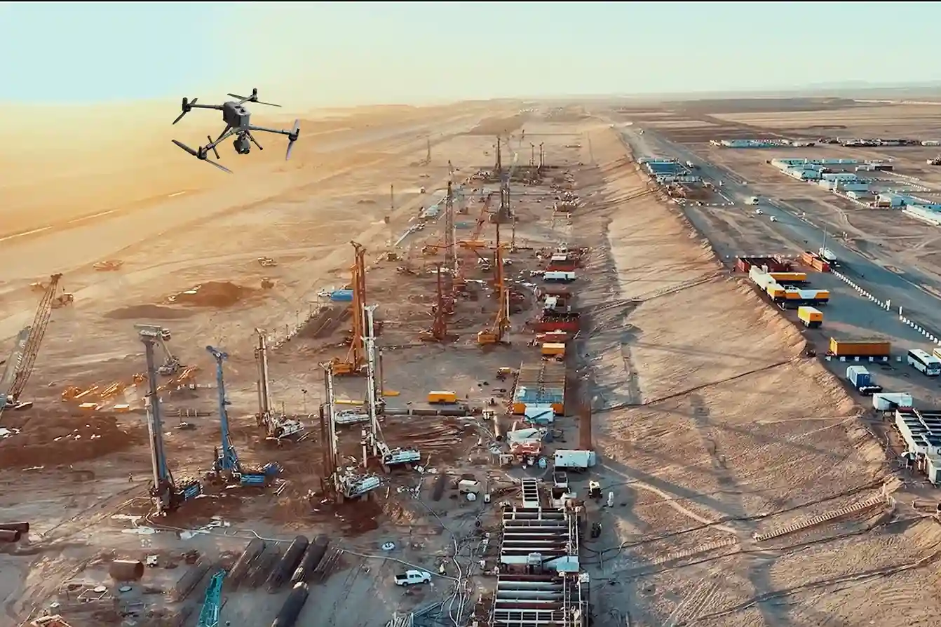
- UAS Platforms for Extended Coverage: Robust enterprise platforms like the DJI Matrice 400 (M400) provide long endurance (up to 59 minutes of flight time) and RTK accuracy, enabling single-flight coverage that compresses months of manual work into hours. The M400 is ideal for lengthy or remote surveying missions due to its extended flight time and range.
- High-Density Reality Capture: The ability to deploy non-contact sensors either active (LiDAR) or passive (Photogrammetry) collects data at a density measured in millions of points per second. This shift from sparse, manual points to high-density point clouds is the key technical enabler for creating the accurate, living geometric foundation necessary for a true Digital Twin.
- Mitigation of Safety Risk: By eliminating the need to put personnel on steep embankments, near active machinery, or within hazardous site zones, drone-based land surveying inherently complies with the strict ISO 45001 (Occupational Health and Safety) standards upheld by major clients like Aramco.
This urgent demand for fast, centimeter-accurate geospatial data to support BIM workflows, smart city planning, and environmental compliance has rendered traditional methodologies technically obsolete, making drone integration the essential strategy for modern land surveying.
Understanding the Technology

The transition to drone-based land surveying is defined by two primary technologies: Photogrammetry and LiDAR. While both deliver three-dimensional data, they operate on distinct technical principles, and understanding their complementarity is key to successful project execution.
A. Technical Principles and Complementarity
The art of effective Land Surveying lies not in choosing one technology, but in mastering the workflow that combines their strengths.
Photogrammetry: The High-Resolution Visual Engine
- Principle: Photogrammetry works by capturing hundreds or thousands of high-resolution, overlapping aerial images of a target area. Processing software then uses complex algorithms to identify common points across these images, triangulating their positions to generate a dense 3D point cloud, a geo-referenced orthomosaic map, and textured 3D models.
- Accuracy: Modern enterprise systems, such as the DJI Matrice 400 paired with the Zenmuse P1 full-frame camera, use Real-Time Kinematic (RTK) or Post-Processing Kinematic (PPK) corrections. This GPS correction technique eliminates the majority of Ground Control Points (GCPs) and ensures the captured data is geo-referenced with extremely high precision.
LiDAR: The Penetrating Geometric Scanner
- Principle: LiDAR (Light Detection and Ranging) is an active remote sensing technology. The sensor emits millions of laser pulses toward the ground. The time it takes for the pulse to return is measured, enabling the precise calculation of distance. The result is an immensely dense and highly accurate 3D point cloud.
- Advantage in Complexity: LiDAR excels in environments that defeat photogrammetry namely, areas with dense vegetation, complex utilities, or shadows. The Zenmuse L2 LiDAR, compatible with the M400, features superior penetration capabilities and can detect smaller objects with greater detail. Since a portion of the laser pulses can penetrate gaps in the canopy, LiDAR effectively maps the bare earth terrain beneath, creating a true Digital Terrain Model (DTM).
B. Quantifying Accuracy: Setting the Geospatial Standard
The defining metric for any survey technology is accuracy. For large engineering projects, the speed of drones is meaningless if the data quality falls short of regulatory standards.
Industry benchmarks for enterprise-grade RTK/PPK drone systems prove that high-speed capture does not compromise fidelity. Drone-based photogrammetry and LiDAR surveying now consistently achieve a Ground Sample Distance (GSD) of 1 cm/pixel and a vertical accuracy (RMSE) of less than 5 cm without extensive GCPs, meeting the stringent requirements for 1:500 scale engineering surveys.
This unparalleled accuracy, combined with the extreme density of the captured data, gives engineers total confidence in their foundational geospatial intelligence.
C. The Integrated Workflow: From Sky to Software
Successful drone-based land surveying relies entirely on a seamless end-to-end workflow managed by certified experts:
- Mission Planning: This stage is critical. It involves designing flight paths, defining overlap (typically 75% front and 60% side), setting the desired GSD, and strategically placing minimal Ground Control Points (GCPs) or Checkpoints (CPs) for validation.
- Data Capture: Utilizing robust platforms such as the DJI Matrice 400 (M400) to ensure stable, high-endurance, and safe data acquisition, often under challenging GACA guidelines in Saudi airspace. The M400 supports both the Zenmuse P1 and L2, allowing the collection of complementary datasets in one flight.
- Processing & Classification: Raw data moves to sophisticated processing environments like DJI Terra (for photogrammetry), Terra LiDAR Cloud (for LiDAR classification and filtering), and Terra Mapper (proprietary platforms). These tools transform millions of raw points into structured, intelligent data, such as Digital Surface Models (DSMs) and Digital Terrain Models (DTMs).
- Integration: The final products orthomosaics, classified point clouds, and DTMs are seamlessly exported for final use in established engineering platforms, including CAD, BIM, and GIS.
D. Compliance and Safety: Navigating GACA Guidelines
Operating advanced drone technologies in the Kingdom requires strict adherence to the General Authority of Civil Aviation (GACA) regulations. Certified providers like Terra Drone Arabia prioritize comprehensive operational safety and compliance training. By keeping personnel safely on the ground and automating data capture, drone surveying inherently reduces on-site risk while ensuring every mission meets the necessary regulatory approvals and protocols.
Delivering Accuracy, Efficiency, and Safety in the Field
The real value of integrated Drone Photogrammetry and LiDAR Integration is measured in the bottom-line metrics of safety, time, and project quality. This technology turns traditional surveying bottlenecks into sources of competitive project efficiency.
A. Real-World Case Examples in KSA
The combination of photogrammetry and LiDAR is delivering transformative results across diverse industry verticals:
- Urban Development and Road Design: Accurate Digital Terrain Models (DTMs) generated from a rapid LiDAR scan allow engineers to instantly perform road alignment, drainage analysis, and cut-and-fill estimations. This process dramatically reduces the design-to-construction time.
- Construction Monitoring and Volumetrics: Drone-based photogrammetry is used for frequent construction progress monitoring and instant volumetric analysis. Surveyors can perform rapid stockpile calculation for aggregates and raw materials, ensuring immediate inventory management and material audits.
- Utilities and Infrastructure Mapping: LiDAR-based surveys excel at accurately detecting and mapping transmission corridors, powerlines, and their surrounding vegetation encroachment, all while safely maintaining distance from the physical assets.
B. Data Fusion: Enabling the Digital Twin
The power of drone surveying is maximized through data fusion, the ability to combine multiple geospatial layers into a single, comprehensive digital environment.
- The Geospatial Overlay: Survey-grade photogrammetry creates the highly accurate visual texture (orthomosaic), while LiDAR provides the precise, unfiltered geometry (point cloud).
- Intelligent Modeling: By combining these with GIS layers and utility data, engineers create a single source of truth. The foundation for a Digital Twin. This living model allows for complex scenario planning, clash detection, and long-term asset management, making the initial survey a multi-purpose investment.
C. Quantifiable Project Benefits
The efficiencies offered by integrated drone surveying are compelling for any executive focused on budget and timeline:
- توفير الوقت: Drone surveying offers up to 80% faster data collection compared to traditional manual surveying methods. What took weeks for a traditional crew can often be collected by a drone in a single day.
- Cost Efficiency: Reduction in labor costs, elimination of scaffolding or specialized access equipment, and most importantly reduced rework due to highly accurate digital documentation.
- Reduced Risk: The non-contact nature of the work eliminates the need to put personnel in hazardous situations, improving the overall project safety index.
Terra Drone Arabia excels in delivering this seamless efficiency. We strategically integrate best-in-class DJI enterprise platforms, like the long-endurance DJI M400, with our own proprietary solutions like Terra LiDAR for specialized sensing, Terra Mapper for tailored photogrammetry processing, and Terra LiDAR Cloud for large-scale data management and analysis, providing an end-to-end geospatial workflow.
Adopting Drone Surveying in Saudi Arabia
The future of land surveying in Saudi Arabia is digital, precise, and fast. Successfully transitioning to this model requires thoughtful planning, technical partnership, and adherence to verification protocols.
A. A Hybrid Approach to Validation
While drone technology is highly advanced, the most robust projects adopt a hybrid surveying approach. This involves:
- Drone-as-Primary: Using drone Photogrammetry and LiDAR as the primary data collection method for speed and coverage.
- Traditional Validation: Integrating minimal traditional control methods (GNSS rovers, total stations) to establish Ground Control Points (GCPs) or independent Checkpoints (CPs). This final check ensures that the accuracy of the drone-captured data is validated against traditional standards, providing the highest level of assurance to project stakeholders.
B. Strategic Collaboration for Success
Adopting a new technology successfully means partnering with proven expertise. We encourage technical teams to pursue pilot project collaboration with certified providers like Terra Drone Arabia. Our deep experience covers both:
- Hardware and Operation: Mastering multiple sensing technologies and ensuring GACA-compliant operations with platforms like the DJI M400.
- Data Science: Possessing the specialized knowledge required for LiDAR classification, photogrammetric reconstruction, and seamless integration with complex CAD/BIM/GIS environments across the Kingdom.
This transition to digital surveying is not just about technology; it is about guaranteeing the timely and precise delivery of Saudi Arabia’s ambitious Vision 2030 projects.
Stop letting slow, costly manual surveys dictate your project timeline. The speed, safety, and precision of integrated drone surveying are indispensable for modern infrastructure development. Get your FREE 3-month progress monitoring now and start experiencing the future of land surveying today.