For decades, we have looked at the sky above our cities as an open, unstructured void. While our roads became congested and our ground-level infrastructure reached its physical limits, the airspace remained the “final frontier” for urban transport. However, as we move through 2026, that void is being filled. A quiet revolution is occurring just a few hundred feet above the pavement. The sky is being transformed into a structured, regulated, and highly efficient network of digital highways.
In early 2025, the United Arab Emirates officially launched a groundbreaking national project to map aerial corridors specifically for air taxis and cargo drones. This initiative is not merely a pilot program; it is the fundamental construction of the infrastructure required for Advanced Air Mobility (AAM). By digitizing the airspace, the UAE is ensuring that the transition to electric vertical take-off and landing (eVTOL) aircraft is not only possible but inherently safe.
The era of “free flight” is ending, and the era of aerial corridor mapping has begun. Just as the 20th century was defined by the expansion of the interstate highway system, the 21st century will be defined by our ability to map and manage the low-altitude corridors of the sky.
Engineering the Vertical Highway
Building a highway in the sky is significantly more complex than traditional road construction. You cannot simply paint lanes in the air; instead, you must engineer a high-resolution, three-dimensional digital framework that accounts for every physical and atmospheric variable. The ongoing aerial corridor mapping project led by the UAE’s General Civil Aviation Authority (GCAA) and the Technology Innovation Institute (TII) utilizes a sophisticated “technology stack” to create these invisible lanes.
I. The High-Precision Technology Stack
The engineering of these corridors relies on a multi-sensor approach to achieve sub-one-meter precision:
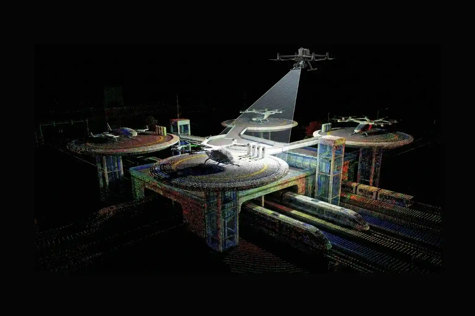
- LiDAR SLAM and Dense Point Clouds: Drones equipped with Light Detection and Ranging (LiDAR) and Simultaneous Localization and Mapping (SLAM) sensors generate 3D “point clouds,” millions of laser-measured coordinates that recreate the city’s geometry. Modern frameworks like FAST-LIO2 tightly integrate Inertial Measurement Unit (IMU) data to ensure accuracy even during rapid maneuvers.
- Visual SLAM and Photogrammetry: While LiDAR captures geometry, visual SLAM uses camera keyframes and feature detection to visually reconstruct the environment. Integrating these datasets produces photo-realistic digital twins that aid in “synthetic vision,” allowing autonomous air taxis to “see” and navigate accurately in poor visibility.
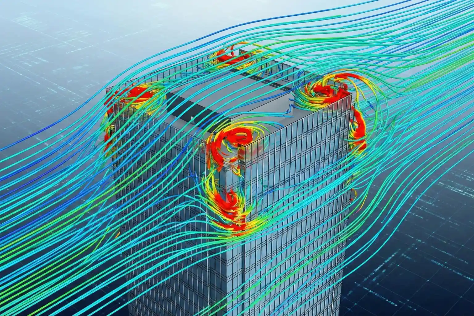
- Atmospheric Modeling: Unlike ground roads, air corridors are dynamic. TII uses advanced simulations to analyze 3D wind flow around skyscrapers and urban terrain. This is critical for defining flight safety boundaries and predicting how micro-currents might affect eVTOL stability.
II. Defining Airspace Volumes and Safeguards
The digital mapping process enables a rigorous vertical layering of the airspace to prevent congestion and accidents:
- Vertical Layering: Current trials are testing specific altitude tiers:
- 500–1,000 feet: A dedicated Safety Buffer Zone kept clear for emergency rerouting or response.
- 1,000–3,000 feet: The Air Taxi Cruise Zone, reserved for high-speed transit of passenger eVTOLs on fixed urban routes.
- Obstacle Evaluation Surfaces (OES): Leveraging GIS capabilities like ArcGIS Aviation, authorities can model Obstacle Limitation Surfaces (OLS). These are 3D volumes that must remain free of intruding objects like cranes or telecom towers. If a structure penetrates these digital boundaries, the system automatically triggers an aeronautical study to adjust the corridor.
III. Real-Time Autonomous Intelligence
The ultimate goal of aerial corridor mapping is to feed data into AI-powered control and communication algorithms. These systems enable real-time decision-making for autonomous aircraft, ensuring they can optimize routes and avoid collisions with other unmanned traffic systems (UTM). This creates a seamless, connected multimodal network that integrates ground, waterways, and skies into a single transportation ecosystem.
Transforming Urban Living and Economics
The drive for aerial corridor mapping is fueled by a desire to fundamentally transform the economic and social fabric of urban environments. As we enter 2026, Advanced Air Mobility (AAM) has transitioned from a demonstrative concept into a “commercially bankable” aviation sub-sector. By establishing these sky-highways, the Middle East and specifically the UAE is positioning itself as the undisputed global reference case for the trillion-dollar low-altitude economy.
I. Unlocking The $87B Logistics Market
The economic potential of a mapped airspace is staggering, with the global AAM market projected to grow from $11.4 billion in 2024 to over $87 billion by 2034.
- Heavy-Lift Cargo Dominance: Cargo drones represent the earliest and most dominant segment of this growth, valued at approximately $1.2 billion in 2024 and expected to reach $6.3 billion by 2034. These systems enable rapid, eco-friendly logistics for high-value, time-sensitive goods, such as medical supplies and perishables across infrastructure-challenged regions.
- Operational Efficiency: By bypassing traditional ground traffic, which cost major urban centers like New York nearly $74 billion in lost productivity annually, AAM offers a scalable solution to congestion.
II. The Premium Mobility Economy
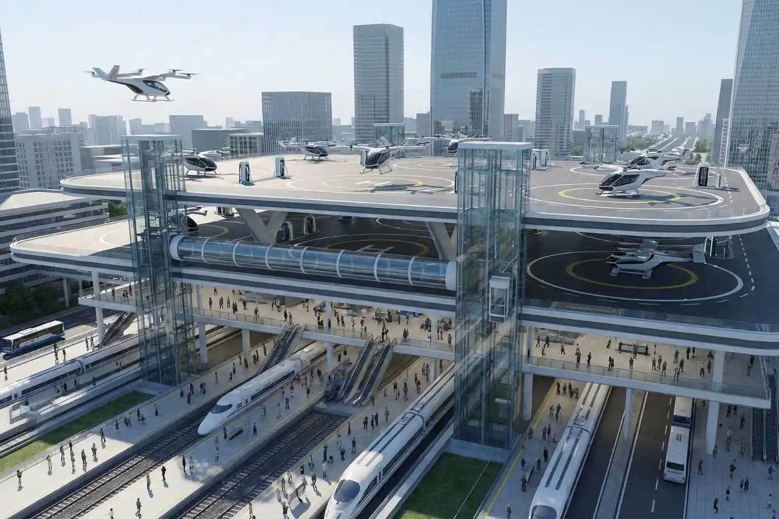
In March 2026, Dubai is set to launch its first operational vertiport, initiating a rapid transit network for air taxis. This “verticalization” of the airspace allows for unprecedented travel speed:
- Time Recovery: eVTOL aircraft, such as the Archer Midnight or Joby models, can condense a 60–90 minute ground commute into a 10–15 minute aerial transit.
- Multimodal Integration: Modern vertiports are designed to integrate seamlessly into the urban landscape, utilizing rooftops, parking structures, and water facilities to connect with existing rail, car, and airport hubs. This multimodal connectivity ensures AAM complements rather than replaces existing infrastructure, facilitating both urban and rural economic growth.
III. Infrastructure Precedent and Asset Value
For developers and giga-project stakeholders, the mapping of aerial corridors creates a new “premium mobility” tier in real estate:
- Digital Infrastructure Investment: By formalizing standards ahead of other global jurisdictions, the UAE reduces uncertainty for manufacturers, insurers, and infrastructure investors.
- Licensing and Employment: The expansion of these networks is expected to result in tens of thousands of new jobs in manufacturing, maintenance, and autonomous operations, stimulating long-term capital formation.
Safety and public acceptance remain the primary catalysts for this desire. The public will only embrace AAM if it feels as safe as traditional transport. High-fidelity data from aerial corridor mapping provides this layer of objective certainty, turning a conceptual “highway in the sky” into an investable, high-density reality.
Claiming Your Space in the Sky
The vertical revolution is here. The UAE has already begun mapping the air corridors that will carry the air taxis and cargo drones of tomorrow. For government entities, urban planners, and industrial operators, the message is clear: the digital infrastructure of the sky is being built right now. To wait is to be left on the ground.
Implementing a strategy for the low-altitude economy requires more than just vision; it requires technical geospatial expertise. You need the data to understand where your assets sit in relation to the emerging sky-highways. This is where aerial corridor mapping becomes your most valuable strategic tool.
Whether you are developing a new smart city or managing a critical industrial corridor, we help you bridge the gap between ground-level operations and the future of the sky with high-resolution mapping, digital twin creation, and GIS integration necessary to operationalize advanced air mobility across the Middle East.
The future of transport is being mapped today, secure your flight paths and claim your place in the new vertical economy. Contact us to begin your journey into the third dimension of industrial efficiency.