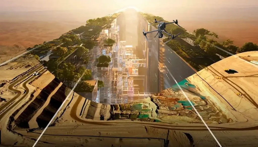
Autonomous Maintenance: How the low altitude economy Will Inspect NEOM’s The Line in 2026
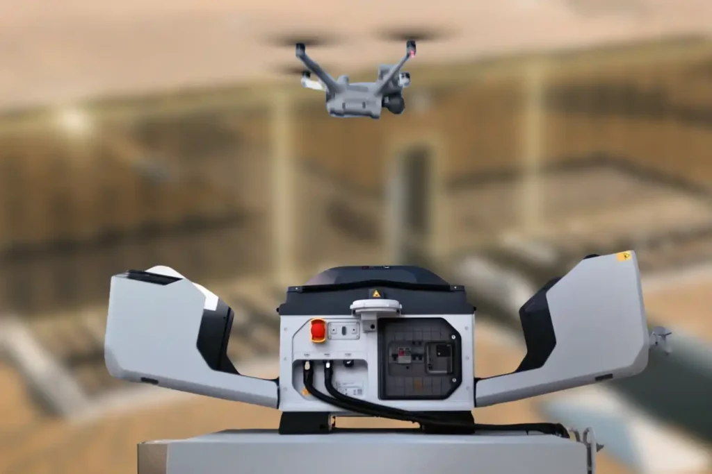
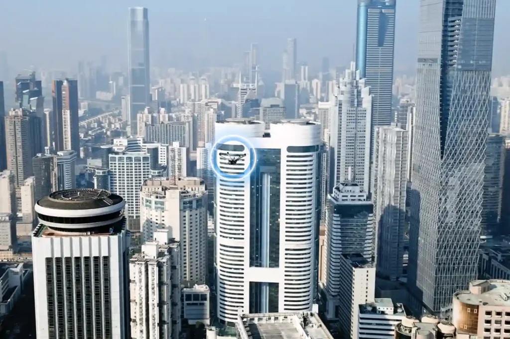
The Density Challenge When we talk about NEOM’s The Line, we are not discussing a standard skyscraper. We are talking about a continuous, 170km-long structure where structure and facilities are bound together in a straight, vertical line. Unlike traditional cities where utilities are spread out horizontally, The Line compresses everything from energy, water, transport, and structural beams into a tight, stacked footprint. This creates a unique maintenance nightmare: overlapped utilities and narrow, vertical corners that are impossible for humans to access safely. In this dense environment, a single pipe failure can cascade into critical electrical systems because they are “gathered” so closely together. Traditional maintenance methods like hanging platforms are too bulky and slow for these confined, high-tech corridors. The solution is not “more people.” It is a new layer of infrastructure. This is the low altitude economy, a dedicated digitized airspace where specialized autonomous robots navigate the tight gaps and vertical shafts to inspect, clean, and maintain the city without human intervention. The Invisible Maintenance Layer In 2026, the maintenance system of The Line will operate as a “Drone Hive,” seamlessly integrated into the building’s spine to handle the complex, gathered infrastructure. I. The Drone Hive (Advanced Docking Stations) Imagine a network of autonomous stations, such as the next-generation DJI Dock 3 (conceptually evolving from the current Dock 2), embedded directly into the utility layers of the megastructure. These compact, weather-proof stations act as home bases. At night or during low-traffic hours, drones automatically deploy to scan the narrow vertical shafts, creating a persistent cycle of monitoring that no human crew could match. II. Navigating the Narrow Corners The Line’s design creates deep, narrow recesses where utilities overlap. Standard drones cannot fly safely in these confined, GPS-denied zones. The solution is the Voliro T. Omnidirectional Flight: Unlike standard drones, the Voliro T uses tiltable rotors to fly in any orientation. It can hover sideways or upside down to navigate the tight corners between a water pipe and a structural beam. Contact Inspection: It can press a probe against a pipe buried deep in a vertical shaft to test for corrosion or sealant failure, ensuring integrity even in the most crowded utility zones. From Inspection to Intelligence The true power of this system isn’t just flight; it’s the ability to untangle the complexity of bound facilities. We are moving from simple inspection to predictive maintenance. III. Predictive Maintenance In a structure where facilities are gathered so tightly, you cannot wait for a leak to happen. The system uses predictive maintenance to analyze the “overlapped” layers of the building. Thermal Scanning: Drones fly the vertical corridors, using thermal sensors to “see” through the layers. They can detect a cooling leak behind a wall panel or an overheating cable tray hidden by a structural beam. The Digital Twin: Every byte of data feeds into NEOM’s Digital Twin. Because the structure and facilities are bound together, the Twin can predict how a vibration in the rail line might affect the plumbing stack next to it. It logs defects, identifies the exact replacement part for that specific narrow corner, and schedules the repair before a failure occurs. IV. Safety & Aesthetics By eliminating bulky external cranes, we preserve the sleek aesthetic of The Line. More importantly, using drones for these narrow, vertical corners removes the risk of sending personnel into confined, high-altitude utility shafts. It turns a high-risk job into a supervised digital workflow. Proving the Concept Today The technology to maintain the vertical cities of the future exists today. It just needs to be scaled. The low altitude economy is not science fiction; it is the operational standard for 2026. You can deploy these autonomous workflows on your current high-rise assets right now to reduce costs and risk and get a FREE 3-month progress monitoring period through talking to our expert.
Precise Prediction: Low Altitude Economy Aerial Data for Digital Twin Infrastructure.

The Urban Data Gap Smart cities like NEOM or Riyadh are not just collections of concrete and glass. They are complex, living systems that breathe, move, and consume energy. Managing such complexity requires real-time intelligence. Yet, many city planners still rely on static ground surveys and outdated maps. They cannot see how a new skyscraper might block airflow or how a road expansion will truly affect traffic until construction is finished. This data gap creates a blind spot that leads to costly errors. The solution lies in the sky. The low altitude economy, the active layer of airspace below 1,000 feet offers a continuous stream of high-resolution aerial data. This data is the fuel that builds the essential digital twin infrastructure for modern urban management. By moving from static maps to dynamic aerial insights, we can predict the future of our cities before we pour the first cubic meter of concrete. Capturing the City in High-Definition To manage a smart city, you must first measure it. Drones act as the sensory layer of the modern metropolis, capturing the physical world in minute detail. I. The Aerial Sensor Network We deploy drones equipped with advanced remote sensing toolkits. These are not just cameras; they are sophisticated instruments. LiDAR sensors shoot laser pulses to measure the exact height of buildings and trees. Thermal cameras detect heat leaks in pipelines and buildings. Multispectral sensors analyze the health of urban green spaces. This network captures the physical city with a level of detail that ground crews simply cannot match. II. 3D City Modeling and Integration This raw data is transformed into precise 3D models. We map every street corner, utility pole, and building facade. This creates the accurate geometric base of your digital twin infrastructure. But data alone is not enough. It must be organized. We build high-resolution maps and GIS databases to store this influx of information. The critical step is integration: ensuring data flows seamlessly from the drone to the database. This creates a “living” map that updates constantly, rather than a static snapshot that expires in a month. Simulating the Future When you have a living digital model, you gain the power of simulation. This is where data turns into decision-making power for city leaders. III. Urban Simulation and Planning Digital twin infrastructure allows planners to test ideas in a virtual world. You can simulate traffic flow during rush hour to test a new intersection design. You can model wind patterns to see how a new tower will affect pedestrian comfort. You can even simulate energy usage across a district to optimize the power grid. This predictive capability removes the guesswork from urban planning. IV. Environmental and Project Management The benefits extend to the environment. Drones monitor air quality sensors and detect urban “heat islands” areas that become dangerously hot. This data helps planners design cooler, healthier parks and living spaces. For the massive giga-projects driving Vision 2030, speed is everything. Aerial surveys track construction progress day by day. Project managers can overlay the digital plan onto the real-world progress to catch errors early. This keeps projects on schedule and saves millions in rework costs. Building the Digital Foundation The transition to a smart city requires a consistent, reliable data pipeline. The low altitude economy provides the speed and cost-efficiency needed to maintain a live digital twin infrastructure. It turns the sky into a digital asset that serves the city on the ground. Don’t plan your city on outdated maps. Partner with Terra Drone Arabia to build your digital foundation. We invite urban developers and government entities to claim a FREE 3-month progress monitoring period on a key development site. Experience the power of live aerial intelligence and start building your future today.
Economy under 1,000 Feet: The Rise of LAE in Smart Cities
The Next Industrial Airspace Layer We often look at the sky and see empty space. However, a quiet revolution is happening just above our heads. This is the rise of the low altitude economy (LAE). This term refers to a new economic and operational domain occupying the airspace below 1,000 feet. It represents the next frontier for industrial efficiency. Global industries are moving fast. They are digitizing their airspace and adopting unmanned systems to perform autonomous inspections. This shift is not just a global trend; it is a critical component of Saudi Arabia’s Vision 2030. The Kingdom is building smart cities and transforming its industrial base. These massive projects require accurate, safe, and continuous aerial operations. Traditional ground methods cannot support this scale. The low altitude economy and industrial applications provide the only viable solution to manage these large-scale assets efficiently. Core Technologies Enabling the LAE To make this new economy work, we need a robust technological foundation. The LAE relies on a stack of advanced systems that ensure safety and predictability. I. The Technological Stack for Safe Operations Unmanned Traffic Management (UTM): We cannot have drones flying blindly. UTM acts like air traffic control for drones. It coordinates airspace, ensures compliance, and prevents collisions. BVLOS Frameworks: Real value comes when drones fly Beyond Visual Line of Sight (BVLOS). This framework establishes safe corridors for drones to operate over long distances, such as along pipelines, utility grids, and coastal zones. Autonomous Drone Stations: Efficiency demands persistence. Autonomous docking stations allow drones to land, charge, and deploy 24/7 without a human pilot on site. Remote Sensing Toolkit: The drone is just the carrier. The value lies in the sensors. We use LiDAR for depth, thermal imaging for heat detection, multispectral sensors for vegetation analysis, and methane detectors for gas leaks. Geospatial Data Infrastructure: All this data must go somewhere. We build high-resolution maps and GIS databases. These form the basis of digital twins, allowing operators to manage physical assets in a digital space. These systems interact seamlessly. They create a predictable and scalable workflow that transforms low altitude economy and industrial applications from a concept into a daily operational reality. Transforming Critical Sectors The application of this technology transforms how we manage the three pillars of modern society: Energy, Utilities, and Urban Development. II. Energy Sector Applications The energy sector demands the highest level of safety and monitoring. Pipeline Integrity: Drones monitor the Right-of-Way (ROW) along vast pipeline networks. They detect leaks and security breaches instantly, protecting the environment and the asset. Flare and Tank Inspection: We replace dangerous manual climbing with drone inspections. Drones perform visual, thermal, and Ultrasonic Thickness (UT) checks on flare stacks and storage tanks. This assesses corrosion and wall health without shutting down operations. Sustainability: Specialized sensors quantify methane and Greenhouse Gas (GHG) emissions. This data helps energy companies meet strict regulatory compliance and sustainability goals. III. Utilities and Power Infrastructure Grid reliability is non-negotiable. Drones ensure the lights stay on. Powerline Inspection: Drones capture high-resolution visual and thermal images of powerlines. LiDAR sensors measure the sag of the lines with centimeter precision. Vegetation Management: Overgrown trees cause outages. Drones analyze vegetation encroachment, allowing utility companies to trim trees only where necessary. Renewable Assets: As the Kingdom adopts green energy, drones inspect solar PV panels for dead cells and wind turbines for blade damage, ensuring maximum energy output. IV. Urban Development and Smart Cities Smart cities like NEOM require smart construction data. Digital Twins: Drones capture data to build 3D city models. These Digital Twins allow planners to simulate traffic, weather, and energy usage before building anything. Progress Tracking: Megaprojects move fast. Aerial surveys track construction progress day by day. This helps project managers catch errors early and keep the project on schedule. Environmental Monitoring: Sensors on drones monitor air quality and heat islands in urban areas. This data helps city planners design cooler, healthier living spaces. Accelerating Efficiency and Adoption The shift to the low altitude economy and industrial applications is not just about technology; it is about business results. V. Why LAE Accelerates Efficiency Cost and Frequency: Automated drones inspect assets more frequently at a lower cost. You can inspect a site daily instead of monthly. Human Safety: We remove humans from high-risk environments. No more climbing towers or entering confined tanks. Real-Time Data: Reports arrive in near real-time. This integration with enterprise systems allows for faster decision-making. National Scale: This technology supports cross-sector interoperability. Data collected for a road project can also help utility companies, supporting national-scale digital initiatives. VI. Pathway to Adoption Governments and industry operators must act now to build this ecosystem. Establish Readiness: Organizations must prepare their technical systems for BVLOS and UTM-aligned operations. Deploy Autonomy: Install autonomous drone stations to enable routine, high-frequency missions. Centralize Data: Build repositories to unify survey and inspection data. Start Pilots: Conduct pilot programs with measurable KPIs to prove the value. Ready to transform your low altitude economy energy, utility, or urban development projects? Let’s realize it through advanced sensing, processing, and data management platforms.
Cutting The 80%: The Efficiency and Safety Gains in Land Surveying.
The foundational work of building Saudi Arabia’s next-generation cities from the coastal developments of Red Sea Global to the vast infrastructure of NEOM begins with a single critical step: land surveying. This core discipline, often taken for granted, is the very first factor dictating a project’s timeline and budget. Yet, the relentless pace and massive scale of Vision 2030 demand an impossible standard that traditional methods simply cannot meet. We have reached a pivotal moment where efficiency must fuse with unprecedented accuracy. The industry’s solution lies in the intelligent adoption of uncrewed aerial systems (UAS), ushering in the new age of digital geospatial capture. As technical leaders in the Middle East, Terra Drone Arabia recognizes that the future of infrastructure hinges on the seamless integration of Drone Photogrammetry and LiDAR, a potent combination that is fundamentally transforming land surveying from a logistical challenge into a competitive advantage. The Technical Engine: How Photogrammetry and LiDAR Deliver Efficiency The “80% Solution” is not a marketing figure; it is a calculated engineering reality driven by the seamless synergy of two advanced sensors. This efficiency gain starts by overcoming the fundamental speed and safety limitations of manual field collection. A. Photogrammetry: The High-Resolution Visual Engine Photogrammetry provides a rich visual context for your project. This process relies on high-resolution aerial imagery taken with massive overlap. Principle of Capture: We mount a highly accurate sensor, such as the Zenmuse P1which features a 45MP full-frame sensor and a mechanical shutter onto a stable, long-endurance platform like the DJI Matrice 400 (M400). The M400 flies precisely, capturing thousands of images in minutes. The Power of Correction: The M400’s integrated RTK (Real-Time Kinematic) system eliminates most Ground Control Points (GCPs). It tags each image with highly precise coordinate data, meaning the resulting 3D models and orthomosaics are geo-referenced with extremely high precision. Efficiency Role: Photogrammetry quickly delivers the accurate, high-detail texture data necessary for digital twin realism and rapid construction monitoring, drastically cutting the time a visual survey would normally take. B. LiDAR: The Penetrating Geometric Scanner (Zenmuse L2) LiDAR is the non-negotiable tool for terrain modeling, specializing in areas where visual methods or ground teams fail. Principle of Penetration: The Zenmuse L2 LiDAR system mounted on the M400 is an active sensor. It emits millions of laser pulses toward the ground. Since a portion of these pulses can penetrate gaps in vegetation or foliage, the L2 effectively maps the bare-earth terrain beneath. Efficiency Role: This superior penetration capability is where the time savings are primarily realized. It eliminates the need for field crews to spend days or weeks clearing vegetation or risking safety in complex, obscured terrain to map the true ground level. It turns a weeks-long logistical nightmare into a single-day flight operation. M400 as the Unified Platform: The long flight endurance of the DJI Matrice 400 (up to 59 minutes) is crucial here, allowing us to cover massive project areas in just a few flights. Furthermore, the M400’s Real-Time Terrain Follow feature ensures the drone maintains a constant distance from the ground even over rugged Saudi topography, guaranteeing data quality across challenging terrain. Quantifying Fidelity: Achieving Survey-Grade Accuracy and Data Fusion The speed of the solution is meaningless if the data quality falls short. This is why the technology must meet, and often exceed, the stringent accuracy standards required for engineering work. A. The Accuracy Mandate: From Pixels to Centimeters For any Land Surveying project to be viable for construction, the data must be provably accurate. Core Data Point: Our drone-based systems, using RTK-corrected photogrammetry and LiDAR, consistently achieve a Ground Sample Distance (GSD) of and a vertical accuracy (RMSE) of less than without relying on excessive manual ground control. This performance level meets the high-fidelity requirements for scale engineering surveys. Hardware Assurance: This precision is guaranteed by the M400’s integration of high-accuracy Inertial Measurement Units (IMU) and the Zenmuse sensors’ TimeSync synchronization, which tags the captured data with microsecond-level position information. B. Data Fusion: The Digital Twin Foundation The ultimate value is realized when the two data streams are merged, a process called data fusion. The Synthesis: We combine the L2’s precise geometric data (the bare-earth terrain model) with the P1’s high-resolution visual texture (the orthomosaic). This fusion creates a single, comprehensive, and auditable reality mesh. Integrated Digital Workflow: This reality mesh is then processed using powerful software like Terra LiDAR Cloud (for automatic point cloud classification and filtering) and seamlessly exported. This final data product is perfectly structured for integration into a client’s BIM (Building Information Modeling) and GIS platforms. This integrated data flow turns a static map into a dynamic, living asset, the foundation for a high-fidelity Digital Twin. The Solution in Action: Safety and Value-Added Land Surveying The efficiency breakthrough directly translates into lower risk, reduced costs, and greater operational intelligence throughout the project. A. Safety and Cost Efficiency Quantified Safety: The reduction in field time eliminates personnel exposure in hazardous areas, such as steep slopes, active machinery zones, and complex utility corridors. This inherently improves the project’s overall safety compliance record. Quantified Cost: faster data collection translates directly into lower labor costs, fewer logistical challenges, and, most importantly, reduces the risk of expensive rework caused by using outdated or geometrically incomplete maps. B. Beyond Topography: Multi-Purpose Survey Data The single act of surveying now captures data for the entire construction lifecycle, making the initial investment a multi-purpose digital asset: Volumetric Analysis: The high-density point clouds enable instant, accurate volumetric analysis for rapid stockpile calculation and cut-and-fill estimations, essential for material logistics and auditing. Corridor Mapping: The LiDAR data excels at precisely mapping transmission corridors, powerlines, and their surrounding vegetation encroachment, providing actionable intelligence for utility and infrastructure clients. This fast, accurate land surveying data is now the indispensable intelligence layer for all modern infrastructure development. Conclusion The revolution in land surveying, driven by the powerful convergence of Drone Photogrammetry and LiDAR, is now a fundamental necessity for the Kingdom’s success. By providing the solution, cutting weeks or months of
Revolutionizing Land Surveying with Drone Photogrammetry and LiDAR Integration
The foundational work of building Saudi Arabia’s next-generation cities from the coastal developments of Red Sea Global to the vast infrastructure of NEOM begins with a single critical step: land surveying. This core discipline, often taken for granted, is the very first factor dictating a project’s timeline and budget. Yet, the relentless pace and massive scale of Vision 2030 demand an impossible standard that traditional methods simply cannot meet. We have reached a pivotal moment where efficiency must fuse with unprecedented accuracy. The industry’s solution lies in the intelligent adoption of uncrewed aerial systems (UAS), ushering in the new age of digital geospatial capture. As technical leaders in the Middle East, Terra Drone Arabia recognizes that the future of infrastructure hinges on the seamless integration of Drone Photogrammetry and LiDAR Integration, a potent combination that is fundamentally transforming land surveying from a logistical challenge into a competitive advantage. The Shift Toward Drone-Based Land Surveying The foundational work of building Saudi Arabia’s next-generation cities from the coastal developments of Red Sea Global to the vast infrastructure of NEOM begins with a single critical step: land surveying. A. The Technical Failure of Legacy Systems For decades, Land Surveying relied on the painstaking work of field teams armed with terrestrial sensors. These conventional methods—principally Total Stations (TS) and network-based GNSS rovers—provided high point-accuracy but were inherently constrained by scale and terrain. For large-scale projects, this legacy system introduces severe technical limitations: Data Resolution and Density Bottleneck: Traditional methods rely on discrete point measurements. A surveyor manually chooses a point to measure, meaning the resulting Digital Terrain Model (DTM) or Digital Surface Model (DSM) is built from a relatively sparse dataset. This inherent lack of data density often proves insufficient for the millimetre-accurate BIM (Building Information Modeling) and complex CAD integration now mandated for modern giga-projects. The limited resolution makes automated clash detection and volumetric analysis key steps in Industry 4.0 workflows difficult or impossible. Geometric Inaccuracy in Obscured Terrain: Ground-based techniques struggle immensely with terrain changes obscured by vegetation, steep slopes, or areas with frequent shadow cover. Total Stations require line-of-sight, forcing multiple, time-consuming setups. For coastal projects requiring high-fidelity cliff or shoreline mapping, this presents a significant geometric challenge and a safety risk. Chronological Data Lag: The intensive manual labor required to cover a 10-square-kilometer site means the project’s foundational topographic data is often compiled over weeks or months. This chronological data lag creates a critical disparity between the existing ground truth and the digital model being used for design and earthworks calculation, leading to inevitable, costly rework downstream. The Time-to-Data Crisis Ultimately, the logistical complexity high manpower, extensive safety planning, and the sheer time required for sequential, manual data capture forces project managers into a six-month waiting period for their foundational topographic base. This systemic lag time is incompatible with the strategic vision of Saudi Arabia, where giga-projects require real-time validation and accelerated decision-making. B. The Geospatial Mandate: Digitalization as a Non-Negotiable The sheer scale of projects like NEOM, Qiddiya, and Red Sea Global—where areas span hundreds of kilometers and deadlines are non-negotiable—demanded a technological solution that could capture and process data instantaneously and comprehensively. The global industry migration to UAS is driven by quantifiable engineering benefits: UAS Platforms for Extended Coverage: Robust enterprise platforms like the DJI Matrice 400 (M400) provide long endurance (up to 59 minutes of flight time) and RTK accuracy, enabling single-flight coverage that compresses months of manual work into hours. The M400 is ideal for lengthy or remote surveying missions due to its extended flight time and range. High-Density Reality Capture: The ability to deploy non-contact sensors either active (LiDAR) or passive (Photogrammetry) collects data at a density measured in millions of points per second. This shift from sparse, manual points to high-density point clouds is the key technical enabler for creating the accurate, living geometric foundation necessary for a true Digital Twin. Mitigation of Safety Risk: By eliminating the need to put personnel on steep embankments, near active machinery, or within hazardous site zones, drone-based land surveying inherently complies with the strict ISO 45001 (Occupational Health and Safety) standards upheld by major clients like Aramco. This urgent demand for fast, centimeter-accurate geospatial data to support BIM workflows, smart city planning, and environmental compliance has rendered traditional methodologies technically obsolete, making drone integration the essential strategy for modern land surveying. Understanding the Technology The transition to drone-based land surveying is defined by two primary technologies: Photogrammetry and LiDAR. While both deliver three-dimensional data, they operate on distinct technical principles, and understanding their complementarity is key to successful project execution. A. Technical Principles and Complementarity The art of effective Land Surveying lies not in choosing one technology, but in mastering the workflow that combines their strengths. Photogrammetry: The High-Resolution Visual Engine Principle: Photogrammetry works by capturing hundreds or thousands of high-resolution, overlapping aerial images of a target area. Processing software then uses complex algorithms to identify common points across these images, triangulating their positions to generate a dense 3D point cloud, a geo-referenced orthomosaic map, and textured 3D models. Accuracy: Modern enterprise systems, such as the DJI Matrice 400 paired with the Zenmuse P1 full-frame camera, use Real-Time Kinematic (RTK) or Post-Processing Kinematic (PPK) corrections. This GPS correction technique eliminates the majority of Ground Control Points (GCPs) and ensures the captured data is geo-referenced with extremely high precision. LiDAR: The Penetrating Geometric Scanner Principle: LiDAR (Light Detection and Ranging) is an active remote sensing technology. The sensor emits millions of laser pulses toward the ground. The time it takes for the pulse to return is measured, enabling the precise calculation of distance. The result is an immensely dense and highly accurate 3D point cloud. Advantage in Complexity: LiDAR excels in environments that defeat photogrammetry namely, areas with dense vegetation, complex utilities, or shadows. The Zenmuse L2 LiDAR, compatible with the M400, features superior penetration capabilities and can detect smaller objects with greater detail. Since a portion of the laser pulses can penetrate gaps in the canopy,
From 6 Months to 3: The Reality Capture Revolution Driving Topographic Survey For Saudi Vision 2030
The scale and speed of construction across Saudi Arabia from NEOM to ROSHN are rewriting the global rules of project management. Under the demanding mandate of Vision 2030, a months-long delay in acquiring foundational data is no longer an option. Project timelines have compressed to the point where the traditional methods used for decades simply fail to keep pace. This urgent demand for speed and accuracy has driven the convergence of Digital Twins and Reality Capture technology to become the new geospatial standard. As a specialized provider in the Middle East, Terra Drone Arabia understands that the first step in building a smart city or giga-project is flawlessly mapping the ground it stands on. This in-depth look explores how drone-based Reality Capture has ignited a revolution in topographic surveying, delivering critical project data not just faster, but with superior quality, and fundamentally setting the stage for the creation of a dynamic digital twin. I. The Bottleneck: Why Traditional Surveying Can’t Deliver Vision 2030 To appreciate the scale of this technological leap, we must first recognize the fundamental limitations of the legacy methods that dominated surveying for decades. Project managers frequently encountered debilitating bottlenecks caused by reliance on ground-based techniques. A. The Six-Month Wait: A Necessary Evil of Legacy Systems Traditional large-scale topographic surveying heavily relies on a painstaking, point-by-point process involving Total Stations and ground-based GPS. For the vast, complex, and often rugged terrains characterizing Saudi giga-projects, this method presents multiple, non-negotiable pain points: Manpower and Time Constraints: The process demands massive field crews and extensive ground access. For an average large-scale project area, the logistical complexity alone meant waiting up to six months to compile the foundational topographic data. Safety Hazards: Deploying personnel into remote, high-altitude, or hazardous coastal environments to collect points creates significant safety risks, leading to costly compliance procedures and delays. Low Data Density: Ground-based techniques capture discrete points. When engineers need to move quickly, this data density can prove insufficient for detailed volumetric calculations or millimeter-accurate BIM integration. The six-month wait for foundational data became a project constraint, a necessary evil that Vision 2030’s accelerated timelines simply cannot afford. This market urgency created the perfect environment for a transformative solution. II. Reality Capture: The Geospatial Engine for Giga-Project Speed The solution to the six-month bottleneck is the aggressive adoption of Reality Capture—a technological shift that moves surveying from a point-measurement exercise to a continuous, ultra-high-density 3D data capture mission. A. The Drone Hardware Supremacy The modern Reality Capture ecosystem relies on multi-payload, heavy-lift platforms built for endurance and high precision, capable of operating reliably in the harsh Middle Eastern climate. Drone LiDAR: Terra Drone Arabia leverages proprietary systems like the Terra LiDAR One to transform data acquisition across the Kingdom. LiDAR sensors unleash millions of laser pulses per second, collecting massive geometric datasets that effectively penetrate vegetation to map bare earth terrain quickly. High-Resolution Photogrammetry: We also utilize best-in-class platforms like the DJI Matrice 400 (M400), which boasts robust all-weather performance and long flight times of up to 59 minutes, ideal for large area mapping. When equipped with the Zenmuse P1 sensor—featuring a 45MP full-frame sensor and a global mechanical shutter—this duo captures centimeter-accurate data for high-resolution 3D models and orthophotos. The M400 with P1 is specifically designed for large-scale surveying and mapping, covering substantial areas in a single flight and is critical for generating the textured, accurate models required for a digital twin. B. Quantifying the Transformation: 50% Time Reduction The efficiency gains are no longer theoretical; they are quantifiable and strategically vital for meeting the Kingdom’s deadlines. The Core Argument: While traditional large-scale topographic surveys take up to six months, an equivalent drone-based LiDAR survey cuts this time by a remarkable 50%, requiring only three months, ensuring giga-projects decisively meet aggressive deadlines. This transformation is achieved through streamlined data collection coupled with immediate data processing capabilities. Furthermore, Photogrammetry complements the LiDAR data by adding texture and visual orthophotos, enriching the captured geometric reality. III. Achieving Survey Grade Accuracy: Data Quality and Compliance The technical professional needs assurance: does this monumental speed sacrifice the necessary survey-grade accuracy? Modern Reality Capture maintains and often surpasses the accuracy standards of traditional methods. A. The Role of Precision Hardware Precision hinges on the quality of the drone’s platform and its advanced navigation systems. Our systems utilize integrated, survey-grade Inertial Measurement Units (IMU) and Global Navigation Satellite Systems (GNSS) to maintain centimeter-level precision. The Zenmuse P1, for example, achieves horizontal accuracy of 3 cm and vertical accuracy of 5 cm without Ground Control Points (GCPs) by utilizing its TimeSync 2.0 system and RTK positioning. This ensures that every one of the millions of captured points is georeferenced with the fidelity demanded by structural engineers and urban planners. B. Auditable Data Processing and Compliance Fast data collection is useless without a framework to process and validate it. This is where the Terra Drone Arabia data pipeline comes in: Quality Control: Platforms like Terra LiDAR Cloud and Terra Mapper process the raw data, performing calibration, classification, and detailed quality checks. This critical step ensures the integrity of the data and provides the auditable documentation necessary for compliance with stringent Saudi regulatory and project mandates. Seamless BIM/GIS Integration: The final reality capture output is delivered in formats perfectly tailored for immediate integration into Building Information Modeling (BIM) and Geospatial Information Systems (GIS) platforms. This instant interoperability allows engineers to immediately use the data for design validation, accelerating the project lifecycle. IV. Beyond Topography: Expanding Reality Capture Value The initial investment in drone-based Reality Capture for topographic surveying is not a one-off cost; it is the acquisition of a digital asset that unlocks ongoing value across the entire project lifecycle. A. Construction Progress and Volumetric Analysis The same high-accuracy data collection process can be applied weekly or even daily, providing unparalleled insight into construction progress. This means: Rapid Stockpile Calculation: Instant, accurate volume analysis of materials, moving beyond inaccurate manual estimates. Cut & Fill Analysis: Precise measurement of earthwork volumes, ensuring
How DJI Dock 3 Saves City Surveillance Budget by 30%

Capturing the Smart City Challenge The growth of modern cities is accelerating at a scale that challenges traditional infrastructure. By 2050, over 68% of the global population is expected to live in urban centers, with cities like Riyadh, Dubai, and Jeddah already experiencing rapid expansion. This growth introduces a complex mix of challenges: Population Density: More people mean higher demand for public safety, efficient mobility, and sustainable living environments. Traffic Congestion: Expanding vehicle use creates bottlenecks, delays emergency response times, and increases CO₂ emissions. Environmental Pressures: Cities must monitor air quality, greenhouse gas emissions, and urban heat islands more closely to comply with sustainability goals such as Saudi Vision 2030. Safety and Security: Public areas, industrial sites, and critical infrastructure face rising risks, requiring real-time monitoring that static systems cannot provide. Traditional monitoring relies on CCTV cameras, ground patrols, and periodic field surveys. Each has critical limitations: CCTV is static. It only covers fixed angles, creating blind spots in complex urban landscapes. Security personnel provide flexibility but require large teams. Covering wide zones demands multiple patrols, often 10 personnel or more for a single district, leading to unsustainable monthly costs. Ground surveys are reactive, offering insights only after the fact. Reports often arrive days late, reducing their value for decision-making. This reliance on traditional systems creates inefficiencies. For example, while one camera or patrol can only monitor a small area at a time, a single autonomous drone from DJI Dock 3 can cover 25 km² from one base and complete a 6 km² flight in just 25 minutes. Beyond coverage, drones deliver real-time intelligence through thermal sensors, night vision, AI object tracking, and live video streaming, making them a superior alternative to static cameras and manual patrols. The financial case is equally strong. Although each security guard is relatively affordable, scaling up to ten or more for a single large zone triples operational costs per month. With DJI Dock 3, cities reduce manpower expenditure by up to 30%, while simultaneously expanding their surveillance capacity and enabling continuous monitoring that traditional methods cannot match. Urban complexity demands new solutions. The shift to smart city drone solutions represents not just an upgrade in technology but a paradigm shift in how cities manage safety, mobility, and sustainability at scale. How DJI Dock 3 Transforms Urban Operations The DJI Dock 3 is designed as more than a launch box. It is a fully autonomous drone-in-a-box solution that delivers continuous, city-wide intelligence with minimal human intervention. Its design addresses the three core requirements of smart city operations: automation, integration, and reliability. Automated Deployment DJI Dock 3 eliminates the need for on-site pilots. With its autonomous takeoff and landing system, drones can be dispatched either on a scheduled basis or triggered on demand by real-time events such as an alarm or emergency call. Each drone is programmed for precision landing within centimeters, guided by RTK positioning and machine vision. The Dock’s rapid-charging system restores 90% battery life in under 30 minutes, ensuring high flight frequency throughout the day. With this capability, a single Dock 3 can maintain persistent aerial coverage, launching multiple flights per day, each surveying up to 6 km² in just 25 minutes. This scale of autonomy allows cities to conduct continuous monitoring without interruption. Integration with FlightHub 2 The true power of Dock 3 lies in its integration with DJI FlightHub 2, a centralized management platform that connects all deployed docks into a unified aerial intelligence network. Fleet Management: FlightHub 2 enables city managers to schedule, monitor, and control dozens of drones across different districts from one dashboard. Data Synchronization: All visual, thermal, and LiDAR data is uploaded to the cloud, where it can be shared across departments such as traffic control, environmental monitoring, and emergency response. Live Streaming: Decision-makers access live video feeds from any drone in the network, giving them instant situational awareness. AI-Powered Insights: FlightHub 2 integrates AI object recognition, anomaly detection, and mapping functions, converting raw data into actionable intelligence for urban planners. Scalability and Reliability The DJI Dock 3 is engineered for long-term, all-weather urban deployment. Weatherproof Design: Rated for IP55, the Dock resists dust and water intrusion, allowing operation in harsh climates such as desert sandstorms or heavy rainfall. Temperature Management: Internal climate control systems regulate temperatures between -35°C to +50°C, ensuring drones remain mission-ready regardless of the environment. Remote Maintenance: Built-in diagnostic tools monitor system health and send alerts for predictive maintenance. This reduces downtime and ensures near-constant availability. Compact Footprint: Dock 3 requires minimal installation space and integrates easily into rooftops, parking lots, or existing infrastructure, enabling cities to deploy dense drone grids where needed. Multi-Sensor Data Collection Every flight from the DJI Dock 3 provides multi-dimensional data tailored to different cities’ needs: RGB Cameras capture high-resolution visuals for infrastructure inspections and public surveillance. Thermal Imaging detects heat anomalies for fire response, energy audits, and perimeter monitoring. Multispectral Sensors provide data for vegetation health, urban greening, and water quality checks. LiDAR Payloads create centimeter-accurate 3D models for flood modeling, slope stability, and urban planning. Use Cases in Smart City Development The real strength of DJI Dock 3 Smart City Applications lies in how its technology addresses multiple urban challenges with precision, speed, and reliability. Each flight becomes a source of actionable intelligence that enables smarter, safer, and more sustainable cities. Public Safety and Surveillance Urban areas face constant security demands. Traditional CCTV cameras cover only fixed angles, leaving blind spots, while human patrols are limited by manpower. Dock 3 drones equipped with RGB and thermal cameras patrol entire districts in a single flight, streaming live video directly to command centers. AI tracking algorithms detect suspicious activity, unattended objects, or unauthorized intrusions in real time. Night vision and thermal imaging ensure effective coverage during nighttime operations, offering visibility up to several hundred meters in low-light conditions. This allows security teams to intervene faster, often within minutes, reducing response times compared to manual patrols or delayed reports. Traffic and Mobility Management Congestion remains one
How Drones Cut Costs by 95% Per Hour in Disaster Management

Drones can play a vital role in rapid emergency response and disaster management. Traditional methods have long struggled with delayed response, limited access, and a lack of real-time situational awareness. These limitations can mean the difference between life and death in high-stakes scenarios such as earthquakes, industrial fires, or large-scale public gatherings. Today, drones are stepping in as agile, intelligent responders. Drones are becoming indispensable tools in building resilient and prepared communities by delivering real-time data, enhancing safety, and reaching dangerous or inaccessible zones. Terra Drone Arabia, backed by global expertise and local insight, is at the forefront of deploying these aerial solutions across Saudi Arabia and the broader Middle East to protect lives and infrastructure. The Unmanned Advantage: Why Drones for Emergency Response? The integration of drones into emergency response workflows is not just a technological upgrade—it is a transformative shift in how crises are assessed, managed, and resolved. In disaster management scenarios, speed, situational awareness, and responder safety are paramount. Drones offer clear advantages across all of these domains, empowering emergency teams to act faster and with greater precision, all while minimizing human risk. Speed and Rapid Deployment: First on the Scene, Always Traditional emergency response methods often involve ground teams navigating debris, traffic, or compromised infrastructure, which can delay arrival by critical minutes or even hours. In contrast, drones can be launched within minutes and fly directly to the site, regardless of terrain or road conditions. With forward flight speeds exceeding 70 km/h and automated flight paths, advanced drones such as the DJI M350 RTK can cover large search areas and transmit real-time visuals back to command centers. Some emergency operations in Saudi Arabia, like during Hajj, have already demonstrated how drones reduce delivery times from over an hour to just six minutes. Even more compelling is drone swarm capability: multiple units can be deployed in coordinated formations to cover vast or complex areas simultaneously, such as collapsed buildings, industrial spill zones, or wildfire-affected landscapes. These features dramatically compress the golden hour for search and rescue, making drones a critical tool for saving lives. Enhanced Safety: Remote Access to Dangerous Environments Drones reduce the need for human entry into unstable or hazardous zones. This is essential in: Post-earthquake structures are prone to collapse Chemical spill zones or industrial gas leaks Flooded or fire-affected areas Equipped with thermal imaging, LiDAR, and gas detection sensors, drones can detect toxic environments, heat anomalies, structural cracks, or radiation without placing a human in harm’s way. Models such as the Flyability Elios 3, which is collision-tolerant and designed for confined space inspection, are especially useful for entering silos, ducts, tunnels, or collapsed infrastructure where traditional responders cannot reach safely. The drone’s beyond visual line of sight (BVLOS) and remote piloting capabilities further ensure that responders maintain complete operational control while staying safely outside of danger zones. Real-time Data and Situational Awareness: Eyes in the Sky, Intelligence on the Ground One of the most critical needs in a disaster response is situational clarity—knowing what’s happening, where it’s happening, and how bad it is. Drones address this need by offering high-resolution aerial imagery, video feeds, and sensor data that can be streamed live to emergency operations centers. Advanced drones can: Capture orthomosaic maps, thermal overlays, and 3D models of disaster zones Provide automated object detection, identifying vehicles, people, or debris using AI Create digital twins of affected areas for analysis and recovery planning Drones using multispectral or LiDAR payloads allow responders to see beneath tree canopies, analyze structural deformation, and understand terrain shifts after landslides or floods. These insights not only support immediate triage but also shape long-term recovery plans. Moreover, when integrated with platforms like Terra Mapper, FlightHub 2, or incident management systems, drone data becomes part of a broader interoperable workflow, fueling decisions around logistics, resource allocation, and public safety alerts. Cost-Effectiveness: Scalable Solutions for Tight Budgets Operating a manned helicopter or deploying ground crews over large areas can cost thousands of dollars per hour and require significant lead time. Drones deliver similar aerial intelligence with cost-effectiveness. Operating a manned helicopter often runs between $650 per mission hour once you add fuel, maintenance, crew, and insurance costs. By comparison, drones deliver equivalent aerial intelligence for as little as $20–25 per hour, including operator time, battery usage, and routine upkeep. Even complex operations, such as a multi-day wildfire assessment, can be completed by drones using automated flight missions and battery hot-swapping systems, eliminating the need for repeated team deployments. Additionally, the same drone hardware can be re-tasked across missions: used for search and rescue today, infrastructure inspection tomorrow, and environmental monitoring the next week. This multi-role capacity ensures higher ROI for civil defense organizations, municipalities, and NGOs. Key Applications of Drones in Emergency Response Building on the unmanned advantage, drone platforms deliver highly specialized capabilities tailored to the rapid emergency response and disaster management environment. Below, we explore three core applications—each underpinned by advanced payloads, data workflows, and operational protocols that maximize effectiveness when every second counts. Search and Rescue Operations Under the umbrella of search and rescue operations, Terra Drone Arabia’s Hajj Medical Delivery Project stands out as a pioneering use case of drone-enabled rapid response. During Hajj 1446, we deployed a dedicated fleet of DJI M350 RTK platforms—each equipped with temperature-controlled, sealed payload compartments—to transport blood bags and critical medical samples across Makkah’s sprawling pilgrimage sites. Leveraging pre-approved flight corridors and real-time UTM integration, these drones bypassed extreme congestion, reducing delivery times from more than two hours via ground vehicles to just six minutes end-to-end. This Hajj project not only demonstrated the life-saving potential of UAVs in large-scale events but also established a replicable blueprint for first-responder logistics, where drones serve as both eyes in the sky and hands on the ground. Damage Assessment and Mapping Post-incident intelligence demands accurate, high-resolution spatial data to guide relief efforts and infrastructure repair. Drones equipped with RTK-enabled LiDAR and photogrammetry payloads generate: 3D point clouds (500+ pts/m² density) for structural modeling—ideal for identifying
UTM Systems: Enhancing Drone Flight Safety and Compliance

UTM Systems are rapidly becoming essential as drones increasingly populate our urban skies. With drones now applicable in many instances, from delivery and inspections to emergency response, their growth presents both opportunities and complex challenges. Among the most pressing are concerns around flight safety, airspace congestion, and regulatory enforcement, especially in cities where drones share airspace with helicopters, aircraft, and critical infrastructure. To address these issues, UTM systems—short for Unmanned Traffic Management—are emerging as the backbone of modern drone governance. These systems offer real-time oversight, geo-fencing, flight authorization, and seamless integration with aviation authorities to ensure that urban drone operations remain safe, compliant, and scalable. What is UTM? Unmanned Traffic Management (UTM) refers to a set of services and technologies designed to manage and monitor unmanned aerial vehicle (UAV) operations, particularly in low-altitude airspace. Unlike traditional Air Traffic Management (ATM) systems that focus on manned aircraft, UTM systems cater specifically to the unique requirements of drones. Key components of UTM include: Airspace Management: Defining and organizing airspace structures to accommodate drone operations. Flight Authorization: Providing permissions for drone flights based on predefined criteria and real-time conditions. Tracking and Surveillance: Monitoring drone positions to ensure safe separation and compliance. Integration with Manned Aviation: Ensuring that drone operations coexist safely with traditional aircraft. These components work in a unified platform to facilitate safe, efficient, and scalable drone operations, especially in densely populated urban areas or critical facilities. Enabling Regulatory Compliance As drone operations scale across commercial, industrial, and government applications, ensuring airspace compliance and regulatory transparency becomes a critical requirement. Unmanned Traffic Management (UTM) systems are designed to serve as the digital backbone that enables regulatory enforcement and safety oversight, automating the governance of unmanned aerial activity across increasingly complex airspaces. Flight Authorization & Geo-fencing Modern UTM platforms enable automated, real-time flight authorization, which reduces the operational bottlenecks associated with manual approvals. Through integration with National Aviation Authority (NAA) systems, operators can request and receive digital clearance for flight missions—sometimes in seconds—based on preconfigured risk profiles and flight zones. Geo-fencing in UTM systems goes beyond static “no-fly zones.” They now incorporate dynamic, adaptive geo-fencing based on airspace status, temporary flight restrictions (TFRs), and real-time NOTAMs (Notices to Airmen). This ensures drones automatically avoid sensitive areas like: Military installations Critical infrastructure Active emergency zones Event airspace (e.g., airports during VVIP movement) These boundaries are enforced at the software level, and in some cases, at the firmware or UAV control layer, making it nearly impossible for non-compliant flights to breach restricted airspace. Audit Trails & Data Logs Regulatory compliance isn’t just about preventing violations, it’s also about ensuring traceability in the event of a flight deviation, near-miss, or unauthorized activity. UTM systems record extensive telemetry, including: Flight paths and altitudes Control input timestamps Communications and mode changes Sensor payload activity logs These logs serve as digital black boxes for drone operations, enabling: Post-incident investigations Operator accountability reviews Insurance and liability assessments Automated reporting for aviation regulators This data also supports organizations in achieving ISO standards compliance, aligning with frameworks like ISO 21384 (UAS operations) and ISO 27001 (information security). Integration with National Aviation Authorities One of the most powerful features of advanced UTM platforms is their ability to integrate with the centralized databases and monitoring dashboards of national aviation authorities (e.g., GACA, FAA, EASA). Through API-based data exchanges and cloud synchronization, UTM platforms can: Share real-time drone positions for traffic deconfliction Report unauthorized or rogue drone activities Enable centralized command-and-control for emergency response Offer automated compliance validation for approved operators This connectivity forms the backbone of cohesive national drone traffic policies, enabling regulators to: Track operator compliance in real time Enforce automatic airspace zoning updates Certify flight log integrity for legal and policy use Ultimately, UTM acts as a regulatory compliance multiplier, empowering both civil aviation authorities and drone operators to work in sync with minimum friction and maximum transparency, paving the way for safe, large-scale BVLOS (Beyond Visual Line of Sight) operations and autonomous drone fleets. Enhancing Flight Safety Flight safety is the foundational pillar of any drone ecosystem, particularly in complex or high-density airspace. Every UAV operation must prioritize collision avoidance, airspace coordination, and emergency preparedness from urban deliveries to critical infrastructure inspections. Unmanned Traffic Management (UTM) systems provide the digital infrastructure that enables this at scale, making airspace safer not only for drones but also for manned aircraft and the people below. Airspace Deconfliction One of the core safety functions of UTM is airspace deconfliction—the ability to predict and proactively prevent potential conflicts between multiple airspace users. By aggregating telemetry from drones, UTM platforms generate a real-time, 3D operational picture that includes: Drone positions and trajectories Assigned air corridors and flight intents Nearby manned aircraft via ADS-B feeds or radar integrations Using geospatial prediction algorithms, UTM systems can assess potential flight path conflicts in advance, calculate Time-To-Loss-of-Separation (TTL), and issue automated resolution advisories such as flight reroutes, altitude adjustments, or emergency holds. This not only ensures safe separation between drones, but also between drones and: Manned aircraft No-fly zones (e.g., airports, military zones) Temporary restricted areas (e.g., fire zones or VVIP events) In the future, as BVLOS operations become more widespread, such dynamic airspace deconfliction will be essential to enable multiple autonomous UAVs to share low-altitude corridors safely. Real-Time Tracking UTM platforms offer persistent real-time tracking of active drone flights through continuous data exchange with UAV onboard systems, either via direct telemetry or network-based identification (e.g., Remote ID). Operators can: View each drone’s live location, heading, speed, altitude, and battery health Detect deviations from authorized flight plans Receive alerts for low-altitude incursions, geo-fence breaches, or proximity to other aircraft For regulators and airspace authorities, this visibility enables centralized oversight across wide geographic regions, essential for coordinating emergency airspace, monitoring operator compliance, or ensuring public safety during urban UAV deployments. Additionally, integration with geo-awareness databases (e.g., NOTAMs, terrain maps, infrastructure overlays) enhances situational context, allowing drones to respond to real-world conditions like terrain elevation, airspace changes, or sudden infrastructure activity (e.g.,
Advance Your Horizons: A Guide to Drone Career Path in 2025

The drone career path is no longer an emerging concept, it’s a well-defined route to high-value roles across industries that rely on precision, efficiency, and innovation. From flare stack inspections in oil & gas to aerial mapping in urban planning, drones have become a central part of modern operations. As we step into 2025, UAV professionals are becoming mission-critical to digital transformation efforts, particularly in regions like Saudi Arabia and the wider MENA area. Structured growth and proper certification aren’t just recommended — they are the foundation of long-term success in this field. The Starting Point: Entry-Level Drone Roles The first step into a UAV career often begins with support roles emphasizing learning by doing. Entry-level operators might assist with visual drone inspections of industrial assets, such as tanks, towers, or pipelines, or manage checklists during missions. These early positions are perfect for building technical awareness and field discipline. Foundational training in photogrammetry and GIS platforms like DJI Terra or ArcGIS Field Maps is commonly introduced at this stage. Additionally, formal certifications such as GACAR Part 107 (in Saudi Arabia) or equivalent national licenses ensure operators understand aviation safety, airspace rules, and mission planning, all essential to industrial compliance. Building Skills Through Certification and Field Experience Once the basics are in place, aspiring drone professionals should actively seek hands-on flight hours. The goal here is to become fluent with different payloads: thermal cameras, multispectral sensors, LiDAR scanners, and high-zoom RGB imaging systems. Industrial use cases, especially in oil & gas, power generation, and infrastructure — demand comfort with automated mission planning, waypoint routing, and live data interpretation. This is also the right time to dive into manufacturer training (like DJI Enterprise programs) or platforms such as Pix4D, FlightHub 2, and Terra Mapper to understand post-processing and mission management tools. In short, growing from operator to asset requires more than flying — it requires confidence in equipment, mission logic, and post-flight deliverables. Specializing in Industry Needs To stand out, professionals should tailor their skills to sector demands. For example, the oil & gas industry often requires familiarity with ultrasonic testing (UT) via drones, or non-destructive testing (NDT) using robotic systems like Voliro T. In agriculture, it’s all about multispectral mapping, NDVI analysis, and precision spraying logic. Each sector comes with its own vocabulary, safety culture, and data expectations. That’s why mid-level drone professionals must invest in contextual expertise: Utilities & power: risk-aware inspections, thermal fault detection Construction: BIM integration, volumetric analysis Renewable energy: panel array surveys, defect localization Urban planning: zoning data overlays, digital twin creation Software proficiencies become more important here too, with CAD, LiDAR data tools, and GIS integration forming the backbone of deliverables. Advancing to Mid-Level Roles With experience and specialization, many UAV professionals move into roles like Lead Operator or Mission Planner. These individuals oversee site planning, lead field teams, and ensure compliance with safety and flight protocols. They also contribute heavily to operational documentation — flight logs, asset reports, and pre/post-inspection forms. At this level, mentoring junior pilots and helping onboard new tech platforms is often part of the role. Professionals who excel here are the ones who balance technical confidence with operational discipline. People who don’t just fly well, but also communicate, document, and manage well. Reaching Leadership: Operations Manager or Technical Lead At the top of the drone career path are roles that go far beyond flight. UAV Operations Managers or Technical Leads manage entire drone programs, overseeing fleets, scheduling missions, setting internal SOPs, and liaising with regulators or enterprise clients. They often work closely with cross-functional teams: AI & data science units (for predictive analytics, anomaly detection) GIS departments (for model integration and spatial workflows) Compliance and safety teams (for audits, risk assessments, and reporting) Leaders in this space often participate in R&D discussions, vet new hardware, and pilot innovation projects, such as integrating digital twins, real-time mapping, or cloud-based remote inspections into day-to-day operations. This is where drone professionals evolve into decision-makers and strategists, shaping the future of industrial UAV adoption. Conclusion In 2025 and beyond, the drone career path is no longer limited to enthusiasts or specialists. It’s a legitimate, scalable career with entry points, vertical mobility, and global demand. The MENA region, especially Saudi Arabia under Vision 2030, is creating enormous opportunities for certified UAV professionals who combine technical excellence with industry understanding. Whether starting as a visual inspector or leading a national drone program, the career path is wide open. For those willing to invest in certification, specialization, and continuous learning, the drone industry isn’t just taking off. It’s landing big careers.