Revolutionizing Land Surveying with Drone Photogrammetry and LiDAR Integration
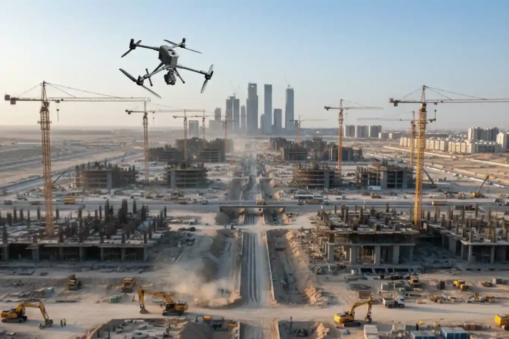
The foundational work of building Saudi Arabia’s next-generation cities from the coastal developments of Red Sea Global to the vast infrastructure of NEOM begins with a single critical step: land surveying. This core discipline, often taken for granted, is the very first factor dictating a project’s timeline and budget. Yet, the relentless pace and massive scale of Vision 2030 demand an impossible standard that traditional methods simply cannot meet. We have reached a pivotal moment where efficiency must fuse with unprecedented accuracy. The industry’s solution lies in the intelligent adoption of uncrewed aerial systems (UAS), ushering in the new age of digital geospatial capture. As technical leaders in the Middle East, Terra Drone Arabia recognizes that the future of infrastructure hinges on the seamless integration of Drone Photogrammetry and LiDAR Integration, a potent combination that is fundamentally transforming land surveying from a logistical challenge into a competitive advantage. The Shift Toward Drone-Based Land Surveying The foundational work of building Saudi Arabia’s next-generation cities from the coastal developments of Red Sea Global to the vast infrastructure of NEOM begins with a single critical step: land surveying. A. The Technical Failure of Legacy Systems For decades, Land Surveying relied on the painstaking work of field teams armed with terrestrial sensors. These conventional methods—principally Total Stations (TS) and network-based GNSS rovers—provided high point-accuracy but were inherently constrained by scale and terrain. For large-scale projects, this legacy system introduces severe technical limitations: Data Resolution and Density Bottleneck: Traditional methods rely on discrete point measurements. A surveyor manually chooses a point to measure, meaning the resulting Digital Terrain Model (DTM) or Digital Surface Model (DSM) is built from a relatively sparse dataset. This inherent lack of data density often proves insufficient for the millimetre-accurate BIM (Building Information Modeling) and complex CAD integration now mandated for modern giga-projects. The limited resolution makes automated clash detection and volumetric analysis key steps in Industry 4.0 workflows difficult or impossible. Geometric Inaccuracy in Obscured Terrain: Ground-based techniques struggle immensely with terrain changes obscured by vegetation, steep slopes, or areas with frequent shadow cover. Total Stations require line-of-sight, forcing multiple, time-consuming setups. For coastal projects requiring high-fidelity cliff or shoreline mapping, this presents a significant geometric challenge and a safety risk. Chronological Data Lag: The intensive manual labor required to cover a 10-square-kilometer site means the project’s foundational topographic data is often compiled over weeks or months. This chronological data lag creates a critical disparity between the existing ground truth and the digital model being used for design and earthworks calculation, leading to inevitable, costly rework downstream. The Time-to-Data Crisis Ultimately, the logistical complexity high manpower, extensive safety planning, and the sheer time required for sequential, manual data capture forces project managers into a six-month waiting period for their foundational topographic base. This systemic lag time is incompatible with the strategic vision of Saudi Arabia, where giga-projects require real-time validation and accelerated decision-making. B. The Geospatial Mandate: Digitalization as a Non-Negotiable The sheer scale of projects like NEOM, Qiddiya, and Red Sea Global—where areas span hundreds of kilometers and deadlines are non-negotiable—demanded a technological solution that could capture and process data instantaneously and comprehensively. The global industry migration to UAS is driven by quantifiable engineering benefits: UAS Platforms for Extended Coverage: Robust enterprise platforms like the DJI Matrice 400 (M400) provide long endurance (up to 59 minutes of flight time) and RTK accuracy, enabling single-flight coverage that compresses months of manual work into hours. The M400 is ideal for lengthy or remote surveying missions due to its extended flight time and range. High-Density Reality Capture: The ability to deploy non-contact sensors either active (LiDAR) or passive (Photogrammetry) collects data at a density measured in millions of points per second. This shift from sparse, manual points to high-density point clouds is the key technical enabler for creating the accurate, living geometric foundation necessary for a true Digital Twin. Mitigation of Safety Risk: By eliminating the need to put personnel on steep embankments, near active machinery, or within hazardous site zones, drone-based land surveying inherently complies with the strict ISO 45001 (Occupational Health and Safety) standards upheld by major clients like Aramco. This urgent demand for fast, centimeter-accurate geospatial data to support BIM workflows, smart city planning, and environmental compliance has rendered traditional methodologies technically obsolete, making drone integration the essential strategy for modern land surveying. Understanding the Technology The transition to drone-based land surveying is defined by two primary technologies: Photogrammetry and LiDAR. While both deliver three-dimensional data, they operate on distinct technical principles, and understanding their complementarity is key to successful project execution. A. Technical Principles and Complementarity The art of effective Land Surveying lies not in choosing one technology, but in mastering the workflow that combines their strengths. Photogrammetry: The High-Resolution Visual Engine Principle: Photogrammetry works by capturing hundreds or thousands of high-resolution, overlapping aerial images of a target area. Processing software then uses complex algorithms to identify common points across these images, triangulating their positions to generate a dense 3D point cloud, a geo-referenced orthomosaic map, and textured 3D models. Accuracy: Modern enterprise systems, such as the DJI Matrice 400 paired with the Zenmuse P1 full-frame camera, use Real-Time Kinematic (RTK) or Post-Processing Kinematic (PPK) corrections. This GPS correction technique eliminates the majority of Ground Control Points (GCPs) and ensures the captured data is geo-referenced with extremely high precision. LiDAR: The Penetrating Geometric Scanner Principle: LiDAR (Light Detection and Ranging) is an active remote sensing technology. The sensor emits millions of laser pulses toward the ground. The time it takes for the pulse to return is measured, enabling the precise calculation of distance. The result is an immensely dense and highly accurate 3D point cloud. Advantage in Complexity: LiDAR excels in environments that defeat photogrammetry namely, areas with dense vegetation, complex utilities, or shadows. The Zenmuse L2 LiDAR, compatible with the M400, features superior penetration capabilities and can detect smaller objects with greater detail. Since a portion of the laser pulses can penetrate gaps in the canopy,
From 6 Months to 3: The Reality Capture Revolution Driving Topographic Survey For Saudi Vision 2030
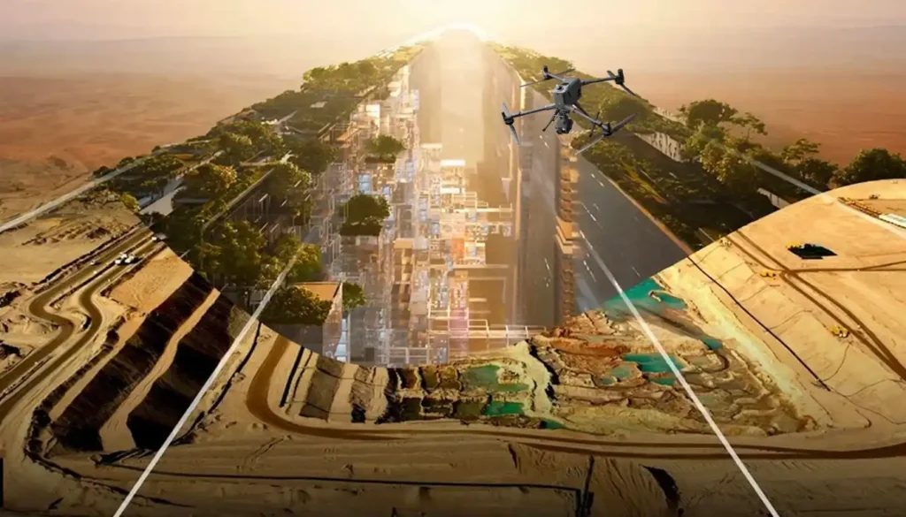
The scale and speed of construction across Saudi Arabia from NEOM to ROSHN are rewriting the global rules of project management. Under the demanding mandate of Vision 2030, a months-long delay in acquiring foundational data is no longer an option. Project timelines have compressed to the point where the traditional methods used for decades simply fail to keep pace. This urgent demand for speed and accuracy has driven the convergence of Digital Twins and Reality Capture technology to become the new geospatial standard. As a specialized provider in the Middle East, Terra Drone Arabia understands that the first step in building a smart city or giga-project is flawlessly mapping the ground it stands on. This in-depth look explores how drone-based Reality Capture has ignited a revolution in topographic surveying, delivering critical project data not just faster, but with superior quality, and fundamentally setting the stage for the creation of a dynamic digital twin. I. The Bottleneck: Why Traditional Surveying Can’t Deliver Vision 2030 To appreciate the scale of this technological leap, we must first recognize the fundamental limitations of the legacy methods that dominated surveying for decades. Project managers frequently encountered debilitating bottlenecks caused by reliance on ground-based techniques. A. The Six-Month Wait: A Necessary Evil of Legacy Systems Traditional large-scale topographic surveying heavily relies on a painstaking, point-by-point process involving Total Stations and ground-based GPS. For the vast, complex, and often rugged terrains characterizing Saudi giga-projects, this method presents multiple, non-negotiable pain points: Manpower and Time Constraints: The process demands massive field crews and extensive ground access. For an average large-scale project area, the logistical complexity alone meant waiting up to six months to compile the foundational topographic data. Safety Hazards: Deploying personnel into remote, high-altitude, or hazardous coastal environments to collect points creates significant safety risks, leading to costly compliance procedures and delays. Low Data Density: Ground-based techniques capture discrete points. When engineers need to move quickly, this data density can prove insufficient for detailed volumetric calculations or millimeter-accurate BIM integration. The six-month wait for foundational data became a project constraint, a necessary evil that Vision 2030’s accelerated timelines simply cannot afford. This market urgency created the perfect environment for a transformative solution. II. Reality Capture: The Geospatial Engine for Giga-Project Speed The solution to the six-month bottleneck is the aggressive adoption of Reality Capture—a technological shift that moves surveying from a point-measurement exercise to a continuous, ultra-high-density 3D data capture mission. A. The Drone Hardware Supremacy The modern Reality Capture ecosystem relies on multi-payload, heavy-lift platforms built for endurance and high precision, capable of operating reliably in the harsh Middle Eastern climate. Drone LiDAR: Terra Drone Arabia leverages proprietary systems like the Terra LiDAR One to transform data acquisition across the Kingdom. LiDAR sensors unleash millions of laser pulses per second, collecting massive geometric datasets that effectively penetrate vegetation to map bare earth terrain quickly. High-Resolution Photogrammetry: We also utilize best-in-class platforms like the DJI Matrice 400 (M400), which boasts robust all-weather performance and long flight times of up to 59 minutes, ideal for large area mapping. When equipped with the Zenmuse P1 sensor—featuring a 45MP full-frame sensor and a global mechanical shutter—this duo captures centimeter-accurate data for high-resolution 3D models and orthophotos. The M400 with P1 is specifically designed for large-scale surveying and mapping, covering substantial areas in a single flight and is critical for generating the textured, accurate models required for a digital twin. B. Quantifying the Transformation: 50% Time Reduction The efficiency gains are no longer theoretical; they are quantifiable and strategically vital for meeting the Kingdom’s deadlines. The Core Argument: While traditional large-scale topographic surveys take up to six months, an equivalent drone-based LiDAR survey cuts this time by a remarkable 50%, requiring only three months, ensuring giga-projects decisively meet aggressive deadlines. This transformation is achieved through streamlined data collection coupled with immediate data processing capabilities. Furthermore, Photogrammetry complements the LiDAR data by adding texture and visual orthophotos, enriching the captured geometric reality. III. Achieving Survey Grade Accuracy: Data Quality and Compliance The technical professional needs assurance: does this monumental speed sacrifice the necessary survey-grade accuracy? Modern Reality Capture maintains and often surpasses the accuracy standards of traditional methods. A. The Role of Precision Hardware Precision hinges on the quality of the drone’s platform and its advanced navigation systems. Our systems utilize integrated, survey-grade Inertial Measurement Units (IMU) and Global Navigation Satellite Systems (GNSS) to maintain centimeter-level precision. The Zenmuse P1, for example, achieves horizontal accuracy of 3 cm and vertical accuracy of 5 cm without Ground Control Points (GCPs) by utilizing its TimeSync 2.0 system and RTK positioning. This ensures that every one of the millions of captured points is georeferenced with the fidelity demanded by structural engineers and urban planners. B. Auditable Data Processing and Compliance Fast data collection is useless without a framework to process and validate it. This is where the Terra Drone Arabia data pipeline comes in: Quality Control: Platforms like Terra LiDAR Cloud and Terra Mapper process the raw data, performing calibration, classification, and detailed quality checks. This critical step ensures the integrity of the data and provides the auditable documentation necessary for compliance with stringent Saudi regulatory and project mandates. Seamless BIM/GIS Integration: The final reality capture output is delivered in formats perfectly tailored for immediate integration into Building Information Modeling (BIM) and Geospatial Information Systems (GIS) platforms. This instant interoperability allows engineers to immediately use the data for design validation, accelerating the project lifecycle. IV. Beyond Topography: Expanding Reality Capture Value The initial investment in drone-based Reality Capture for topographic surveying is not a one-off cost; it is the acquisition of a digital asset that unlocks ongoing value across the entire project lifecycle. A. Construction Progress and Volumetric Analysis The same high-accuracy data collection process can be applied weekly or even daily, providing unparalleled insight into construction progress. This means: Rapid Stockpile Calculation: Instant, accurate volume analysis of materials, moving beyond inaccurate manual estimates. Cut & Fill Analysis: Precise measurement of earthwork volumes, ensuring