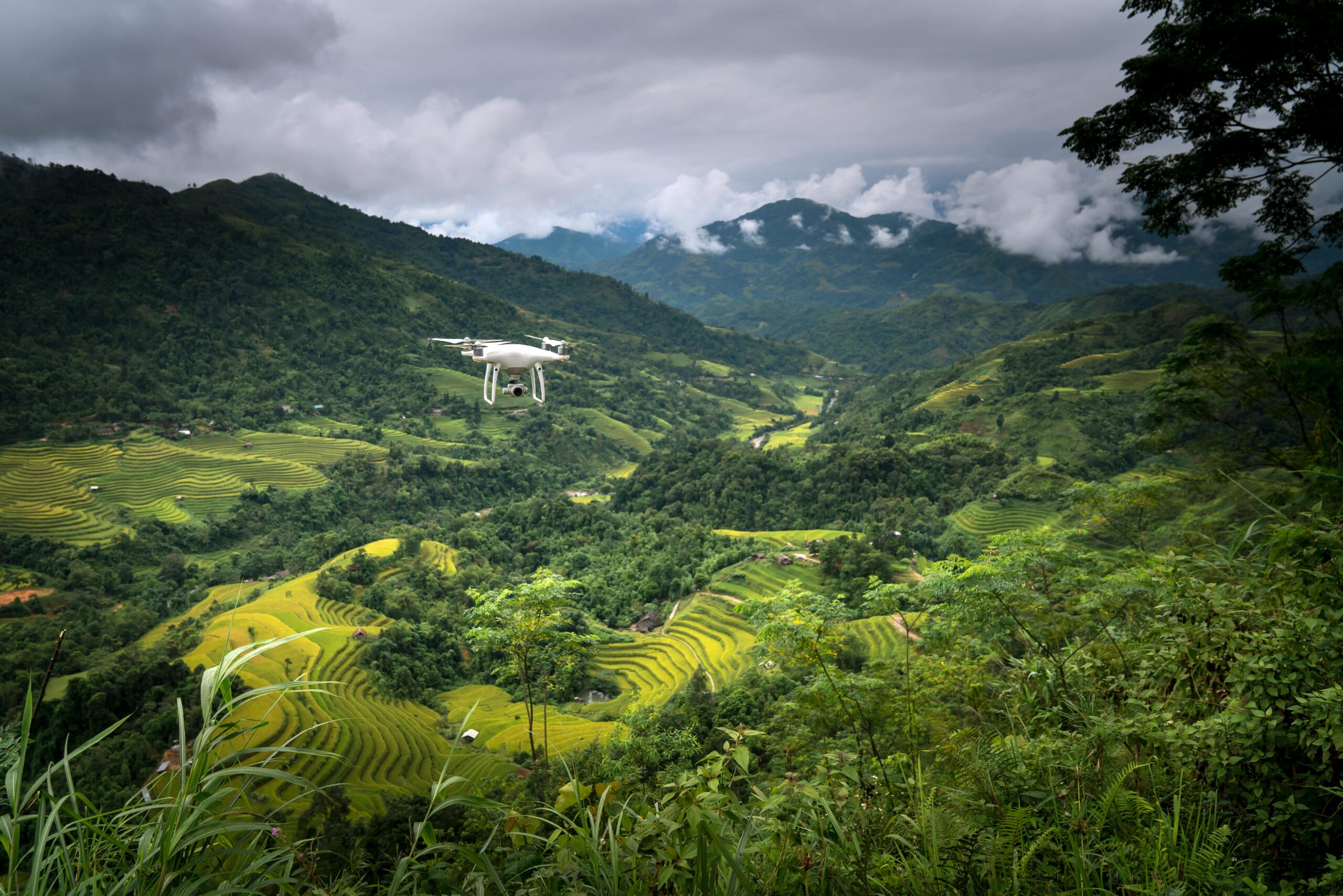
Drones for surveying are one of the signs of the advent of drone technology have marked a significant milestone in the evolution of surveying and mapping practices. With the ability to cover vast areas in a fraction of the time it takes traditional methods, drones, or unmanned aerial vehicles (UAVs), are not just an innovation; they’re a revolution in the field. This comprehensive guide delves into how drones for survey purposes are reshaping the landscape of geospatial data collection, offering insights into its techniques, benefits, and the potential future of drone surveying.
The Impact and Efficiency of Drones for Survey and Mapping
The Evolution of Surveying and Mapping Techniques
Surveying and mapping have been fundamental to human development, from delineating land for agricultural purposes to planning the layout of vast urban cities. Traditional surveying methods have relied heavily on manual labor and ground-based equipment, a process both time-consuming and labor-intensive. The transition to aerial photography marked the first significant leap in overcoming these limitations, yet it was the introduction of drones that truly catapulted the field into a new era.
Drones have introduced a level of flexibility, efficiency, and accuracy previously unimaginable. Drone surveying techniques leverage advanced sensors and imaging technologies to capture high-resolution data from above, providing a bird’s eye view that is both comprehensive and detailed.
Why Drones are Game-Changers in Surveying and Mapping
The application of drones for survey work has become a game-changer for several reasons. Firstly, the cost-effectiveness of drone operations allows for frequent and extensive surveys without the significant expenses associated with manned aircraft or satellite imaging. This accessibility means that even smaller projects can benefit from high-quality aerial data.
Moreover, drones can access areas that are difficult, dangerous, or even impossible for humans to reach. Whether it’s surveying a remote wilderness, monitoring an active volcano, or inspecting a hazardous construction site, drones can do so safely and efficiently. The speed at which drones can cover ground, combined with the ease of deployment, significantly reduces the time required for data collection, enabling real-time decision-making and rapid responses to changing conditions.
The benefits of drone mapping also extend to the quality of data collected. With the capacity to fly at lower altitudes than manned aircraft, drones capture ultra-high-resolution images that provide detailed insights into the surveyed area. This precision supports a wide range of applications, from topographic surveys and environmental monitoring to urban planning and disaster management.
The Impact of Drones on Surveying and Mapping
The impact of drones on the surveying and mapping industry is profound. By democratizing access to high-quality geospatial data, drones are not just enhancing existing practices; they’re enabling new possibilities. From small-scale construction projects to large-scale environmental conservation efforts, drone technology is providing value across the board.
However, the revolution goes beyond just technical capabilities. The efficiency and safety benefits of using drones for surveying have led to a cultural shift within the industry. Professionals are now more willing to embrace new technologies, leading to innovation and advancements in geospatial data analysis and application.
The integration of drone technology into surveying and mapping represents a leap forward in how we understand and interact with the world around us. As we continue to explore the benefits and capabilities of drones, their role in shaping the future of surveying and mapping is undeniable.
Key Applications of Drone for Surveying and Mapping
The versatility of drones for survey applications is truly remarkable, spanning across multiple sectors. Each application not only showcases the adaptability of drone technology but also its potential to significantly enhance operational efficiency and data accuracy.

Drones for surveying are one of the signs of the advent of drone technology have marked a significant milestone in the evolution of surveying and mapping practices. With the ability to cover vast areas in a fraction of the time it takes traditional methods, drones, or unmanned aerial vehicles (UAVs), are not just an innovation; they’re a revolution in the field. This comprehensive guide delves into how drones for survey purposes are reshaping the landscape of geospatial data collection, offering insights into its techniques, benefits, and the potential future of drone surveying.
The Impact and Efficiency of Drones for Survey and Mapping
The Evolution of Surveying and Mapping Techniques
Surveying and mapping have been fundamental to human development, from delineating land for agricultural purposes to planning the layout of vast urban cities. Traditional surveying methods have relied heavily on manual labor and ground-based equipment, a process both time-consuming and labor-intensive. The transition to aerial photography marked the first significant leap in overcoming these limitations, yet it was the introduction of drones that truly catapulted the field into a new era.
Drones have introduced a level of flexibility, efficiency, and accuracy previously unimaginable. Drone surveying techniques leverage advanced sensors and imaging technologies to capture high-resolution data from above, providing a bird’s eye view that is both comprehensive and detailed.
Why Drones are Game-Changers in Surveying and Mapping
The application of drones for survey work has become a game-changer for several reasons. Firstly, the cost-effectiveness of drone operations allows for frequent and extensive surveys without the significant expenses associated with manned aircraft or satellite imaging. This accessibility means that even smaller projects can benefit from high-quality aerial data.
Moreover, drones can access areas that are difficult, dangerous, or even impossible for humans to reach. Whether it’s surveying a remote wilderness, monitoring an active volcano, or inspecting a hazardous construction site, drones can do so safely and efficiently. The speed at which drones can cover ground, combined with the ease of deployment, significantly reduces the time required for data collection, enabling real-time decision-making and rapid responses to changing conditions.
The benefits of drone mapping also extend to the quality of data collected. With the capacity to fly at lower altitudes than manned aircraft, drones capture ultra-high-resolution images that provide detailed insights into the surveyed area. This precision supports a wide range of applications, from topographic surveys and environmental monitoring to urban planning and disaster management.
The Impact of Drones for Surveying and Mapping
The impact of drones on the surveying and mapping industry is profound. By democratizing access to high-quality geospatial data, drones are not just enhancing existing practices; they’re enabling new possibilities. From small-scale construction projects to large-scale environmental conservation efforts, drone technology is providing value across the board.
However, the revolution goes beyond just technical capabilities. The efficiency and safety benefits of using drones for surveying have led to a cultural shift within the industry. Professionals are now more willing to embrace new technologies, leading to innovation and advancements in geospatial data analysis and application.
The integration of drone technology into surveying and mapping represents a leap forward in how we understand and interact with the world around us. As we continue to explore the benefits and capabilities of drones, their role in shaping the future of surveying and mapping is undeniable.
Key Applications of Drone Technology in Surveying and Mapping
The versatility of drones for survey applications is truly remarkable, spanning across multiple sectors. Each application not only showcases the adaptability of drone technology but also its potential to significantly enhance operational efficiency and data accuracy.
Agriculture: Precision Farming Takes Flight
In agriculture, drones are revolutionizing the way farmers manage their crops. Through high-resolution imagery, drones provide detailed insights into crop health, soil conditions, and moisture levels. This data is invaluable for precision farming practices, enabling farmers to make informed decisions about irrigation, planting, and pest management. Drone surveying techniques in agriculture are not just about improving yields; they’re about optimizing resource use and minimizing environmental impact.
Construction: Building the Future with Enhanced Precision
The construction industry benefits immensely from drone technology, especially in site planning and monitoring. Drones offer a comprehensive overview of construction sites, tracking progress, and identifying potential issues before they become costly problems. The ability to create 3D models of construction sites from drone-captured data helps in accurate planning and effective communication among stakeholders, ensuring projects stay on schedule and within budget.
See how drones monitor construction progress: read here
Environmental Monitoring: A Bird’s Eye View on Conservation
Drones play a crucial role in environmental conservation and monitoring. They are used for mapping deforestation, monitoring wildlife populations, and assessing the impact of natural disasters. The aerial perspective provided by drones is pivotal in understanding and managing environmental changes, offering a tool for researchers and conservationists to monitor ecosystems accurately and over time.
Urban Planning: Shaping Cities with Data
In urban planning, drones offer a dynamic tool for mapping and development. The detailed aerial imagery helps in land use planning, disaster management, and infrastructure development. Urban planners can utilize drone-collected data to design more efficient, sustainable, and livable urban environments, demonstrating the benefits of drone mapping in shaping future cities.
Enhancing Data Quality and Accessibility
One of the most significant impacts of drone technology in analyzing and mapping is the enhancement of data quality and accessibility. Drones provide data with unparalleled accuracy and detail, enabling surveyors and analysts to make more informed decisions.
High-Resolution Data for Informed Decision Making
The high-resolution imagery and 3D models generated by drones offer a level of detail that is often unattainable with traditional analyzing methods. This data richness allows for more precise measurements, better risk assessment, and improved resource management, underscoring the advancements in drone surveying technology.
Accessibility and Frequency: Keeping Data Up-to-Date
Drones not only improve the quality of data but also its accessibility. They can be deployed quickly and frequently, providing up-to-date information that is crucial for dynamic projects and environments. This capability is particularly beneficial in rapidly changing situations, such as during construction projects or after natural disasters, where timely data is essential for effective response and recovery efforts.
Overcoming Challenges with Drone Surveying and Mapping
Despite the many benefits, the use of drones for survey operations faces its share of challenges. Regulatory hurdles, privacy concerns, and technical limitations are among the primary obstacles. However, the industry’s response to these challenges showcases its commitment to responsible and effective drone use.
Navigating Regulatory Landscapes
The regulatory environment for drone operations varies significantly across jurisdictions, often posing a challenge to widespread adoption. Compliance with airspace regulations, obtaining the necessary permits, and adhering to privacy laws require diligent navigation. Advancements in drone analyzing have led to better-informed regulatory frameworks, balancing the benefits of drone technology with safety and privacy concerns.
Privacy and Ethical Considerations
Privacy concerns arise when drones capture images or data in sensitive areas. The industry has responded by implementing strict operational guidelines that respect privacy and minimize intrusions. Ethical use policies and data management protocols ensure that drone operations are conducted with the utmost respect for individual privacy and data protection.
Technical Limitations and Solutions
While drone technology has advanced rapidly, technical limitations such as battery life, payload capacity, and adverse weather operations still pose challenges. Ongoing research and development are dedicated to overcoming these limitations, with innovations in battery technology, lightweight materials, and weather-resistant designs enhancing drone capabilities and operational efficiency.
The Future of Drone Technology in Surveying and Mapping
The future of drone technology in the realm of surveying and mapping is incredibly promising, with emerging trends and technologies poised to further revolutionize the field.

Integration with AI and Machine Learning
Integrating artificial intelligence (AI) and machine learning with drone technology is set to unlock new levels of data analysis and interpretation. AI algorithms can analyze drone-captured imagery to identify patterns, changes, and anomalies, providing insights faster and with greater accuracy. This synergy between drones and AI enhances decision-making processes and operational efficiencies across various applications.
Beyond Visual Line of Sight (BVLOS) Operations
Advancements in communication and navigation technologies are paving the way for beyond-visual line of sight (BVLOS) drone operations. BVLOS capabilities will enable drones to cover larger areas without the need for direct visual supervision, significantly expanding their potential for overseeing and mapping tasks. Regulatory bodies are beginning to recognize the potential of BVLOS operations, with pilot programs and new regulations in development to ensure safe and effective implementation.
Enhanced Precision with RTK and PPK
Real-time kinematic (RTK) and post-processed kinematic (PPK) positioning technologies are enhancing the precision of drone surveys. By providing highly accurate location data, RTK and PPK enable drones to achieve near-survey-grade accuracy, further closing the gap between traditional and drone surveying methods.
Drones and the Future of Geospatial Data
The role of drones in surveying and mapping is not just about the technology itself but about how it integrates into and enhances our understanding of the physical world. As we move forward, the potential applications of drone technology continue to grow, driven by both technological advancements and a deeper appreciation for the value of accurate, timely geospatial data.

Drones for Surveying and Mapping in Smart Cities: Shaping the Urban Future
One of the most promising areas for drone integration is in the development and management of smart cities. Drones offer a dynamic tool for urban planners and authorities, providing critical data for traffic management, infrastructure maintenance, and emergency response planning. As cities continue to grow and evolve, drone technology will play a crucial role in ensuring they do so sustainably and efficiently.
Environmental and Disaster Management: A Drone’s Eye View
In the face of climate change and natural disasters, drones offer a powerful tool for environmental monitoring and disaster management. By providing real-time data on wildfires, floods, and other natural events, drones can help mitigate their impact and guide effective response strategies. Moreover, drones facilitate long-term environmental monitoring, contributing valuable data to the study of climate change and its effects on our planet.
The Role of Drones in Global Development and Humanitarian Efforts
Beyond their commercial and environmental applications, drones hold significant promise for global development and humanitarian efforts. In remote or inaccessible areas, drones can be used to map resources, monitor crop health, and even deliver medical supplies. This capability to reach the unreachable opens new avenues for development work and emergency aid, underscoring the versatile and impactful nature of drone technology.
Embracing the Future of Drone Technology
As we stand on the cusp of a new era in surveying and mapping, it’s clear that drone technology will continue to play a pivotal role. The integration of drones into these fields is not just about the technology itself but about how it can be used to better understand and interact with the world around us. Embracing this future means continuing to innovate, pushing the boundaries of what’s possible, and ensuring that drone technology is used responsibly and ethically.
The Importance of Education and Collaboration
To fully realize the potential of drone technology, education and collaboration among stakeholders—governments, industries, academia, and communities—are essential. By fostering an environment of learning and cooperation, we can ensure that the benefits of drone technology are accessible to all and that its applications are guided by principles of sustainability and equity.
Conclusion
The revolution of surveying and mapping by drone technology is just beginning. As we look to the future, the possibilities are as vast as the landscapes these drones traverse. From enhancing the efficiency and accuracy of data collection to opening new frontiers in urban planning, environmental conservation, and global development, drones are not merely changing the way we see the world—they’re shaping the future of how we live in it.
As we continue to explore and expand the capabilities of drones for survey operations, the journey ahead is filled with potential and promise. The revolution in surveying and mapping is underway, and it’s clear that the sky is not the limit—it’s just the beginning.
To understand further how drones can transform the survey and mapping practice in your company, you can book a free consultancy with our expert at the link below:

