The Corrosion Inspection Challenge
Corrosion is the silent and relentless enemy of metal assets—it remains the leading cause of unplanned shutdowns, containment failures, and devastating safety risks across the oil & gas, petrochemical, and heavy industrial sectors. In the demanding environments of the MENA region, assets like storage tanks, pipelines, and flare stacks face extreme pressure and must maintain peak structural integrity.
The conventional methods for fighting corrosion are simply no longer good enough.
- Scaffolding and Time: Traditional inspections require extensive, costly scaffolding or rope access, shutting down operations for days or weeks. This severely impacts productivity.
- Safety Risks: Inspectors must enter hazardous confined spaces or climb hundreds of meters above the ground, exposing them to significant dangers.
- Manual Data: Manual Ultrasonic Thickness (UT) checks are subjective, slow, and often provide data that is difficult to trace and integrate into digital asset management systems.
Industry urgently needs a safer, faster, and more data-rich way to assess asset health. The solution is the convergence of aerial technology and specialized testing: corrosion inspection with drone-based visual and UT systems.
Integrating Visual and Ultrasonic Thickness (UT) Drones
The future of asset integrity lies in non-contact aerial access combined with contact-based measurement precision. Drone technology now provides a complete, two-part inspection solution.
I. High-Resolution Visual Inspection
Visual drones start the process by quickly capturing comprehensive data on the asset’s exterior.
- Complete Coverage: Drones fly precise, automated paths around tanks, pipelines, and stacks, collecting high-resolution imagery. This imagery builds a precise 3D model (photogrammetry) of the asset.
- Defect Mapping: Specialized cameras detect and map all surface defects, such as paint degradation, coating loss, signs of external corrosion, and cracking. This creates a digital record showing the location and size of every visible fault.
- Efficiency Metric: By eliminating the manual setup time, drone technology can reduce the time required for complex tank or flare stack inspections by up to 95% compared to traditional scaffolding or rope access methods, delivering immediate time and cost savings.
II. Drone Equipment Solution: The Hardware Behind the Data
Terra Drone Arabia delivers advanced results by operating both proprietary solutions and specialized hardware designed for harsh industrial environments. Our fleet is purpose-built to execute both visual and contact-based NDT with exceptional stability and accuracy.
- Visual Platforms: For initial high-resolution assessment and long-range mapping, our solutions rely on robust, enterprise-grade multirotor platforms. These systems carry high-resolution cameras and thermal sensors, enabling fast, safe visual coverage of vast industrial footprints.
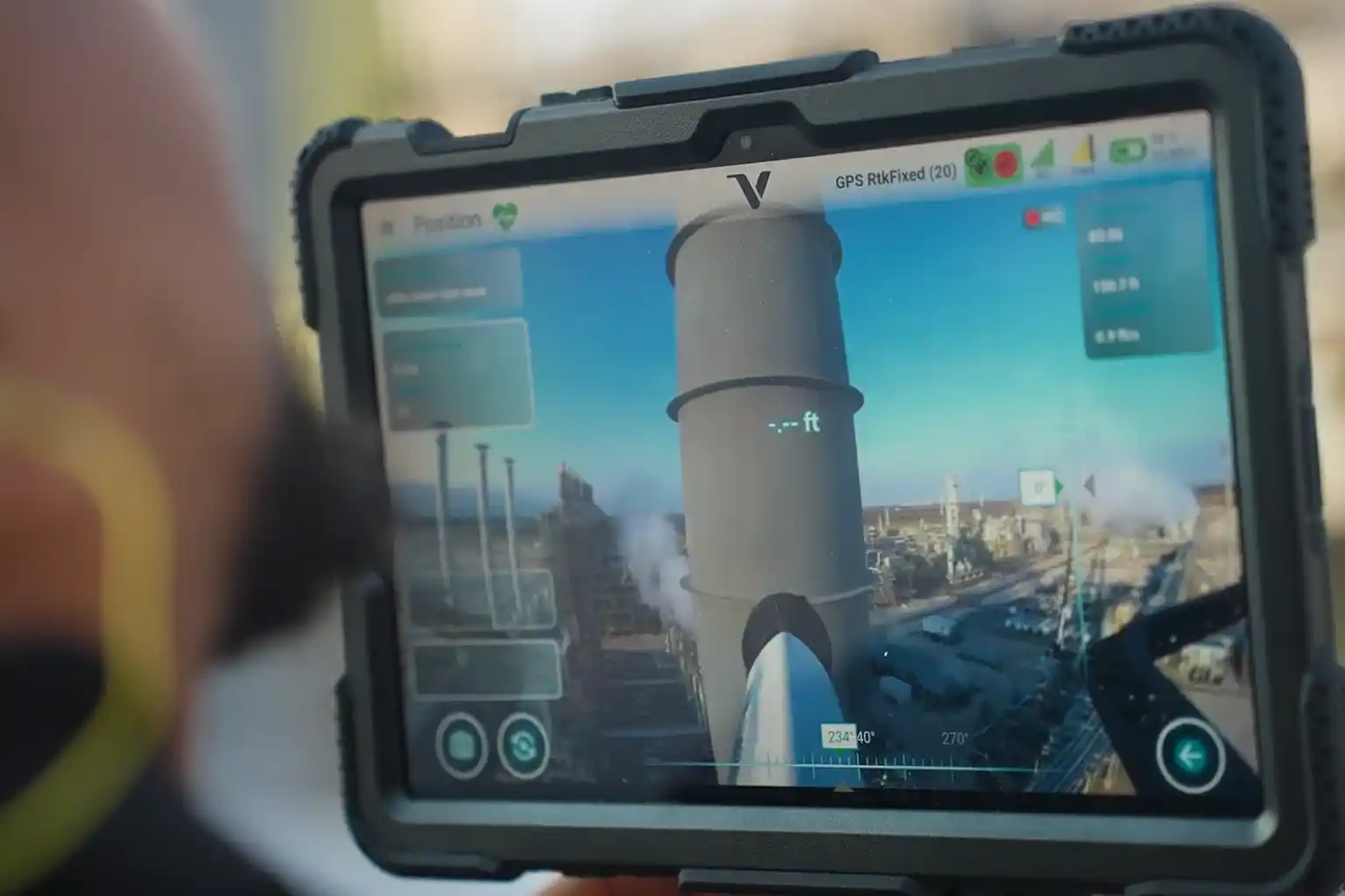
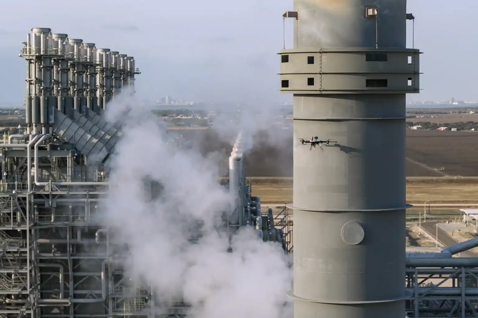
- Voliro T for Contact NDT: For vital external contact-based measurements, we deploy the Voliro T drone. This aerial robotic platform is uniquely engineered with omnidirectional flight capabilities and tiltable rotors. This allows the drone to apply stable, measurable force to vertical or overhead metal surfaces for accurate UT measurement.
- Terra Xross 1 for Confined Space: For internal, indoor inspections where GPS signals fail, we use the Terra Xross 1. This drone features a protective cage and specialized sensors to navigate safely inside tanks, vessels, and chimneys. It collects vital visual data in dark, enclosed spaces, eliminating the need for human entry into hazardous atmospheres.
III. Ultrasonic Thickness (UT) for Material Loss
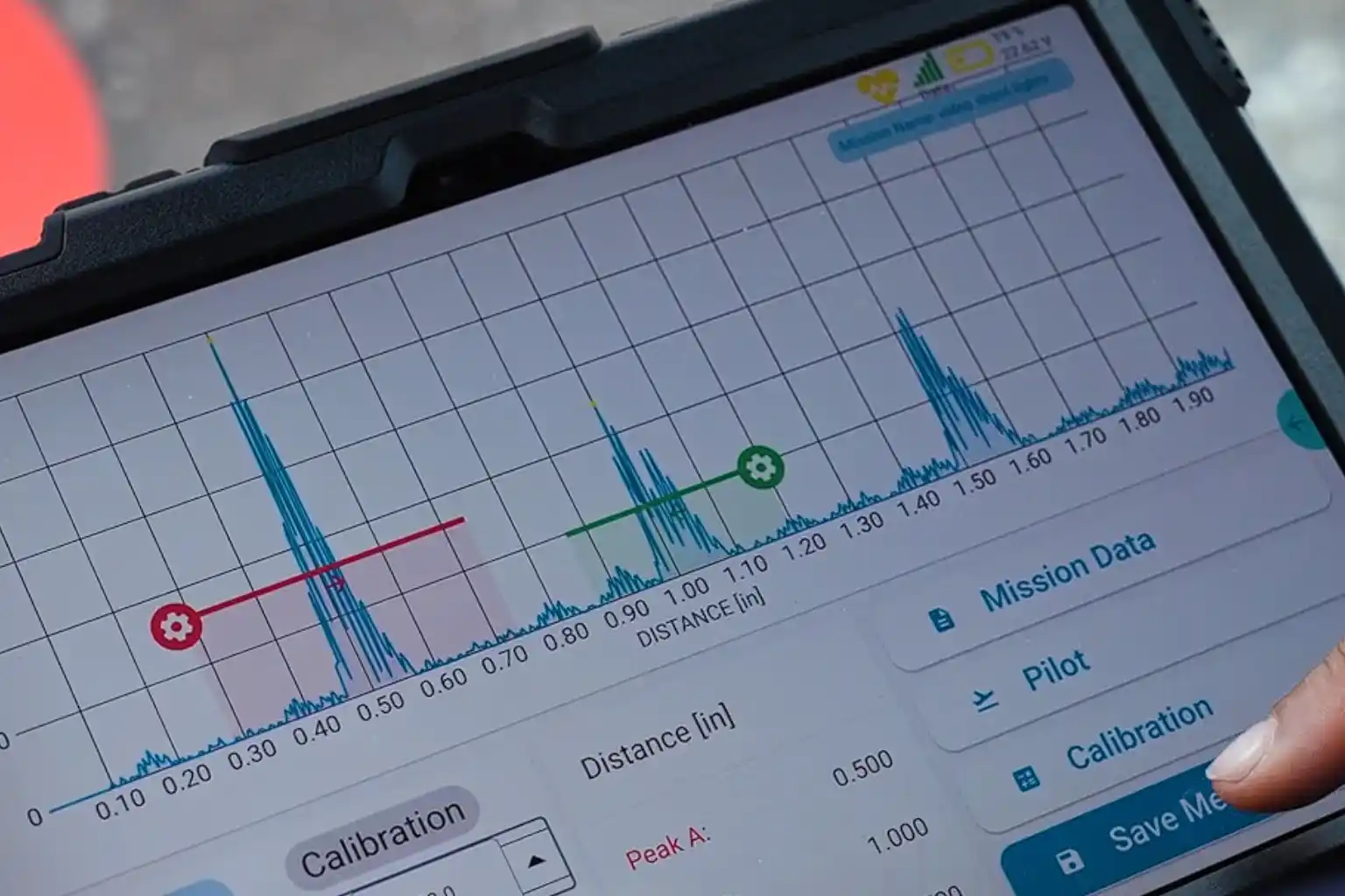
The crucial step for determining true structural integrity is measuring wall thickness. Advanced aerial robotic platforms like the Voliro T now perform this Non-Destructive Testing (NDT) task.
- Contact Measurement: The Voliro T drone carefully approaches the metal surface of the asset be it the roof of a storage tank or a vertical wall and gently places a contact sensor on the surface. This stable contact allows the Voliro T to measure the wall thickness from the outside.
- Corrosion Detection: By comparing this measured thickness to the original blueprint specification, we immediately detect corrosion and material loss. This confirms whether the asset remains structurally sound.
- Data Traceability: The UT reading is captured digitally, stamped with its exact GPS location, and immediately linked to a photograph of the contact point. This provides auditable data that meets the strict traceability requirements of industry standards.
Technical and Operational Benefits
Adopting corrosion inspection with drone-based visual and UT systems delivers clear, quantifiable advantages for safety, finance, and long-term planning.
IV. Technical and Operational Benefits of Drone NDT
The fusion of aerial access and digital NDT transforms risk management into a strategic asset.
A. Safety and Efficiency Gains
- Zero High-Altitude Risk: Drones perform all inspections—from pipe racks to flare stack tips—without putting a single worker at risk of falling or entering a dangerous atmosphere.
- Confined Space Safety: Using drones like the Terra Xross 1 for internal inspections ensures personnel do not enter hazardous vessels, directly solving a major industry safety issue.
- Minimal Shutdown Time: Drones perform inspections much faster, allowing facilities to maintain operational continuity. This significantly cuts downtime and maximizes productivity. This enhanced safety record supports ISO 45001 occupational health standards.
- Efficiency: Drone inspection missions are quick. When compared to the weeks needed for scaffolding, drone operations reduce inspection time by up to 70% for an asset, saving labor and rental costs.
B. Accuracy and Predictive Maintenance
- Consistent Data: Drone flight paths are automated and repeatable. This ensures every inspection captures data from the exact same location as the previous one, providing reliable change detection over time.
- Traceable UT Data: Drone UT data is recorded with precise GPS location and photo documentation, providing level 3 traceability that meets API 653 standards, which governs above-ground storage tank inspection. This removes the subjectivity often found in manual reports.
- digital twin Integration: All visual maps, defect locations, and UT thickness measurements are immediately integrated into the asset’s digital twin. This living replica allows managers to perform predictive maintenance and accurately calculate the asset’s remaining useful life (RUL).
C. Compliance and Standardization
The use of drone technology supports major regulatory frameworks, ensuring structural integrity compliance.
- Integrity Standards: Drone NDT techniques support inspection requirements under standards such as API 653 (Storage Tanks) and ISO 9712 (Qualification of NDT Personnel).
- Standardization: As drone technology matures, collaborating with inspection bodies helps standardize these UAV-based NDT workflows, securing the technology’s place as a primary integrity tool.
Toward Intelligent Corrosion Management
The era of slow, dangerous, and subjective industrial inspections is ending. The high-resolution, centimeter-accurate data delivered by corrosion inspection with drone-based visual and UT systems is the central component of intelligent asset management strategies in the MENA region.
V. Advancing Corrosion Management
The most forward-thinking companies are now integrating this data into their existing management systems.
- Risk Analytics: Combining drone data with GIS (Geographic Information Systems) and analytics allows companies to proactively identify corrosion hotspots across an entire facility, moving from single-asset checks to comprehensive, site-wide risk monitoring.
- Pilot Projects: We strongly encourage pilot projects to validate UAV-based NDT workflows on specific assets. This allows technical teams to directly compare the safety, speed, and accuracy against conventional methods in their own environment.
- Collaboration: Successful adoption requires collaboration. Inspection teams, engineers, and regulatory bodies must work together to integrate the efficiency of drones into standardized integrity inspection procedures.
Terra Drone Arabia is ready to partner with you on this transition. We offer established NDT workflows, certified operators, and proprietary technology, like the Voliro T and Terra Xross 1, necessary to deliver reliable, traceable data for corrosion inspection with drone-based visual and UT systems.
Visit us at MECC 2025 for live demonstrations and technical discussions to see the non-contact UT process in action.