In the traditional era of drone mapping, the capture of aerial imagery was only half the battle. For years, the bottleneck was the processing, loading thousands of high-resolution images onto local workstations that would churn for days to produce a single orthomosaic. This fragmented approach led to data silos, inconsistent results, and a lack of real-time collaboration.
Today, we are witnessing a paradigm shift. Site Scan for ArcGIS, a cornerstone of the ArcGIS Reality suite, has transformed drone mapping into a seamless, end-to-end cloud-based workflow. By leveraging the unlimited scalability of the cloud, organizations can now handle massive datasets that were previously impossible to process locally. This is not just a change in software; it is an evolution of how we perceive and manage physical reality. From automated flight planning in the field to advanced AI analytics in the boardroom, the cloud is the engine driving the next generation of industrial intelligence.
Autonomous Field Operations
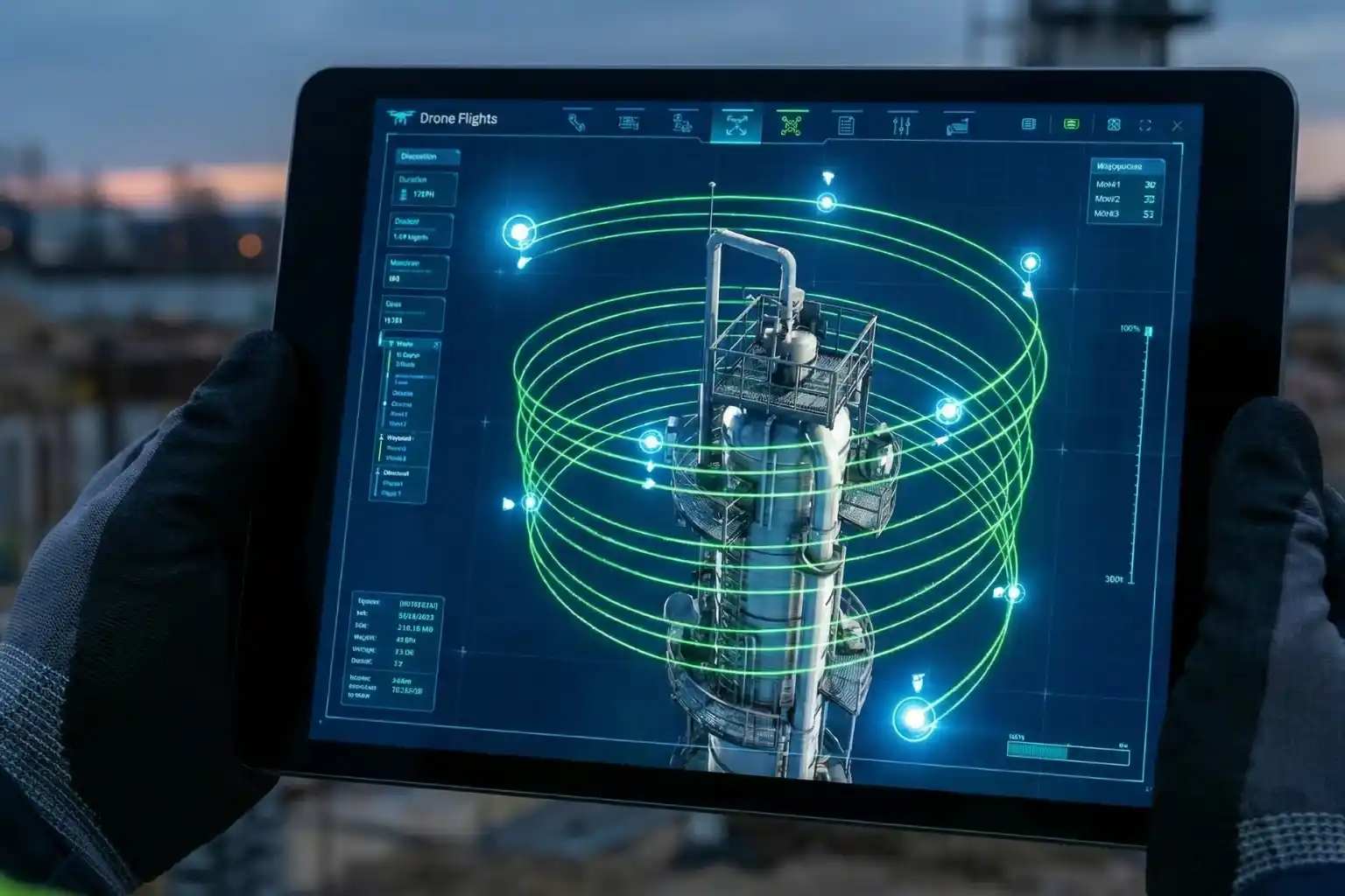
Technical excellence in drone mapping is not a product of chance; it is a meticulously engineered outcome that begins long before the drone ever leaves the ground. Within the site scan for ArcGIS cloud-based operations ecosystem, the ArcGIS Flight app serves as the sophisticated “tactical interface.” It shifts the paradigm from manual, pilot-dependent flight to a software-defined, repeatable mission architecture that ensures absolute data fidelity.
I. Advanced 3D Mission Architectures and Photogrammetric Geometry
Modern industrial assets, ranging from sprawling refinery complexes to complex bridge structures require more than a standard 2D “lawnmower” grid. To build a true Digital Twin, the system must capture the “verticality” and occlusion zones of an asset.
- Perimeter and Crosshatch Missions: For assets with significant vertical relief, such as telecommunications towers or high-rise construction sites, the system utilizes “Perimeter Scans.” The drone executes a series of concentric orbits at multiple altitudes, with the gimbal automatically adjusting its pitch to maintain a consistent angle toward the center. This ensures that every vertical face is captured with high overlap, typically maintained at 80% sidelap and 80% frontlap, providing the dense point cloud required for sharp, un-warped 3D meshes.
- Corridor Mapping and Vertical Inspection: For linear assets like pipelines or highways, the flight app utilizes corridor-specific algorithms that optimize the flight path to minimize battery consumption while maximizing coverage. In vertical inspection modes, the drone maintains a precise, fixed “stand-off” distance from a vertical face (like a dam wall or pylon), capturing high-resolution “flat” imagery that can be processed into specialized vertical orthomosaics.
II. Intelligent Terrain Following and GSD Consistency
One of the most critical variables in photogrammetry is the Ground Sample Distance (GSD), the physical distance on the ground represented by a single pixel. If a drone flies at a constant altitude above sea level while the terrain rises and falls, the GSD varies, leading to inconsistent resolution and measurement errors.
- Dynamic Altitude Adjustment via DEM Integration: ArcGIS Flight integrates high-resolution digital elevation models (DEMs). The drone dynamically adjusts its altitude in real-time to maintain a constant height above the ground surface. This results in a uniform GSD across the entire dataset, ensuring that a measurement taken on a mountain peak is as accurate as one taken in a valley.
- Automatic Overlap Recalculation: The software monitors ground speed and wind resistance in real-time. If the drone encounters a strong headwind, the system recalibrates the shutter trigger intervals. This ensures the required overlap is maintained perfectly, preventing “gaps” in the data that could lead to failures during the cloud-processing phase.
III. Sensor Integration and Field-Level Georeferencing
The accuracy of the final map is only as good as the metadata attached to each image. Site Scan supports advanced hardware integration to eliminate the need for traditional, time-consuming ground surveys.
- RTK and PPK Workflows: The flight app natively communicates with Real-Time Kinematic (RTK) and Post-Processed Kinematic (PPK) enabled drones. By receiving corrections from a base station or NTRIP network, the drone geotags each image with centimeter-level accuracy at the moment of capture. This minimizes, and often eliminates, the need for laying manual Ground Control Points (GCPs), saving hours of field labor.
- Multi-Sensor Support: Beyond standard visual (RGB) sensors, the framework supports multispectral and thermal payloads. This allows for the capture of specialized data layers. such as vegetation health indexes or thermal signatures for solar farm inspections. All managed within the same autonomous flight interface.
IV. Pre-Flight Rigor and Field-to-Cloud Synchronization
- Custom Safety Checklists: To ensure enterprise-wide compliance, administrators can push mandatory pre-flight checklists to the field app. Pilots must verify everything from airspace authorization (LAANC) to battery voltage and signal strength before the “Take Off” button is enabled.
- Quick Tiling for Field Verification: One of the most powerful features of the cloud-based operation is Quick Tiling. Immediately after landing, the pilot can generate a low-resolution orthomosaic preview in the cloud while still on-site. This allows for instant verification: Did we cover the entire site? Are there any blurry images due to low light? If a gap is detected, the pilot can re-fly the specific segment immediately, preventing a costly return trip to a remote site.
Transforming Pixels into Insight

The true technical “engine” of site scan for ArcGIS cloud-based operations lies in its processing architecture. By decoupling data computation from physical hardware, Site Scan leverages the elastic power of the cloud to perform complex photogrammetric reconstructions that would overwhelm even the most advanced local workstations. This section explores the mechanics of how raw aerial imagery is transformed into a high-fidelity geospatial intelligence product.
I. Elastic Computing and Massive Parallelization
Traditional photogrammetry is a computationally “heavy” task that requires intense CPU and GPU resources. In a local environment, this creates a linear bottleneck: the more images you have, the longer you wait. Site Scan solves this through massive parallelization.
- Distributed Task Processing: When a dataset is uploaded to the Site Scan Manager, the cloud architecture breaks the project into thousands of discrete tasks. These tasks are distributed across an elastic cluster of server nodes. For instance, while one node calculates the internal orientation of a camera, another is simultaneously identifying common points across five different images.
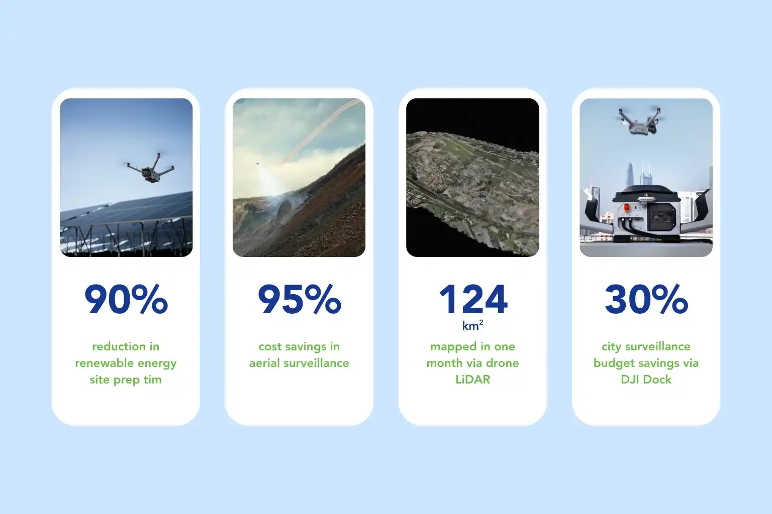
- Embarrassingly Parallel Workflows: Photogrammetry is “embarrassingly parallel,” meaning it can be easily separated into many parallel tasks. Site Scan utilizes this to process 5,000+ images in roughly the same time it takes to process 500 on a local machine. This shifts the industrial model from a CAPEX-heavy one (buying expensive hardware) to an OPEX-efficient one (paying only for the computing power used).
II. The Mechanics of Structure-from-Motion (SfM)
The heart of the processing engine is the structure-from-motion (SfM) algorithm. This is the mathematical process of estimating three-dimensional structures from two-dimensional image sequences coupled with local motion signals.
- Feature Extraction and Matching: The engine scans every image for “keypoints,” distinctive visual markers like building corners, rock textures, or road markings. It then uses advanced descriptors to match these keypoints across multiple overlapping photos.
- Bundle Adjustment: Once matches are found, the system performs a “Bundle Adjustment.” This is a massive simultaneous triangulation that calculates the precise $X, Y, Z$ position and the tilt/roll/yaw (orientation) of the camera for every single shot.
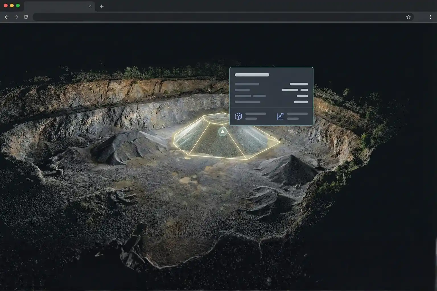
- Sparse to Dense Point Cloud: The initial result is a “Sparse Point Cloud” representing the core geometry. The engine then fills in the gaps through multi-view stereo (MVS) matching to create a “Dense Point Cloud,” where every point is assigned an RGB value from the original photos.
- 3D Mesh and Orthorectification: Finally, the system drapes a triangular “mesh” over the points and applies the high-resolution photo textures. For 2D maps, it “orthorectifies” the imagery, removing perspective distortion caused by the camera lens and the terrain, resulting in a map where every distance can be measured as accurately as a flat surface.
III. Geospatial Anchoring and Absolute Accuracy
For industrial applications, a map must not only look good; it must be geographically perfect. Site Scan ensures geospatial integrity through sophisticated anchoring workflows.
- In-Browser GCP Marking: For projects requiring absolute accuracy (accuracy relative to the real world), users can upload Ground Control Point (GCP) coordinates. The Site Scan Manager allows users to manually “pin” these coordinates on the raw photos directly in the web browser. The engine then re-calculates the entire block adjustment to “stretch” the map to fit these known points perfectly.
- RTK/PPK Fusion: When using high-end drones, the cloud engine ingests high-precision metadata captured during flight. It merges the GPS/GNSS corrections with the visual data to produce a model with centimeter-level accuracy without the need for manual GCP marking, significantly accelerating the “time-to-insight” for critical projects.
Advanced Analytics and Stakeholder Collaboration
Once the data is processed, it becomes a “living” asset accessible to any authorized user with a web browser. Site Scan for ArcGIS provides a suite of analysis tools that bring the field to the office.
I. Precision Measurement and Volumetric Tools
- ** stockpile Volumetrics: Within the Site Scan Manager, users can perform complex volumetric calculations. By drawing a polygon around a stockpile, the system compares the current surface to a base plane (or a previous survey), providing instant volume data, cut/fill values, and elevation profiles.
- Distance and Slope Analysis: Users can measure distances, areas, and slopes directly on the 2D orthomosaic or 3D mesh. This is critical for construction site monitoring, where verifying a slope gradient for drainage is a frequent requirement.
II. Temporal Monitoring and Progress Tracking
- The Time-Slider Tool: The cloud manager hosts a “Time-Slider” that allows stakeholders to flip between different survey dates. This visual comparison highlights exactly how a site has changed over days, weeks, or months.
- Change Detection Overlays: By overlaying two orthomosaics, the software can automatically highlight differences in elevation or footprint, allowing project managers to detect unauthorized site changes or progress delays instantly.
III. Enterprise Integration and the Digital Thread
- ArcGIS Ecosystem Sync: Processed layers can be pushed directly to ArcGIS Online or ArcGIS Enterprise with a single click. This allows the drone data to be used in Dashboards, StoryMaps, or Experience Builder applications for executive reporting.
- AEC Industry Connectivity: Site Scan integrates with Autodesk BIM 360, allowing construction managers to overlay drone “as-built” data directly on top of 3D CAD designs. This “design-vs-actual” comparison is the gold standard for clash detection and quality control in modern infrastructure projects.
Fleet Management and Compliance
Scaling a drone program across an enterprise requires administrative rigor. Site Scan for ArcGIS provides a centralized “System of Record” for the entire operation.
I. Centralized Fleet and Hardware Tracking
- Automated Flight Logs: The platform automatically logs every flight, capturing the hardware used, the pilot in command, the total flight duration, and the battery health.
- Battery Lifecycle Management: By tracking the number of charge cycles and internal resistance for every battery, the system ensures that pilots only use equipment that is in peak condition, reducing the risk of in-flight failure.
II. Pilot Certification and Safety Compliance
- Credential Management: Administrators can store and track pilot certifications, such as GCAA or FAA licenses. The system can be configured to prevent pilots from uploading data if their certifications have expired, ensuring total regulatory compliance.
- Audit-Ready Checklists: Every pre-flight checklist completed in the field is stored in the cloud. In the event of an audit or incident investigation, a complete history of safety checks for any flight can be retrieved instantly.
III. Data Governance and Security
- Granular User Permissions: In an enterprise environment, data security is paramount. Site Scan allows for granular roles, ensuring that field pilots can upload data, engineers can perform measurements, and external clients can only view final reports.
- Secure Cloud Infrastructure: Built on top of enterprise-grade cloud architecture, Site Scan ensures that sensitive industrial data is encrypted both at rest and in transit, meeting the security standards required by national infrastructure and energy companies.
Driving Industrial Efficiency
The implementation of site scan for ArcGIS cloud-based operations represents the final step in the maturity of a drone program. By moving the heavy lifting of data management and processing to the cloud, organizations eliminate the need for specialized local workstations and reduce the time-to-insight from days to hours.
The cloud enables a truly collaborative environment where data captured on a remote site in the morning can be analyzed by an engineer in a different city by the afternoon. For industries like Construction, Oil & Gas, and Mining, this speed and accuracy are the keys to reducing operational risk and maximizing ROI. As we continue to build the digital twins of our national infrastructure, Site Scan for ArcGIS will remain the essential cloud engine that turns aerial pixels into the geospatial intelligence of the future.
Here are five easy, simple, and relevant visual suggestions tailored for the editorial on site scan for ArcGIS cloud-based operations, designed to visually guide the reader through the end-to-end workflow.