Navigating the Industrial Abyss
- The Complexity of 2026: Subsea operations have evolved beyond simple visual checks to requiring high-precision data, physical interaction, and deep-water endurance.
- The Multi-Disciplinary Challenge: No single tool fits all tasks, aquaculture requires agility, while offshore energy demands heavy-duty payloads and millimetric metrology.
- The Solution: Introducing the QYSEA FIFISH ROV Lineup, an AI-powered fleet designed to provide modular, scalable, and intelligent solutions for every underwater industrial sector.
Specialized Tools for Specialized Missions
The shift toward autonomous subsea auditing requires more than just a camera on a tether; it requires a specialized workforce of robotic agents. QYSEA’s lineup is engineered to bridge the gap between raw data collection and actionable engineering intelligence.
1. FIFISH V-EVO: The High-Frame-Rate Visual Metrology Standard
The FIFISH V-EVO is the premier choice for visual-first inspections where motion clarity and environmental realism are critical.
- High-Speed Imaging Architecture: The V-EVO features a 4K UHD camera capable of 60 frames per second (fps). This higher frame rate is essential for capturing smooth footage of fast-moving turbine blades, propeller shafts, or moving biological stock in aquaculture, preventing the “motion blur” that plagues standard 30fps ROVs.
- Adaptive AI Plankton Filtering: One of the primary barriers to underwater clarity is “marine snow” suspended particles and plankton that reflect light and obscure details. The V-EVO utilizes an Adaptive AI filtering algorithm to digitally remove these visual obstructions in real-time, restoring clarity to images even in nutrient-rich or turbid coastal waters.
- Optics and Illumination: With a 166° ultra-wide field of view (FOV) and 5,000-lumen LED lights (5500K color temperature), the V-EVO maximizes situational awareness, allowing pilots to see structural contexts that narrower lenses miss.
- AI Vision Station Lock: Using machine vision, the V-EVO can lock onto a specific underwater subject, maintaining its relative position and focus with a single touch, which is critical for long-term observation of slow-growing corrosion or biological samples.
2. FIFISH E-GO: Biomimetic Agility for Industrial Productivity
Designed with a “Hammerhead” shark-inspired form factor, the E-GO focuses on hydrodynamic efficiency and rapid operational switching.
- Ring-Wing Motor Propulsion: The E-GO utilizes a patented ring-wing motor system that provides a 30% power increase over traditional designs. This allows the drone to maintain speeds of 3+ knots even when fighting strong lateral currents common in open-water cage farming.
- The 9-Second Modular Ecosystem: To minimize site downtime, the E-GO features a quick-release accessory system allowing for tool installation in under 9 seconds. This enables a single ROV to transition from a net-repair mission to a water-quality sampling mission in seconds.
- Hot-Swappable Dual Power: The E-GO’s dual-battery architecture supports hot-swapping, meaning the ROV can stay powered on and connected to the station while batteries are replaced, enabling continuous “infinite” workflows without restarting missions.
- Macro Precision: A focused 10cm macro range allows the E-GO to perform extreme close-up inspections of welds, bolts, and delicate marine life that would be out of focus for standard industrial cameras.
3. FIFISH V6 PLUS: The Expert in Millimetric Structural Metrology
The V6 PLUS is the enterprise benchmark for non-destructive testing (NDT) and precision measurements.
- Machine Vision AR Ruler: Moving beyond simple visual estimation, the V6 PLUS features a patented AR Ruler system. By combining machine vision with a laser scaler, it achieves a measurement precision of ±1cm, allowing engineers to accurately measure the length, width, and area of structural defects directly through the FIFISH App.
- Sonic Distance & Altitude Lock: Dual sonar sensors provide real-time distance and altitude tracking. The “Distance Lock” maintains a fixed stand-off distance from a hull or wall, while “Altitude Lock” maintains a fixed height above the seabed, ensuring the ROV does not drift during delicate NDT scans.
- Deep-Water Operational Envelope: Rated for 150 meters, the V6 PLUS is built for the deeper inspection requirements of hydropower dams, reservoir gates, and bridge pilings.
4. FIFISH V6 EXPERT: The Multi-Tool Platform for Complex Intervention
The V6 EXPERT is the “Swiss Army Knife” of the lineup, designed to carry heavy payloads and diverse sensor arrays.
- Q-IF Interface Expansion: The V6 EXPERT features a heavy-duty Q-Interface that supports the simultaneous integration of up to 20+ professional tools. These include water samplers (100ml to 1500ml), pH/salinity/turbidity sensors, retrieval hooks, and underwater dozers.
- Onshore Power Supply System (OPSS): For missions requiring days of continuous monitoring, the V6 EXPERT can be tethered to an onshore power system, removing battery limitations and allowing the drone to stay submerged indefinitely for long-duration infrastructure audits.
- Enhanced 6000 Lumen Illumination: Dual 3000-lumen headlights provide the ultra-bright lighting necessary for the V6 EXPERT to perform manipulation tasks in the absolute darkness of deep-sea tunnels or silt-heavy environments.
5. FIFISH E-MASTER: The Vessel Hull and Bathymetric Specialist
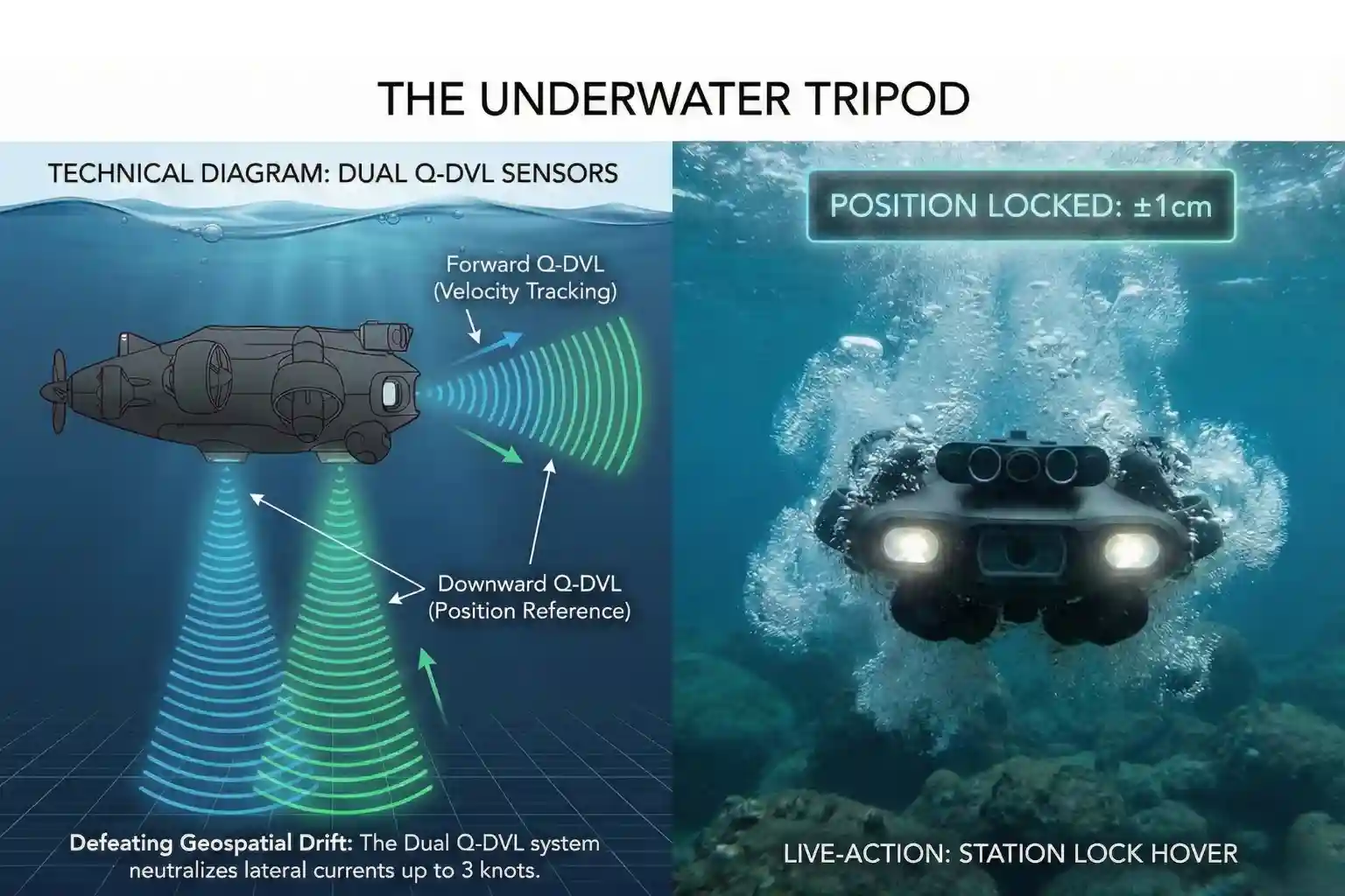
The E-MASTER is a revolutionary industrial AI ROV engineered for hull inspections and seabed mapping.
- Q-DVL Stabilized Hovering: The E-MASTER integrates both forward and downward Q-DVL (Doppler Velocity Log) modules. This allows for Station Lock Hovering against vertical hulls or moving currents, ensuring the drone remains perfectly steady while measuring biofouling or coating degradation.
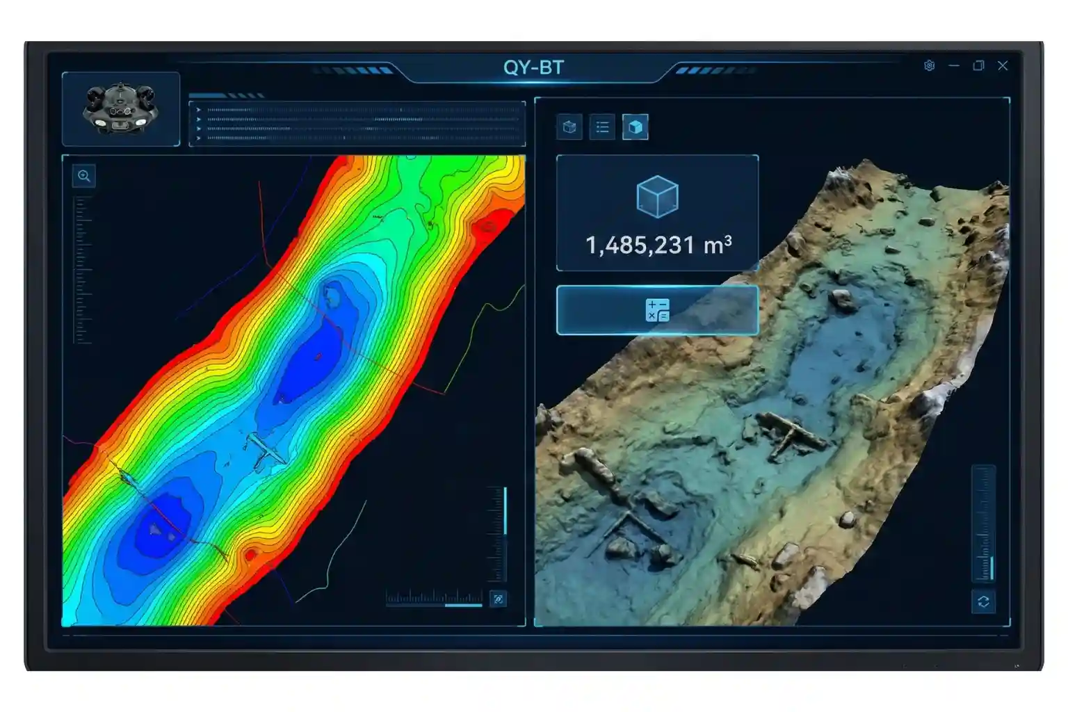
- Integrated Bathymetric Mapping (QY-BT): By fusing data from the Q-DVL and echosounders, the E-MASTER can perform automated 2D and 3D seafloor mapping. Operators can generate topographic maps and calculate reservoir capacities with a single click.
- AI Measurement Accuracy: Using the QY-MT system, the E-MASTER can analyze underwater objects and fractures with a staggering 99.7% measurement accuracy, providing the high-fidelity data required for class-certified hull inspections.
6. FIFISH X1: The Heavy-Duty Offshore Intervention Powerhouse
The X1 is a mission-class ROV designed to handle the most demanding conditions in the offshore energy sector.
- Heavy Payload and Propulsion: The X1 supports an massive 15kg payload capacity and is powered by the Q-Motor Pro system, which allows it to hold its position and operate in currents up to 4.0 knots.
- U-INS Plus Inertial Navigation: This system fuses data from the Q-DVL, accelerometers, gyroscopes, and magnetometers to enable precise 3D route planning. The X1 can autonomously navigate complex “jackets” and oil rig structures, following preset paths while the operator focuses on data collection.
- Tri-Directional Collision Avoidance: To protect the asset and the ROV, the X1 features a tri-directional sonar array that scans for obstacles in real-time, automatically stopping or maneuvering the drone to prevent impacts in the tight spaces of subsea infrastructure.
7. FIFISH W6 NAVI: The Critical Agent for Search, Rescue, and Security
The W6 NAVI is a professional-grade maritime platform designed for situational awareness in high-stakes missions.
- Dual 4K Camera Coordination: The W6 NAVI features an innovative Dual 4K camera system. This allows the pilot to use one camera for wide-angle environmental navigation while the second camera focuses on high-detail monitoring of a robotic arm or sonar feed, providing a comprehensive underwater perspective without switching views.
- U-QPS2 Global Positioning: The Underwater Quick Positioning System (U-QPS2) provides real-time GPS-mapped coordinates, path recording, and POI marking. This is critical for search and rescue teams to mark the exact location of a target or for security teams to map a repeating patrol route around sensitive ports.
- Rescue-Class Endurance: Equipped with a 388.8Wh swappable battery and supporting fast-charging (70% in one hour), the W6 NAVI is built for extended deployments where every minute counts.
Advanced Industrial Intervention
To meet the high-stakes demands of 2026 subsea operations, the FIFISH lineup transitions from observation-class tools to heavy-intervention platforms. This section details the technical architecture of the three models designed for high-intensity industrial work: the E-MASTER, the X1, and the W6 NAVI.
5. FIFISH E-MASTER: The Precision Survey & Mapping Specialist
The FIFISH E-MASTER is engineered for survey teams and engineers requiring high-fidelity spatial data in moving water.
- Acoustic & Inertial Synergy: The E-MASTER integrates both Forward and Downward Q-DVL (Doppler Velocity Log) modules. This hardware allows the ROV to lock its position relative to the seabed or a vertical structure with a precision of ±1 cm, effectively neutralizing currents of up to 3 knots.
- Bathymetric Power (QY-BT): Utilizing the QYSEA Bathymetric Tool, the E-MASTER serves as a dynamic hydrographic platform. It can generate customizable 2D and 3D topographic maps of seabeds or reservoir floors with a single click, providing critical data for capacity estimation and scour monitoring.
- Ring-Wing Propulsion: At its core is a bionic ring-wing motor system. By increasing the propeller blade area, this design delivers a 30% power boost over traditional thrusters, ensuring stable maneuverability even when equipped with heavy acoustic sensors.
- Smart Measurement (QY-MT): The proprietary AI measurement system achieves 99.7% accuracy. By fusing laser data with machine vision, operators can measure fractures, corrosion areas, and biological growth directly on the operational screen in real-time.
6. FIFISH X1: The Multi-Tool Offshore Workhorse
The FIFISH X1 is a “Mission Class” ROV designed to replace human divers in high-risk offshore energy environments.
- Heavy Payload Architecture: With a maximum payload capacity of 15kg and a rugged depth rating of 350 meters, the X1 is built for structural intervention. It features four Q-interface power ports, allowing it to simultaneously run complex tool skids such as high-pressure cleaners and NDT sensors.
- Non-Destructive Testing (NDT) Suite:
- Ultrasonic Thickness Gauge (UTG): Measures metal loss and internal corrosion without damaging protective coatings.
- Cathodic Protection (CP) Probe: Safely assesses the potential data of sacrificial anodes on oilfield jackets.
- Unlimited Operational Endurance: The X1 standardizes the Direct Power Supply System (DPSS). By utilizing a continuous power cable, the ROV can operate 24/7 without battery limitations, essential for long-duration pipeline audits or wind farm foundation checks.
- Safety & Collision Avoidance: To navigate complex steel jackets, it utilizes a tri-directional collision avoidance sonar. This system scans the environment in real-time and provides customizable distance alerts to prevent impact in low-visibility or high-turbidity zones.
7. FIFISH W6 NAVI: Intelligence-Driven Search & Recovery
The FIFISH W6 NAVI is the lineup’s flagship for Search & Rescue (SAR) and maritime security.
- Dual 4K Visual Coordination: Unlike single-camera units, the W6 NAVI uses a Dual 4K Camera System to coordinate “operation monitoring” with “motion observation”. While the bottom camera monitors a robotic arm interacting with a target, the front camera maintains a 166° horizontal field of view for total situational awareness.
- U-QPS2 Global Positioning: The ROV is integrated with the underwater quick positioning system (U-QPS2). This allows pilots to map real-time coordinates, log Points of Interest (POIs), and record 3D dive paths. In SAR missions, this enables the systematic coverage of a search grid with millimetric tracking.
- Advanced SAR Payloads: The W6 NAVI can be customized with a robotic arm featuring replaceable claws (up to 20kgf grip) for recovering submerged objects. For zero-visibility scenarios, it integrates 2D imaging sonar that can scan environments up to 25 meters away, detecting human signatures or wreckage through the murk.
Standardizing Your Subsea Strategy
In the 2026 industrial landscape, the transition from legacy ROVs to a modular, AI-driven fleet is a requirement for operational efficiency. Future-proof your maintenance and inspection workflows by selecting the platform that matches your asset’s depth, payload, and data requirements.
Standardize your deepwater integrity. Partner with us to integrate the QYSEA FIFISH lineup into your operations and redefine your subsea capabilities with measurable, professional results.