
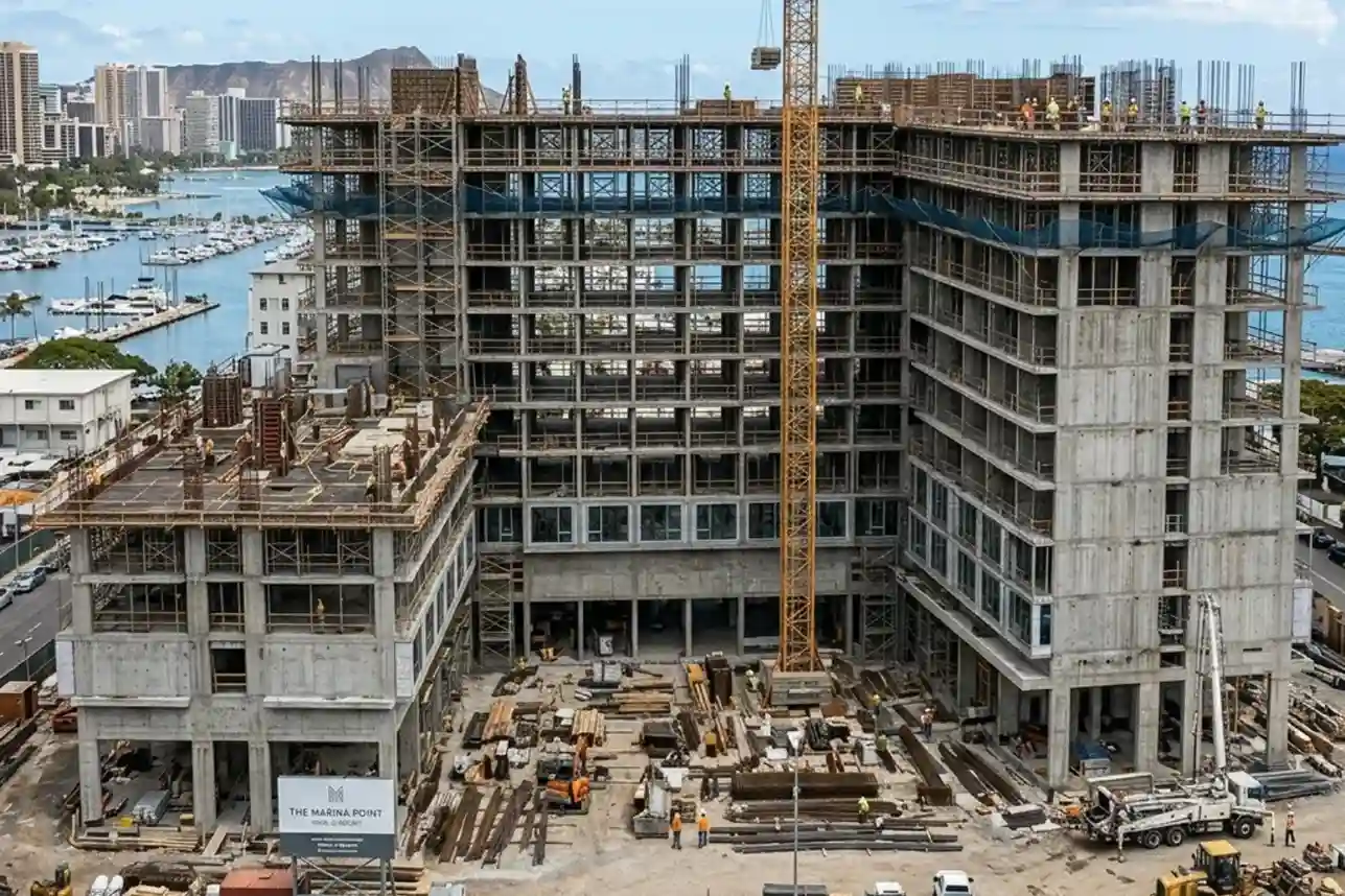
The SAR 2.7 Billion Diriyah Megaproject
The Diriyah Company’s recent award of a SAR 2.7 billion contract to the joint venture of Hassan Allam Construction Saudi and UCC Saudi marks the official construction launch of the Waldorf Astoria superblock.
This high-profile mixed-use development features a 200-key luxury hotel, 47 branded residences, commercial facilities, and modern office spaces.
These major infrastructure assets must progress rapidly to meet the tight scheduling demands of Saudi Arabia’s Vision 2030 initiatives.
However, fast-tracking remote commercial developments faces a well-documented global challenge.
The international construction sector suffers from a chronic efficiency crisis, where sector productivity has grown at a low rate of just 0.4% annually over the last two decades.
Because of these deep operational tracking inefficiencies and structural execution gaps, the global construction industry leaves SAR 6 trillion on the table every single year.
Remote megaprojects have zero tolerance for these timeline extensions.
To maintain momentum, developers are shifting away from traditional progress tracking toward regular 3D digital twin audits to gain real-time site visibility.
The Billion SAR Threats of Early-Stage Construction
During the initial earthworks, grading, and excavation phases of the Waldorf Astoria superblock, exact spatial measurement forms the baseline for all future structures.
In remote locations, engineering teams often face severe visibility issues when trying to track how the physical ground changes day by day.
Relying on paper blueprints, manual field notes, or uncalibrated site photos means that the data used by decision-makers is frequently outdated before it even reaches the project office.
The High Cost of Outdated Site Information and Hidden Tolerances
When site engineers make critical building decisions based on wrong or old field data, the financial consequences are massive.
Industrial research shows that using incorrect or obsolete site information costs the global construction industry over SAR 333 billion in a single year in rework alone.
This specific type of error accounts for roughly 14% of all construction rework performed across major infrastructure projects.
When a team pours a concrete foundation pile or installs an underground utility line in the wrong spot because they used incorrect field data, the mistake remains completely invisible until the next phase of construction begins.
By then, the fix requires physical demolition, heavy equipment removal, and rebuilding from scratch, wasting millions of dollars before the building ever rises above the ground.
The Compounding Effect of Early Foundation Deviations
In high-density developments like the Waldorf Astoria superblock, the structural plan relies on tight tolerances.
Tolerances are the tiny, permissible margins of error allowed during physical building.
In early-stage engineering, a deviation of just a few millimeters in a foundational column might seem minor.
However, as the building grows vertically, these tiny placement errors compound exponentially.
A five-millimeter tilt at the base can shift the top floor by several inches, making it impossible to install prefabricated walls, windows, or structural steel beams designed under strict factory specifications.
When these spatial variances are left unmapped, they directly degrade the entire financial health of the project.
Industrial studies show that combined direct and indirect costs from these errors can drain up to 9% of total project budgets.
The damage is not just financial; it severely impacts the day-to-day work on the site.
Discovering a structural clash late creates a massive logjam, forcing a staggering 300% drop in localized worker productivity.
Instead of installing new components, specialized tradespeople must sit idle while engineers run manual calculations, redraw structural designs, and order replacement materials.
This operational halt creates a domino effect that delays downstream contractors, compromises sub-surface waterproofing, and strains the overall development schedule.
The Operational Breakdown of Manual Inventory and Progress Tracking
Traditional progress tracking methods are fundamentally inadequate for a high-speed superblock layout.
Most construction sites still depend on manual gate logs, physical ground walks, and paper manifests to track materials and monitor structural progress.
On a massive, multi-use site, a small team of inspectors cannot walk the entire footprint daily to verify the placement accuracy of every single piece of reinforcing steel, concrete formwork, or utility pipe.
This manual approach creates dangerous data silos and significant blind spots.
By the time a ground surveyor manually spots that an underground pipeline intersects incorrectly with a foundation beam, hours or days of active building time have passed.
The delay grows even worse when managing complex supply chains where materials arrive continuously by transport trucks or supply vessels.
Without a live, highly detailed map of the layout, site managers cannot quickly verify if incoming components are being placed in the correct sequence or stored in the right staging sectors.
This lack of clear spatial tracking causes double-handling of heavy materials, increases machinery wear, and allows small, correctable alignment issues to turn into multi-million dollar structural execution gaps.
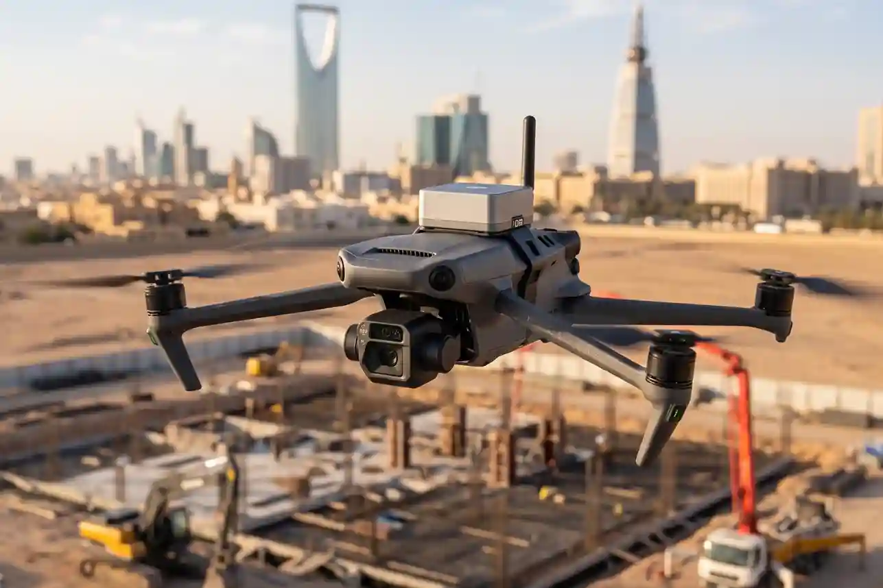
Deploying DJI Mavic 3 Enterprise for Automated Spatial Audits
To eliminate these measurement blind spots and establish absolute structural transparency, field teams deploy the compact DJI Mavic 3 Enterprise drone directly across active construction zones.
This aerial system acts as a reliable digital bridge between off-site fabrication plants and the physical reality of the changing landscape.
Instead of waiting days for ground survey teams to manually measure site coordinates, the deployment of an aerial reality capture workflow allows project managers to evaluate the entire physical state of the superblock in a fraction of the time.
High-Speed Mapping via Mechanical Shutter and Centimeter-Level RTK Synchronization
Standard commercial drones rely on internal GPS receivers that can drift by several meters depending on atmospheric interference, cloud cover, and satellite positions.
For a precise architectural layout like the Waldorf Astoria superblock, an operational variance of even a few meters can cause multi-million dollar structural components to misalign completely during assembly.
The DJI Mavic 3 Enterprise resolves this specific issue by utilizing its screw-on, top-mounted Real-Time Kinematic (RTK) module.
The RTK module works by constantly communicating with local ground base stations on the site.
This real-time link corrects satellite signals instantly, stamping every captured aerial photograph with exact metadata coordinates that are accurate down to the centimeter.
Because the module continuously overrides satellite drift, engineering teams can guarantee that the spatial data matches the true coordinates of the earth without exception.
Equally important to this data collection pipeline is the drone’s specialized 20-megapixel mapping camera, which features a physical mechanical shutter.
Traditional consumer drones use electronic shutters that record images line-by-line.
When a drone flies fast over a site, this line-by-line recording introduces a “rolling shutter” warping effect, making straight lines, such as concrete column edges, timber beams, and foundation retaining walls.
Appear bent or distorted in the final image.
The DJI Mavic 3 Enterprise’s mechanical shutter opens and closes instantly across the entire sensor, freezing the image completely in place even while the drone travels at high flight speeds.
This hardware capability ensures that all geometric shapes are captured with zero visual distortion.
Because the airframe is light, compact, and fast to deploy, it is perfect for executing routine weekly mapping flights without interrupting heavy machinery or forcing ground crews to halt operations for safety clearances.
Generating High-Density Reality Meshes for Virtual Blueprint Alignment
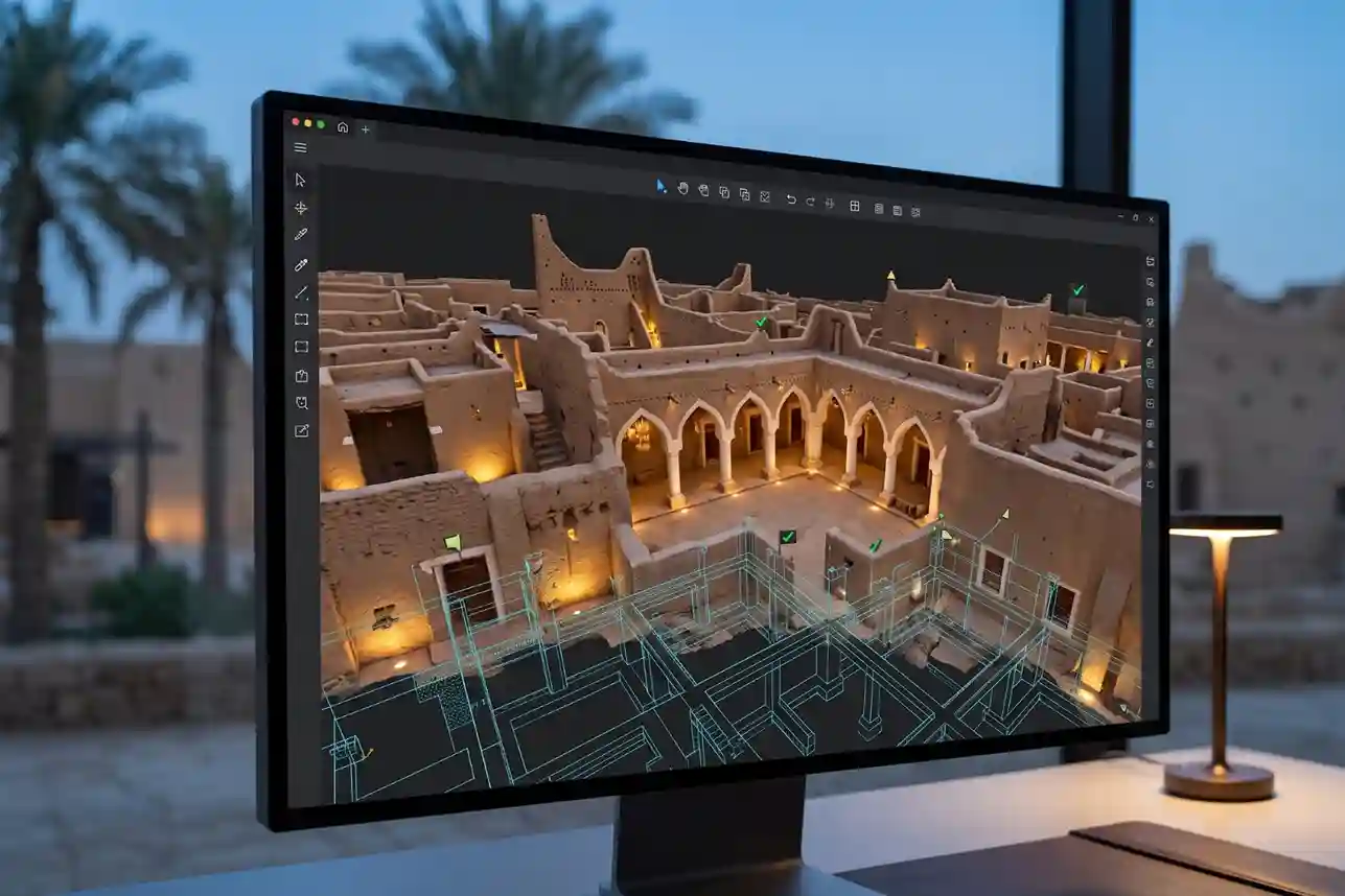
Once the drone completes its pre-programmed automated flight grid over the superblock, the gathered image packages are uploaded directly into specialized photogrammetry software.
The software uses advanced computer vision algorithms to analyze thousands of overlapping pixels across the image set.
By matching identical points found in multiple photos from different angles, the software calculates a high-density point cloud consisting of millions of individual spatial points, which is then converted into a highly detailed 3D digital twin reality mesh of the entire landscape.
This 3D digital twin updates progressively with each new flight, capturing the exact, as-built state of the project.
For the complex structural layout of the Waldorf Astoria superblock, this digital twin functions as an automated virtual alignment audit.
Marine pile installations, underground utility grids, and concrete foundation slabs can be cross-checked almost instantly.
Before expensive prefabricated building assets are shipped from off-site factories, managers can overlay the drone-generated 3D reality mesh directly on top of the original architectural design blueprints or Building Information Modeling (BIM) files.
If a physical foundation column has shifted or skewed by even a minor margin during installation, the software flags the exact physical variance.
Engineers can then adjust connection brackets or modify the assembly sequence digitally before the assets arrive at the project site, completely avoiding the need for incredibly expensive field alterations on active building lines.
Weekly Operational Workflows and the Measurable Business Return
Implementing a progressive site inspection framework using the DJI Mavic 3 Enterprise creates a continuous, highly transparent digital ledger of all construction activities.
Staging yards can be monitored automatically to verify that arriving materials and structural parts are stored in the correct sequence, preventing double-handling errors and lowering machinery transit wear across the development footprint.
This routine approach provides project owners with an indisputable visual record of site work, streamlining contractor communication and simplifying billing verifications based on verified physical progress.
The real-world business return of transitioning from manual oversight to automated drone tracking is well-supported by international infrastructure data.
Independent studies show that between 60% and 70% of construction executives confirm that integrating drone platforms directly into site workflows successfully shortens project schedules and cuts total project costs by at least 10%.
For a massive development like this superblock, a 10% baseline reduction in schedule delays and budget overhead protects valuable downstream capital, eliminates material waste, and ensures long-term operational success.
Cutting Execution Gaps in Infrastructure
Relying on slow field tracking or unverified manual reporting introduces unnecessary risks to large-scale developments.
Transitioning to automated remote spatial audits ensures that building components align perfectly with real-world terrain conditions from the moment they arrive on-site.
This verification process keeps infrastructure timelines secure, logistics optimized, and downstream budgets completely intact.
Consult with our expert today to integrate advanced digital twin and drone logistics management workflows into your next infrastructure project.

