Terra Xross 1: Redefining the Standard for Confined Space Inspection

In the heavy industrial landscape, the most critical assets, such as storage tanks, massive boilers, underground mine shafts, and ship cargo holds are often the most dangerous to inspect. Traditional manual methods require scaffolding, specialized high-risk permits, and placing human lives in dark, dusty, and oxygen-depleted environments. The Terra Xross 1, developed by Terra Drone Corporation in Japan, eliminates these risks by making challenging indoor environments accessible, simple, and safe for every worksite. Navigational Supremacy in GPS-Denied Zones The Terra Xross 1 is specifically engineered to thrive where standard drones fail. By integrating advanced LiDAR-based navigation, the system overcomes the obstacles of indoor dust and total darkness. Stable Flight without GPS: LiDAR sensors ensure steady hovering and precision flight, making operation straightforward even in confined, complex geometries. Visual Odometry: Coupled with LiDAR, visual sensors allow the drone to maintain its position in GPS-denied environments with high reliability. Real-Time 3D Mapping: During Beyond Visual Line of Sight (BVLOS) operations, the drone provides a real-time 3D data view. This grants operators total situational awareness, ensuring safe navigation around internal obstacles without direct line of sight. Precision Imaging and Persistent Operation Industrial maintenance requires high-fidelity data to identify microscopic cracks, corrosion, or structural anomalies. The Terra Xross 1 delivers this intelligence through a robust sensory and power stack: 4K 180° Tilt Camera: The integrated camera provides high-resolution 4K footage, while the 180-degree tilt capability allows for thorough obstacle verification and close-up structural analysis of ceilings and tight corners. Integrated LED Lighting: High-intensity LED illumination ensures that even the darkest chimneys or tanks are rendered with professional-grade clarity. The Tether Advantage: While standard batteries provide 10 minutes of agile flight, the optional Tether System allows for continuous power. This removes the risk of battery exhaustion, enabling exhaustive mapping and multi-hour inspections of massive assets without the need for frequent swaps. Spatiotemporal Cloud Intelligence: Through the Terra Xross Cloud, captured images and videos are automatically associated with 3D point cloud data. This allows maintenance teams to manage data intuitively and share actionable insights with stakeholders worldwide in real-time. Make Innovation Your New Norm From the refineries of the Eastern Region to the shipping ports of the Red Sea, the Terra Xross 1 is transforming how Saudi Arabia maintains its industrial integrity. By offering a platform that balances simplicity with hardcore industrial performance, Terra Drone Arabia is helping companies reduce downtime and prioritize worker safety. Experience the future of industrial maintenance. Contact us today for a FREE demo and see how the Terra Xross 1 can elevate your confined space inspection capabilities to the next level.
Coastal LiDAR: Precision Mapping for Saudi Arabia’s Environmental Restoration

The coastal ecosystems of the Arabian Gulf have historically faced immense ecological pressure, particularly following the significant environmental disruptions of the early 1990s. Recognizing the critical need for sustainable recovery, we conducted a coastal restoration drone LiDAR survey to provide the high-fidelity data necessary for environmental remediation. This mission was not merely about mapping; it was about creating a digital foundation for the restoration of over 414 square kilometers of vital coastal habitats north of Jubail. The Precision of LiDAR and Photogrammetry Fusion The technical ambition of the project rested on the fusion of two advanced aerial technologies to capture the complex coastal landscape. LiDAR Prowess: The survey deployed Light Detection and Ranging (LiDAR) to generate high-density 3D point clouds with a targeted accuracy of 4–8 points per m2. Terrain Penetration: This technology proved essential for its ability to penetrate coastal vegetation and capture ground surface details that traditional methods often missed. Visual Fidelity: Simultaneously, photogrammetry was utilized to achieve a Ground Sampling Distance (GSD) of 6–10 cm, providing the high-resolution visual textures required for detailed 3D modeling. Global Standards: Every data point collected adhered to the SANSRS geospatial reference standard, ensuring engineering-grade reliability across all four project zones. Engineering Excellence for Harsh Coastal Zones Executing a survey of this magnitude required a sophisticated hardware fleet designed to withstand the environmental extremes of the Eastern Region. The Fleet: We deployed a dual-platform strategy using the DJI M350 RTK multirotor for high-precision targeting and the Trinity Pro VTOL fixed-wing system for broad-area efficiency. Sensor Sophistication: The mission utilized the Zenmuse L1 and Qube 240 sensors, capable of delivering system accuracies of less than 3 cm. Ground Truth: To anchor the aerial data, the team established a network of Permanent Reference Markers (PRMs) and benchmarks linked directly to the national geodetic network. Tidal Orchestration: In a display of meticulous operational planning, flight schedules were synchronized with tidal cycles to ensure remediation areas were visible and accessible for maximum data quality. Delivering Actionable Environmental Intelligence The raw data was transformed into a suite of sophisticated deliverables that now serve as critical decision-making tools for the restoration effort. Classified Point Clouds: Point cloud data was processed and classified into categories such as vegetation, ground, and man-made structures for targeted analysis. Topographic Models: The survey resulted in highly accurate Digital Surface Models (DSM) and bare-earth Digital Terrain Models (DTM), which were essential for hydrological and geological studies. Final Blueprint: The production of orthophoto mosaics and precise contour lines provided the comprehensive map layouts required for ongoing rehabilitation activities. Through this coastal restoration drone LiDAR survey, we successfully demonstrated that “Embodied AI” and advanced aerial sensing are the vital components needed to protect and restore the Middle East’s most fragile ecosystems. Based on the technical scope and environmental significance of the Coastal Restoration Drone LiDAR Survey, here are four visual suggestions designed to illustrate the complexity and precision of the mission executed north of Jubail.
Airins’ Autonomous Solutions: Transforming Environmental Monitoring

As we move through 2026, the global push toward Net-Zero and environmental accountability has reached a critical inflection point. Traditional monitoring relying on manual sampling or static sensors is no longer sufficient to meet the speed and precision required by modern regulatory frameworks like OGMP 2.0. The “blind spots” in industrial facilities and aquatic ecosystems represent significant operational and environmental risks. Airins has emerged as a leader in this transition, bridging the gap between raw environmental data and actionable intelligence. By integrating high-precision UAV payloads with the AIRINS.ai (Soarability Spatiotemporal Insights) cloud platform, Airins provides a 360-degree view of atmospheric and aquatic health. This “Embodied AI” approach replaces slow, dangerous manual labor with autonomous systems capable of visualizing methane clouds, mapping urban air quality, and sampling remote water bodies with surgical precision. II. Methane Intelligence: MetScan + AIRINS.ai Methane is responsible for approximately 30% of global warming since the Industrial Revolution. For the Oil & Gas sector, detecting “super-emitters” is both an environmental necessity and a safety priority. High-Precision Laser Detection: The MetScan V1 utilizes Tunable Laser Absorption Spectroscopy (TDLAS) to detect methane from significant distances—up to 800m at night and 500m during the day. 3D Quantification: Unlike traditional handheld “sniffers,” MetScan integrated with AIRINS.ai allows for the 3D screening and quantification of methane. It generates high-resolution grid heatmaps and point clouds that visualize the exact shape and concentration of a leak. Operational Workflow: This system supports automated LDAR (Leak Detection and Repair) programs by pinpointing the source of emissions at natural gas wells, storage tanks, and pipelines, even in areas that are difficult for humans to access. Atmospheric Mapping: Sniffer4D + AIRINS.ai Urbanization and industrial expansion have made hyper-local air quality data vital for smart city planning and emergency response. Multi-Gas Simultaneous Sensing: The Sniffer4D Nano 2+ is a compact, powerful payload capable of sensing up to nine different gases and particulates simultaneously. Real-Time 3D Distributions: When paired with the AIRINS.ai platform, it provides real-time 3D spatial air pollutant distributions. This allows operators to see exactly how a plume of NO2, SO2, or PM2.5 is moving through a complex urban or industrial landscape. Emergency & HAZMAT Response: In the event of an industrial accident, Sniffer4D provides immediate situational awareness via 4G/5G data transmission and high-intensity warning LEDs, allowing first responders to map “danger zones” without entering them. Ecosystem Integration: The hardware is designed for seamless mounting on major UAV platforms like the DJI Matrice 350 and can even be integrated into “Drone-in-a-Box” (DIB) solutions for 24/7 automated city-wide monitoring. Aquatic Sampling: Speedip V2+ Water sampling has historically been one of the most labor-intensive and high-risk environmental tasks, often requiring boats and teams to enter potentially contaminated or unstable waters. BVLOS Precision Sampling: The Speedip V2+ enables Beyond Visual Line of Sight (BVLOS) water sampling. It allows a single operator to fly to a GPS-coordinated location and collect a sample at a designated depth without ever touching the water Radar-Guided Stability: The system uses millimeter-wave (mm-wave) radar to detect the distance to the water surface with millimeter precision, ensuring the drone maintains a safe hover even in moving water or waves Contamination Control: Speedip offers dedicated containers for diverse scenarios, including medical-grade stainless steel for PFAS-critical sampling and anti-corrosive materials for industrial runoff Night Operations: Integrated night-vision cameras and high-intensity spotlights allow for emergency sampling during nighttime spills or in low-visibility environments like tunnels or deep canyons The AIRINS.ai Platform The true power of the Airins ecosystem is the AIRINS.ai (SSI) platform, which serves as the “brain” for all gathered environmental data. Centralized Data Hub: Whether it is methane concentrations from MetScan, air quality maps from Sniffer4D, or sampling logs from Speedip, all data is centralized in a browser-based platform for easy access. Actionable Reporting: AIRINS.ai moves beyond raw numbers, using AI-assisted analytics to generate structured reports and identify “hotspots” that require immediate engineering attention Mission Synchronization: The platform supports real-time synchronization between onsite pilots and offsite command centers, facilitating rapid decision-making during environmental crises. Scaling Environmental Intelligence The transition from reactive to proactive environmental stewardship requires tools that are as dynamic as the ecosystems they protect. By combining the precision of MetScan, the versatility of Sniffer4D, and the ruggedness of Speedip under the unified intelligence of AIRINS.ai, Airins has set a new standard for autonomous monitoring. As global industries face increasing pressure to verify their environmental claims, Airins provides the transparent, high-fidelity data needed to turn sustainability goals into measurable reality.
How Drones Conducted A Parallel Processing in A 116 sqkm Infrastructure Survey

Mapping the Future of Jeddah’s Infrastructure As Saudi Arabia accelerates its urban transformation under Vision 2030, the demand for high-precision geospatial data has never been higher. A critical component of this progress is the “Design for Sanitary Projects in Jeddah – Phase One,” a massive infrastructure initiative requiring an exact topographic understanding of the landscape. Terra Drone Arabia was engaged to spearhead the drone-based photogrammetry works for a project boundary area in North Jeddah totaling approximately 116.54 sqkm. The mission was clear: capture high-resolution aerial imagery and process it into a detailed topographic map that would serve as the foundational blueprint for engineering design. By replacing traditional ground methods with state-of-the-art Unmanned Aircraft Systems (UAVs), Terra Drone Arabia delivered a data suite, including digital orthophotos, 3D models, and contour maps with the speed and precision required for large-scale utility planning. The Technical Arsenal: Hardware for Engineering Precision To meet the stringent quality standards of the project, Terra Drone Arabia deployed a sophisticated fleet of equipment designed for accuracy and durability in the Saudi climate. UAV Excellence: The primary workhorse for the mission was the DJI M350 RTK, supported by the DJI Mavic 3 Enterprise for specialized tasks. Sensor Sophistication: Drones were equipped with the Zenmuse P1 full-frame sensor, featuring a 45MP resolution and a global mechanical shutter to eliminate motion blur during high-speed data acquisition. Geodetic Precision: To anchor the aerial data to the real world, the team utilized Trimble R12 and Emlid RS3 GNSS systems, ensuring centimeter-level positioning for every pixel captured. Methodology: The PPK & GCP Mapping 116 square kilometers requires more than just flying drones; it requires a systematic operational strategy. Terra Drone Arabia divided the survey area into eight clusters, allowing for parallel data collection and processing to optimize the project timeline. The project utilized a Post-Processed Kinematic (PPK) workflow. During flight, a base station collected satellite data simultaneously with the drone. Post-flight, this data was merged to correct the drone’s GPS coordinates, significantly reducing positional errors before processing even began. To further verify and refine accuracy, the team established a network of Ground Control Points (GCPs) and Independent Check Points (ICPs) across the terrain. This dual-layer approach ensured that the final maps reflected the actual ground positions with extreme reliability. From Raw Data to Engineering Intelligence The raw imagery underwent a rigorous multi-stage processing pipeline within a high-performance Agisoft workspace. RGB Acquisition & Alignment: Over 10,000 photos per district were aligned using high-accuracy generic preselection. Dense Cloud & Mesh Generation: A 3D point cloud was reconstructed to form the basis of the elevation models. Digital Orthophotos: These geometrically corrected image maps provide a factual, high-resolution visual base for situational awareness, far exceeding the quality of standard satellite imagery. Digital Elevation Models (DEM): The Digital Surface Model (DSM) captured every feature on the landscape, from buildings to vegetation. The Digital Terrain Model (DTM) was then extracted by filtering out non-ground objects to provide a “bare-earth” representation essential for hydrological and sanitary modeling. Fueling Jeddah’s Sanitary Transformation The technical success of this mission is measured in centimeters. The final accuracy assessment revealed a vertical RMSE of 9.5 centimeters, providing the engineering teams with a high level of confidence for their design works. By utilizing drone technology, Terra Drone Arabia achieved: Safety: Removing human surveyors from the “3D” tasks (Dull, Dangerous, and Dirty) typically associated with large-scale topographic work. Productivity: Mapping areas at a rate of up to 4,000 hectares per day, a feat impossible for traditional ground crews. Clarity: Producing map resolutions as fine as 5 cm/pixel, allowing for the clear interpretation of building extents, curbs, and fences. Leading the Drone Revolution The completion of the North Jeddah survey marks another milestone for us as a leading drone solution provider in the region. By merging advanced hardware with expert software engineering, the team delivered a coherent, high-precision dataset that will directly support the development of vital sanitary infrastructure. As the Kingdom continues its rapid development, we remain at the forefront, turning complex aerial data into the intelligence that builds cities.
How Quadruped Robot Inspects Extreme Industrial 24/7

As Saudi Arabia accelerates toward Vision 2030, the Kingdom’s energy sector is undergoing a profound metamorphosis. Leaders like Saudi Aramco and SABIC are moving beyond traditional maintenance toward a future defined by digital twins and unstaffed facilities. However, the bridge between a virtual model and a physical refinery is data—specifically, high-fidelity, real-time data collected from the most hazardous corners of the plant. The challenge is significant: maintaining asset integrity across massive infrastructures like the Shaybah oil field or the Jazan refinery means contending with one of the most punishing climates on Earth. In this context, the Deep Robotics X30 has emerged not just as a tool, but as the “missing link” in the autonomous energy chain, an industrial-grade quadruped built to thrive where both humans and traditional electronics fail. II. Engineering for the Extremes: Heat, Dust, and Humidity In the Saudi Arabian desert, “industrial grade” takes on a higher standard. Equipment must survive 50°C+ ambient temperatures, fine abrasive silicon dust, and high coastal salinity. 2.1 Thermal Endurance: Conquering the Empty Quarter While many robotics platforms throttle their processors or suffer battery failure above 40°C, the X30 is engineered with a wide operating window of -20°C to 55°C. Active Thermal Management: The X30 utilizes a specialized internal heat-dissipation architecture. During peak summer patrols in the Rub’ al Khali, the robot manages the internal temperature of its high-torque actuators and onboard compute modules, preventing the “sensor drift” common in lesser models. Continuous Operation: This thermal resilience allows for 24/7 autonomous rounds, ensuring that the high noon sun does not halt the flow of critical inspection data. 2.2 IP67 Sealing: A Shield Against Sand and Sea Dust ingress is the “silent killer” of robotics in the Gulf. The X30’s IP67 rating provides two vital layers of protection for Saudi operators: Sandstorm Resilience: The chassis is completely dust-tight. Fine particulates that would typically jam mechanical joints or clog cooling fans are kept at bay by high-compression industrial seals. Coastal Corrosion Protection: For facilities like Ras Tanura, the IP67 sealing prevents humid, salty air from reaching sensitive internal circuit boards, significantly extending the Mean Time Between Failures (MTBF) compared to IP54-rated competitors. III. The X30 Technical Stack: Precision in the Desert The X30 does not just move; it perceives. Its technical stack is optimized for the specific visual and environmental “noise” of an oil and gas facility. 3.1 Fusion Perception vs. Sand Haze In the event of a “Shamal” (sandstorm) or thick haze, standard RGB cameras become useless. The X30 utilizes Fusion Perception, merging 3D LiDAR point clouds with thermal imaging. LiDAR SLAM: By emitting its own laser pulses (200,000 pts/s), the X30 creates an “occupancy grid” of its surroundings that is immune to visibility issues. Strike Through Darkness: This same technology allows for flawless navigation in unlit cable tunnels or during nighttime security patrols, providing a consistent 360° situational awareness. 3.2 Autonomous Integrity Monitoring The X30’s payload flexibility allows it to serve as a mobile diagnostic lab. Thermal Leak Detection: Using bi-spectrum cameras, the X30 identifies “thermal anomalies,” invisible gas leaks or overheating bearings. Long before they escalate into a shutdown. Acoustic Fingerprinting: Outfitted with an acoustic imager, the X30 can “hear” the high-frequency hiss of a pressure leak or the rhythmic grinding of a failing pump, mapping the sound source in 3D space. Analog-to-Digital Transformation: With its 32x optical zoom, the X30 can read analog pressure gauges in remote substations, instantly digitizing the data and uploading it to the facility’s SAP or digital twin platform. IV. Strategic ROI: Safety and Cost in the Kingdom The deployment of the X30 in Saudi Arabia is driven by two primary KPIs: Safety and Operational Efficiency. 4.1 Reducing Human Risk By assigning “Dull, Dirty, and Dangerous” (3D) tasks to the X30, operators eliminate the need for human personnel to perform manual rounds in extreme heat or near high-pressure vessels. This aligns with the Kingdom’s goal of achieving zero-incident work environments. 4.2 Predictive Maintenance and “Hot-Swap” Efficiency Unplanned downtime in the energy sector can cost upwards of $1 million per day. The X30’s ability to perform higher-frequency rounds means that early-stage corrosion or minor leaks are identified weeks earlier than manual inspections. Hot-Swappable Batteries: To ensure no gap in data, the X30’s battery can be swapped in seconds without powering down, maintaining the robot’s “state” and keeping the mission on schedule. The Future of the Energy Landscape The Deep Robotics X30 is more than a flagship product; it is a foundational technology for the next generation of Saudi industrial excellence. By mastering the physical extremes of the desert and the digital complexities of the modern refinery, the X30 is enabling a safer, more efficient, and fully digitized energy future for the Kingdom. As Saudi Arabia continues to lead the global energy transition, the X30 will be at the forefront, guarding the assets that power the world.
Beyond Human: The 24/7 Operations in Extreme Industrial Environments

As we move into 2026, the robotics landscape has shifted from experimental prototypes to indispensable industrial assets. Deep Robotics has emerged as a cornerstone of this transition, bridging the gap between digital AI and physical labor. With the release of the flagship X30 and the CES 2026 Innovation Award-winning LYNX M20, the industry is no longer asking if robots can replace humans in hazardous zones, but rather which form factor is best suited for the mission. Whether it is the raw, rugged power of a pure quadruped or the high-speed hybrid efficiency of wheeled-legged systems, these two platforms represent the “Special Forces” of modern industrial inspection. II. Deep Robotics X30: The Industrial Workhorse The Deep Robotics X30 represents a fundamental shift in quadrupedal engineering, moving from “nimble laboratory bionics” to “heavy-duty industrial hardware.” To achieve this, the X30 incorporates a multi-layered technical stack designed for reliability under physical and environmental stress. 2.1 Mechanical Engineering & Extreme Environment Resilience At the core of the X30’s durability is its chassis architecture, designed to mitigate the two greatest threats to industrial robotics: thermal runaway and particulate/liquid ingress. Thermal Management System: Operating between -20°C and 55°C requires more than just high-quality lubricants. The X30 employs an active internal thermal regulation system. In sub-zero environments, the robot utilizes internal resistive heating to maintain the battery and joint actuators at optimal operating temperatures. In high-heat scenarios (such as proximity to industrial furnaces or metal smelting), the chassis acts as a large heat sink, paired with internal airflow management to prevent sensor drift or compute throttling. IP67 Sealing Technology: Unlike consumer-grade robots that use simple rubber gaskets, the X30 utilizes high-compression industrial seals and specialized coatings on all rotating joints (the “shoulders” and “knees”). This IP67 rating ensures that the robot is not only dust-tight but can survive temporary submersion in water up to 1 meter deep—a critical feature for inspecting flooded cable tunnels or operating in torrential storms. High-Torque Joint Actuators: The X30 is equipped with the J80 and J100 series joints, which feature a high torque density. The mechanical advantage is driven by planetary gear reducers with low backlash, allowing for precise force control. The torque equation for these actuators can be simplified as T = Kt . I, where Kt is the motor torque constant and I is the current. By maximizing the Kt through proprietary winding techniques, the X30 achieves the high “sumo” strength required to recover from a fall while carrying its 20kg+ payload. 2.2 Locomotion Intelligence: DRL and MPC Synergy The X30 does not “walk” using simple pre-programmed paths; it utilizes a hybrid of Model Predictive Control (MPC) and Deep Reinforcement Learning (DRL). Dynamic Stability: The MPC layer manages the robot’s center of mass (CoM) and ground reaction forces (GRF) in real-time. It solves an optimization problem every few milliseconds to ensure the support polygon remains stable even on shifting surfaces like gravel or wet metal. Blind Gait Adaptation: A standout feature of the X30 is its “blind gait” capability. Even if the vision sensors are completely obscured by thick smoke or mud, the robot can navigate by “feeling” the terrain through its leg-joint sensors and IMU (Inertial Measurement Unit). By detecting the resistance and contact points of each foot, the DRL-trained algorithms adjust the gait pattern to maintain a 45° climb on industrial stairs. Stair Geometry Negotiation: Standard stairs in power plants are often “open-riser.” Traditional LiDAR often misses these gaps, causing robots to “step through” the stairs. The X30’s perception layer uses point cloud filtering to identify the edges of each step, while the locomotion layer adjusts the swing trajectory of the leg to ensure a safe “toe-clearance” on every step. 2.3 Perception Architecture: The “All-Seeing” Platform The “Strike Through Darkness” capability is powered by a Multi-Sensor Fusion (MSF) array that goes beyond standard RGB cameras. Sensor Suite: The X30 integrates a 360° LiDAR (200,000 pts/s), bi-spectrum thermal cameras, and depth sensors. Navigating in Zero-Light: Because LiDAR is an “active” sensor, it emits its own light in the form of laser pulses, the X30 creates its own 3D map regardless of ambient lighting. This is paired with an Infrared (IR) imaging system that allows the robot to “see” thermal signatures, which is vital for detecting overheating electrical components in pitch-black substations. SLAM and RTK Integration: For centimeter-level positioning accuracy, the X30 supports Real-Time Kinematic (RTK) GPS. In indoor or GPS-denied environments (like underground tunnels), it relies on LiDAR SLAM (Simultaneous Localization and Mapping) to build a high-resolution 3D occupancy grid. 2.4 Power Systems & Operational Continuity Industrial tasks cannot be hindered by long charging cycles. The X30 addresses this with a sophisticated Power Management System (PMS). Hot-Swappable Battery Pack: The X30 features a quick-release mechanism that allows a human operator to swap the battery in under 30 seconds without powering down the main compute module. This is achieved through a small internal capacitor/buffer battery that maintains the robot’s “state” during the swap. 25% Endurance Leap: Through improvements in motor driver efficiency and reduced mechanical friction in the joints, the X30 achieves a 2.5 to 4-hour runtime. Auto-Charging Dock: For truly autonomous 24/7 operations, the X30 can return to a ruggedized charging station. It uses visual docking (QR code or IR beacon) to align its charging contacts with the dock, ensuring it remains “always-on” for scheduled inspection rounds. III. LYNX M20: Breaking the Speed-Agility Barrier While the X30 stands as the “Tank” of the Deep Robotics fleet, the LYNX M20 represents a radical departure from traditional quadrupedal design. It is the world’s first industrial-grade wheeled-legged hybrid robot, a form factor specifically engineered to solve the “Energy-Speed-Agility” trilemma that has plagued pure-legged systems for decades. 3.1 The Hybrid Locomotion Architecture: Theoretical Efficiency The core innovation of the LYNX M20 lies in the integration of motorized wheels at the distal end of each leg. This allows the robot to operate in two distinct modes, governed by a sophisticated switching logic: Wheeled Mode (High-Efficiency): On relatively flat surfaces, the M20 behaves like
The EMAT Test: High-Precision NDT Without the Mess
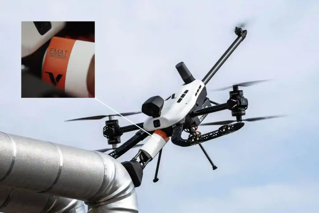
For decades, Ultrasonic Testing (UT) has been the gold standard for verifying asset integrity, yet it remains plagued by operational “friction”. Traditional piezoelectric transducers require a liquid coupling medium, such as water or gel o transmit sound waves into a material. This necessitates extensive surface preparation, including the removal of coatings, rust, and dirt, followed by a tedious cleanup of chemical residues. When these inspections occur at height, the friction multiplies. Organizations must invest heavily in scaffolding or rope access, exposing personnel to high-risk environments while assets remain offline. The Voliro T changes this equation by bringing EMAT (Electromagnetic Acoustic Transducer) technology to the sky, offering the first truly “dry” high-precision NDT solution. The Science of “Touchless” Sound EMAT represents a fundamental shift in how we generate ultrasonic waves. Unlike traditional UT, which relies on mechanical vibrations from a probe, EMAT induces sound waves directly within the metal surface of the asset. The Lorentz Force: The transducer uses a combination of a static magnetic field and a high-frequency alternating current in a coil to trigger the “Lorentz Force” within the material’s surface. Dry Inspections: Because the sound is generated inside the material, no liquid couplant or mechanical coupling is required. Resilience to Contaminants: EMAT thrives on rough, greasy, or oxidized surfaces where traditional gel-based UT would fail. Coating Penetration: The technology can measure wall thickness through existing protective coatings, eliminating the need for abrasive stripping. High-Temperature Performance: EMAT is ideal for inspecting heated assets where standard couplants would instantly boil or evaporate. Technical Synergy of the Voliro T Payload The Voliro T EMAT payload is engineered to deliver laboratory-grade data in the harshest industrial conditions. Precision Specs: The system operates at a high frequency of 3.5–4 MHz, providing a resolution of 0.06 mm. Measurement Range: It accurately measures wall thickness from 2 mm to 150 mm. Operational Flexibility: The probe supports Echo-to-Echo, Single-Echo, and Auto Thickness modes to suit various metallurgical conditions. Lift-off Capability: The sensor maintains a stable signal with a maximum lift-off of 4 mm, allowing it to work over rough textures or thin coatings. Active Contact: Utilizing the Voliro T’s 6-DoF flight architecture, the drone applies stable force to ensure the 30 mm diameter probe remains perfectly positioned against the asset. The Economics of Aerial EMAT Transitioning to an aerial EMAT workflow isn’t just a technical upgrade; it is a massive financial optimization. 4X Faster Results: While manual NDT is slow and labor-intensive, the Voliro T can collect 50–100 high-precision readings per hour. Significant ROI: Case studies indicate that aerial EMAT can save operators over $150,000 per inspection by eliminating scaffolding and minimizing asset downtime. Zero Residue: Because it is a dry process, there is no chemical cleanup required after the flight, protecting sensitive assets from couplant-induced corrosion. Enhanced Safety: The drone removes personnel from hazardous heights, “hot” zones, and toxic environments, conducting the entire survey from the safety of the ground. Implementing the Dry NDT Strategy From elevated flare stacks and large storage tanks to small suppression rings and angled pipeline sections, the Voliro T EMAT system provides a scalable, compliant solution for the digital age. With live A-Scan visualization and immediate data syncing, your engineering team can make structural decisions in real-time. Contact us and architect your autonomous future today. Let us audit your site requirements and deploy the Voliro T EMAT ecosystem wherever you are.
Voliro T: Redefining Structural Integrity Inspections through Aerial NDT
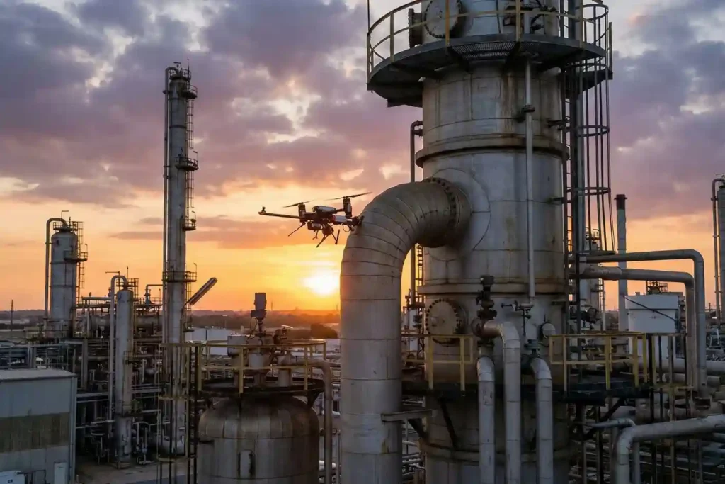
For years, industrial drones have been celebrated as the “eyes in the sky,” providing invaluable visual and thermal data from a safe distance. However, for asset integrity managers, a significant “last mile” remained: the inability to perform physical, contact-based testing without expensive scaffolding, risky rope access, or heavy machinery. Enter the Voliro T. This is not just another drone; it is an advanced aerial robotics platform designed to touch, push, and interact with the world. By bridging the gap between remote sensing and physical interaction, the Voliro T allows organizations to perform complex Non-Destructive Testing (NDT) on live assets with unprecedented speed and safety. A Masterclass in Robotic Agility The technical superiority of the Voliro T is not merely a result of its flight capabilities, but rather its specialized architecture as a 6-degrees-of-freedom (6-DoF) aerial robot. While conventional drones are under-actuated, meaning they must tilt their entire body to move laterally the Voliro T utilizes a unique vectoring thrust system that decouples its orientation from its position. This allows the platform to maintain a specific pose in space while simultaneously applying force, a requirement for high-fidelity NDT data acquisition. Stable Contact and Interaction Mechanics: The platform’s unique design features six tiltable rotors that can vector thrust in any direction. This configuration allows the drone to apply up to 30 N of stable, continuous force against a structure while maintaining a steady flight position. Beyond linear force, the system can generate several N m of torque, enabling the sensor to “seat” itself firmly against curved or irregular surfaces to ensure proper coupling for ultrasonic signals. True 360° Omnidirectional Mobility: The Voliro T is capable of interacting with structures at any angle: vertical walls, horizontal ceilings, or even the undersides of complex industrial geometries. This omnidirectional freedom allows the drone to remain “stuck” to a surface while the airframe itself rotates to avoid obstacles or adjust for shifting wind conditions. Operators can transition from a standard horizontal flight to a vertical “wall-climbing” mode without losing the active sensor link. Assisted Autonomy and GPS-Denied Operations: The Voliro T is equipped with sophisticated assisted autonomy that simplifies the process of making contact with an asset. Automated flight modes handle the precision required for the “approach and touch” phase, reducing the cognitive load on the pilot during high-stakes inspections. These systems are designed to function reliably in GPS-denied environments, such as inside large storage tanks, under steel bridge decks, or within boiler rooms, where traditional satellite-dependent drones would fail to maintain stability. Unmatched Versatility via Open Platform Design: The system is built as an open platform, featuring an interchangeable payload interface that allows for rapid field transitions between various NDT methods. Specific payload designs, such as the 33 cm long EMAT or the 32 cm long UT units, are balanced to work in harmony with the drone’s center of gravity. This versatility ensures that a single flight mission can be reconfigured for different inspection objectives, from screening for relative material loss with PEC to measuring absolute wall thickness with EMAT. The Payloads: Structural Intelligence Delivered Ground-truth data isn’t just a buzzword in 2026; it is a millimetric reality. The Voliro T ecosystem moves beyond simple photography, utilizing a sophisticated suite of swappable payloads designed for specific metallurgical and structural challenges. By integrating these sensors with the platform’s ability to apply $30~N$ of stable force, you gain access to laboratory-grade NDT data from the air. 1. Acoustic & Ultrasonic Intelligence: EMAT vs. UT While both payloads measure wall thickness, their technical applications differ based on the surface condition and the need for speed. EMAT (Electromagnetic Acoustic Transducer): * This 33 cm payload is the “dry-scan” champion, utilizing radially polarized shear waves to measure thickness without any liquid couplant. Operating at a frequency of 3.5–4 MHz, it provides a resolution of $0.06~mm$ across a thickness range of $2–150 mm. Compliant with ASTM E1816-18, it supports Echo-to-Echo, Single-Echo, and Auto Thickness measurement modes, with data visualized via a live A-Scan in the Voliro App. Ultrasonic Transducer (UT) Standard & High-Temp: The standard UT payload uses compression waves and a water-based gel couplant to deliver precision measurements compliant with EN 12668-1 and ISO 16831:2012. For active assets, the High-Temperature UT variant is a mission-critical tool, capable of operating in environments ranging from 0 °C to 260 °C (32–500 °F). Both UT versions feature a 5 MHz dual-element transducer and a natural focus depth of $10 mm, ideal for detecting internal corrosion or erosion in steel structures. 2. Surface Integrity: DFT & PEC Understanding the “skin” of an asset is just as vital as knowing its internal thickness. Dry Film Thickness (DFT): This ultra-lightweight (0.27 kg) payload uses two distinct technical methods: magnetic induction for coating thickness on ferrous metals and eddy current for non-ferrous metals. It offers a measurement range of up to 1.5 mm (60 mils) on ferrous surfaces and is compliant with a massive array of international standards, including ISO 2178, 2360, 2808, and ASTM D 7091. Pulsed Eddy Current (PEC) Sensor: The PEC payload is a powerful screening tool that measures relative volumetric material loss without direct metal contact. It is uniquely capable of measuring through non-ferrous materials such as insulation (rock-wool, blankets), fireproofing, and even marine growth or seawater. With a maximum liftoff of 100 mm, it provides an average wall thickness reading representative of its footprint, making it the perfect tool for identifying “hidden” corrosion under insulation (CUI). 3. Electrical & Wind Infrastructure: The LPS Tester Specifically engineered for the wind energy sector, the LPS (Lightning Protection System) payload ensures turbine blades can survive the elements. Wind Turbine LPS Tester: This system performs 4-wire resistance measurements (Kelvin sensing) to evaluate the full-circuit integrity of a turbine’s lightning protection. The setup includes an 820 ft (250 m) tether cable, allowing for inspections up to a maximum height of 250 m AGL. Compliant with IEC/EN 61400-24, the onboard Mostec micro-ohmmeter provides a resolution of 0.01 MΩ and can measure resistances ranging from 0.001 to 1000
How the FJD Trion V10i Redefines Centimeter Precision
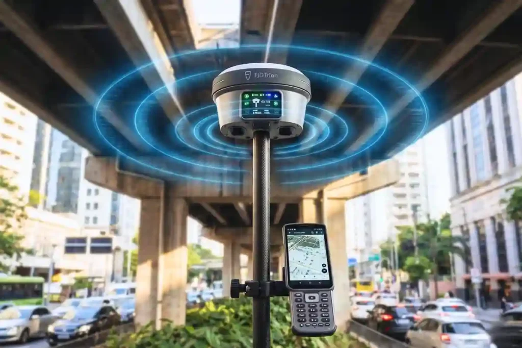
In 2026, the margin for error in industrial surveying has effectively vanished. As we move toward a world of autonomous site governance and high-fidelity digital twins, the 1–2 centimeter accuracy range has transitioned from a specialized requirement to the baseline standard for every project. However, achieving this level of precision is rarely a “plug-and-play” affair. Urban canyons with skyscraper-induced signal multipath, dense foliage that chokes satellite visibility, and dangerous, unreachable points like deep trenches or high-traffic intersections have historically degraded GNSS performance. The FJD Trion V10i breaks these barriers. By fusing 1408-channel satellite tracking with a high-speed IMU and dual-camera visual positioning, it maintains a centimeter-level “Fix” where traditional receivers find only frustration. The Technical Pillars of V10i Accuracy To achieve millimetric precision, the V10i relies on a multi-engine architecture that cross-references satellite data, inertial movement, and visual geometry in real-time. 1. 1408-Channel Multi-Constellation Tracking At the heart of the V10i is a massive 1408-channel GNSS board. While older receivers might track a dozen satellites, the V10i maintains a locked connection with every major global constellation simultaneously: GPS, GLONASS, Galileo, BeiDou, QZSS, and IRNSS. Fast Fix Initialization: This dense satellite coverage allows for a “Cold Start” fix in under 5 seconds, ensuring your team is productive the moment they step onto the site. Interference Mitigation: Utilizing advanced signal processing often powered by the Septentrio Mosaic-X5 chipset. The V10i filters out atmospheric noise and electronic interference, maintaining a stable horizontal accuracy of 8mm + 1ppm. 2. Calibration-Free IMU Tilt Compensation The physics of the V10i allows for a “tilt and go” workflow. Traditional surveying requires the pole to be perfectly vertical (leveling the bubble), which is slow and prone to human error. The 60° Advantage: The V10i’s integration compensates for pole angles up to 60° while maintaining a positioning accuracy of 3 cm. No Manual Leveling: This allows surveyors to measure the corners of buildings, utility foundations, or the bottom of slopes without needing to stand directly over the point or maintain a perfect vertical. 3. Visual Measure: The Eye of Precision The most distinct technical leap of the V10i is its dual-camera system. Dual Global Shutter Cameras: Featuring a 2MP and 5MP camera array, the V10i performs Visual Surveying. By clicking a photo on the controller, the system uses “Vision-Inertial-GNSS” fusion to triangulate coordinates. 3–5 cm Remote Accuracy: This allows for the capture of points that are physically unreachable or dangerous, such as a manhole in the middle of a highway or a point across a river with survey-grade precision from up to several meters away. Optimizing the Workflow for Maximum Precision Centimeter accuracy is not just about the hardware; it is about the “Digital Handshake” between the field and the office. AR Stakeout: Efficiency Reimagined Traditional staking involves “hunting” for a point by following directional arrows. The V10i’s AR (Augmented Reality) stakeout overlays the target point directly onto the live video feed of your controller. This visual guidance allows operators to reach the exact coordinate up to 5X faster than traditional methods, with millimetric precision upon arrival. Site Setup and Correction Links To maintain that 8mm horizontal accuracy, the V10i provides flexible correction options: Internal UHF Radio: For remote sites (5–8 km range) where cellular signals are non-existent. Network RTK (NTRIP): For urban agility, connecting via 4G to existing base station networks for instant corrections. Data Integrity through the Trion Cloud Every coordinate logged is instantly synced to the trion survey cloud. This ensures that your high-precision data is backed up and available for immediate engineering review, preventing the “data silos” that often lead to project rework. Deploying the Precision Revolution The FJD Trion V10i is more than a receiver; it is a gateway to the autonomous site. By combining visual intelligence with 1408-channel reliability, it allows your team to perform at a level of speed and accuracy that was previously impossible. Architect your autonomous future. Contact us today to audit your site requirements and show you, wherever you are, how the FJD Trion RTK ecosystem will bridge your precision and labor gap for 2026.
FJD Trion Series: The GNSS Ecosystem for Every Operational Frontier
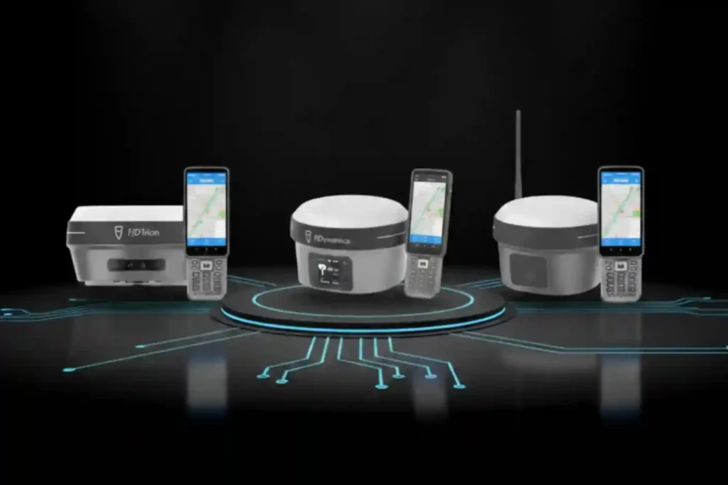
In 2026, centimeter-level accuracy is no longer a luxury, it is the prerequisite for the modern industrial site. Whether automating a tractor for row-crop optimization, guiding an excavator on a complex construction project, or deploying autonomous robotic mowers, high-precision geospatial data serves as the invisible backbone of efficiency. However, the modern operational environment is multi-faceted. A remote agricultural field with zero cellular coverage presents entirely different challenges than an urban construction site where skyscrapers block satellite signals. To solve these specific geospatial barriers, the FJD Trion V10 Series provides three distinct, high-performance GNSS RTK receivers: the V10L, the V10i, and the V10a. Three Tools, One Ecosystem (Functions & Differences) To understand the strategic value of the FJD Trion V10 Series, it is essential to look under the hood of each receiver’s specific hardware and communication protocols. While all three share a common mission of high-precision data acquisition, their technical architectures are optimized for different operational frontiers. 1. FJD Trion V10L: The Agile Network Specialist The V10L is the minimalist powerhouse of the lineup, stripped of bulky internal radios to favor a sleek, ultra-portable form factor without compromising on surveying standards. Network-First Architecture: Unlike traditional receivers that require a heavy Base-and-Rover UHF radio setup, the V10L is built primarily as a Network Rover. It leverages an internal high-gain 4G module to connect directly to CORS (Continuously Operating Reference Stations) via the NTRIP protocol. This allows the surveyor to achieve a “Fix” in seconds using only the rover and a handheld controller. Optimal Use Case: City-wide utility mapping, municipal infrastructure audits, and landscape planning in areas where cellular signal is ubiquitous. Technical Differentiator: It is the lightest in the series, reducing operator fatigue during 8-hour field shifts, yet it still tracks GPS (L1/L2/L5) and BeiDou (B1/B2/B3) with the same millimetric sensitivity as its larger siblings. 2. FJD Trion V10i: The Visual Intelligence Powerhouse The V10i represents the pinnacle of “Visual-Inertial-GNSS” fusion, adding a literal eye to the receiver to solve the industry’s oldest problem: “The Blind Spot”. Integrated HD Vision: The base of the V10i houses a high-definition, low-light camera. This is not just for photography; it powers AR (Augmented Reality) stakeout and visual surveying. In the field, the operator can see the target points overlaid on a live video feed on their controller, making staking tasks significantly more intuitive. Measure-from-Distance Capability: The most profound technical advantage of the V10i is its ability to measure points without physical contact. By leveraging Vision-Inertial-GNSS fusion, the software can triangulate coordinates from the camera feed. This means a surveyor can stand 5 meters away from a busy highway lane or a deep construction trench and accurately log a point that would otherwise be dangerous or impossible to reach with a pole. Technical Differentiator: It bridges the gap between GNSS and photogrammetry, maintaining precision even when multi-path interference (signals bouncing off tall glass buildings) would typically cause a standard receiver to lose its “Fix”. 3. FJD Trion V10a: The Heavy-Duty, All-Around Performer The V10a is the “Alpha” tool in the lineup, designed for total autonomy from external infrastructure. Dual-Communication Capability: While it supports Network RTK like the V10L, the V10a features a powerful internal UHF radio (transmitter/receiver). This allows it to act as either a base station or a long-range rover. In environments with zero cellular coverage, such as deep desert oilfields or remote agricultural valleys, the V10a establishes its own 5km to 10km “data link” to provide corrections to other machinery. Interference Resistance: Built into the V10a are advanced anti-jamming and multi-path suppression algorithms. This makes it the standard for “dirty” signal environments like massive construction sites filled with heavy metal machinery and radio interference from other site teams. Technical Differentiator: Its ruggedized shell and high-capacity battery are built for “Frontier Work,” where charging points are rare and the environment is harsh. It is the definitive choice for integrated site backbone roles, providing a stable correction source for FJDynamics autosteer tractors and excavators. The Shared DNA of FJD Trion Reliability While the specialized functions of the V10L, V10i, and V10a provide the “personality” for specific projects, their shared engineering core provides the “reliability” that professional surveyors demand. This shared DNA is built on three technical pillars: IMU-driven tilt compensation, multi-frequency constellation tracking, and deep integration into the FJDynamics autonomous ecosystem. 1. The Math of Speed: Calibration-Free IMU Tilt Compensation One of the most significant bottlenecks in traditional surveying is the “leveling phase,” the seconds spent ensuring the carbon fiber pole is perfectly vertical before a point can be logged. The FJD Trion series eliminates this entirely through a high-grade Inertial Measurement Unit (IMU). Real-Time Vector Calculation: The integrated IMU continuously tracks the receiver’s orientation, pitch, and roll at high refresh rates. It uses complex algorithms to calculate the exact distance between the antenna’s phase center and the tip of the pole, regardless of the angle. 60° Operational Freedom: Field operators can capture accurate, survey-grade points even when the pole is tilted at up to 60°. This is critical when measuring corners of buildings, utility poles, or the edges of deep excavation pits where standing directly over the point is impossible or unsafe. Calibration-Free Readiness: Unlike older generations of tilt-compensated GNSS, the Trion series is “initialization-free”. The IMU stays active and calibrated while the operator walks, allowing for immediate point capture the moment the pole tip touches the ground. 2. Multi-Frequency “Fast Fix” Constellation Tracking In the industrial environments of 2026, signal reliability is the difference between a productive day and an expensive delay. The Trion series features a 1408-channel GNSS board capable of simultaneous tracking across all global navigation constellations. Total Frequency Coverage: The receivers track GPS (L1/L2/L5), GLONASS (G1/G2/G3), BeiDou (B1/B2/B3), Galileo (E1/E5a/E5b), and QZSS (L1/L2/L5). Rapid Cold-Start Performance: By tracking more satellites than standard receivers (typically 30+ visible at any time), the Trion series achieves a “Fix” in under 10 seconds, even in challenging environments like deep urban canyons. Signal Reconstruction Technology: Advanced algorithms work to filter out “multi-path” signals, erroneous data