Establishing massive urban complexes in hyper-arid desert environments requires absolute spatial precision right from the start.
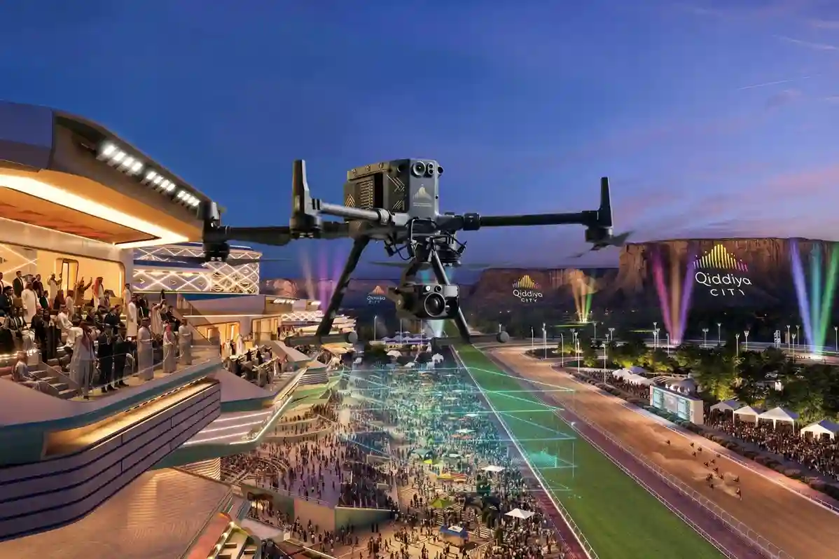
The Qiddiya City master plan spans over 360 to 376 square kilometers, which will comprise multiple districts, including 43 separate sports facilities.
Developing on this scale requires robust civil engineering frameworks to handle massive human populations.
Once fully operational, the city is designed to support and attract 48 million visits annually by 2030, which will place a massive ongoing strain on the area’s localized utility and medical infrastructure.
To build highly efficient public infrastructure of this size, civil engineers and developers cannot rely on traditional, manual ground surveying, which slows down initial development pipelines.
Instead, engineering teams must deploy advanced aerial diagnostic workflows before any physical construction begins.
Managing Extreme Thermal Loads in Saudi Desert Developments
A key milestone for the city’s healthcare and athletic network occurred recently.
The sports medical center agreement between Qiddiya Investment Company (QIC) and King Faisal Specialist Hospital & Research Centre (KFSH&RC) was officially finalized in April 2026.
Planning an advanced medical facility of this scale requires strict environmental data because the physical environment introduces severe thermal challenges.
Developers must understand exactly how raw desert terrain absorbs and radiates heat before starting any physical construction.
The Strategic Blueprint for Specialized Infrastructure
Medical facilities housing advanced diagnostic machinery and patient recovery wards have zero tolerance for internal temperature fluctuations.
When athletes train and undergo physical rehabilitation, subtle microclimate variations across the site directly impact their therapeutic outcomes.
The geographical reality of the Gulf means ambient air temperatures regularly surpass 45°C during peak summer months.
Designing large physical structures in this landscape demands a complete shift from reactive mechanical cooling to preventative architectural planning.
Civil engineers must map how the raw earth retains heat before laying down concrete foundations or utility networks.
Failure to evaluate these thermal baselines risks creating localized heat traps that jeopardize both sensitive medical assets and patient wellness zones.
Evaluating the National Energy Footprint
Designing massive public projects without advanced climate modeling creates a long-term economic drain on municipal power grids.
Data shows that the broader building construction sector in the Kingdom of Saudi Arabia (KSA) consumes roughly 75% of the country’s total electrical energy.
This immense energy footprint is tied directly to the baseline climate conditions of the region.
Peak electricity demand across the Kingdom spikes severely during the summer season, driven directly by continuous air conditioning use.
When massive structures are built on unmapped desert plots, HVAC systems must run at maximum capacity to override external thermal stress.
This constant strain shortens equipment lifespans and inflates operational budgets significantly over time.
By mapping the site’s unique heat retention patterns early, project managers can alter building shapes to reduce direct solar exposure.
This preventative action significantly reduces the baseline cooling infrastructure needed to maintain stable indoor temperatures.
Overcoming the Building Insulation Deficit
The ongoing reliance on heavy mechanical cooling is tied closely to how regional structures were historically developed.
Industrial research indicates that up to 70% of existing buildings in Saudi Arabia lack sufficient thermal insulation.
This structural insulation deficit means historical properties allow external heat to pass easily into interior spaces, driving up power consumption.
To break this cycle, modern megaprojects must utilize advanced data streams to design highly optimized external envelopes.
This reality makes pre-construction microclimate tracking and aerial heat mapping essential for new projects to optimize building materials and HVAC positions before foundations are poured.
Airborne thermal sensors record exact surface radiation values that tell engineers how different soil types and rock formations store heat.
Planners use these data layers to select the correct insulation ratings for different walls of the medical center.
This targeted material placement ensures the facility acts as a natural shield against extreme desert heat waves.
Deploying Precision Aerial Intelligence Before Groundbreak
Executing a comprehensive site assessment across large desert plots requires rapid, high-resolution data collection methods.
This aerial intelligence is particularly vital when managing massive infrastructure footprints, such as the 360 to 376 square kilometers master plan area of Qiddiya City.
Deploying a low-altitude enterprise drone like the DJI Matrice 400 (M400) allows survey crews to map expansive coordinates in a single flight day.
This workflow completely replaces weeks of hazardous manual ground treks across rugged rock canyons and steep desert valleys.
The resulting high-resolution orthomosaic maps provide absolute geographic clarity across the unbuilt landscape.
These precise digital maps serve as the foundational baseline for initial architectural drafts and staging zone layouts.
Advanced Terrain Modeling and Precise Layout Mapping
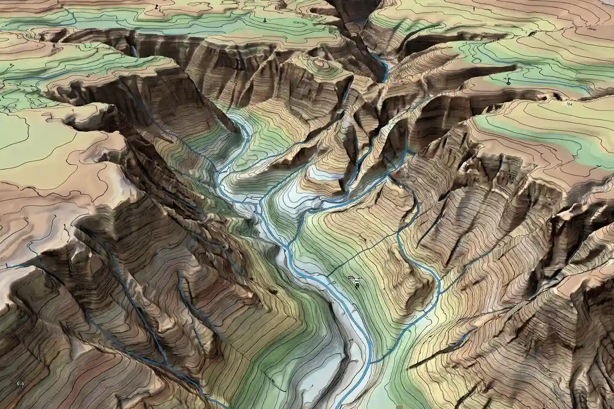
To build robust foundations, civil engineers must understand the exact physical contour changes across the unbuilt plot.
The DJI Matrice 400 equipped with the Zenmuse H30T payload utilizes its high-resolution visual sensors to capture overlapping aerial imagery, generating detailed terrain modeling files.
These digital models allow development teams to visualize three-dimensional slope variances and steep elevation changes across the site.
This geometric data enables precise layout mapping for critical infrastructure components, such as main access roads and underground utility lines.
Additionally, mapping the exact elevations allows planners to calculate natural water drainage pathways across the desert floor.
Identifying these flash-flood runoff zones ensures that engineers can plan proper drainage networks before pouring heavy concrete foundations.
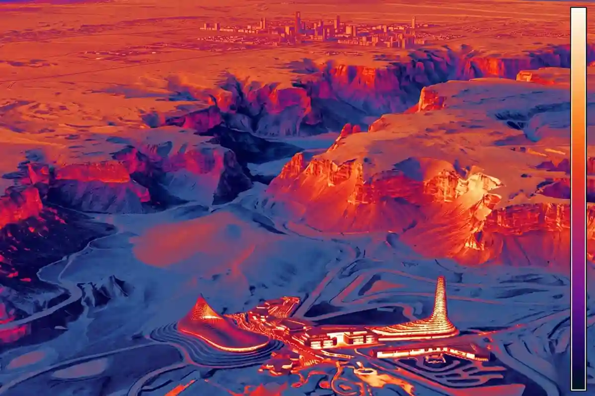
Aerial Thermal Mapping and Microclimate Diagnostics
Beyond mapping visible land structures, developers must understand how the local environment retains and radiates heat.
Deploying the DJI Matrice 400 with the Zenmuse H30T radiometric thermal sensor allows engineers to perform comprehensive thermal mapping across the unbuilt terrain.
These advanced sensors record exact surface radiation values across varied soil types and desert rock formations.
The resulting data highlights specific geographical sections that act as natural heat traps during peak summer days.
Planners use these microclimate diagnostics to identify localized thermal stress zones before breaking ground.
This allows engineers to optimize the building’s future insulation boundaries and position mechanical HVAC networks away from high-heat zones.
Streamlining Pre-Construction Workflows through BIM Integration
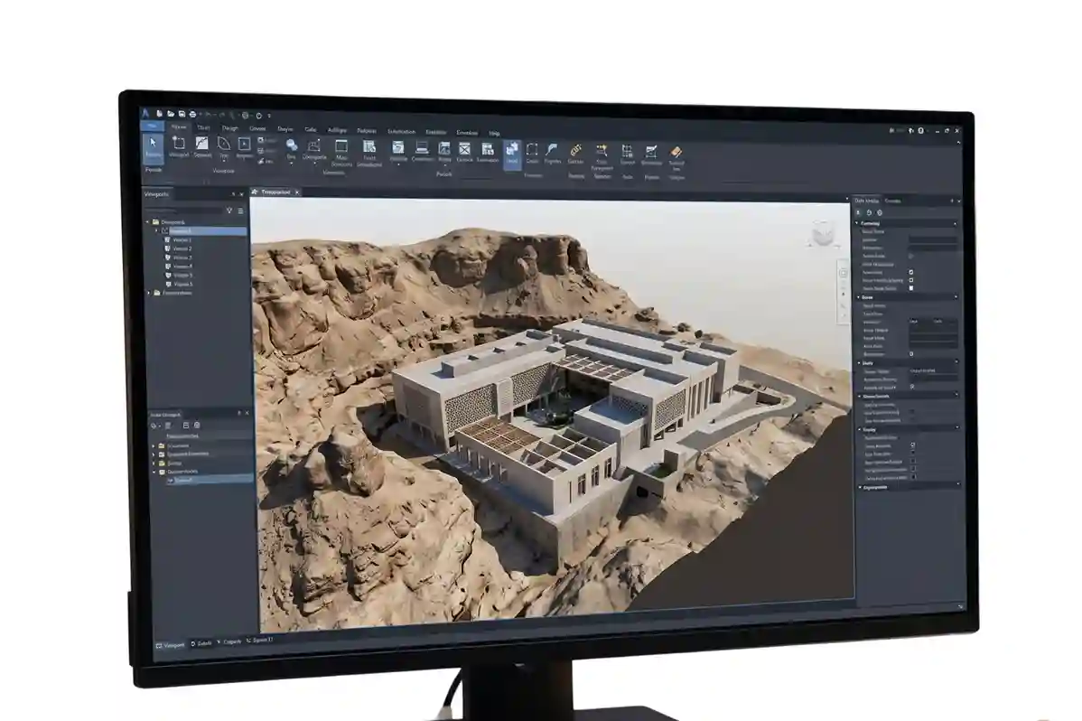
To maximize the utility of these aerial datasets, the physical and thermal models must combine into a single engineering file.
This consolidated digital information merges directly into advanced design software for automated bim integration.
This digital twin approach ensures that the final structural blueprints completely match the real-world environmental properties of the plot.
Architects can then alter building orientations to reduce direct solar exposure and minimize long-term utility strain.
Consequently, project managers can identify and correct design discrepancies before heavy construction equipment arrives on-site.
This proactive data integration shortens construction timelines and eliminates expensive structural changes during active building phases.
Optimize Your Pre-Construction Workflow
Do not rely on historical data or slow ground surveys when starting complex development projects in Qiddiya city.
Integrating automated drone services into your initial design phase prevents expensive structural corrections, lowers future HVAC energy costs, and shortens construction timelines.
Utilizing advanced aerial analytics before pouring foundations ensures your project meets modern efficiency targets.
Contact our expert to deploy early site mapping assets for your next construction.

