Riyadh’s extreme summer heat creates severe thermal stress, making massive urban forestry projects a critical challenge for local engineering teams.
To combat this harsh climate baseline, the Green Riyadh initiative spans 545 square kilometers with a mandate to plant 7.5 million native, drought-resistant trees across the capital by 2030.
According to environmental impact data, this intensive urban afforestation drops surface heat reflection by 8°C to 15°C and lowers ambient air temperatures by up to 15°C through active shade and moisture release.
Furthermore, successfully lowering the city’s ambient temperature is projected to cut municipal energy consumption by 650 gigawatt-hours annually due to a massive reduction in air conditioning demands.
Despite these clear benefits, keeping millions of young saplings alive during peak summer remains a massive operational hurdle.
Manually sending ground crews or pilot-operated drones across a 545-square-kilometer zone to monitor young vegetation during a 50°C summer introduces severe labor costs and safety risks.
Traditional visual ground inspections cannot spot dehydration until the damage has already occurred, leading to high plant mortality rates.
Eliminating Inspection Gaps
Waiting for visible signs like browning leaves or drooping branches is a flawed strategy for land managers.
Visible damage indicates severe, irreversible cellular breakdown that makes plant recovery highly unlikely.
Human eyes can only see light in the visible spectrum, leaving asset managers completely blind to the early stages of crop dehydration occurring within the plant’s internal tissues.
Fortunately, advanced automated mapping sensors can detect biophysical plant changes and water shortages 2 to 7 days before any visual symptoms (such as drooping, yellowing, or leaf browning) are visible to the human eye.
This early detection window allows municipal landscaping teams to intervene with targeted irrigation while the root systems are still healthy enough to recover fully.
Biological studies show the exact mechanism behind this invisible stress window:
- When a tree sapling experiences water stress, it immediately closes its stomata to trap moisture.
- This protective measure slows down plant transpiration.
- The drop in transpiration causes its canopy temperature to spike immediately, providing a clear data signature before the plant actually dies.
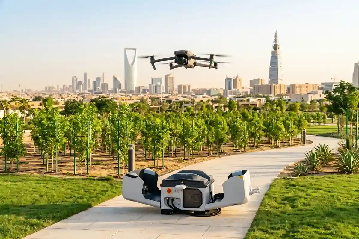
Deploying a weatherproof automated station like the DJI Dock 3 allows the system to launch automated flights on a rigorous daily schedule without an on-site operator.
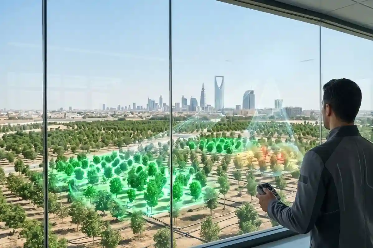
This persistent aerial presence captures these critical heat signatures at regular intervals, turning urban forestry from a reactive guessing game into a precise, predictive science.
Continuous Crop Monitoring Anywhere, Anytime
To bridge the operational gaps of manual field surveying, municipal teams replace slow ground checks with automated flight operations.
Programmed flights launch directly from the dock, allowing the aircraft to systematically cover extensive acreage of municipal green spaces in a single cruise.
This speed allows city managers to scan entire urban sectors on a regular weekly schedule, ensuring that no pocket of vegetation goes unmonitored during the hottest months of the year.
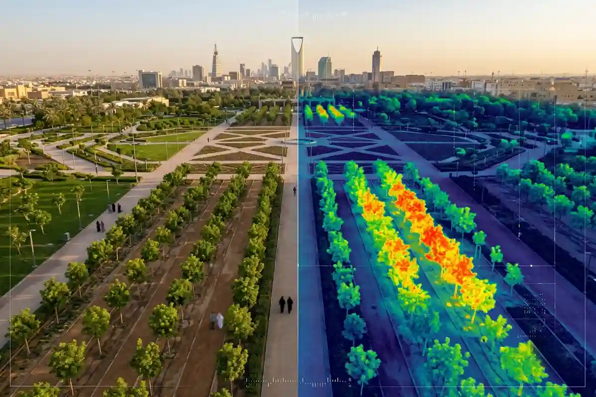
During these automated flights, the docked Matrice 4TD drone utilizes a high-resolution thermal and visual sensor array to look past visual limits, giving engineers a standardized tool for continuous crop monitoring.
While the standard visual camera records a familiar high-resolution photographic view of the park, the thermal channel isolates the exact heat anomalies produced by cellular water stress.
The resulting high-fidelity aerial maps reveal exact temperature anomalies over the canopy, showing civil engineers precisely where underground drip irrigation tubes are blocked or leaking.
If the thermal data shows a straight line of elevated tree temperatures winding through a park, technicians know immediately that an irrigation line has failed.
This targeted data allows cities to deploy maintenance crews to the exact spot of the failure, eliminating water waste while keeping the urban canopy alive.
Additionally, the DJI Dock 3 introduces vital flexibility for sprawling mega-projects.
Thanks to its vehicle-mounted deployment design, municipal maintenance teams can move the entire docking station via truck to different sectors of the capital as planting zones expand, maximizing hardware utility across the entire city.
Secure Your Environmental Infrastructure
Don’t wait for extreme summer weather to cause widespread losses across your newly planted green assets.
Consult with our expert and don’t wait for trees to turn brown before taking action introduces unnecessary financial and ecological risk to large-scale municipal developments.

