Securing Marine Assets with ROV Inspection and Subsea NDT.
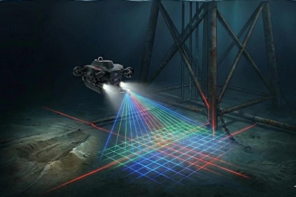
While the world marvels at the soaring skyscrapers of Riyadh and the mirrored walls of NEOM, a second, equally ambitious infrastructure revolution is taking place beneath the waves. Saudi Arabia’s maritime infrastructure, spanning the Red Sea and the Arabian Gulf is home to a vast, invisible network of subsea lifelines, including oil and gas pipelines, high-voltage power cables, and critical communication links. However, this underwater world is a hostile environment. In these harsh maritime zones, infrastructure faces constant threats from aggressive saltwater corrosion, intense pressure, and biofouling. Traditional manual diving, while historically necessary, cannot keep pace with the scale of Vision 2030’s coastal giga-projects. It is slow, limited by depth, and carries high physical risk to personnel. The high cost of failure in these zones, ranging from environmental disasters to billion-dollar energy shutdowns demands a technological shift. The transition from human-led diving to subsea robotics in Saudi Arabia is no longer just an upgrade; it is an essential requirement for the long-term integrity of the Kingdom’s offshore and coastal assets. The Technology of the Deep The core of this revolution is the Remotely Operated Vehicle (ROV). These inspection-class robots act as the eyes and hands of engineers in environments where humans simply should not go. From Divers to ROVs: Unlike human divers, ROVs can operate 24/7 at depths exceeding hundreds of meters, unaffected by the physiological limits of pressure or oxygen. Advanced Sensing and Vision: Modern ROVs utilize high-definition visual imaging and multibeam sonar to navigate and “see” even in the silty, low-visibility conditions of the seabed. Quantitative Corrosion Mapping: Specialized ROVs are equipped with Ultrasonic Thickness (UT) gauges and cathodic protection (CP) probes. These tools allow for precise, contact-based measurements of metal thickness and electrical potential, identifying thinning pipe walls long before a leak occurs. Integrated Frameworks: Terra Drone Arabia (TDSA) has pioneered a unified framework that merges subsea ROV data with aerial UAV and terrestrial scans. This provides asset owners with a single, holistic view of their infrastructure from the seabed to the sky. Securing Coastal and Offshore Assets The deployment of subsea robotics in Saudi Arabia serves as the primary defense for the Kingdom’s most valuable maritime investments. Offshore Oil & Gas Integrity: Routine monitoring of platform jackets, risers, and subsea production systems is vital. ROVs detect structural fatigue and weld defects early, ensuring compliance with global safety standards and preventing catastrophic failures in the Arabian Gulf. Coastal Giga-Projects (NEOM & The Red Sea): As the Red Sea project and NEOM expand, maintaining the integrity of underwater jetties, desalination intakes, and luxury coastal structures is paramount. ROVs monitor these assets while simultaneously conducting environmental surveys to protect the Kingdom’s precious coral reefs. Data-Driven Longevity: Every dive generates a digital trail. By building Digital Twins from ROV data, engineers can perform predictive maintenance. This allows operators to simulate structural degradation and extend the lifespan of multi-billion dollar assets through precisely timed interventions. Diving into the Digital Future The future of marine asset management in the Kingdom is undeniably robotic. The precision, safety, and scalability offered by subsea robotics in Saudi Arabia provide the foundation for the next decade of maritime development. Terra Drone Arabia is leading this transition, bringing global robotic expertise to the Kingdom’s local shores. We integrate cutting-edge ROV technology with advanced data analytics to ensure your subsea assets remain secure and compliant. Don’t complex your underwater inspection. Contact us for your marine infrastructure and experience the certainty of digital subsea integrity.
The 2025 Recap from Terra Drone Arabia
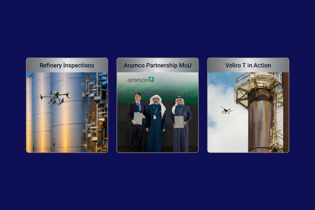
As the curtain falls on 2025, the industrial landscape of Saudi Arabia stands fundamentally altered. What was once a horizon dominated by traditional manual labor and terrestrial surveying has transitioned into a high-velocity, data-driven domain known as the Low Altitude Economy (LAE). At the heart of this revolution is Terra Drone Arabia (TDSA). This Terra Drone Arabia 2025 recap serves not just as a history of the past twelve months, but as a roadmap for how unmanned aerial systems (UAS) have become the bedrock of the Kingdom’s industrial. Throughout 2025, TDSA moved beyond the role of a simple service provider to become a strategic architect of the Saudi digital ecosystem. From the deep shafts of mineral exploration in the Hijaz mountains to the complex flare stacks of Eastern Province refineries, Terra Drone’s influence was ubiquitous. It was a year defined by three core pillars: localization, technical integration, and a relentless commitment to the goals of Saudi Vision. Q1: Localization and Standardization The year began with an aggressive focus on two sectors critical to the Kingdom’s diversification: energy and mining. In January, TDSA demonstrated its deep-rooted commitment to the Saudi workforce and supply chain at the 10th iktva Forum & Exhibition 2025. This event served as a public declaration that TDSA is not just operating in Saudi Arabia; it is of Saudi Arabia, focusing on local talent development and technological sovereignty. Simultaneously, the Future Minerals Forum 2025 showcased how drone solutions are no longer “optional extras” but are now the new industry standard in mining. By integrating satellite imagery with modern mining workflows, TDSA enabled explorations to move at a pace previously thought impossible, achieving results up to eight times faster than conventional. February shifted the focus toward the “City of the Future.” At the Al Ahsa Forum, TDSA unveiled how smart city drones are essential for the urban development of the East. The narrative of February was one of “Smart Urbanism,” where UAVs are used not just for mapping, but as the sensory nervous system of emerging smart. Q2: Strategic MoUs and Educational Initiatives If Q1 was about showcasing technology, Q2 was about institutionalizing it. March and April were dominated by a historic milestone: Terra Drone signing a Memorandum of Understanding (MoU) with Saudi Arabia. This agreement was a seismic shift in the regional tech landscape, designed to drive innovation and localization in drone technology specifically for the global energy. However, innovation is useless without a skilled workforce to operate it. In May, TDSA and the ITQAN Institute signed an MoU to launch specialized drone inspection training. This initiative ensured that the next generation of Saudi engineers is equipped to handle advanced assets like the Voliro T, a drone capable of performing Non-Destructive Testing (NDT) at heights, potentially saving operators millions in. By the end of the quarter, the conversation moved toward ESG (Environmental, Social, and Governance) excellence. TDSA began advocating for drone monitoring as the “fast-track” to achieving safety and environmental goals, emphasizing that a digitized asset is a safer and more sustainable. Q3: Scaling Infrastructure and Global Distribution As the summer months arrived, the scale of operations reached new heights. June and July saw TDSA positioning drones as a core pillar of Vision 2030’s infrastructure. The company proved that aerial surveillance could save up to 95% of traditional costs in large-scale monitoring. A major highlight of this period was the global rollout of the Terra Xross 1, a Japan-made indoor inspection. Through distribution agreements with partners in Taiwan, Chile, and beyond, TDSA’s influence as a global hub for indoor inspection technology was. This was not merely about international sales; it was about proving that technology vetted in the harsh industrial environments of Saudi Arabia is world-class. In August, TDSA tackled the challenge of renewable energy. By utilizing drone topographic surveys, the company demonstrated a reduction in renewable energy site preparation time by up to 90%. This speed is essential for the Kingdom as it races toward its ambitious green energy targets. Furthermore, the introduction of the DJI Dock solution showed city planners how to save 30% of surveillance budgets through automation and persistent aerial presence18. Q4: The Rise of Integrated Inspection Frameworks The final months of 2025 witnessed a shift from individual drone flights to holistic asset management. In October and November, TDSA moved the goalposts by introducing an integrated aerial, terrestrial, and marine inspection. This approach acknowledges that industrial asset integrity does not end at the waterline or the ground level; it requires a unified view of the entire. One of the most technically impressive feats discussed in November was the rise of ROV-based monitoring for marine. By combining subsea ROV data with aerial UAV data, TDSA created the ultimate “Digital Twin,” a 3D roadmap for highway construction, mining, and offshore energy that allows for near-real-time decision. The year concluded with a focus on safety and compliance. TDSA’s global group company, Unifly, completed trials on collision avoidance and safe flight separation, ensuring that as the skies of Saudi Arabia become more crowded with drones, they remain. This technical groundwork is what allows for the rise of the economy under 1,000 feet, turning the sky into a productive industrial. Technical Deep Dive: The Evolution of Autonomous Systems To understand why 2025 was so successful, one must look at the specific technologies that matured during this period. UTM (Unmanned Traffic Management): TDSA emphasized that UTM systems are the primary driver of flight safety and compliance, paving the way for scalable drone operations across the Middle. BVLOS (Beyond Visual Line of Sight): The ability to fly long-distance corridors for power transmission and pipelines became a reality, improving project timelines. LiDAR and Photogrammetry Integration: By revolutionizing land surveying with integrated LiDAR, TDSA enabled topographic mapping of 124 km² in just one month, a feat that would take traditional teams years to. NDT (Non-Destructive Testing): The shift to drone-based visual and ultrasonic thickness (UT) systems revolutionized corrosion inspection, allowing for inspections of live flare stacks and storage tanks without cost. The