How Geospatial Intelligence Powers Predictive Asset Management
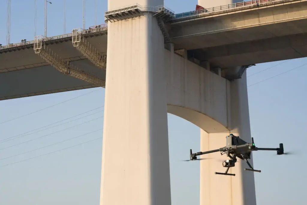
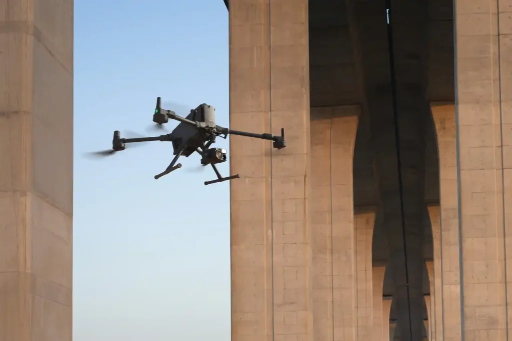
The Operational Imperative The moment infrastructure like highways, bridges, and industrial assets finish construction, they enter a critical new phase: operational risk. Managing maintenance is the single largest long-term cost, and reactive failure, waiting for a fault before fixing it is unacceptable for any modern smart city. The challenge lies in inspection. Traditional integrity checks are slow, subjective, and inherently dangerous. They require costly actions like building scaffolding or closing traffic lanes. This process delivers low-volume, outdated data, locking asset managers into a dangerous cycle of reactive failure. The only effective solution is the digital twin, a virtual replica built on persistent, high-quality data. This digital twin, fueled by geospatial intelligence for smart city data, enables the fundamental shift to safe, objective, and predictive maintenance. The Data Foundation for Asset Integrity The operational success of a highway or an industrial plant starts with the quality of its initial survey data. This information creates the digital foundation for the entire asset lifecycle. I. Establishing the Digital Baseline for RUL Calculation All reliable long-term maintenance must start with a perfect measurement of the asset’s original, healthy state. A. The Geospatial Baseline The initial centimeter-accurate survey data collected using drone-based LiDAR and Photogrammetry creates the indispensable structural health baseline. This initial data is the only reference point against which all future material wear, structural cracks, and component degradation are measured. Without this accurate baseline, calculating deterioration is impossible. B. Data Chronology for RUL The ultimate goal of asset management is accurately forecasting failure. This is done through remaining useful life (RUL) calculation. RUL Definition: The RUL predicts how much longer an asset can operate safely before maintenance or replacement is necessary. Data Necessity: Accurately calculating RUL requires a consistent, chronological data feed. Drone technology provides this through repeatable missions (weekly or monthly flights) that document changes over time. Cost Benefit: Using this predictive data allows companies to shift maintenance spending from sudden, expensive emergencies to planned, controlled projects, maximizing the useful life of the asset. Advanced Integrity Checks and Simulation The Digital Twin’s predictive power is unlocked by combining the initial baseline data with continuous, non-contact integrity checks. II. Non-Contact Integrity and Defect Detection Drones perform essential, high-risk inspections without ever endangering human personnel or halting operations. A. Structural Health Monitoring Bridge Scanning: Drones fly precise, automated flight paths beneath complex highway structures and bridges. This non-contact method eliminates the cost of scaffolding and the risk of lane closures. Visual Data: High-resolution cameras scan for tiny surface defects like concrete cracks, spalling, and corrosion. Drone inspections can reduce asset inspection times by 4 times compared to manual methods, allowing for more frequent and proactive maintenance checks. Pavement Analysis: High-resolution drone cameras collect data used to map and classify pavement damage, such as cracking and rutting. This detailed information helps transportation agencies prioritize road repairs effectively. B. Specialized Non-Destructive Testing (NDT) Advanced payloads allow for structural health checks beyond simple visual inspection. Thermal Imaging: Thermal cameras detect temperature variations on surfaces like pavements or bridge decks. These temperature differences often reveal subsurface issues like water intrusion, poor drainage, or voids beneath the roadbed that human eyes cannot see. Early thermal mapping prevents minor moisture issues from growing into major structural failures. Confined Space Safety: Using small, specialized drones, we inspect hazardous and enclosed assets like boilers, storage tank interiors, and industrial vessels. This capability eliminates human risk and minimizes costly operational shutdown time. Drone UT: Drones equipped with ultrasonic thickness (UT) probes perform non-contact measurement of material thinning and corrosion in assets like storage tanks and pipe. This provides critical input for the predictive maintenance model. C. Predictive Simulation (The Digital Twin at Work) The Digital Twin consumes all this recurring inspection data (baseline + defects) to run simulations. Forecasting Failure: The twin runs predictive models that forecast when a structural element will reach its critical threshold (RUL). This allows asset managers to schedule repairs precisely, maximizing the useful life of the asset while minimizing costly downtime. Centralized Management: This platform ensures that all parts of the future smart city operate cohesively and efficiently, confirming that the foundation of the system is robust, up-to-date Geospatial Intelligence for Smart City data. Secure Your Operational Future The digital transformation of asset management moves highway and infrastructure care from reactive to predictive, objective, and safe. The use of continuous geospatial intelligence for smart city platforms ensures that infrastructure remains durable, efficient, and compliant with long-term goals. Terra Drone Arabia is your certified local partner. We possess the needed technical capacity and local compliance knowledge to deliver comprehensive geospatial data for every inspection mission. Accelerate your shift to predictive asset management and experience these efficiency gains with FREE 3-month progress monitoring on a key bridge or highway section. Let’s talk to your future-proof critical transportation network.
Precision Mapping: The Technical Core of High-Speed Highway Design
The foundational task of building or improving any major road, rail, or highway in the swiftly developing MENA region is topographic mapping. This process, which creates a three-dimensional model of the land’s surface, is not just a preliminary step; it dictates the engineering viability, the budget, and the ultimate timeline of the entire project. Yet, the intense pressure of Vision 2030 deadlines has created a crisis: the slow, dangerous, and low-density methods of the past simply cannot keep pace. We need a solution that is not just faster, but also more accurate. The answer is the intelligent integration of advanced drone technology. The future of linear infrastructure hinges on the integrated process of aerial topographic mapping, combining LiDAR and Photogrammetry to create a perfect digital foundation for accelerated design and compliance. The Geospatial Imperative The economic stability and successful completion of giga-projects depend on fast, reliable survey data. The cost of relying on traditional methods—using manual GNSS rovers or Total Stations—is no longer acceptable. The Time-to-Data Crisis For long, linear projects like new highways, manual surveying is inherently slow and logistically complex. Low Data Density: Traditional methods rely on measuring individual, selected points3. This results in a sparse dataset that is often insufficient for the detailed volumetric and alignment checks required by modern engineering standards4. Safety and Accessibility Risks: Survey teams must be physically present on the ground, often working on steep slopes, near heavy machinery, or close to active traffic555. This introduces significant safety risks and slows work for compliance6. Design Lag: The time needed to complete a manual survey of a long corridor can lead to a severe Time-to-Data crisis7. By the time the data is processed, ground conditions may have already changed, forcing costly design adjustments or rework8. The only way forward is a solution that can capture data at a density measured in millions of points per second, safely, and from the air. Building the Perfect Digital Terrain Model (DTM) The core of highway acceleration is the shift to high-precision, non-contact data capture that guarantees accuracy for civil engineering design. This process relies entirely on a technical partnership between two sensor types. I. High-Fidelity Data Capture: The LiDAR and Photogrammetry Duo The initial phase of any highway project is critical for budget and safety9. Drones transform this process into a fully transparent, digitally integrated workflow10. A. LiDAR for True Terrain Modeling (DTM): The Geometric Foundation LiDAR systems provide the most geometrically accurate data needed for civil engineering design, especially where natural terrain is involved11. Pulse Technology and DTM: Our drone-mounted LiDAR systems are active sensors that emit millions of laser pulses per second, precisely measuring distance to create a three-dimensional point cloud12. Bare-Earth Penetration: The key technical strength is the ability to record multiple returns per laser pulse. This allows the system to effectively filter out surface features like scrub or construction debris, isolating the bare-earth Digital Terrain Model (DTM)13. This DTM is the non-negotiable geometric basis for calculating slope stability and precise road drainage14. Corridor Integrity: This data is used to define critical right-of-way boundaries and spot potential geological hazards along the lengthy highway corridor15. B. Photogrammetry for Visual Context and Textural Accuracy While LiDAR provides the geometric skeleton, photogrammetry supplies the high-resolution visual context needed for design review and documentation. Creating the Auditable Orthomosaic: Drones capture thousands of high-resolution, overlapping images that are processed into a single, seamless Orthomosaic Map16. This map is geometrically corrected and precisely aligned using RTK (Real-Time Kinematic) positioning, ensuring the visual data is just as accurate as the LiDAR geometry17171717. Subsurface Modeling: The initial survey data is also essential for integrating follow-on data, such as utility maps created through Ground Penetrating Radar (GPR)18. This provides a complete 3D picture of any existing underground utilities that could conflict with the new highway design19. Operational Value and Intelligence The speed of data capture must translate into provable efficiencies and high-quality results. This is where the integration of topographic mapping into the digital ecosystem pays off. II. Quality Control and Earthwork Efficiency During Construction The construction phase of a major highway is characterized by rapid change and high-stakes financial risk. Drones transition from initial surveyors to the project’s digital Quality Assurance (QA) engine. A. Earthwork Efficiency: Volumetrics and Digital Auditing Drones control the largest cost variables in highway construction, the movement and management of soil. Cut-and-Fill Verification: Automated drone flights capture ultra-high-density 3D data used to create digital elevation models (DEMs). By comparing the current DEM to the planned design surface, advanced software accurately performs cut-and-fill analysis. This ensures the correct quantity of material is being moved, preventing expensive shortages or over-excavation. Stockpile Auditing: The same high-accuracy model enables instant and precise stockpile calculation for materials like asphalt and aggregate. Project managers rely on this data for real-time inventory management. Rework Mitigation: This high-resolution data ensures that the ground surface aligns with design specifications before expensive paving begins. B. Progress Monitoring and Digital Twin Alignment Progress Tracking: Drones fly repeatable, automated routes to generate consistent, time-stamped orthomosaic maps. This creates an objective, visual timeline of the construction process. Design Compliance and Error Reduction: The drone data is digitally compared to the original BIM/CAD design model. This critical Drone-BIM integration has been shown to reduce design errors by up to 65%, allowing teams to catch conflicts early and drastically minimizing costly rework during the active construction phase. III. Beyond the Pavement: Safety, Traffic, and Asset Intelligence The overall intelligence derived from topographic mapping moves beyond the construction site into the operational life of the highway. A. Real-Time Traffic and Operational Safety Traffic Flow Analysis: Drones provide a consistent aerial perspective over high-traffic areas. AI algorithms process the video to automatically extract precise vehicle speeds and trajectories, which is essential for intelligent transportation systems (ITS) to optimize signal timing and forecast congestion. Accident Response: After an incident, drones quickly capture high-resolution imagery to reconstruct the accident scene accurately and quickly. B. Structural Health and the Digital Twin Highway Bridge and Pavement Inspection: Drones
Cut Survey Labor Costs by Up to 60% with High-Accuracy Drone Surveys
Precision from the Ground Up A High-Accuracy Drone Survey is the foundation for efficient solar and wind energy projects. In renewable development, the land beneath your infrastructure determines how much energy you generate and how much profit you keep. For solar farms, even small slope errors can reduce sunlight capture. A misalignment of just a few degrees can lead to significant annual energy losses. For wind projects, poorly positioned turbines can experience reduced wind flow and increased turbulence, which lowers their capacity factor and increases wear on components. Saudi Arabia’s Vision 2030 sets ambitious renewable energy targets, with a commitment of $270 billion to solar, wind, and green hydrogen. Mega-projects like NEOM’s 2.6 GW solar plant, designed to power over one million homes, and Dumat Al-Jandal’s 400 MW wind farm, producing electricity for 70,000 households, depend on accurate terrain data to meet strict timelines and performance goals. Why Traditional Surveys Struggle to Keep Pace Traditional ground surveys rely on GPS rovers, total stations, or theodolites, which only collect discrete data points. These require interpolation to form a terrain model, often missing small but important surface variations. A single surveyor can cover only 8–10 km per day in ideal conditions. Large-scale renewable sites often span hundreds of hectares. In such cases, ground-based surveying can take 2–3 weeks, creating bottlenecks in permitting and design. Terrain challenges like steep slopes, soft sand, and rocky outcrops slow crews further, and weather conditions in desert or coastal regions can lead to additional delays. Processing traditional survey data can also take several more days, meaning that valuable time passes before engineers receive usable deliverables. When multiplied across the number of sites under development, these delays can push back renewable energy capacity delivery dates and threaten project profitability. The Technical Advantage of High-Accuracy Drone Surveys A High-Accuracy Drone Survey combines speed, precision, and data richness, creating a digital foundation for renewable project design. Speed and Coverage Platforms like the DJI Matrice 400 can cover 2.5 km² in a single 59-minute flight, mapping over 7.5 km² per day with LiDAR or photogrammetry payloads. This makes them 5–10 times faster than traditional surveys, accelerating design and permitting workflows. Accuracy for Engineering Decisions LiDAR mapping: 2–3 cm vertical accuracy, effective in complex or vegetated terrain. Photogrammetry mapping: 1–5 cm accuracy with high visual clarity. Both are enhanced by RTK GPS to achieve centimeter-level precision. Data Richness for Renewable Applications Drone surveys capture millions of data points, creating dense digital terrain models (DTM) and digital surface models (DSM). This supports: Shading analysis for solar farms to optimize panel tilt and spacing. Slope mapping for wind turbines to ensure stable foundations and optimal wind exposure. Drainage and erosion planning for site stability. Seamless Integration Data integrates directly into CAD, GIS, and BIM workflows, enabling engineers to work with up-to-date, site-specific information and make faster design adjustments. Insert Technical Performance Data Here: Daily coverage capacity, LiDAR vs. photogrammetry accuracy, and processing turnaround time. Measurable Economic Impact Switching to a High-Accuracy Drone Survey is not just a technical upgrade — it is a cost-saving strategy. Lower Labor Costs Drone mapping reduces the need for large field crews. A drone team typically consists of 2–3 operators, compared to 6–10 for a ground survey team. This reduction can cut labor costs by 35–60%, including travel and accommodation savings. Faster Permitting With orthophotos, DTM, and DSM available within 24–48 hours, engineering teams can submit complete site documentation earlier, often shaving weeks off regulatory approval timelines. Earlier Commissioning Shorter survey and permitting timelines bring earlier project start dates. In large-scale renewable projects, even a week’s head start can generate substantial additional revenue from earlier energy sales. Reduced Rework Accurate site data minimizes costly design changes mid-construction and reduces material waste. Insert Economic Impact Data Here: Average permitting time saved, projected value of earlier commissioning for a 200 MW solar farm, and potential cost savings from avoided rework. From Survey to Energy Output With high-accuracy mapping, engineering teams can design with confidence, maximize energy yield, and meet delivery deadlines. For developers, EPC firms, and utility companies, integrating drone surveys early in the project lifecycle ensures faster, smarter, and more profitable renewable energy projects. Talk to us now to schedule you FREE experience firsthand to see how drone surveys can accelerate your next project as every day counts.
How a Drone Topographic Survey Cuts Renewable Energy Site Prep Time by Up to 90%
In renewable energy development, the efficiency of a solar farm or wind park begins long before the first panel or turbine is installed. It starts with the precision of the terrain data. Even minor errors in elevation, slope, or site orientation can lead to long-term energy losses, unnecessary maintenance costs, and reduced return on investment. For solar farms, panel alignment and tilt are highly sensitive to microtopographic variations. A difference of just a few degrees in slope can cause uneven sunlight exposure, leading to measurable drops in annual energy yield. In large utility-scale projects, this can translate into hundreds of thousands of kilowatt-hours lost over the plant’s operational lifespan. For wind farms, turbine placement is dictated by wind flow patterns, which are in turn influenced by terrain elevation, slope, and surrounding features. Placing a turbine just 50–100 meters away from its optimal location due to inaccurate topographic data can lower its capacity factor (a key performance metric) and increase mechanical stress from turbulence. Saudi Arabia’s Vision 2030 puts this precision challenge into sharp focus. The Kingdom has committed $270 billion to renewable energy projects, including: NEOM’s 2.6 GW solar power plant, designed to power over one million homes. Dumat Al-Jandal, the country’s first utility-scale wind farm, produces 400 MW for 70,000 households. These projects are not only massive in scale but also bound to aggressive completion schedules. Meeting those timelines while ensuring peak performance requires high-accuracy, high-density site data from the earliest project stages. This is where drone topographic surveys change the game. By capturing centimeter-level detail across vast and varied landscapes from flat desert plateaus to rolling coastal terrains. They provide engineers and EPC teams with a digital blueprint of the land. This enables precise decision-making on panel tilt, turbine siting, access road alignment, and cable trenching routes, all while minimizing costly rework later in the project. In short, the foundation for renewable energy success is built not with concrete and steel, but with accurate, actionable terrain data. And in Saudi Arabia’s fast-moving energy transition, getting it right the first time is not just a technical requirement. It’s a strategic advantage. Why Traditional Surveys Struggle to Keep Pace Surveying large-scale renewable energy sites is both logistically complex and time-sensitive. Solar farms can span hundreds or even thousands of hectares, and wind farms often extend across vast, remote, and topographically challenging locations. In both cases, precise site data is critical not just for initial placement of infrastructure, but also for long-term performance and maintenance planning. Limited Daily Coverage A traditional ground crew typically relies on GPS rovers, total stations, or theodolites to collect elevation and coordinate data. In practical terms, a single surveyor can only cover 8–10 kilometers of line per day in optimal conditions. For large solar and wind sites, this means weeks of field time before the entire area is mapped. Any delays from weather, access restrictions, or terrain complexity can stretch timelines even further. Terrain and Accessibility Challenges Ground-based surveys become significantly slower in areas with steep slopes, soft sand, rocky outcrops, or dense vegetation. Surveyors may need to physically traverse difficult ground to capture data points, which not only slows the process but also increases safety risks — especially in desert heat, high winds, or offshore environments. Data Density and Resolution Limits Traditional methods collect data in discrete points, which must then be interpolated to create surface models. This inherently produces less dense datasets compared to drone-based photogrammetry or LiDAR, where millions of data points are captured in each flight. Lower resolution can lead to missed microtopographic features, which are critical for engineering decisions like solar panel tilt or wind turbine foundation stability. Delays in Data Processing and Delivery Once field data is collected traditionally, it must be manually processed and often combined from multiple days’ work. This process can take several days to weeks, delaying the availability of actionable site maps. In contrast, drone-collected datasets can be processed into digital terrain models (DTM), digital surface models (DSM), and orthophotos within 24–48 hours of the survey. The 90% Time Savings Explained On large renewable project sites, traditional surveys often take 14–21 days for data collection and processing. Drone surveys can complete the same work in just 1–4 days. Taking the longest traditional timeline (21 days) and comparing it to a best-case drone timeline (2 days) shows a 90% reduction in survey duration. Even in less extreme cases, drone mapping is consistently 5–10 times faster, enabling project teams to move from surveying to permitting and construction much sooner. Cumulative Impact on Project Timelines These inefficiencies compound when working on renewable megaprojects. Every extra week spent on surveying pushes back permitting, procurement, and construction schedules — ultimately delaying the delivery of clean power to the grid. For utility-scale projects tied to Saudi Arabia’s Vision 2030 renewable targets, such delays can impact compliance with milestone deadlines and project profitability. By contrast, drone surveys bypass many of these limitations, offering rapid area coverage, higher data density, and minimal safety risks. All without compromising accuracy. The Technical Advantage of High-Accuracy Drone Surveys High-accuracy drone surveys bridge the gap between site feasibility studies and engineering execution, offering renewable energy developers a way to collect survey-grade data faster, safer, and with higher detail than traditional methods. For projects as large and time-sensitive as Saudi Arabia’s solar and wind installations, this advantage directly influences both project delivery speed and operational efficiency. Superior Area Coverage with Precision Our operations leverage platforms like the DJI Matrice 400, capable of up to 59 minutes of flight per battery and covering 2.5 km² per flight with LiDAR or photogrammetry payloads. With multiple flights per day, coverage can exceed 7.5 km² daily, making them 5–10 times faster than traditional ground surveying. This is crucial for large-scale solar farms spanning thousands of hectares or wind parks stretching across complex, remote terrain. Multiple Sensor Options for Varied Environments Different renewable energy sites require different data acquisition methods: LiDAR mapping delivers 2–3 cm vertical accuracy and penetrates vegetation to capture ground
Why 16.5% Market Growth in MEA Demands Smarter Drone Ground Support Now

The commercial drone market in the Middle East & Africa (MEA) is entering a phase of rapid expansion valued at $1.60 billion in 2023 and projected to nearly triple to $4.65 billion by 2030, growing at a CAGR of 16.5% from 2024 onward. This surge reflects increasing reliance on drone technology across industries such as infrastructure, energy, logistics, agriculture, and public safety. But while aerial platforms often take center stage, what happens on the ground is just as vital. Drone ground support is no longer a background function. It is the critical backbone that enables safe, scalable, and high-performing drone missions. From mission planning and live monitoring to post-flight data processing and maintenance, robust ground support ensures drone operations remain compliant, continuous, and consistently valuable. At Terra Drone Arabia, we’ve built an integrated ecosystem of flight platforms, power systems, software tools, and skilled technical crews to support every stage of the drone lifecycle. This editorial dives into the essential pillars of drone ground support, highlighting how our infrastructure transforms complex drone deployments into streamlined, reliable solutions across the region’s most demanding sectors. Intelligent Flight Planning and Management: Terra FOS in Action Successful drone operations begin well before takeoff with intelligent planning and mission orchestration. Drone ground support relies heavily on advanced flight management systems that do more than just draw flight paths. At Terra Drone Arabia, this capability is powered by Terra FOS (Flight Operating System) a centralized, cloud-connected platform built to schedule, manage, and monitor drone operations at scale. Unlike ad hoc flight planning or manual input in consumer-grade apps, Terra FOS enables enterprise-grade coordination across multiple drone fleets, missions, operators, and geofenced regions. The platform automatically considers terrain elevation, restricted airspace, active NOTAMs, weather data, and mission-specific flight envelopes to generate optimal flight paths. This reduces the risk of collisions, route redundancy, and airspace violations. For repeatable inspection missions like flare stack scans, transmission line patrols, or perimeter surveys Terra FOS allows operators to predefine flight parameters (altitude, speed, overlap ratios, sensor trigger rates) and save them as reusable mission templates. This results in consistent, high-quality data capture across recurring operations, even when flown by different teams on different days. Terra FOS also integrates tightly with GACA-authorized airspace systems, helping operators secure automated approvals for compliant flights. It logs every mission’s metadata, telemetry, and pilot actions, creating a verifiable audit trail for quality control and incident analysis. From an operational perspective, the system supports: Multi-mission queuing: Schedule several inspections across different sites from a single dashboard. Automated pre-flight checklists: Ensure regulatory and equipment readiness before arming motors. Real-time status syncing: Track drone and pilot status via a connected GCS, improving field-team coordination. Live fail-safe configuration: Set mission triggers like Return-to-Home (RTH) for battery levels, communication loss, or weather anomalies. This level of precision not only reduces mission preparation time by up to 40%, but also improves safety outcomes by minimizing manual error. In large-scale deployments like asset inspection across NEOM or environmental monitoring near refinery zones, Terra FOS provides operational transparency and predictability, giving stakeholders full visibility into each mission’s purpose, scope, and timeline. In essence, intelligent flight planning via Terra FOS is not just about navigation. It’s a strategic command system that transforms how drones are deployed, tracked, and managed in the field. Tethered Power Supply: When Continuous Operations Count In many critical drone missions, especially those requiring extended hover time or persistent surveillance, traditional battery-powered systems face a fundamental limitation: finite flight time. This is where tethered power supply systems come into play as a vital component of drone ground support, enabling continuous, high-endurance operations with enhanced safety and efficiency. At Terra Drone Arabia, we deploy the Terra Xross 1 system integrated with a tethered power module for scenarios where uninterrupted aerial presence is non-negotiable. This configuration eliminates the downtime associated with battery swaps and mid-mission landings, making it ideal for indoor inspections, GPS-denied zones, event surveillance, and fixed-position operations in high-risk areas. How It Works A tethered drone system replaces the onboard battery with a ground-based power source, supplying constant energy through a reinforced micro-cable. This cable not only delivers power but also provides a redundant communication link and a mechanical restraint to keep the drone stable in unpredictable environments. Unlike free-flying drones that are limited by 25–40 minutes of flight time, tethered drones can remain airborne for 6–12 hours or more, depending on the application. Operational Benefits Persistent Observation: Whether monitoring flare stacks, congested event zones, or border security perimeters, the drone can hover indefinitely without power interruption. Enhanced Safety: The tether acts as a physical safeguard, ensuring the drone remains within a defined operating radius, reducing flyaway risks and ensuring compliance with no-fly boundaries. Reduced Crew Load: With fewer takeoffs, landings, and battery changes, operators can focus on mission-critical analytics instead of flight management logistics. Data Continuity: Eliminates the data fragmentation caused by pausing operations to recharge, allowing for seamless time-lapse recording, anomaly tracking, or multi-hour 3D scanning. Use Case Scenarios Facility Surveillance: 24/7 observation of oil & gas plants, utility substations, or storage yards where drone downtime could translate into blind spots or elevated risk. Indoor Inspection: Warehouses, tunnels, or containment buildings where GPS signals are weak or non-existent. Emergency Response Command Posts: Keeping a bird’s-eye view over unfolding incidents, such as firebreaks, protests, or medical triage zones. In such operations, battery endurance isn’t just a technical limitation. It becomes a mission risk. Tethered systems like Terra Xross 1 redefine what’s possible in drone deployment by removing the single biggest operational bottleneck: limited airtime. Incorporating a tethered power solution into your drone fleet strategy is a strategic move not just for extending mission duration, but for ensuring precision, stability, and uninterrupted situational awareness in environments where reliability is non-negotiable. Ground Control Stations: Real-Time Control with Maximum Clarity On the field, Ground Control Stations (GCS) serve as the operational cockpit for every drone mission. Whether it’s a rugged laptop running DJI Pilot 2, or mobile consoles paired with Terra Mapper, GCS platforms
Retail Drone Delivery: Solving Last-Mile Logistics

Retail drone delivery operations are transforming the last mile of the supply chain—a stage traditionally known for being the most expensive and inefficient. As e-commerce continues to expand, retailers face growing pressure to deliver goods faster while keeping costs low. Conventional delivery methods struggle to meet this demand due to road congestion, fuel costs, and human labor limitations. Autonomous drones are changing that. These unmanned aerial vehicles (UAVs) offer a new logistics model that combines speed, automation, and sustainability. Instead of navigating clogged streets, drones fly direct-to-door routes, completing deliveries in minutes rather than hours. Beyond speed, they provide a technical infrastructure that makes logistics smarter, not just faster. The Last-Mile Delivery Problem in Retail Last-mile delivery accounts for over 50% of total shipping costs in the retail sector. Whether in dense cities or sprawling suburbs, the final leg of delivery is where logistics companies lose both time and profit. Several factors contribute to this problem: Traffic Congestion: Urban deliveries are delayed by gridlock, stoplights, and parking restrictions. Inefficient Routing: Ground vehicles must follow complex delivery sequences, often with multiple stops and returns. Labor Shortages: Courier demand outpaces supply, leading to rising costs and staffing challenges. Failed Deliveries: Missed drop-offs require re-attempts, compounding costs and customer frustration. At the same time, consumer expectations are rising. Customers now expect same-day or even sub-hour delivery, especially for essential items. Retailers face the dual challenge of meeting these expectations while keeping operational expenses under control. The solution lies in rethinking logistics entirely—and that’s where drones come in. Inside Retail Drone Delivery Operations: How It Works Retail drone delivery operations are not just about flying drones—they’re about automating logistics at every stage, from order placement to doorstep delivery. Here’s how the system works: In order to Launch When a customer places an order eligible for drone delivery, the retailer’s system automatically prepares the package for UAV dispatch. Items are scanned, weighed, and packaged in lightweight containers designed for drone payload bays. The UAV then receives flight instructions via cloud-based fleet management software that integrates with the retailer’s e-commerce platform. Autonomous Flight Paths Once airborne, the drone navigates using GPS, RTK positioning, and onboard AI systems. It calculates the most efficient flight path, accounting for: Airspace regulations No-fly zones Weather conditions Obstacle avoidance (trees, buildings, other drones) Advanced UTM (Unmanned Traffic Management) systems coordinate drone traffic in real time, ensuring safe, collision-free operations. Package Handling and Delivery Most retail drones use a tethered delivery system. The UAV hovers above the delivery point, typically a customer’s backyard or porch, and lowers the package gently to the ground. This method protects fragile items and ensures safety without the drone needing to land. Once the package is delivered, the drone ascends and returns to base automatically. Fleet Management and Maintenance Drones are managed as part of a connected fleet. Software monitors: Battery health Flight logs Maintenance cycles Airspace permissions When not in use, drones recharge at automated docking stations or swap batteries through robotic systems, minimizing downtime and maximizing delivery throughput. Real-World Example: Walmart & Wing’s 19-Minute Drone Delivery Model A recent partnership between Walmart and Wing demonstrates how retail drone delivery works at scale. In 2023, Walmart launched the world’s largest drone delivery expansion in collaboration with Wing. Key highlights of this operation include: Delivery Times Cut from 60 Minutes to Under 19 Minutes: Traditional same-day delivery often takes an hour or more, but Walmart’s UAV service completes flights in under 20 minutes. Over 60,000 Eligible Items: Customers can order groceries, household goods, and over-the-counter medications by drone. Suburban Focus: The program targets residential areas where road traffic and delivery inefficiencies are most pronounced. This initiative has proven that drone delivery is not just a concept—it’s a scalable, profitable logistics solution that’s already improving customer satisfaction and lowering costs. Learn more: Wing & Walmart Drone Delivery Expansion Why Retail Drone Delivery Is the Future Drone delivery operations offer retailers a combination of cost savings, environmental benefits, and customer service improvements: Speed: Drones deliver within minutes, outperforming road-based couriers by flying direct aerial routes. Efficiency: UAVs reduce vehicle fuel costs, labor expenses, and maintenance associated with ground delivery fleets. Sustainability: Electric drones emit zero direct emissions, helping retailers meet carbon reduction goals. Automation: Advanced AI and real-time airspace management enable autonomous operations with minimal human oversight. Scalability: Drone fleets are easy to expand—adding new UAVs is faster and cheaper than scaling traditional delivery vehicles. As drone regulations evolve and airspace management systems mature, retailers will increasingly integrate UAV logistics into their fulfillment strategies. What was once a pilot program is now a mainstream operational model. Conclusion Retail drone delivery operations are solving the last-mile logistics crisis by making deliveries faster, smarter, and greener. The combination of autonomous UAV technology, real-world logistics integration, and customer-centric service models creates a system that benefits both retailers and consumers. The success of the Walmart & Wing partnership highlights the real potential of drone delivery at scale. By cutting delivery times to under 19 minutes, retailers are setting new benchmarks for efficiency and customer satisfaction. For retailers considering the next step in logistics innovation, drone delivery isn’t the future. It’s the present.
Drone Applications for Environmental: From Desertification to Disaster Response

Drone applications for environmental management are rapidly redefining how industries, governments, and conservation groups address pressing ecological challenges. As Saudi Arabia and the broader MENA region face accelerating climate risks from desertification to greenhouse gas emissions, there’s a critical need for scalable, technology-driven solutions. Drones now serve as force multipliers in this mission, combining aerial reach, sensor diversity, and data precision to revolutionize sustainability practices. In this article, you’ll discover how drone support reforestation efforts by planting millions of trees, monitors air and water quality, tracks wildlife populations, and enhances disaster response. These applications aren’t futuristic concepts; they’re in use today, delivering measurable impact in Saudi Arabia and beyond. The Power of Drone Applications for Environmental Monitoring Drone platforms equipped with advanced sensors deliver environmental data at a scale and speed unmatched by traditional ground crews. Drone flight pre-programmed grid patterns, capturing high-resolution imagery, multispectral maps, and thermal overlays in real time. Multispectral sensors assess plant health and land degradation by calculating vegetation indices like NDVI. Thermal cameras detect subtle temperature differences that reveal heat stress in crops or locate gas leaks invisible to the naked eye. LiDAR-equipped drones build detailed 3D models of terrain and vegetation structure, enabling planners to measure canopy density, erosion rates, and water flow paths. Gas-sensing drones carry laser-based spectrometers, detecting greenhouse gas leaks such as methane at part-per-billion levels. By combining all of these capabilities, drones minimize human risk, reduce costs, and deliver faster environmental insights for smarter decisions. Real-World Drone Applications for Environmental Solutions Combating Desertification and Reforestation In Saudi Arabia, large-scale land restoration is no longer a vision—it’s a reality powered by drones. Drone applications for environmental reforestation begin with mapping. Multispectral cameras scan vast tracts of arid land, identifying zones with the highest potential for restoration. Using this data, drones disperse biodegradable seed pods that contain a mixture of native plant seeds, nutrients, and moisture-retaining materials. Each pod is placed precisely where conditions favor growth, reducing waste and increasing germination success. For example, Saudi Aramco launched a landmark project to plant one million trees by 2025, using drones for seed dispersal and reforestation management. Reference the case study here. Quarterly drone flights equipped with LiDAR and RGB sensors monitor the progress of the new green zones, ensuring data-backed land management. Air Quality and Greenhouse Gas (GHG) Monitoring Monitoring air quality is critical for both environmental and human health. Drone-based gas sensing enables oil & gas facilities to detect fugitive emissions, including methane, VOCs, and NO₂. A drone equipped with TDLAS (Tunable Diode Laser Absorption Spectroscopy) fly along pipelines and around industrial plants, scanning for leaks with precision down to 0.1 ppm. At the same time, mobile air-quality sensors mounted on drones measure PM2.5, SO₂, and CO₂ concentrations across operational sites and adjacent communities. This data supports ESG reporting and accelerates corporate compliance with net-zero emissions goals. To further explore how drones contribute to decarbonization strategies. Water Resource Management In arid regions like Saudi Arabia, efficient water management is vital. Drones equipped with LiDAR scan reservoirs and dams, generating bathymetric data to track sediment buildup and assess storage capacity. A drone can also perform aerial water sampling by deploying floating platforms that collect pH, turbidity, and pollutant measurements from lakes, rivers, or industrial runoff zones. During flood seasons, drones play a key role in rapid response. By flying over affected areas, they capture orthomosaics that detail flood extents, road blockages, and safe routes for emergency services. This data informs real-time decision-making for disaster mitigation. Wildlife Protection and Biodiversity Monitoring Environmental drone applications extend to safeguarding wildlife and tracking biodiversity. Thermal drones perform nighttime patrols over conservation zones, detecting illegal poaching activities by identifying human and animal heat signatures. For population tracking, drone capture aerial imagery of herds or flocks, feeding it into AI-powered models that count and classify species with over 95% accuracy. Multispectral flights also map critical habitats, identifying vegetation types and ecosystem health indicators. This information guides land-use planning, ensuring that conservation zones are properly protected while industrial development proceeds responsibly. Disaster Management and Emergency Response When disasters strike, speed is everything. Drones provide Immediate post-event assessments without risking human life. Drone capture high-resolution imagery of affected areas, revealing damaged infrastructure, flooded regions, or landslide zones. Using real-time data, rescue teams identify trapped individuals with thermal imaging and chart the safest paths for intervention. Environmental impacts such as oil spills or chemical leaks are also tracked via drone sensors. Drone-based monitoring quantifies pollutant spread, allowing teams to allocate remediation resources efficiently. For additional reading on the role of drones in disaster response, see Innotech Today’s analysis. The Technology Behind Environmental Drone Solutions The technological backbone of these applications lies in a combination of high-end sensors, advanced data processing, and platform versatility. Multispectral and hyperspectral cameras detect subtle changes in plant health and land degradation. Thermal radiometers measure surface temperature differentials, vital for detecting gas leaks or monitoring irrigation efficiency. LiDAR scanners generate dense point clouds that model topography and vegetation structure in 3D. On the software side, cloud-native platforms such as Terra Mapper and Terra 3D Inspect process and analyze the data, transforming raw imagery into actionable insights. AI-driven classification algorithms tag anomalies, while APIs push reports directly into enterprise asset management systems. Fixed-wing drones cover vast areas efficiently, while multi-rotor drones handle precision tasks such as seed deployment or gas leak detection. Challenges and Future Outlook Despite the transformative potential of drone applications for environmental work, challenges remain. Regulatory hurdles limit beyond-visual-line-of-sight (BVLOS) operations, though Unmanned Traffic Management (UTM) systems are helping to streamline airspace approvals. The data volume generated by a multi-sensor drone is massive, requiring robust cloud infrastructure and edge-processing capabilities to handle real-time analysis. High-end sensor costs also pose an entry barrier, but as demand grows, economies of scale are reducing per-unit expenses. Looking forward, the integration of autonomous drone swarms, IoT-triggered missions, and real-time AI analysis will push environmental monitoring into a new era. Swarm technology will enable coordinated, multi-drone missions covering hundreds of
Scaling Your Drone Fleet: Four Pillars for Pilots

Infrastructure managers often start small. One-off flights to inspect a bridge or survey an oil pipeline. Yet, when the time comes to expand, they encounter fragmented procedures, regulatory hurdles, and interoperability gaps. Scaling drone fleet capabilities provides the answer: a repeatable, secure, and high-impact program that spans dozens of assets without sacrificing quality or compliance. Below, we present four foundational pillars that elevate your UAV initiative from a proof-of-concept to an enterprise-grade drone program, driving safety, efficiency, and data-driven decision-making at scale. 1 Standardized Operations & Procedures Success hinges on documented workflows that every pilot, technician, and analyst follows. When you standardize mission planning, flight execution, and data validation, you eliminate variability and ensure repeatable outcomes. Begin by codifying flight planning templates within your Flight Operating System (e.g., Terra FOS). Each template specifies altitude, speed, sensor settings, and waypoint precision (±10 cm). Pilots select the “Pipeline ROW Scan” or “Flare-Stack Survey” profile and deploy instantly—no bespoke planning required. Next, implement payload calibration routines. For thermal cameras, use a field-portable blackbody target; for LiDAR, run a zero-distance baseline check. Automate these checks before every sortie and log the results to your QA dashboard. If calibration drifts beyond tolerance, Terra FOS flags the asset for maintenance. Finally, integrate data-quality audits. Post-flight, automated scripts verify image resolution, GPS accuracy, and sensor metadata. Any missing or corrupt data blocks trigger a scheduled flight. This closed loop assures leadership that every dataset entering your GIS or BIM environment meets enterprise standards. 2 Strategic Partnerships & Vendor Registrations No drone program scales in isolation. You need a network of certified vendors, payload specialists, and service providers to ensure uptime and technological edge. Vendor portal integration is critical. Maintain active status with Aramco (CCC 06-02-081423-N), Saudi Electricity Company, MA’ADEN, NEOM, and Red Sea Global. Automate your registration renewals—insurance certificates, safety audits, and corporate credentials—via a centralized vendor-management module, so you never miss a renewal deadline. Forge payload alliances with sensor OEMs: collaborate with BLV for gas-detection pods and Velodyne for high-density LiDAR. Define service-level agreements guaranteeing 24-hour turnarounds on repairs or software updates. This ecosystem approach ensures your fleet always flies with the latest, most reliable hardware. Training partnerships complete the picture. Work with GACA-approved academies to deliver pilot and sensor-operator certification aligned to ISO 9712 and ISO 45001 standards. Track proficiency in a Learning Management System, mapping skills to mission roles—pilot, payload specialist, or data analyst—so qualified experts staff each mission. 3 Regulatory Compliance & Airspace Management Scaling beyond a handful of flights means navigating a complex airspace and stringent safety regulations. Automated systems are your ally. Integrate UTM/UTMRA APIs within your FOS platform to request flight authorizations in real-time. Terra FOS queries GACA or Unifly servers, secures digital permits, and loads geo-fence boundaries onto the pilot’s controller map—eliminating manual paperwork and runway delays. Embed a Safety Management System (SMS) into every mission. Use flight data recorders to log deviations, near-misses, and operational anomalies. Feed these logs into a root-cause analysis tool and update your SOPs accordingly, closing the loop on continuous improvement. Finally, maintain ISO 9001:2015 and ISO 45001:2018 certifications by conducting regular internal audits. Document non-conformances, implement corrective actions, and track progress in a quality-management portal—ensuring your expanding program remains audit-ready. 4 Vision 2030 Alignment & Sustainability In Saudi Arabia, aligning with Vision 2030 not only demonstrates national commitment but also unlocks long-term support and incentives. Localize your R&D: partner with King Abdullah University of Science & Technology (KAUST) to co-develop dust-resilient sensor filters and AI models trained on regional asset imagery. Formalize these collaborations in joint research agreements, securing IP credits and government grants. Measure your program’s ESG impact. Use drone analytics to quantify reductions in scaffolding usage, engine idling hours, and manned-access risks. Integrate these metrics into quarterly sustainability reports, demonstrating direct contributions to Saudi net-zero and smart-city targets. Showcase success at public forums from NEOM to Red Sea Global sustainability summits, underscoring how scaling drone fleet initiatives drives national infrastructure resilience and digital transformation. Conclusion Scaling drone fleet operations transforms UAVs into mission-critical platforms, not just experimental tools. By standardizing procedures, cultivating strategic partnerships, automating compliance, and aligning with Vision 2030, organizations can achieve continuous oversight, boost efficiency, and enhance safety across every infrastructure asset. 📩 Ready to scale your drone program? Partner with our experts for your enterprise-grade solutions. 👉 Consult Now
Drones as a Pillar of Vision 2030’s Infrastructure Strategy

Drones as a pillar of infrastructure strategy are becoming increasingly vital in realizing Saudi Arabia’s Vision 2030. This ambitious plan aims to diversify the economy and develop public service sectors, with a significant focus on infrastructure. Integrating drone technology into infrastructure projects offers unprecedented efficiency, safety, and data insights, aligning with the Kingdom’s transformative goals. Saudi Arabia’s Vision 2030 and Its Infrastructure Ambitions Drones as a pillar of infrastructure strategy gain significant relevance when positioned within the broader context of Saudi Arabia’s Vision 2030, an ambitious national transformation framework aimed at diversifying the economy, reducing reliance on oil, and building a globally competitive and innovation-driven society. At the heart of this vision lies a bold infrastructure agenda that serves as both a symbol and engine of this transformation. Vision 2030 outlines key objectives that require a complete reimagining of the Kingdom’s infrastructure landscape: Unprecedented Scale of Infrastructure Development The Vision calls for the delivery of some of the largest and most technically complex infrastructure projects in the world, including: NEOM: A $500 billion futuristic mega-city powered by clean energy, featuring “The Line” a linear smart city with AI integration, digital twins, and zero cars or emissions. Red Sea Global: A regenerative tourism development spanning 28,000 km², including more than 90 untouched islands. Qiddiya: The Kingdom’s entertainment and culture capital, comprising theme parks, motorsport tracks, and cultural venues across 367 km². Diriyah Gate, Amaala, and King Salman Park: Major urban renewal and public realm megaprojects that will redefine Riyadh and other urban centers. These projects demand not only traditional engineering excellence but also advanced digital planning, accelerated timelines, and sustainable execution—all of which challenge legacy infrastructure methods. Digital Transformation as a National Imperative Vision 2030 prioritizes digital infrastructure and smart technologies across all sectors. This includes: Smart city integration across all new urban projects Implementation of Building Information Modeling (BIM) and digital twins Nationwide push for IoT-enabled infrastructure, automation, and AI National data platforms powered by SDAIA to centralize insights from connected infrastructure To achieve these ambitions, digital transformation must occur at both the design and operational level of infrastructure delivery—something drones are uniquely positioned to support through real-time data collection, modeling, and remote sensing. Sustainability and ESG Compliance Saudi Arabia aims to reach net-zero carbon emissions by 2060, with Vision 2030 embedding sustainability and environmental governance into every phase of national development. This means infrastructure projects must adhere to: Environmental Impact Assessment (EIA) regulations GHG monitoring and reporting guidelines Green building standards and energy efficiency KPIs From tracking land disturbance and air quality to enabling methane detection and ecosystem protection, drone-based environmental monitoring is a key enabler for these ESG outcomes. Speed, Efficiency, and Modernization Pressures To meet 2030 deadlines, the Kingdom must accelerate: Site assessments that used to take months Design iterations that rely on real-world data Inspections and compliance that require accuracy without halting work Traditional land-based surveying and slow reporting cycles cannot match the velocity of infrastructure demand. Drones can drastically reduce data capture and delivery timelines while improving precision, making them essential to Vision 2030’s infrastructure modernization targets. National Capability Building and Localization The localization strategy under Vision 2030 (part of the National Industrial Development and Logistics Program – NIDLP) aims to develop domestic capacity in: Drone operations and manufacturing Geospatial data analytics Digital infrastructure management Programs like the ITQAN Institute (developed by Aramco) and the GACA-regulated drone certification ecosystem are already fostering national expertise. As part of this localization push, drone deployment is being incorporated into vocational training, public-private partnerships, and workforce development plans. The Emergence of Drone Technology Drones as a pillar of infrastructure strategy are no longer a future concept—they are now an operational reality embedded in the early stages of planning, the execution of complex builds, and the long-term monitoring of assets. The emergence of drone technology in the infrastructure sector represents a major leap from conventional surveying and inspection methods to an ecosystem built on speed, precision, and real-time data intelligence. From Aerial Imaging to Intelligent Infrastructure Tools The earliest applications of drones in construction and infrastructure focused largely on aerial photography for marketing and general visual overviews. However, over the last decade, rapid advancements in hardware, software, and sensor integration have repositioned drones as core tools for engineering workflows. Modern enterprise-grade drones are equipped with: RTK/PPK GNSS modules for centimeter-level geospatial accuracy High-resolution RGB, LiDAR, and thermal cameras for data-rich capture Multispectral and hyperspectral sensors for environmental analysis UAV-mounted ground penetrating radar (GPR) for subsurface mapping Edge computing modules to process data during flight These capabilities allow drones to transition from passive observers to active data acquisition systems, feeding 3D modeling engines, inspection platforms, and AI analytics in real time. Integration with Digital Workflows What makes drones truly powerful in today’s infrastructure environment is their seamless integration into digital ecosystems such as: Building Information Modeling (BIM) platforms Digital twin simulations Geographic Information Systems (GIS) Autonomous asset management systems Using API-ready platforms like DJI Terra, Pix4D, or Terra Mapper, drone data can be processed into: Orthomosaics Digital Surface Models (DSM) Point clouds Topographic heatmaps These outputs are essential for planners, architects, engineers, and project managers who rely on real-world conditions to iterate and validate project designs, especially across vast, remote, or logistically complex regions like those found in Saudi Arabia. Real-Time and On-Demand Monitoring Another transformative aspect of drone technology is its ability to compress inspection and verification timelines. Traditional surveying methods often require: Multiple crews Week-long site occupation Heavy ground equipment By contrast, drones can perform site-wide inspections within hours, returning to capture change detection data at defined intervals. For instance: Construction firms use UAVs to track material movement, detect site hazards, and cross-verify built structures against design models. Utility providers deploy drones to inspect pipelines, overhead lines, and flare stacks without requiring shutdowns or scaffolding. Urban planners rely on drones to monitor progress across multiple infrastructure zones simultaneously. Support for Sustainability and ESG The emergence of drones is also tightly linked to sustainable infrastructure development. UAVs help reduce:
UTM Systems: Enhancing Drone Flight Safety and Compliance

UTM Systems are rapidly becoming essential as drones increasingly populate our urban skies. With drones now applicable in many instances, from delivery and inspections to emergency response, their growth presents both opportunities and complex challenges. Among the most pressing are concerns around flight safety, airspace congestion, and regulatory enforcement, especially in cities where drones share airspace with helicopters, aircraft, and critical infrastructure. To address these issues, UTM systems—short for Unmanned Traffic Management—are emerging as the backbone of modern drone governance. These systems offer real-time oversight, geo-fencing, flight authorization, and seamless integration with aviation authorities to ensure that urban drone operations remain safe, compliant, and scalable. What is UTM? Unmanned Traffic Management (UTM) refers to a set of services and technologies designed to manage and monitor unmanned aerial vehicle (UAV) operations, particularly in low-altitude airspace. Unlike traditional Air Traffic Management (ATM) systems that focus on manned aircraft, UTM systems cater specifically to the unique requirements of drones. Key components of UTM include: Airspace Management: Defining and organizing airspace structures to accommodate drone operations. Flight Authorization: Providing permissions for drone flights based on predefined criteria and real-time conditions. Tracking and Surveillance: Monitoring drone positions to ensure safe separation and compliance. Integration with Manned Aviation: Ensuring that drone operations coexist safely with traditional aircraft. These components work in a unified platform to facilitate safe, efficient, and scalable drone operations, especially in densely populated urban areas or critical facilities. Enabling Regulatory Compliance As drone operations scale across commercial, industrial, and government applications, ensuring airspace compliance and regulatory transparency becomes a critical requirement. Unmanned Traffic Management (UTM) systems are designed to serve as the digital backbone that enables regulatory enforcement and safety oversight, automating the governance of unmanned aerial activity across increasingly complex airspaces. Flight Authorization & Geo-fencing Modern UTM platforms enable automated, real-time flight authorization, which reduces the operational bottlenecks associated with manual approvals. Through integration with National Aviation Authority (NAA) systems, operators can request and receive digital clearance for flight missions—sometimes in seconds—based on preconfigured risk profiles and flight zones. Geo-fencing in UTM systems goes beyond static “no-fly zones.” They now incorporate dynamic, adaptive geo-fencing based on airspace status, temporary flight restrictions (TFRs), and real-time NOTAMs (Notices to Airmen). This ensures drones automatically avoid sensitive areas like: Military installations Critical infrastructure Active emergency zones Event airspace (e.g., airports during VVIP movement) These boundaries are enforced at the software level, and in some cases, at the firmware or UAV control layer, making it nearly impossible for non-compliant flights to breach restricted airspace. Audit Trails & Data Logs Regulatory compliance isn’t just about preventing violations, it’s also about ensuring traceability in the event of a flight deviation, near-miss, or unauthorized activity. UTM systems record extensive telemetry, including: Flight paths and altitudes Control input timestamps Communications and mode changes Sensor payload activity logs These logs serve as digital black boxes for drone operations, enabling: Post-incident investigations Operator accountability reviews Insurance and liability assessments Automated reporting for aviation regulators This data also supports organizations in achieving ISO standards compliance, aligning with frameworks like ISO 21384 (UAS operations) and ISO 27001 (information security). Integration with National Aviation Authorities One of the most powerful features of advanced UTM platforms is their ability to integrate with the centralized databases and monitoring dashboards of national aviation authorities (e.g., GACA, FAA, EASA). Through API-based data exchanges and cloud synchronization, UTM platforms can: Share real-time drone positions for traffic deconfliction Report unauthorized or rogue drone activities Enable centralized command-and-control for emergency response Offer automated compliance validation for approved operators This connectivity forms the backbone of cohesive national drone traffic policies, enabling regulators to: Track operator compliance in real time Enforce automatic airspace zoning updates Certify flight log integrity for legal and policy use Ultimately, UTM acts as a regulatory compliance multiplier, empowering both civil aviation authorities and drone operators to work in sync with minimum friction and maximum transparency, paving the way for safe, large-scale BVLOS (Beyond Visual Line of Sight) operations and autonomous drone fleets. Enhancing Flight Safety Flight safety is the foundational pillar of any drone ecosystem, particularly in complex or high-density airspace. Every UAV operation must prioritize collision avoidance, airspace coordination, and emergency preparedness from urban deliveries to critical infrastructure inspections. Unmanned Traffic Management (UTM) systems provide the digital infrastructure that enables this at scale, making airspace safer not only for drones but also for manned aircraft and the people below. Airspace Deconfliction One of the core safety functions of UTM is airspace deconfliction—the ability to predict and proactively prevent potential conflicts between multiple airspace users. By aggregating telemetry from drones, UTM platforms generate a real-time, 3D operational picture that includes: Drone positions and trajectories Assigned air corridors and flight intents Nearby manned aircraft via ADS-B feeds or radar integrations Using geospatial prediction algorithms, UTM systems can assess potential flight path conflicts in advance, calculate Time-To-Loss-of-Separation (TTL), and issue automated resolution advisories such as flight reroutes, altitude adjustments, or emergency holds. This not only ensures safe separation between drones, but also between drones and: Manned aircraft No-fly zones (e.g., airports, military zones) Temporary restricted areas (e.g., fire zones or VVIP events) In the future, as BVLOS operations become more widespread, such dynamic airspace deconfliction will be essential to enable multiple autonomous UAVs to share low-altitude corridors safely. Real-Time Tracking UTM platforms offer persistent real-time tracking of active drone flights through continuous data exchange with UAV onboard systems, either via direct telemetry or network-based identification (e.g., Remote ID). Operators can: View each drone’s live location, heading, speed, altitude, and battery health Detect deviations from authorized flight plans Receive alerts for low-altitude incursions, geo-fence breaches, or proximity to other aircraft For regulators and airspace authorities, this visibility enables centralized oversight across wide geographic regions, essential for coordinating emergency airspace, monitoring operator compliance, or ensuring public safety during urban UAV deployments. Additionally, integration with geo-awareness databases (e.g., NOTAMs, terrain maps, infrastructure overlays) enhances situational context, allowing drones to respond to real-world conditions like terrain elevation, airspace changes, or sudden infrastructure activity (e.g.,