How Drone Topographic Mapping Captured 124 km² in 1 Month
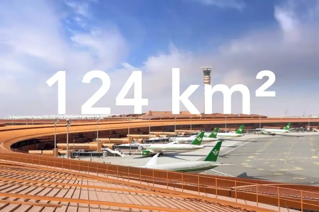
Every decision in a sewer upgrade or drainage expansion depends on the fidelity of the ground surface you hand to designers. In a dense urban corridor next to an international airport, conventional total station and GNSS traverses face line-of-sight gaps and obstruction bias that create uneven accuracy and patchy coverage. That risk is real in North Jeddah, where the area of interest lies adjacent to the airport and spans built-up neighborhoods. Here is what surface truth looks like at the city scale. We captured a continuous 124 square kilometer topographic dataset in North Jeddah and delivered it as a CAD-ready package in under three months from kickoff. Field acquisition took one month. Processing took two months. This timeline gives engineers a single authoritative surface rather than stitched pockets of data collected over a long period. Surface truth is more than a pretty map. It is a defensible stack of products that design teams can trace. The deliverables included an orthomosaic for planimetrics, a Digital Surface Model and Digital Terrain Model for elevation control, contours, 2D CAD drawings, the full list of ground control and independent checkpoints, a documented accuracy assessment, and a formal survey report. These artifacts allow design leads to audit decisions and sign off with confidence. Accuracy management begins at acquisition. We flew an RTK-enabled drone platform with a full-frame photogrammetry camera and built a high-grade control network. A Trimble R12 receiver established and measured ground control points for adjustment and independent checkpoints for validation. This control strategy reduces reliance on interpolation and tightens both horizontal and vertical residuals across built-up corridors. The counterfactual underscores the stakes. A traditional approach across this environment would require multiple field teams for about three months and still lean on interpolation between sparse points. The drone-based program concluded the full scope in less than three months while improving accuracy and completeness for downstream CAD and hydraulics. This difference shortens design cycles and cuts rework for utility corridors and drainage upgrades. Dense Neighborhoods and Airport Constraints The area of interest covers 124 square kilometers in North Jeddah and sits adjacent to the airport, which makes both data capture and flight planning uniquely complex. Large coverage with airport proximity raises operational constraints, while dense neighborhoods create measurement blind spots for traditional crews. Airport-adjacent realities. In an airport environment, teams must plan flight lines to respect controlled airspace and safety buffers. You manage takeoff and landing zones carefully, maintain strict altitude profiles, and schedule sorties to minimize conflicts with traffic patterns. Geofencing unlocks, NOTAM checks, and close coordination with authorities are standard steps for this kind of work. The goal is predictable, repeatable acquisition without drift in GNSS solutions or interruptions to coverage. Built-up urban fabric. High building density, narrow corridors, and road canyons reduce line of sight for total stations and can introduce GNSS multipath for traditional rovers. That combination produces coverage gaps and uneven accuracy when you rely on sparse spot levels collected over long traverses. The case conditions explicitly note that built-up areas make conventional topographic surveys “very challenging” and time-consuming. Why an aerial approach fits this terrain. A drone survey and mapping workflow captures consistent overlap above obstacles and decouples the line of sight from ground constraints. With a DJI M350 RTK and Zenmuse P1 full-frame sensor, you can execute systematic blocks that maintain geometry across long corridors while tying everything to a robust control network. This approach improves continuity through tight streets and variable roof heights. Time pressure from scale. Because the 124 km² footprint is large and the timeframe is short, a ground-only campaign would require many teams for an extended period, yet still lean on interpolation between sparse points. The case estimates that a traditional approach could take about three months with multiple crews in this exact built-up context. Drone acquisition compresses the field schedule while maintaining fidelity for downstream design. What this environment demands from the dataset. To serve urban sewer design, the surface must be continuous across roads, intersections, and residential blocks near the airport. That means full orthomosaic coverage for planimetrics and elevation products that remain stable across building shadows and narrow corridors. These conditions are exactly why the project leveraged drone photogrammetry for the topographic survey requirement in this location. The Method: RTK Photogrammetry Built for Accuracy and Scale Objective and scope. The brief required a drone-based photogrammetry program to produce a topographic map for a groundwater sewer network design. We planned for city-scale coverage and design-ready outputs that engineers could trust. Control first. We began with a high-grade GNSS control strategy. A Trimble R12 established the Primary Reference Marker and measured both Ground Control Points for adjustment and Independent Checkpoints for validation. This gives us traceable horizontal and vertical control across built-up corridors where the line of sight is limited. Airframe and sensor. We executed an acquisition with a DJI M350 RTK paired to a Zenmuse P1 full-frame camera. RTK fixes stabilized camera center positions during flight, which improved the initial network geometry and reduced corrections downstream. Block design and sortie planning. We divided the 124 square kilometer area into flight blocks that respected airport proximity and dense neighborhoods. We set systematic flight lines to keep overlap consistent through narrow streets and variable roof heights, and we staged takeoff and landing zones to maintain safe operations. Acquisition window. Field capture finished in one month. This compressed window ensured consistent lighting and seasonal conditions across the entire mosaic, which reduces seams and radiometric variation. Photogrammetric processing. We ran a rigorous pipeline to turn imagery and control into design-ready surfaces: Import imagery and GNSS metadata, then perform initial alignment with RTK positions. Constrain the bundle adjustment with GCPs, while holding ICPs blind for an independent accuracy check. Generate dense point clouds, then derive the Digital Surface Model and bare earth Digital Terrain Model. Create the orthomosaic for planimetrics, followed by contours suitable for design at the requested scale. Export CAD-ready drawings and the coordinate lists for all control and checkpoints. Validation and QA. We
How Drones Cut Oil & Gas Inspection Time from 2 Weeks to 4 Hours

Capturing the Inspection Challenge Oil and gas remain central to Saudi Arabia’s economy and are critical to achieving the ambitions of Vision 2030. But maintaining the sector’s massive infrastructure from refineries and pipelines to storage tanks has always been a time-consuming, expensive, and risky process. Traditional inspections often rely on scaffolding, cranes, and shutdowns that disrupt operations for weeks at a time. Take the example of a diesel tank inspection. Traditionally, building and dismantling scaffolding, shutting down operations, and deploying manual crews could stretch the process to two weeks or more. During this period, the asset would be offline, resulting in millions of dollars in lost revenue. Now, drones are rewriting this story. The same inspection that once consumed two weeks was completed in just four hours using drones. That is a time savings of 13 days and 20 hours, transforming downtime into uptime and showing exactly why drones are a strategic pillar of Vision 2030. How Drones Transform Energy Operations The adoption of drones in oil and gas is not just about saving time; it is about transforming how the industry works. Faster Workflows: Drones bypass the need for scaffolding and manual climbs. With automated flight paths, they scan entire assets in hours, collecting high-resolution imagery and thermal data that can be analyzed immediately. High Accuracy: Drones equipped with zoom cameras, thermal sensors, and LiDAR detect cracks, corrosion, and leaks invisible to the naked eye. They capture centimeter-level detail, ensuring no defect goes unnoticed. Cost Efficiency: In energy and utilities, drone inspections can cut operational costs by 50–70%. They enable more frequent checks without shutdowns and reduce the manpower and equipment costs of traditional inspections. Safety Gains: Workers no longer need to scale flare stacks, powerlines, or refinery structures. By replacing risky climbs with aerial inspections, companies reduce workplace accidents in hazardous environments by as much as 91%. These technical advantages show why drones are not optional add-ons but enablers of efficiency, safety, and sustainability. Why This Matters for Vision 2030 Economic Efficiency: Faster inspections mean less downtime and higher productivity. Saving nearly 14 days of downtime in one inspection is not just impressive. It is transformative for an industry where every hour of output counts. Sustainability: Drones detect methane leaks faster and more frequently, reducing emissions by 30% or more. This supports the Kingdom’s environmental commitments under Vision 2030 and global climate frameworks. Safety and Social Impact: Reducing accident risk by 91% ensures that workers are safer, healthier, and more productive. This aligns with Vision 2030’s focus on enhancing quality of life. Cross-Sector Relevance: The same drone technology driving oil and gas efficiency also supports smart cities, utilities, agriculture, and environmental monitoring. By investing in drones, Saudi Arabia builds cross-industry capabilities that amplify the impact of Vision 2030. Drones are not just inspection tools; they are strategic assets that deliver measurable results across the national agenda. Roadmap for Scaling Drones in Vision 2030 To fully realize these benefits, Saudi Arabia must accelerate the adoption of drones across industries under Vision 2030. Regulatory Acceleration: Expand frameworks for safe beyond-visual-line-of-sight (BVLOS) operations, enabling drones to handle pipeline monitoring, logistics, and regional inspections without human oversight. Local R&D and Manufacturing: Invest in Saudi-based drone hardware, sensors, and data analytics platforms. This ensures the Kingdom builds sovereign capabilities and reduces reliance on imports. Ecosystem Platforms: Strengthen collaboration through platforms like SADEX, where regulators, operators, and innovators align standards, showcase real-world applications, and create joint ventures. Scaling Across Sectors: Move from pilots to national deployment by embedding drones into routine operations for oil and gas, utilities, smart cities, and agriculture. By following this roadmap, Saudi Arabia can position drones as a national infrastructure layer, not just a sector-specific tool.
8x Faster Your Minerals Exploration With Drone and Satellite Applications
The Evolving Challenges of Mineral Exploration The race for critical minerals has intensified. Copper, lithium, cobalt, and rare earths are in unprecedented demand to power renewable energy, electric vehicles, and digital technologies. By 2040, lithium demand could reach 1,326 kt, copper 36,379 kt, and rare earths 169 kt. But traditional mineral exploration methods struggle to keep pace. Ground crews require weeks to map terrain, and costs continue to climb with lithium exploration investment surpassing $1 billion in 2024 alone. Field operations are slow, labor-intensive, and often environmentally disruptive. Remote Sensing Technologies in Exploration Mineral exploration is increasingly data-driven, and remote sensing has become the backbone of early-stage decision-making. By combining satellite-based and drone-based technologies, geologists can access unprecedented levels of spatial, spectral, and temporal data, which traditional surveys cannot achieve at scale. Satellite-Based Applications Multispectral & Hyperspectral Imaging Multispectral sensors capture data across a limited number of discrete bands (often 5–10), while hyperspectral sensors collect data across hundreds of contiguous spectral bands. This capability allows geologists to detect subtle differences in mineral composition by analyzing reflectance spectra. For instance: Hydrothermal alteration zones, key indicators of copper or gold deposits, display unique absorption features in the shortwave infrared (SWIR) range. Iron oxides, clays, and carbonates each have distinct spectral signatures, making it possible to map surface mineral assemblages with high precision. Hyperspectral data, when fused with geological maps, allows for rapid anomaly detection across large regions, helping exploration teams focus ground efforts only where it matters. Synthetic Aperture Radar (SAR & InSAR) SAR uses microwave signals to penetrate clouds, smoke, or even vegetation, making it invaluable in regions with frequent dust storms or tropical climates. It excels in detecting structural geology features: Lineaments and fault systems, often associated with mineralization pathways. Lithological boundaries, aiding in regional geological mapping. InSAR (Interferometric SAR) can monitor ground deformation at millimeter accuracy, which is essential not only for exploration but also for environmental baseline studies and mine site stability assessments. Digital Elevation Models (DEMs) High-resolution DEMs provide the third dimension of exploration data: elevation. These models are derived from stereo imagery, radar, or LiDAR and offer critical terrain intelligence: Drainage patterns that may indicate secondary mineral deposits. Structural controls such as folds, domes, or intrusions, often associated with ore bodies. Watershed and slope analysis for logistical planning of access roads, drilling pads, and camp infrastructure. DEM-derived slope and aspect models also assist in understanding erosion processes and landscape evolution, factors often correlated with mineral deposition. This reality makes one thing clear: the industry needs rapid, accurate, and scalable geospatial intelligence in pre-mining stages. Remote sensing, powered by a combination of satellite and drone-based imagery, is redefining how exploration companies detect mineral prospects before drilling begins. Drone-Based Applications While satellites provide regional context, drones deliver the site-specific precision that exploration companies need to make confident drilling and investment decisions. By flying closer to the surface and carrying specialized payloads, drones capture centimeter-level data that traditional ground teams or satellites cannot match in resolution. High-Resolution Photogrammetry Drone-mounted RGB cameras use overlapping imagery to create orthophotos, digital surface models (DSMs), and digital terrain models (DTMs). With ground control points (GCPs) or real-time kinematic (RTK) positioning, these models achieve 1–5 cm accuracy. This level of detail enables mapping of outcrops, faults, and fractures invisible in satellite imagery. Photogrammetry also produces accurate volumetric measurements, useful for quantifying overburden or monitoring stockpiles during later mining phases. Its visual clarity makes it ideal for geological mapping, allowing teams to distinguish rock types and alteration zones quickly. UAV-LiDAR LiDAR-equipped drones emit thousands of laser pulses per second, penetrating vegetation and recording ground elevation with 2–3 cm vertical accuracy. In forested or bush-covered terrains, UAV-LiDAR produces bare-earth models that expose structural geology otherwise hidden from view. LiDAR intensity data also helps differentiate rock and soil types based on reflectance properties, adding another layer of geological interpretation. With high point densities (up to 300 points/m²), LiDAR is invaluable for fault detection, fracture mapping, and slope stability analysis. Geophysical Payloads Beyond optical and laser scanning, drones now carry advanced geophysical sensors once restricted to manned aircraft: Aeromagnetic Surveys: Detect magnetic anomalies linked to mineralized intrusions. UAV-borne magnetometers can fly at low altitudes (<50 m AGL), producing higher-resolution datasets than fixed-wing aircraft. Electromagnetic (EM) Surveys: UAV-EM systems measure conductivity contrasts to locate ore bodies rich in sulfides or clays. These surveys highlight targets buried beneath cover sequences. Ground Penetrating Radar (GPR): Shallow subsurface imaging up to several meters deep, useful for detecting weathered ore caps or buried structures. Multispectral & Thermal Sensors: Identify surface alteration halos, monitor moisture variations, and highlight thermal anomalies that may point to mineralization zones. Productivity and Efficiency Gains Drones excel not only in resolution but also in operational productivity: Traditional ground-based topographic surveys average 8 km per day per team. Drone surveys can map up to 60 km per day per team, delivering an 8x improvement. Geophysical surveys benefit similarly, with UAV-mounted systems covering more ground in less time and at lower cost than manned aircraft or ground crews. Faster data collection means earlier availability of actionable datasets, enabling exploration managers to move from prospecting to drilling much more rapidly. Geophysical Payloads One of the most significant advancements in drone-based exploration lies in their ability to carry specialized geophysical instruments, enabling surveys that previously required expensive manned aircraft or labor-intensive ground crews. These payloads allow exploration companies to detect anomalies hidden beneath the surface, drastically improving subsurface intelligence in early-stage mineral exploration. Aeromagnetic Surveys Drones equipped with fluxgate or optically pumped magnetometers measure variations in the Earth’s magnetic field caused by subsurface rocks. Technical Edge: UAVs can fly low and slow (30–50 m AGL, ~8–15 m/s), enabling high-resolution magnetic data capture compared to manned aircraft, which typically operate at higher altitudes (~100–200 m AGL). Resolution: UAV magnetic surveys can detect subtle anomalies as small as tens of nanotesla (nT), crucial for identifying mineralized intrusions, dykes, or skarn deposits. Applications: Ideal for mapping ferromagnetic minerals like magnetite, or indirect indicators of copper
Cut Survey Labor Costs by Up to 60% with High-Accuracy Drone Surveys
Precision from the Ground Up A High-Accuracy Drone Survey is the foundation for efficient solar and wind energy projects. In renewable development, the land beneath your infrastructure determines how much energy you generate and how much profit you keep. For solar farms, even small slope errors can reduce sunlight capture. A misalignment of just a few degrees can lead to significant annual energy losses. For wind projects, poorly positioned turbines can experience reduced wind flow and increased turbulence, which lowers their capacity factor and increases wear on components. Saudi Arabia’s Vision 2030 sets ambitious renewable energy targets, with a commitment of $270 billion to solar, wind, and green hydrogen. Mega-projects like NEOM’s 2.6 GW solar plant, designed to power over one million homes, and Dumat Al-Jandal’s 400 MW wind farm, producing electricity for 70,000 households, depend on accurate terrain data to meet strict timelines and performance goals. Why Traditional Surveys Struggle to Keep Pace Traditional ground surveys rely on GPS rovers, total stations, or theodolites, which only collect discrete data points. These require interpolation to form a terrain model, often missing small but important surface variations. A single surveyor can cover only 8–10 km per day in ideal conditions. Large-scale renewable sites often span hundreds of hectares. In such cases, ground-based surveying can take 2–3 weeks, creating bottlenecks in permitting and design. Terrain challenges like steep slopes, soft sand, and rocky outcrops slow crews further, and weather conditions in desert or coastal regions can lead to additional delays. Processing traditional survey data can also take several more days, meaning that valuable time passes before engineers receive usable deliverables. When multiplied across the number of sites under development, these delays can push back renewable energy capacity delivery dates and threaten project profitability. The Technical Advantage of High-Accuracy Drone Surveys A High-Accuracy Drone Survey combines speed, precision, and data richness, creating a digital foundation for renewable project design. Speed and Coverage Platforms like the DJI Matrice 400 can cover 2.5 km² in a single 59-minute flight, mapping over 7.5 km² per day with LiDAR or photogrammetry payloads. This makes them 5–10 times faster than traditional surveys, accelerating design and permitting workflows. Accuracy for Engineering Decisions LiDAR mapping: 2–3 cm vertical accuracy, effective in complex or vegetated terrain. Photogrammetry mapping: 1–5 cm accuracy with high visual clarity. Both are enhanced by RTK GPS to achieve centimeter-level precision. Data Richness for Renewable Applications Drone surveys capture millions of data points, creating dense digital terrain models (DTM) and digital surface models (DSM). This supports: Shading analysis for solar farms to optimize panel tilt and spacing. Slope mapping for wind turbines to ensure stable foundations and optimal wind exposure. Drainage and erosion planning for site stability. Seamless Integration Data integrates directly into CAD, GIS, and BIM workflows, enabling engineers to work with up-to-date, site-specific information and make faster design adjustments. Insert Technical Performance Data Here: Daily coverage capacity, LiDAR vs. photogrammetry accuracy, and processing turnaround time. Measurable Economic Impact Switching to a High-Accuracy Drone Survey is not just a technical upgrade — it is a cost-saving strategy. Lower Labor Costs Drone mapping reduces the need for large field crews. A drone team typically consists of 2–3 operators, compared to 6–10 for a ground survey team. This reduction can cut labor costs by 35–60%, including travel and accommodation savings. Faster Permitting With orthophotos, DTM, and DSM available within 24–48 hours, engineering teams can submit complete site documentation earlier, often shaving weeks off regulatory approval timelines. Earlier Commissioning Shorter survey and permitting timelines bring earlier project start dates. In large-scale renewable projects, even a week’s head start can generate substantial additional revenue from earlier energy sales. Reduced Rework Accurate site data minimizes costly design changes mid-construction and reduces material waste. Insert Economic Impact Data Here: Average permitting time saved, projected value of earlier commissioning for a 200 MW solar farm, and potential cost savings from avoided rework. From Survey to Energy Output With high-accuracy mapping, engineering teams can design with confidence, maximize energy yield, and meet delivery deadlines. For developers, EPC firms, and utility companies, integrating drone surveys early in the project lifecycle ensures faster, smarter, and more profitable renewable energy projects. Talk to us now to schedule you FREE experience firsthand to see how drone surveys can accelerate your next project as every day counts.
How Drones Cut 8 hours to 30 Minutes in Topographic Survey

Drone Topographic Mapping is rapidly redefining how utility providers and EPC firms approach transmission line surveys. In a region where megaproject timelines are non-negotiable, particularly in Saudi Arabia and across the MENA region, traditional methods simply can’t keep pace with modern demands. 1. Why Timelines Matter in Power Transmission Projects In Saudi Arabia’s ambitious energy roadmap under Vision 2030, utility-scale transmission line projects often span hundreds of kilometers, connecting remote regions to rapidly growing industrial and residential hubs. Every delay in surveying can push back construction, permitting, and ultimately, power delivery. Transmission corridor surveys are a foundational stage. The faster and more accurately they’re executed, the sooner engineering, procurement, and construction (EPC) activities can move forward. That’s why drone survey technologies are becoming essential tools for government-backed utilities and private sector providers alike. 2. Topographic Survey Challenges with Traditional Methods Conventional ground surveys and manned aerial LiDAR come with inherent limitations: Time-consuming fieldwork across rough terrains like deserts, wadis, and escarpments Permitting delays for helicopter LiDAR flights in restricted airspaces Data gaps due to vegetation, uneven elevation, or inaccessible locations Safety concerns for survey crews working in remote or hazardous zones These challenges not only prolong pre-construction stages but also increase project risk and cost. 3. Drone Technology That Speeds Up Data Collection In practical terms, a single surveyor using traditional GPS methods can only cover about 8 kilometers of transmission line per day during an 8-hour shift. In contrast, drone topographic mapping can cover the same distance in just one 30-minute flight, dramatically accelerating survey timelines while freeing up manpower for other mission-critical tasks. Topographic drone mapping offers a faster, safer, and more scalable alternative: LiDAR-equipped UAVs capture high-resolution 3D terrain data even through vegetation RTK/PPK GNSS systems ensure centimeter-level accuracy Automated flight paths ensure consistent coverage of the entire corridor Daily area coverage can exceed 10–20 km², even in challenging environments Drone-collected data is also processed into DSM, DTM, orthophotos, and contour lines within 24–48 hours, supporting faster decision-making for powerline routing. 4. Workflow Benefits: Faster Route Planning and Permitting Drone Topographic Mapping doesn’t just collect data faster, it transforms the entire project workflow: Pre-engineering teams can identify optimal tower placements early Environmental teams can assess vegetation impact and right-of-way risks Regulatory approvals move faster with clear visual evidence and elevation profiles BIM teams get access to high-quality base maps for digital twin integration Together, these speed up powerline inspection, route validation, and approval stages. 5. Best Practices for Drone Corridor Mapping in Power Projects To get the best out of drone topographic solutions, power utilities and drone service providers must: Align flight plans with corridor width and terrain complexity Utilize dual-sensor payloads (e.g., LiDAR + RGB) for complementary datasets Schedule surveys during optimal weather conditions for maximum clarity Comply with aviation authority regulations for BVLOS or restricted zones Incorporate GCPs (Ground Control Points) to enhance vertical accuracy When combined with robust data post-processing, these practices deliver survey-grade results that rival or exceed conventional methods. Conclusion Drone Topographic Mapping isn’t just a buzzword. It’s a strategic enabler for faster, smarter power infrastructure development. As powerline projects scale across Saudi Arabia and the MENA region, adopting drone-enabled corridor mapping gives utilities a critical edge in speed, accuracy, and cost-efficiency. The future of energy transmission depends not just on what gets built, but how quickly and intelligently it begins.
Why 16.5% Market Growth in MEA Demands Smarter Drone Ground Support Now

The commercial drone market in the Middle East & Africa (MEA) is entering a phase of rapid expansion valued at $1.60 billion in 2023 and projected to nearly triple to $4.65 billion by 2030, growing at a CAGR of 16.5% from 2024 onward. This surge reflects increasing reliance on drone technology across industries such as infrastructure, energy, logistics, agriculture, and public safety. But while aerial platforms often take center stage, what happens on the ground is just as vital. Drone ground support is no longer a background function. It is the critical backbone that enables safe, scalable, and high-performing drone missions. From mission planning and live monitoring to post-flight data processing and maintenance, robust ground support ensures drone operations remain compliant, continuous, and consistently valuable. At Terra Drone Arabia, we’ve built an integrated ecosystem of flight platforms, power systems, software tools, and skilled technical crews to support every stage of the drone lifecycle. This editorial dives into the essential pillars of drone ground support, highlighting how our infrastructure transforms complex drone deployments into streamlined, reliable solutions across the region’s most demanding sectors. Intelligent Flight Planning and Management: Terra FOS in Action Successful drone operations begin well before takeoff with intelligent planning and mission orchestration. Drone ground support relies heavily on advanced flight management systems that do more than just draw flight paths. At Terra Drone Arabia, this capability is powered by Terra FOS (Flight Operating System) a centralized, cloud-connected platform built to schedule, manage, and monitor drone operations at scale. Unlike ad hoc flight planning or manual input in consumer-grade apps, Terra FOS enables enterprise-grade coordination across multiple drone fleets, missions, operators, and geofenced regions. The platform automatically considers terrain elevation, restricted airspace, active NOTAMs, weather data, and mission-specific flight envelopes to generate optimal flight paths. This reduces the risk of collisions, route redundancy, and airspace violations. For repeatable inspection missions like flare stack scans, transmission line patrols, or perimeter surveys Terra FOS allows operators to predefine flight parameters (altitude, speed, overlap ratios, sensor trigger rates) and save them as reusable mission templates. This results in consistent, high-quality data capture across recurring operations, even when flown by different teams on different days. Terra FOS also integrates tightly with GACA-authorized airspace systems, helping operators secure automated approvals for compliant flights. It logs every mission’s metadata, telemetry, and pilot actions, creating a verifiable audit trail for quality control and incident analysis. From an operational perspective, the system supports: Multi-mission queuing: Schedule several inspections across different sites from a single dashboard. Automated pre-flight checklists: Ensure regulatory and equipment readiness before arming motors. Real-time status syncing: Track drone and pilot status via a connected GCS, improving field-team coordination. Live fail-safe configuration: Set mission triggers like Return-to-Home (RTH) for battery levels, communication loss, or weather anomalies. This level of precision not only reduces mission preparation time by up to 40%, but also improves safety outcomes by minimizing manual error. In large-scale deployments like asset inspection across NEOM or environmental monitoring near refinery zones, Terra FOS provides operational transparency and predictability, giving stakeholders full visibility into each mission’s purpose, scope, and timeline. In essence, intelligent flight planning via Terra FOS is not just about navigation. It’s a strategic command system that transforms how drones are deployed, tracked, and managed in the field. Tethered Power Supply: When Continuous Operations Count In many critical drone missions, especially those requiring extended hover time or persistent surveillance, traditional battery-powered systems face a fundamental limitation: finite flight time. This is where tethered power supply systems come into play as a vital component of drone ground support, enabling continuous, high-endurance operations with enhanced safety and efficiency. At Terra Drone Arabia, we deploy the Terra Xross 1 system integrated with a tethered power module for scenarios where uninterrupted aerial presence is non-negotiable. This configuration eliminates the downtime associated with battery swaps and mid-mission landings, making it ideal for indoor inspections, GPS-denied zones, event surveillance, and fixed-position operations in high-risk areas. How It Works A tethered drone system replaces the onboard battery with a ground-based power source, supplying constant energy through a reinforced micro-cable. This cable not only delivers power but also provides a redundant communication link and a mechanical restraint to keep the drone stable in unpredictable environments. Unlike free-flying drones that are limited by 25–40 minutes of flight time, tethered drones can remain airborne for 6–12 hours or more, depending on the application. Operational Benefits Persistent Observation: Whether monitoring flare stacks, congested event zones, or border security perimeters, the drone can hover indefinitely without power interruption. Enhanced Safety: The tether acts as a physical safeguard, ensuring the drone remains within a defined operating radius, reducing flyaway risks and ensuring compliance with no-fly boundaries. Reduced Crew Load: With fewer takeoffs, landings, and battery changes, operators can focus on mission-critical analytics instead of flight management logistics. Data Continuity: Eliminates the data fragmentation caused by pausing operations to recharge, allowing for seamless time-lapse recording, anomaly tracking, or multi-hour 3D scanning. Use Case Scenarios Facility Surveillance: 24/7 observation of oil & gas plants, utility substations, or storage yards where drone downtime could translate into blind spots or elevated risk. Indoor Inspection: Warehouses, tunnels, or containment buildings where GPS signals are weak or non-existent. Emergency Response Command Posts: Keeping a bird’s-eye view over unfolding incidents, such as firebreaks, protests, or medical triage zones. In such operations, battery endurance isn’t just a technical limitation. It becomes a mission risk. Tethered systems like Terra Xross 1 redefine what’s possible in drone deployment by removing the single biggest operational bottleneck: limited airtime. Incorporating a tethered power solution into your drone fleet strategy is a strategic move not just for extending mission duration, but for ensuring precision, stability, and uninterrupted situational awareness in environments where reliability is non-negotiable. Ground Control Stations: Real-Time Control with Maximum Clarity On the field, Ground Control Stations (GCS) serve as the operational cockpit for every drone mission. Whether it’s a rugged laptop running DJI Pilot 2, or mobile consoles paired with Terra Mapper, GCS platforms
Retail Drone Delivery: Solving Last-Mile Logistics

Retail drone delivery operations are transforming the last mile of the supply chain—a stage traditionally known for being the most expensive and inefficient. As e-commerce continues to expand, retailers face growing pressure to deliver goods faster while keeping costs low. Conventional delivery methods struggle to meet this demand due to road congestion, fuel costs, and human labor limitations. Autonomous drones are changing that. These unmanned aerial vehicles (UAVs) offer a new logistics model that combines speed, automation, and sustainability. Instead of navigating clogged streets, drones fly direct-to-door routes, completing deliveries in minutes rather than hours. Beyond speed, they provide a technical infrastructure that makes logistics smarter, not just faster. The Last-Mile Delivery Problem in Retail Last-mile delivery accounts for over 50% of total shipping costs in the retail sector. Whether in dense cities or sprawling suburbs, the final leg of delivery is where logistics companies lose both time and profit. Several factors contribute to this problem: Traffic Congestion: Urban deliveries are delayed by gridlock, stoplights, and parking restrictions. Inefficient Routing: Ground vehicles must follow complex delivery sequences, often with multiple stops and returns. Labor Shortages: Courier demand outpaces supply, leading to rising costs and staffing challenges. Failed Deliveries: Missed drop-offs require re-attempts, compounding costs and customer frustration. At the same time, consumer expectations are rising. Customers now expect same-day or even sub-hour delivery, especially for essential items. Retailers face the dual challenge of meeting these expectations while keeping operational expenses under control. The solution lies in rethinking logistics entirely—and that’s where drones come in. Inside Retail Drone Delivery Operations: How It Works Retail drone delivery operations are not just about flying drones—they’re about automating logistics at every stage, from order placement to doorstep delivery. Here’s how the system works: In order to Launch When a customer places an order eligible for drone delivery, the retailer’s system automatically prepares the package for UAV dispatch. Items are scanned, weighed, and packaged in lightweight containers designed for drone payload bays. The UAV then receives flight instructions via cloud-based fleet management software that integrates with the retailer’s e-commerce platform. Autonomous Flight Paths Once airborne, the drone navigates using GPS, RTK positioning, and onboard AI systems. It calculates the most efficient flight path, accounting for: Airspace regulations No-fly zones Weather conditions Obstacle avoidance (trees, buildings, other drones) Advanced UTM (Unmanned Traffic Management) systems coordinate drone traffic in real time, ensuring safe, collision-free operations. Package Handling and Delivery Most retail drones use a tethered delivery system. The UAV hovers above the delivery point, typically a customer’s backyard or porch, and lowers the package gently to the ground. This method protects fragile items and ensures safety without the drone needing to land. Once the package is delivered, the drone ascends and returns to base automatically. Fleet Management and Maintenance Drones are managed as part of a connected fleet. Software monitors: Battery health Flight logs Maintenance cycles Airspace permissions When not in use, drones recharge at automated docking stations or swap batteries through robotic systems, minimizing downtime and maximizing delivery throughput. Real-World Example: Walmart & Wing’s 19-Minute Drone Delivery Model A recent partnership between Walmart and Wing demonstrates how retail drone delivery works at scale. In 2023, Walmart launched the world’s largest drone delivery expansion in collaboration with Wing. Key highlights of this operation include: Delivery Times Cut from 60 Minutes to Under 19 Minutes: Traditional same-day delivery often takes an hour or more, but Walmart’s UAV service completes flights in under 20 minutes. Over 60,000 Eligible Items: Customers can order groceries, household goods, and over-the-counter medications by drone. Suburban Focus: The program targets residential areas where road traffic and delivery inefficiencies are most pronounced. This initiative has proven that drone delivery is not just a concept—it’s a scalable, profitable logistics solution that’s already improving customer satisfaction and lowering costs. Learn more: Wing & Walmart Drone Delivery Expansion Why Retail Drone Delivery Is the Future Drone delivery operations offer retailers a combination of cost savings, environmental benefits, and customer service improvements: Speed: Drones deliver within minutes, outperforming road-based couriers by flying direct aerial routes. Efficiency: UAVs reduce vehicle fuel costs, labor expenses, and maintenance associated with ground delivery fleets. Sustainability: Electric drones emit zero direct emissions, helping retailers meet carbon reduction goals. Automation: Advanced AI and real-time airspace management enable autonomous operations with minimal human oversight. Scalability: Drone fleets are easy to expand—adding new UAVs is faster and cheaper than scaling traditional delivery vehicles. As drone regulations evolve and airspace management systems mature, retailers will increasingly integrate UAV logistics into their fulfillment strategies. What was once a pilot program is now a mainstream operational model. Conclusion Retail drone delivery operations are solving the last-mile logistics crisis by making deliveries faster, smarter, and greener. The combination of autonomous UAV technology, real-world logistics integration, and customer-centric service models creates a system that benefits both retailers and consumers. The success of the Walmart & Wing partnership highlights the real potential of drone delivery at scale. By cutting delivery times to under 19 minutes, retailers are setting new benchmarks for efficiency and customer satisfaction. For retailers considering the next step in logistics innovation, drone delivery isn’t the future. It’s the present.
Drone Applications for Environmental: From Desertification to Disaster Response

Drone applications for environmental management are rapidly redefining how industries, governments, and conservation groups address pressing ecological challenges. As Saudi Arabia and the broader MENA region face accelerating climate risks from desertification to greenhouse gas emissions, there’s a critical need for scalable, technology-driven solutions. Drones now serve as force multipliers in this mission, combining aerial reach, sensor diversity, and data precision to revolutionize sustainability practices. In this article, you’ll discover how drone support reforestation efforts by planting millions of trees, monitors air and water quality, tracks wildlife populations, and enhances disaster response. These applications aren’t futuristic concepts; they’re in use today, delivering measurable impact in Saudi Arabia and beyond. The Power of Drone Applications for Environmental Monitoring Drone platforms equipped with advanced sensors deliver environmental data at a scale and speed unmatched by traditional ground crews. Drone flight pre-programmed grid patterns, capturing high-resolution imagery, multispectral maps, and thermal overlays in real time. Multispectral sensors assess plant health and land degradation by calculating vegetation indices like NDVI. Thermal cameras detect subtle temperature differences that reveal heat stress in crops or locate gas leaks invisible to the naked eye. LiDAR-equipped drones build detailed 3D models of terrain and vegetation structure, enabling planners to measure canopy density, erosion rates, and water flow paths. Gas-sensing drones carry laser-based spectrometers, detecting greenhouse gas leaks such as methane at part-per-billion levels. By combining all of these capabilities, drones minimize human risk, reduce costs, and deliver faster environmental insights for smarter decisions. Real-World Drone Applications for Environmental Solutions Combating Desertification and Reforestation In Saudi Arabia, large-scale land restoration is no longer a vision—it’s a reality powered by drones. Drone applications for environmental reforestation begin with mapping. Multispectral cameras scan vast tracts of arid land, identifying zones with the highest potential for restoration. Using this data, drones disperse biodegradable seed pods that contain a mixture of native plant seeds, nutrients, and moisture-retaining materials. Each pod is placed precisely where conditions favor growth, reducing waste and increasing germination success. For example, Saudi Aramco launched a landmark project to plant one million trees by 2025, using drones for seed dispersal and reforestation management. Reference the case study here. Quarterly drone flights equipped with LiDAR and RGB sensors monitor the progress of the new green zones, ensuring data-backed land management. Air Quality and Greenhouse Gas (GHG) Monitoring Monitoring air quality is critical for both environmental and human health. Drone-based gas sensing enables oil & gas facilities to detect fugitive emissions, including methane, VOCs, and NO₂. A drone equipped with TDLAS (Tunable Diode Laser Absorption Spectroscopy) fly along pipelines and around industrial plants, scanning for leaks with precision down to 0.1 ppm. At the same time, mobile air-quality sensors mounted on drones measure PM2.5, SO₂, and CO₂ concentrations across operational sites and adjacent communities. This data supports ESG reporting and accelerates corporate compliance with net-zero emissions goals. To further explore how drones contribute to decarbonization strategies. Water Resource Management In arid regions like Saudi Arabia, efficient water management is vital. Drones equipped with LiDAR scan reservoirs and dams, generating bathymetric data to track sediment buildup and assess storage capacity. A drone can also perform aerial water sampling by deploying floating platforms that collect pH, turbidity, and pollutant measurements from lakes, rivers, or industrial runoff zones. During flood seasons, drones play a key role in rapid response. By flying over affected areas, they capture orthomosaics that detail flood extents, road blockages, and safe routes for emergency services. This data informs real-time decision-making for disaster mitigation. Wildlife Protection and Biodiversity Monitoring Environmental drone applications extend to safeguarding wildlife and tracking biodiversity. Thermal drones perform nighttime patrols over conservation zones, detecting illegal poaching activities by identifying human and animal heat signatures. For population tracking, drone capture aerial imagery of herds or flocks, feeding it into AI-powered models that count and classify species with over 95% accuracy. Multispectral flights also map critical habitats, identifying vegetation types and ecosystem health indicators. This information guides land-use planning, ensuring that conservation zones are properly protected while industrial development proceeds responsibly. Disaster Management and Emergency Response When disasters strike, speed is everything. Drones provide Immediate post-event assessments without risking human life. Drone capture high-resolution imagery of affected areas, revealing damaged infrastructure, flooded regions, or landslide zones. Using real-time data, rescue teams identify trapped individuals with thermal imaging and chart the safest paths for intervention. Environmental impacts such as oil spills or chemical leaks are also tracked via drone sensors. Drone-based monitoring quantifies pollutant spread, allowing teams to allocate remediation resources efficiently. For additional reading on the role of drones in disaster response, see Innotech Today’s analysis. The Technology Behind Environmental Drone Solutions The technological backbone of these applications lies in a combination of high-end sensors, advanced data processing, and platform versatility. Multispectral and hyperspectral cameras detect subtle changes in plant health and land degradation. Thermal radiometers measure surface temperature differentials, vital for detecting gas leaks or monitoring irrigation efficiency. LiDAR scanners generate dense point clouds that model topography and vegetation structure in 3D. On the software side, cloud-native platforms such as Terra Mapper and Terra 3D Inspect process and analyze the data, transforming raw imagery into actionable insights. AI-driven classification algorithms tag anomalies, while APIs push reports directly into enterprise asset management systems. Fixed-wing drones cover vast areas efficiently, while multi-rotor drones handle precision tasks such as seed deployment or gas leak detection. Challenges and Future Outlook Despite the transformative potential of drone applications for environmental work, challenges remain. Regulatory hurdles limit beyond-visual-line-of-sight (BVLOS) operations, though Unmanned Traffic Management (UTM) systems are helping to streamline airspace approvals. The data volume generated by a multi-sensor drone is massive, requiring robust cloud infrastructure and edge-processing capabilities to handle real-time analysis. High-end sensor costs also pose an entry barrier, but as demand grows, economies of scale are reducing per-unit expenses. Looking forward, the integration of autonomous drone swarms, IoT-triggered missions, and real-time AI analysis will push environmental monitoring into a new era. Swarm technology will enable coordinated, multi-drone missions covering hundreds of
Scaling Your Drone Fleet: Four Pillars for Pilots

Infrastructure managers often start small. One-off flights to inspect a bridge or survey an oil pipeline. Yet, when the time comes to expand, they encounter fragmented procedures, regulatory hurdles, and interoperability gaps. Scaling drone fleet capabilities provides the answer: a repeatable, secure, and high-impact program that spans dozens of assets without sacrificing quality or compliance. Below, we present four foundational pillars that elevate your UAV initiative from a proof-of-concept to an enterprise-grade drone program, driving safety, efficiency, and data-driven decision-making at scale. 1 Standardized Operations & Procedures Success hinges on documented workflows that every pilot, technician, and analyst follows. When you standardize mission planning, flight execution, and data validation, you eliminate variability and ensure repeatable outcomes. Begin by codifying flight planning templates within your Flight Operating System (e.g., Terra FOS). Each template specifies altitude, speed, sensor settings, and waypoint precision (±10 cm). Pilots select the “Pipeline ROW Scan” or “Flare-Stack Survey” profile and deploy instantly—no bespoke planning required. Next, implement payload calibration routines. For thermal cameras, use a field-portable blackbody target; for LiDAR, run a zero-distance baseline check. Automate these checks before every sortie and log the results to your QA dashboard. If calibration drifts beyond tolerance, Terra FOS flags the asset for maintenance. Finally, integrate data-quality audits. Post-flight, automated scripts verify image resolution, GPS accuracy, and sensor metadata. Any missing or corrupt data blocks trigger a scheduled flight. This closed loop assures leadership that every dataset entering your GIS or BIM environment meets enterprise standards. 2 Strategic Partnerships & Vendor Registrations No drone program scales in isolation. You need a network of certified vendors, payload specialists, and service providers to ensure uptime and technological edge. Vendor portal integration is critical. Maintain active status with Aramco (CCC 06-02-081423-N), Saudi Electricity Company, MA’ADEN, NEOM, and Red Sea Global. Automate your registration renewals—insurance certificates, safety audits, and corporate credentials—via a centralized vendor-management module, so you never miss a renewal deadline. Forge payload alliances with sensor OEMs: collaborate with BLV for gas-detection pods and Velodyne for high-density LiDAR. Define service-level agreements guaranteeing 24-hour turnarounds on repairs or software updates. This ecosystem approach ensures your fleet always flies with the latest, most reliable hardware. Training partnerships complete the picture. Work with GACA-approved academies to deliver pilot and sensor-operator certification aligned to ISO 9712 and ISO 45001 standards. Track proficiency in a Learning Management System, mapping skills to mission roles—pilot, payload specialist, or data analyst—so qualified experts staff each mission. 3 Regulatory Compliance & Airspace Management Scaling beyond a handful of flights means navigating a complex airspace and stringent safety regulations. Automated systems are your ally. Integrate UTM/UTMRA APIs within your FOS platform to request flight authorizations in real-time. Terra FOS queries GACA or Unifly servers, secures digital permits, and loads geo-fence boundaries onto the pilot’s controller map—eliminating manual paperwork and runway delays. Embed a Safety Management System (SMS) into every mission. Use flight data recorders to log deviations, near-misses, and operational anomalies. Feed these logs into a root-cause analysis tool and update your SOPs accordingly, closing the loop on continuous improvement. Finally, maintain ISO 9001:2015 and ISO 45001:2018 certifications by conducting regular internal audits. Document non-conformances, implement corrective actions, and track progress in a quality-management portal—ensuring your expanding program remains audit-ready. 4 Vision 2030 Alignment & Sustainability In Saudi Arabia, aligning with Vision 2030 not only demonstrates national commitment but also unlocks long-term support and incentives. Localize your R&D: partner with King Abdullah University of Science & Technology (KAUST) to co-develop dust-resilient sensor filters and AI models trained on regional asset imagery. Formalize these collaborations in joint research agreements, securing IP credits and government grants. Measure your program’s ESG impact. Use drone analytics to quantify reductions in scaffolding usage, engine idling hours, and manned-access risks. Integrate these metrics into quarterly sustainability reports, demonstrating direct contributions to Saudi net-zero and smart-city targets. Showcase success at public forums from NEOM to Red Sea Global sustainability summits, underscoring how scaling drone fleet initiatives drives national infrastructure resilience and digital transformation. Conclusion Scaling drone fleet operations transforms UAVs into mission-critical platforms, not just experimental tools. By standardizing procedures, cultivating strategic partnerships, automating compliance, and aligning with Vision 2030, organizations can achieve continuous oversight, boost efficiency, and enhance safety across every infrastructure asset. 📩 Ready to scale your drone program? Partner with our experts for your enterprise-grade solutions. 👉 Consult Now
Unlocking the Potential for Scaling Drone Programs in Infrastructure

Infrastructure inspection and management face rising demands for speed, safety, and precision. Traditional methods of manually sending inspectors aloft on scaffolds, deploying rope-access teams, or scheduling production shutdowns are expensive, time-consuming, and expose personnel to hazards. The potential for drone programs in infrastructure lies in transforming these workflows with unmanned aerial vehicles (UAVs) that collect multi-sensor data, automate repeatable missions and integrate seamlessly into digital asset ecosystems. The Evolving Landscape of Infrastructure Inspection and Management Over the past decade, infrastructure inspection has shifted from manual, intermittent surveys to a continuous, data-driven discipline. Traditional methods of sending technicians aloft via rope access or erecting scaffolding carry inherent risks, slow turnaround, and high labor costs. Today’s challenge is twofold: how to increase inspection frequency and how to extract richer, more actionable data without disrupting operations, is through drones. Integration of Multi-Modal Sensor Networks Modern inspection platforms combine aerial drones with fixed or mobile ground sensors—such as stationary LiDAR units, fiber-optic strain gauges, and embedded vibration monitors—to form an Internet of Things (IoT) fabric across a bridge, pipeline, or substation. Drones contribute to the aerial perspective, capturing centimeter-level 3D point clouds, gigapixel orthophotos, and thermal radiometry. Meanwhile, ground-based sensors offer real-time readings of structural strain, temperature, and vibration. By fusing these datasets in a central analytics engine, operators can correlate surface anomalies detected by UAV thermal scans with underlying stress data, allowing early detection of fatigue cracking or foundation settling. Digital Twin and BIM Convergence Infrastructure owners increasingly adopt Building Information Modeling (BIM) and digital twins to manage asset lifecycles. Drones play a pivotal role in populating these virtual models: high-density LiDAR flights produce exact geometry; photogrammetric images are textured onto the 3D mesh to reflect actual surface conditions; and thermal and multispectral layers are overlaid for health-score mapping. Advanced platforms then employ change-detection algorithms—comparing successive drone scans to the BIM baseline—to automatically flag deviations beyond defined tolerances. These digital twins serve not only for inspection but also for simulation of load-bearing scenarios, erosion studies, and predictive maintenance modeling. Cloud-Native Collaboration & Compliance Finally, the management layer has transformed with cloud-native inspection portals, where stakeholders from different disciplines (engineering, HSE, asset management) access synchronized dashboards. Data provenance, audit trails, and regulatory reporting can be generated at the click of a button, meeting ISO, API, and local authority standards. Automated compliance checks, triggered by inspection outcomes, generate work orders in integrated CMMS platforms (SAP, IBM Maximo), ensuring that each flagged defect is tracked through remediation and sign-off. Together, these technical advancements have turned infrastructure inspection from a periodic chore into a predictive, collaborative, and scalable operation, setting new benchmarks for safety, efficiency, and asset longevity. Drones as a Game-Changer Unmanned platforms now deliver: Enhanced Safety: Inspect flare tips, transmission towers, and confined vessels remotely, eliminating dangerous climbs and hot-work permits. Operational Continuity: Conduct real-time inspections without halting production, critical in 24/7 facilities. Data Accuracy: Fuse RGB, thermal, ultrasonic, and LiDAR payloads to generate sub-centimeter digital twins and multi-modal analytics. By automating routine patrols, such as pipeline right-of-way checks or solar PV thermography. Drone programs free engineering teams to focus on interpretation and remediation rather than data capture. The Need for Scalable Drone Programs Adopting a single drone or one-off survey yields limited ROI. Scalability ensures: Standardized Procedures across multiple sites, reducing training and planning overhead. Economies of Scale: Shared fleets and centralized data management cut per-inspection costs. Continuous Improvement: Fleet-wide data fosters machine-learning models that refine anomaly detection over time. Key pillars of scale include vendor partnerships (e.g., Aramco, SEC, NEOM registrations), regulatory compliance (GACA, ISO 9001 & 45001), and alignment with Saudi Vision 2030’s emphasis on tech-driven infrastructure. The Role of Drones in Infrastructure Projects: Precision and Efficiency from Above Drones have evolved into indispensable tools for infrastructure projects, delivering unparalleled data fidelity and operational speed at every stage of the asset lifecycle. From pre-construction planning through ongoing maintenance and emergency response, UAVs merge advanced sensing hardware with automated workflows, unlocking new levels of precision and efficiency. A. Pre-Construction and Planning In the earliest project phases, drones equipped with photogrammetric cameras capture thousands of overlapping images—often at nadir and oblique angles—to generate centimeter-accurate orthomosaic maps. These gigapixel-scale mosaics feed Structure-from-Motion (SfM) algorithms, yielding dense 3D point clouds that integrate seamlessly with CAD/BIM platforms. When paired with LiDAR payloads (e.g., 60-pulse-per-second laser scanners), drones produce sub-decimeter topographic models ideal for cut-and-fill analysis, volumetric earthwork calculations, and slope-stability assessments. Simultaneously, Ground Penetrating Radar (GPR) drones traverse survey corridors, emitting high-frequency electromagnetic pulses to detect buried utilities and voids up to several meters underground. Advanced signal-processing onboard—using synthetic aperture radar (SAR) techniques—spatially resolves subsurface features, reducing underground strike risks by over 90%. Finally, integrated environmental sensors (gas detectors, multispectral cameras) gather baseline air-quality and vegetative indices, providing regulators and planners with the data needed for robust Environmental Impact Assessments (EIAs). B. Construction Progress Monitoring and Management Once ground is broken, drones execute automated mission plans via Waypoint navigation—flying repeatable routes at precise altitudes (±10 cm) to capture time-series imagery. High-density point clouds generated daily enable delta analyses that highlight material placement, structural assembly, and work-in-progress against the BIM model. Coupled with mobile laser scanning, this fusion of photogrammetry and LiDAR creates a dynamic “digital twin” that updates in near-real time, allowing project managers to detect deviations—such as rebar misalignment or concrete overpour—within hours rather than weeks. For logistics, drones perform stockpile volumetrics by fitting a Gaussian process regression to point-cloud surfaces, delivering runoff calculations with <1% error. GPS-tagged imagery also powers RFID/GNSS asset tracking, so cranes, excavators, and prefabricated modules can be monitored automatically, optimizing utilization rates and preventing misplaced equipment from stalling schedules. C. Post-Construction and Operational Maintenance Upon commissioning, infrastructure demands a rigorous inspection regime. UAVs carrying 4K zoom cameras and radiometric thermal sensors scan facades, electrical substations, and mechanical assemblies. Thermal imagery (640×512 resolution) detects hotspots—overheated bearings, insulation voids, or fluid leaks—down to 0.1 °C sensitivity. Meanwhile, drones fitted with ultrasonic thickness (UT) probes perform non-contact wall-thickness mapping on storage tanks and