لوائح الطائرات المسيرة لهيئة الطيران المدني: دليل التصاريح لعام 2026
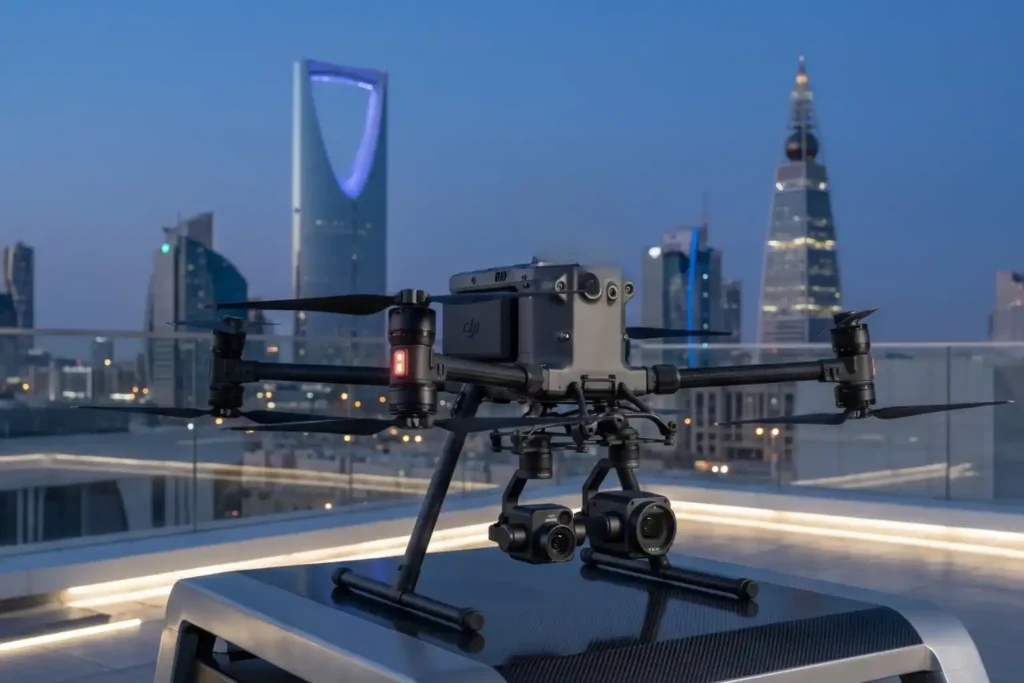
في عام 2026، تمثل صناعة الطائرات بدون طيار في المملكة العربية السعودية جزءًا أساسيًا من التحول الرقمي للمملكة وأهداف رؤية 2030. يتطلب تشغيل طائرة بدون طيار بشكل احترافي أكثر من مجرد جهاز تحكم؛ بل يتطلب إطارًا قانونيًا متعدد الخطوات. يضمن اتباع لوائح الهيئة العامة للطيران المدني تحقيق أهداف عملك كجزء من مجال جوي آمن ومتكامل. هذا الدليل [...]
الدليل الكامل لبرامج DJI Enterprise: من البيانات إلى المعلومات الاستخباراتية

لم تعد الطائرات بدون طيار وحدها كافية للأغراض التشغيلية. فبينما تعد الطائرة عالية الأداء “عضلات” العملية، إلا أنها مجرد وسيلة للمستشعرات. لتحقيق قيمة حقيقية، هناك حاجة إلى برامج موثوقة لمعالجة كميات كبيرة من البيانات التي يتم الحصول عليها أثناء مهام ميدانية. تعقيد البنية التحتية الحديثة يعني أن “مقاس واحد يناسب الجميع” [...]
ليدار الساحلي: رسم خرائط دقيق لترميم بيئة المملكة العربية السعودية

واجهت النظم البيئية الساحلية في الخليج العربي ضغوطًا بيئية هائلة تاريخيًا، خاصةً بعد الاضطرابات البيئية الكبيرة في أوائل التسعينيات. إدراكًا للحاجة الملحة لاستعادة مستدامة، أجرينا مسحًا ساحليًا لاستعادة الـ LiDAR بالطائرات بدون طيار لتوفير بيانات عالية الدقة اللازمة للمعالجة البيئية. لم تكن هذه المهمة مجرد رسم خرائط؛ بل […]
حلول آيرين الذاتية: تحويل الرصد البيئي

مع تقدمنا في عام 2026، بلغت الدعوة العالمية نحو صافي الانبعاثات الصفرية والمسؤولية البيئية نقطة تحول حرجة. المراقبة التقليدية التي تعتمد على أخذ العينات يدويًا أو أجهزة الاستشعار الثابتة لم تعد كافية لتلبية السرعة والدقة التي تتطلبها الأطر التنظيمية الحديثة مثل OGMP 2.0. “النقاط العمياء” في المنشآت الصناعية والنظم البيئية المائية [...]
دمج حيازة البيانات في الوقت الحقيقي ومعالجة نظم المعلومات الجغرافية في الذكاء الصناعي
في الحقبة التقليدية لرسم الخرائط بالطائرات بدون طيار، كان التقاط الصور الجوية هو نصف المعركة فقط. لسنوات، كانت عملية المعالجة هي عنق الزجاجة، حيث يتم تحميل آلاف الصور عالية الدقة على محطات عمل محلية استغرقت أيامًا لإنتاج صورة جوية واحدة متعامدة. أدت هذه المقاربة المجزأة إلى صوامع بيانات، ونتائج غير متناسقة، ونقص في [...]
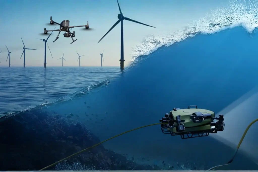
تأمين الأصول البحرية من خلال الفحص بالمركبات المسيرة عن بعد (ROV) والاختبارات غير الهدامة تحت الماء.
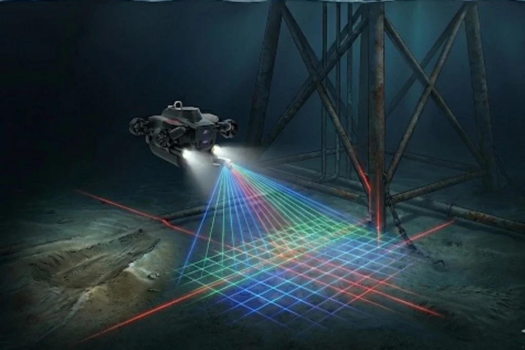
بينما يتعجب العالم من ناطحات السحاب الشاهقة في الرياض والجدران العاكسة في نيوم، تحدث ثورة بنية تحتية ثانية لا تقل طموحًا تحت الأمواج. البنية التحتية البحرية للمملكة العربية السعودية، الممتدة عبر البحر الأحمر والخليج العربي، تضم شبكة واسعة وغير مرئية من خطوط الحياة تحت سطح البحر، بما في ذلك خطوط أنابيب النفط والغاز، [...]
ملخص 2025 من تيرا درونز العربية
مع إسدال الستار على عام 2025، يتغير المشهد الصناعي للمملكة العربية السعودية بشكل جذري. ما كان ذات يوم أفقاً تهيمن عليه العمالة اليدوية التقليدية والمسح الأرضي، انتقل إلى مجال عالي السرعة يعتمد على البيانات يُعرف باقتصاد الارتفاعات المنخفضة (LAE). وفي قلب هذه الثورة تقف شركة تيرات درونز العربية (TDSA). هذا تيرات […]
تقدير غير المرئي: معدات مستقلة للمراقبة البيئية الشاملة.
تشعر شركات الطاقة البحرية اليوم بتهديد مزدوج غالبًا ما يكون غير مرئي للعين المجردة. يكمن التهديد الأول في تسرب غاز الميثان في الهواء، وهو غاز دفيئة قوي. ويتمثل التهديد الثاني في الأضرار البيئية التي تلحق بقاع البحر تحت المنصة. لعقود من الزمن، تم تقدير هذه الآثار باستخدام حسابات أو نماذج متقطعة […]
كيف قامت طائرة بدون طيار بمسح أكثر من 100 كيلومتر مربع في أقل من شهر
لقد قمنا بتسليم طبوغرافيا ساحلية عالية الدقة لدعم تخطيط غابات المانجروف وتقييم الأثر البيئي عبر أكثر من 100 كيلومتر مربع على طول ساحل المنطقة الشرقية، مقسمة إلى عدة قطاعات ساحلية. انتهت عملية جمع البيانات الميدانية في شهر واحد، وتطلب المعالجة شهرين، ليصبح إجمالي التسليم أقل من 3 أشهر من البداية إلى النهاية. كان الهدف هو استخدام تقنية ليدار بالطائرات المسيرة + […]
تطبيقات الطائرات بدون طيار للبيئة: من التصحر إلى الاستجابة للكوارث

تُعيد تطبيقات الطائرات بدون طيار في الإدارة البيئية تعريف كيفية تعامل الصناعات والحكومات ومنظمات الحفاظ على البيئة مع التحديات البيئية الملحة بسرعة. نظرًا لأن المملكة العربية السعودية ومنطقة الشرق الأوسط وشمال إفريقيا الأوسع تواجهان مخاطر مناخية متسارعة من التصحر إلى انبعاثات غازات الاحتباس الحراري، هناك حاجة ماسة لحلول قابلة للتطوير ومدفوعة بالتكنولوجيا. تعمل الطائرات بدون طيار الآن كقوة مضاعفة في هذه المهمة، حيث تجمع بين القدرات الجوية [...]